Morgan County is organized around Martinsville in the south-central county and Mooresville in the northeast, with Brooklyn, Monrovia, Morgantown, and Paragon providing smaller references around them. You can download the high-resolution JPG ZIP directly from this page. The archive is intended for visitors who need larger Morgan County road labels, creek names, settlement details, and relief shading. This Morgan County Indiana Map page combines the Martinsville–Mooresville road pattern with a six-place city index, White River and its tributaries, and a 170–296 meter elevation surface shaped by broad low valleys and steep ridges.
Martinsville is the best starting point because it has the largest southern developed footprint and sits close to several major road lines. North of the city, Centerton, Bethany, and Brooklyn create a chain toward Mooresville. Monrovia provides a northwestern reference, while Paragon and Morgantown separate the southwest and southeast. The map therefore reads less like a single continuous urban corridor and more like several settlement clusters divided by creek valleys and hills.
The terrain maps make that division much clearer. White River crosses the central and eastern lowlands, White Lick Creek descends from the north, and Sycamore Creek cuts through the north-central hills. Indian Creek and Crooked Creek define long southern and eastern valleys. The supplied elevation legend reports an actual range of about 170 to 296 meters and a mean of 220 meters, with strong ridges rising west of the river corridor and again across parts of the north and southeast.
Table of Contents
Martinsville and Mooresville frame the main north–south settlement pattern
Martinsville has the largest developed footprint in the southern half of the general map. Route 39 approaches from the north and runs along the western side of the city, while Route 67 provides another strong north–south reference. Route 44 heads east from Martinsville toward the Painted Hills side, and Routes 252 and 135 help define the southeastern corner. The Morgan County Sheriff’s Office and Indiana University Health Morgan are both labeled near the city and provide additional local anchors.
North of Martinsville, Centerton and Bethany appear before the map reaches Brooklyn and Mooresville. Mooresville is a substantial developed area in its own right, with Route 37 and Route 144 nearby. Brooklyn lies just south of Mooresville, while Waverly sits farther east close to the White River side. This sequence is useful when switching between the road, water, and elevation views because the White River lowland runs close to the same eastern corridor.
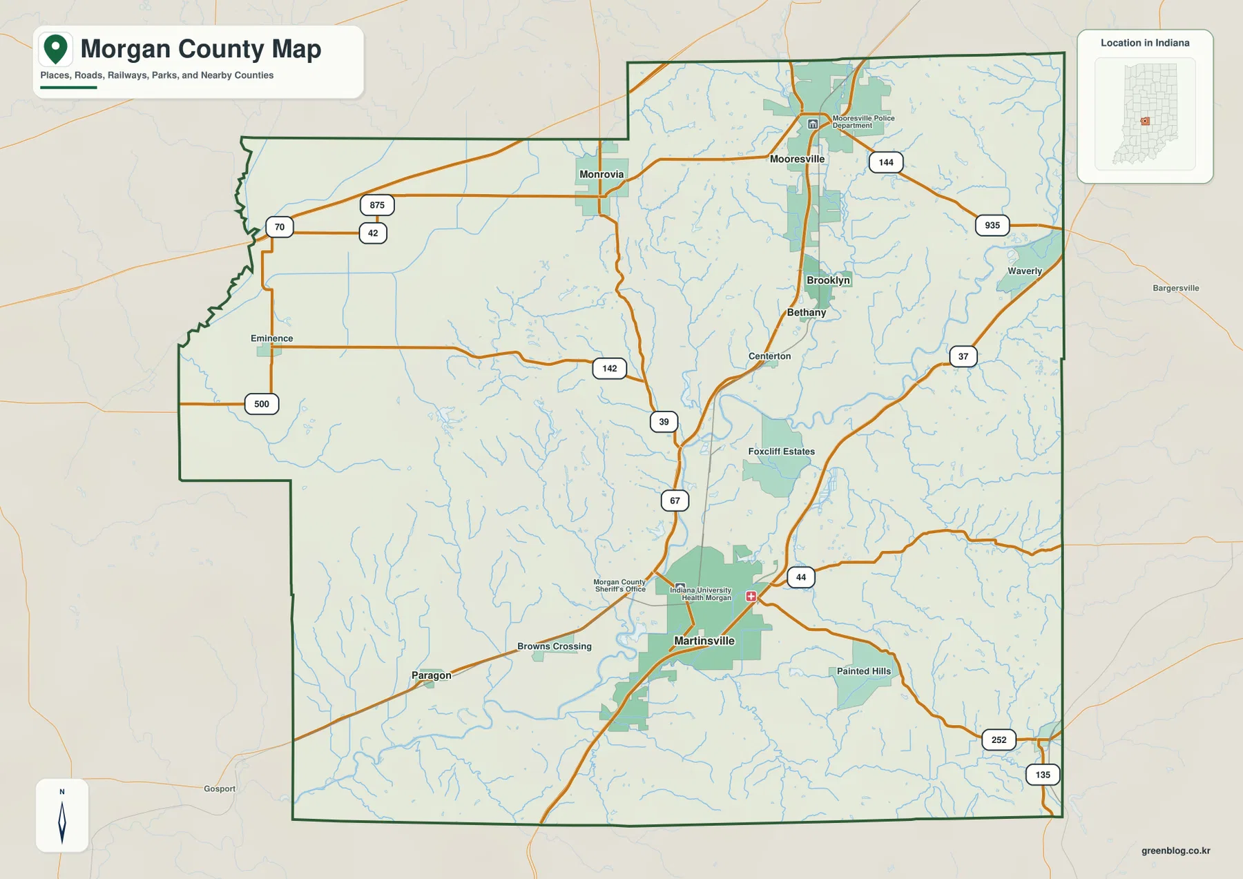
Monrovia anchors the northwest and sits amid a more open road pattern than Mooresville. Routes 42 and 70 provide useful western references, while Eminence lies closer to the far western edge. The northwestern county contains fewer large developed areas, so the road grid and drainage lines become increasingly important for orientation.
Paragon occupies the southwest beyond Browns Crossing, and the road network thins as it moves away from Martinsville. Painted Hills lies east of the city, while Morgantown marks the southeastern side of the county. In these outer areas, the county boundary and creek valleys can be more useful than any single route number, especially when matching the general map with the physical-geography views.
The city index shows Martinsville and Mooresville as two large centers
The supplied city index highlights Martinsville, Mooresville, Brooklyn, Monrovia, Morgantown, and Paragon. Martinsville is printed at 11,933 and Mooresville at 9,751. Brooklyn follows at 2,570, Monrovia at 2,055, Morgantown at 1,308, and Paragon at 537. These figures belong to the supplied map edition rather than a live demographic feed, so their main value here is comparing the scale and position of the highlighted communities.
| Rank | Place | Value printed on map | Position |
|---|---|---|---|
| 1 | Martinsville | 11,933 | South-central |
| 2 | Mooresville | 9,751 | Northeast |
| 3 | Brooklyn | 2,570 | Northeast, south of Mooresville |
| 4 | Monrovia | 2,055 | Northwest |
| 5 | Morgantown | 1,308 | Southeast |
| 6 | Paragon | 537 | Southwest |
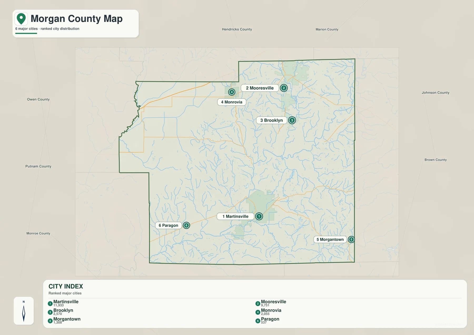
The relatively small gap between Martinsville and Mooresville is important because Morgan County does not have only one dominant settlement center. Even so, the two developed areas are separated by smaller communities and rural terrain rather than forming one uninterrupted urban strip. Monrovia and Paragon define the west, while Morgantown gives the southeastern county its clearest town reference.
The detailed general map also includes Eminence, Waverly, Centerton, Bethany, Painted Hills, and Browns Crossing, which are not part of the six-place index. Use the general map for those smaller names and their road relationships. Use the index for a stripped-down comparison of the six highlighted places. Current population analysis should rely on an up-to-date official source instead of the printed values alone.
White River creates the main lowland while creeks cut through the surrounding hills
White River is the strongest feature on the terrain-and-water map. Its broad bends occupy the central and eastern lowland and then continue toward the southern part of the county. Because the river corridor is wide and visually distinct, it is the easiest feature to use when road labels disappear and the map shifts from settlement geography to terrain.
White Lick Creek descends from the north, while Sycamore Creek cuts through the hillier north-central interior. Hart Lake, Whippoorwill Lake, and Old Swimmin Hole Lake provide small water landmarks in the same general part of the county. These lakes are far smaller than the river system, but their fixed shapes help relocate specific creek corridors when comparing maps.
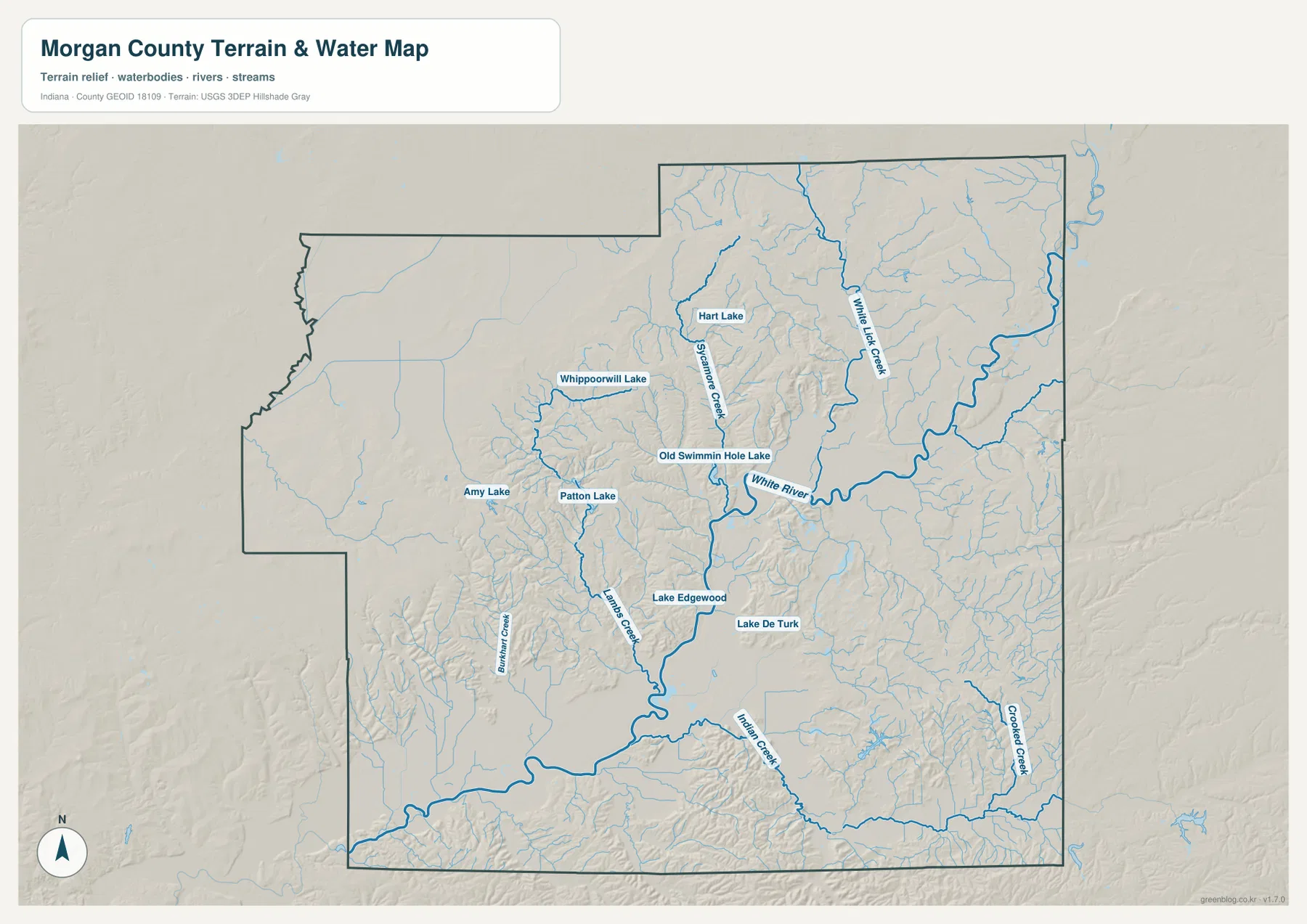
Indian Creek forms a long southern corridor, and Crooked Creek runs near the eastern side of the lower county. Lake Edgewood and Lake De Turk provide small central-southern water references. Lambs Creek and Burkhart Creek divide the western hills. Taken together, the map shows a county where valleys and tributaries are more important geographic markers than large lakes.
Morgan County’s own stormwater documentation discusses the West Fork White River as a major local water resource, and Martinsville planning documents also treat the river as a recreation and trail corridor. The supplied terrain-and-water map is still a reference for location and landform relationships. Flood risk, current water conditions, navigation, property limits, and legal stream boundaries require the appropriate current agency source.
The 170–296 m relief separates White River lowlands from strong ridge country
The elevation legend gives an actual Morgan County range of about 170 to 296 meters and a mean of 220 meters. The White River and major creek valleys appear as broad green lowlands, while higher yellow, tan, and brown ground rises across the west-central hills, north-central ridges, and parts of the southeast.
The north-central county contains some of the most tightly packed ridges. Sycamore Creek and White Lick Creek cut lower green corridors between high brown bands, producing a clear ridge-and-valley texture. The northeastern edge becomes lower in places, but nearby high ground prevents the whole upper county from reading as one smooth plain.
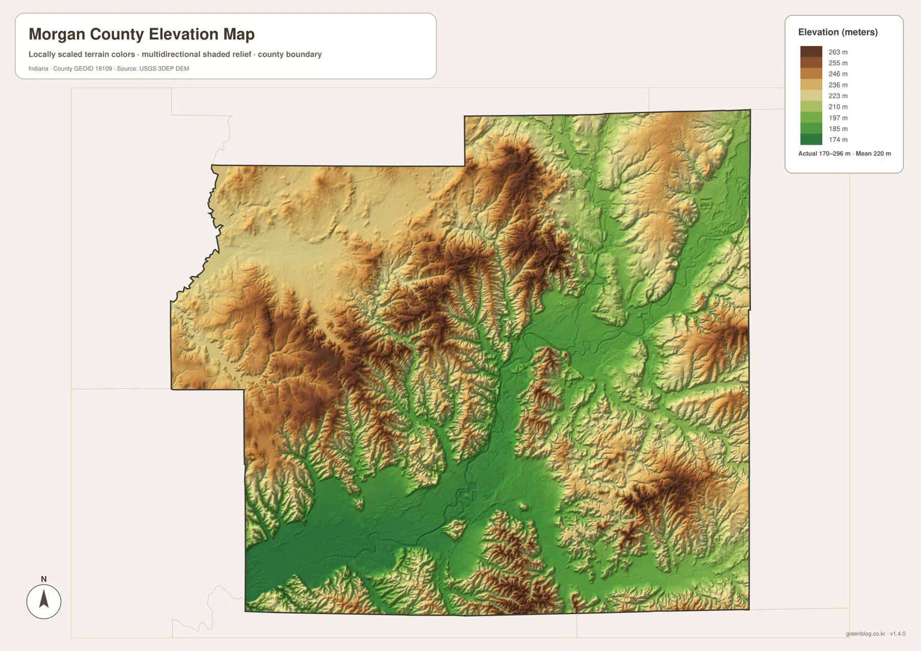
South and west of Martinsville, the terrain climbs quickly away from the river corridor. Paragon and Monrovia sit closer to broad upland areas cut by many short drainage lines. In the southeast, Indian Creek and Crooked Creek form lower valleys through another set of elevated ridges, creating a landscape that is much more dissected than the road map alone suggests.
Indiana DNR describes Morgan-Monroe State Forest as a property of more than 24,500 acres spanning Morgan and Monroe counties, with many steep ridges and valleys. That description fits the southern Morgan County relief visible here, where high hills and narrow drainage cuts repeat over a short distance. The elevation image is meant for county-scale comparison, however, not for exact site measurements.
A practical way to read the full elevation surface is to start with the White River lowland and then work outward into the ridge belts. Mooresville sits nearer lower and gentler terrain in the north, while west-central and southern areas become more rugged. For a parcel, building site, roadway grade, or drainage design, use original elevation data or a qualified survey rather than this county-scale relief image.
Keep Martinsville fixed while comparing settlements, White River, and the ridge belts
For settlements and roads, begin with Martinsville and then trace the northward sequence through Centerton, Bethany, Brooklyn, and Mooresville. Add Monrovia to the northwest, Paragon to the southwest, and Morgantown to the southeast. Routes 39, 67, 44, 37, and 144 provide useful road references for moving between the main settlement areas.
The city index is most useful when the goal is to compare the six highlighted communities without the dense road and drainage network. Martinsville and Mooresville stand out as two large centers, while Brooklyn, Monrovia, Morgantown, and Paragon define different outer parts of the county. For smaller place labels or detailed route relationships, return to the general map.
For physical geography, locate White River first and then add White Lick Creek, Sycamore Creek, and Indian Creek. Move to the elevation view at those same locations and the structure becomes clear: the river and creek corridors remain low while the surrounding hills rise sharply, especially in the north-central, west-central, and southern parts of the county.
The WebP images on this page are reduced previews. The Morgan County archive contains four original 3638×2572-pixel JPG files covering the general county map, city index, terrain-and-water map, and elevation map. The larger originals are better for printing or reading small road, creek, lake, and settlement labels.
A useful comparison is to keep Martinsville fixed as the central-southern reference. Find Mooresville, Monrovia, and Morgantown on the general map, compare the six highlighted places on the city index, trace White River and White Lick Creek on the water map, and finish by matching those valleys to the surrounding ridge belts on the elevation image.
Frequently Asked Questions
Which places have the largest values on the supplied city index?
Martinsville is printed at 11,933 and Mooresville at 9,751, followed by Brooklyn at 2,570, Monrovia at 2,055, Morgantown at 1,308, and Paragon at 537. These values belong to the supplied map edition rather than a live demographic feed.
Which waterways are easiest to recognize?
White River is the strongest central and eastern reference. White Lick Creek descends from the north, Sycamore Creek cuts through the north-central hills, and Indian Creek and Crooked Creek define important southern and eastern valleys. Use this Morgan County water view for geographic orientation only; flood status and legal stream limits require current agency information.
Can the 170–296 m elevation range be used for exact site measurements?
No. The elevation image gives a county-wide range with a mean of 220 meters and is intended for comparing river and creek lowlands with surrounding ridges. For parcel-scale elevation, construction, roadway-grade, or drainage work in Morgan County, consult original terrain data or a qualified survey.
Map File Information
The Morgan County ZIP combines the general road-and-place map, six-place city index, terrain-and-water map, and elevation map as full-resolution JPG originals.
- File Type: ZIP containing four 3638×2572px JPG files
Related Maps
Sources and References
The article is based primarily on the supplied Morgan County map set and asset manifest. The following official sources provide county, White River, forest, boundary, hydrography, and elevation context.
- Morgan County, Indiana – official county government information centered in Martinsville
- Indiana DNR – Morgan-Monroe State Forest – official information on the steep ridge-and-valley forest south of Martinsville
- U.S. Census Bureau TIGER/Line Shapefiles – boundary reference for Morgan County and its place framework
- USGS National Hydrography – reference data for White River, creeks, and mapped water features
- USGS 3D Elevation Program – source terrain data for detailed elevation work
Green Map creates custom-edited map images using open geographic data sources such as geoBoundaries, Natural Earth, OpenStreetMap, and government open data.
These maps are edited visual materials, not raw data files, and are provided for education, documents, presentations, and graphic reference.