Downloadable Washington County Mississippi Map files are provided on this page for readers who need a larger road, city, water, or elevation reference. Greenville anchors the western side of the county, and US 82 provides the clearest east-west route to Leland. Farther south, Arcola, Hollandale, and Glen Allan occupy separate parts of the Delta plain. The terrain-and-water view adds Bogue Phalia, Black Bayou, Bear Creek, Big Sunflower River, Lake Washington, and other channels, while the elevation map records an actual range of about 27 to 68 meters and a mean near 34 meters. The A3 JPG originals are packaged in the ZIP below.
Washington County belongs to the Mississippi Delta, but its map is more varied than a flat agricultural rectangle. The Mississippi River bends repeatedly along the west, creating an irregular county edge and leaving a landscape of curved water features and low ridges. Greenville sits close to that river side, while Leland is farther inland on the US 82 corridor. East and south of those cities, long drainage lines and naturally winding bayous cross broad fields. Reading the road map beside the water and elevation views makes it easier to distinguish the river-facing west from the interior Delta plain.
Table of Contents
Quick Facts
The Census material supplied with the package lists 44,922 residents in the 2020 census and a July 2025 estimate of 40,446. Because those figures come from different reference dates and methods, they are better treated as separate benchmarks for recent county size than as identical measurements taken five years apart. Washington County’s FIPS code is 28151, and Greenville is the county seat.
The 2025 Gazetteer values in the package list 724.147 square miles of land and 36.218 square miles of water. Dividing the 2020 census count by the listed land area gives about 62.0 residents per square mile. That number summarizes the county as a whole; it does not describe the actual distribution of people between Greenville, the smaller towns, agricultural land, river bends, lakes, and drainage corridors.
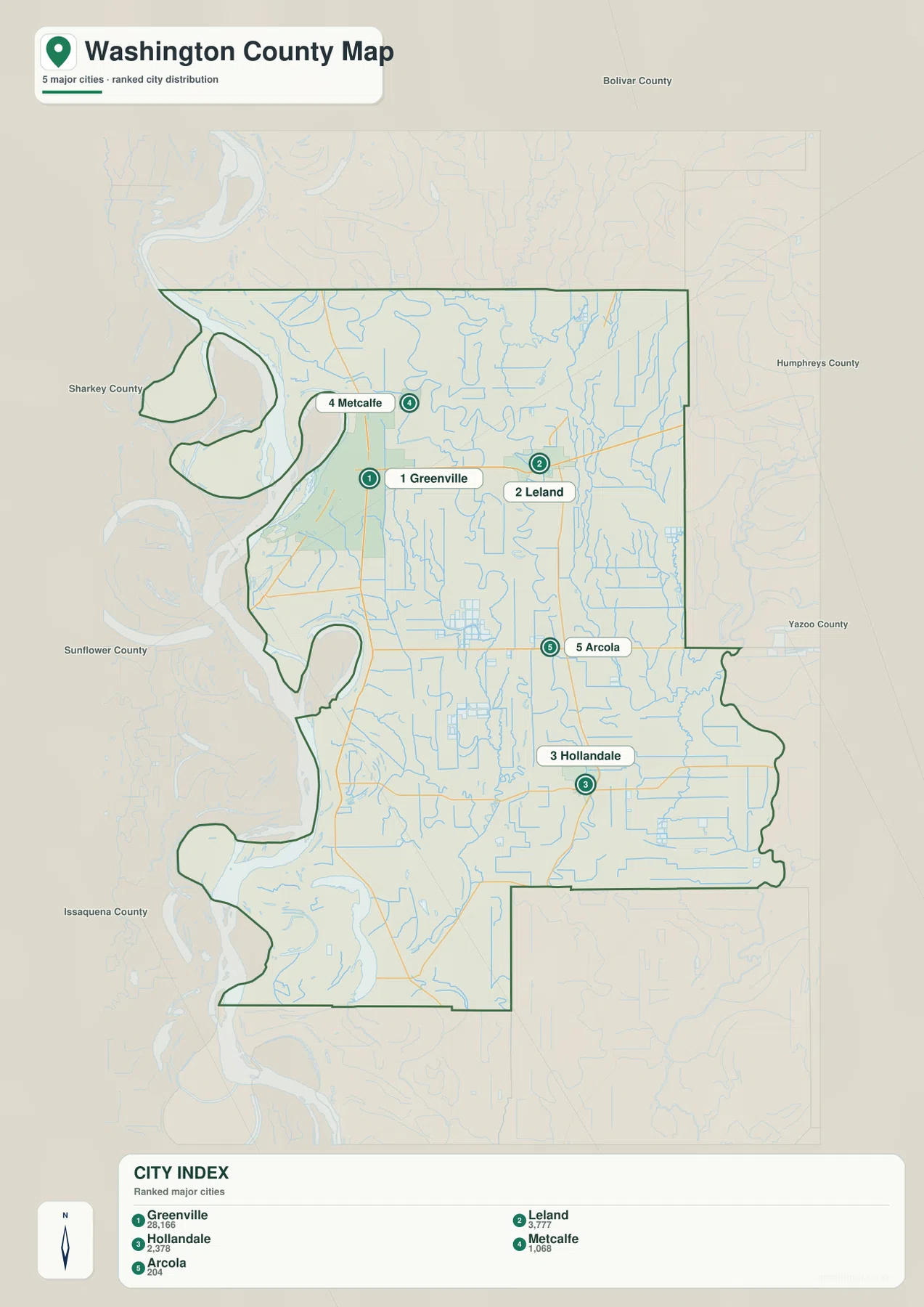
The ranked city map contains five selected places. Greenville is shown at 28,166 residents, followed by Leland at 3,777, Hollandale at 2,378, Metcalfe at 1,068, and Arcola at 204. These labels compare the relative scale of the mapped cities rather than replacing the countywide population total. Their positions are just as useful as the numbers: Greenville occupies the west, Leland lies east along US 82, and Arcola with Hollandale extends the settlement pattern well into the southern half.
Reading the Washington County Mississippi map
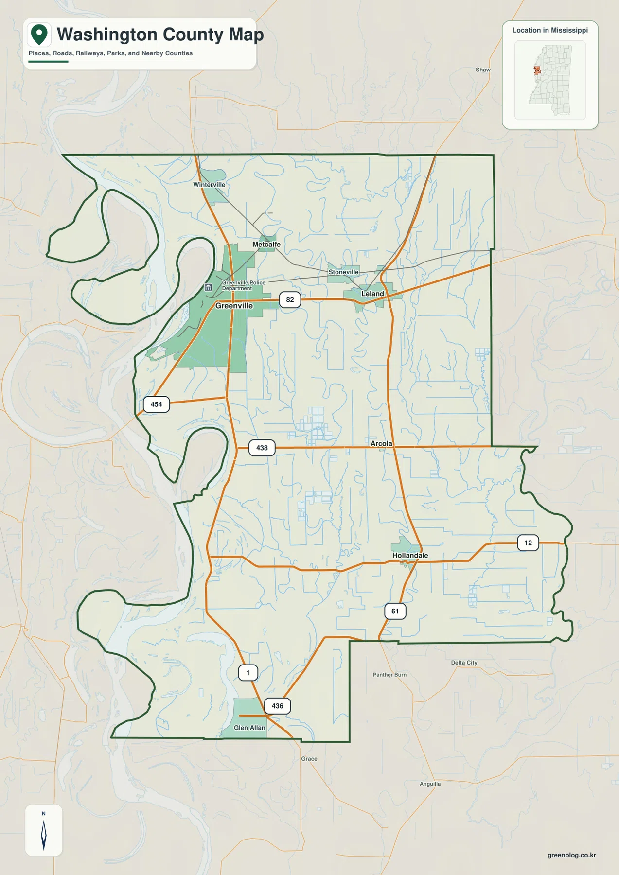
US 82 is the simplest route to trace first on the general county map. It crosses the Greenville area and continues east through Leland, making the relationship between the county’s two largest mapped cities immediately clear. MS 1 runs along the western interior near Greenville and continues south, while US 61 becomes an important north-south reference through the Leland-Hollandale side. Once those corridors are located, Metcalfe, Stoneville, and Arcola are much easier to place.
MS 438 crosses the Arcola area, and MS 12 runs through Hollandale toward the east. Glen Allan in the southwest is close to the MS 1 and MS 436 side, while MS 454 provides another road reference near Greenville’s river-facing side. Rather than treating the map as a list of highway numbers, it is more useful to see US 82 as the Greenville-Leland link and then follow the north-south routes into the southern Delta communities.
Winterville appears near the northern edge, Metcalfe lies northeast of Greenville, and Stoneville sits closer to the Greenville-Leland corridor. Arcola is farther south, with Hollandale in the southeast and Glen Allan in the southwest. Those place names divide a large county into recognizable sections and show why Greenville alone cannot stand in for the entire settlement pattern.
Boundary, Water, and Terrain
The Mississippi River creates the most irregular part of the county boundary. Broad bends along the western side produce deep indentations and projecting sections of county land, especially north and south of the Greenville area. The present river channel and the legal county or state boundary should not automatically be assumed to coincide in every bend. For precise jurisdiction, a current official boundary dataset is more appropriate than reading the visible channel centerline from a general map.
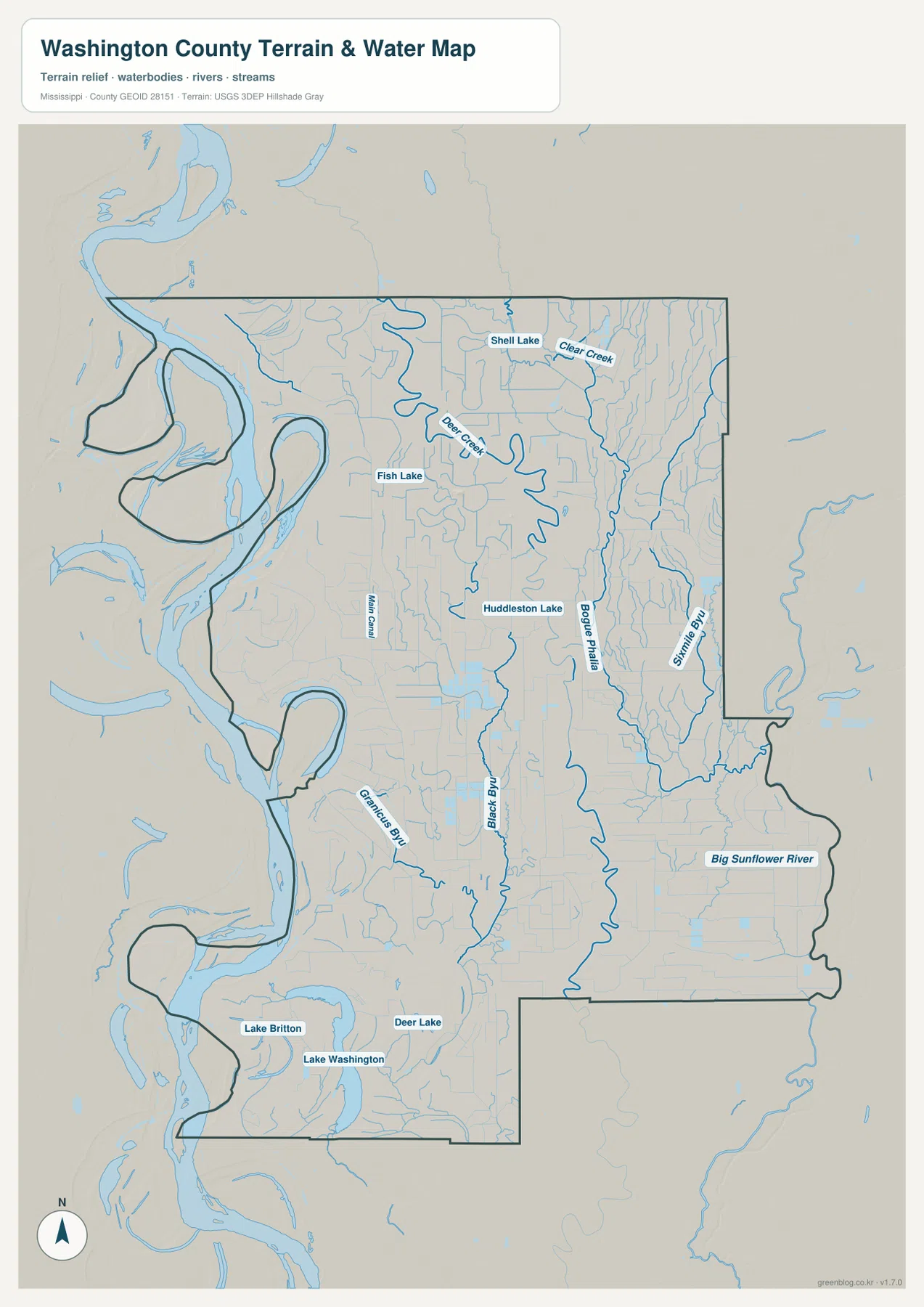
Inside the county, Bear Creek is one of the strongest named channels in the north-central area, with Clear Creek farther east. Shell Lake and Fish Lake provide small northern water references, and Huddleston Lake appears closer to the middle. Bogue Phalia then becomes a major winding interior channel, while Black Bayou and Main Canal occupy separate paths to its west. The difference between naturally curving waterways and straighter drainage lines is easy to see in the agricultural grid.
Big Sunflower River runs through the eastern and southeastern side of the supplied map. Grampus Bayou lies farther southwest, and the lower-left part of the county contains Lake Washington, Lake Britton, and Deer Lake. This combination of a huge boundary river, meandering interior bayous, engineered-looking drainage lines, and small lakes gives Washington County a particularly dense water pattern for a Delta county.
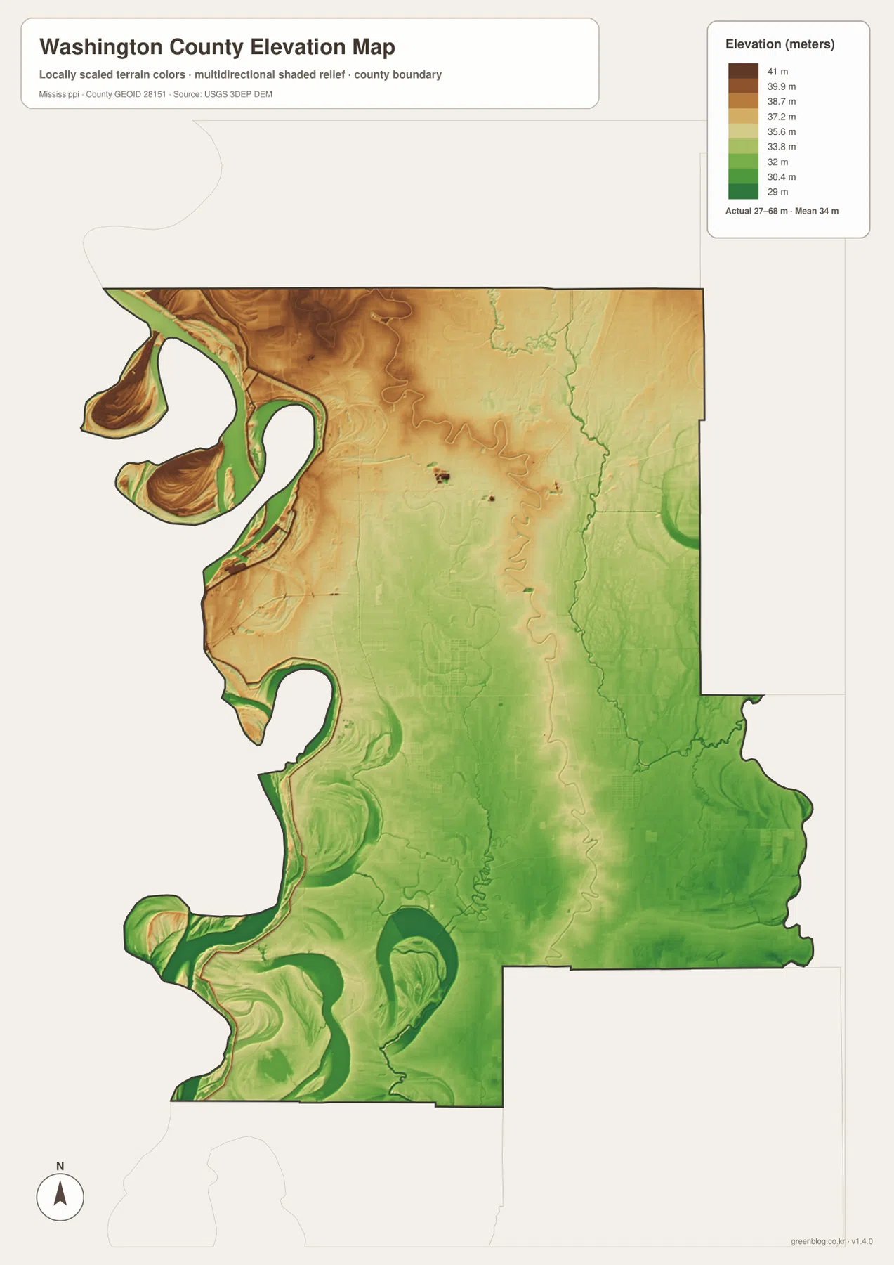
The elevation map prints an actual range of about 27 to 68 meters and a mean near 34 meters. Most of the county is low Delta terrain, yet the surface is not uniform. Warmer brown and tan colors are especially noticeable in the northwest near the river bends, while greener low ground becomes more extensive through the center, south, and east. Narrow curved bands around the river-facing side make subtle relief much more visible than it appears on the road map.
Looping and crescent-shaped elevation features are especially common in the southwest. Some resemble nearby water bends, while others are separated from the current channel. They are useful clues to a river-shaped landscape, but this county overview should not be used to classify every curved feature as a confirmed abandoned channel. The safer interpretation is that Washington County’s floodplain contains many small elevation differences associated with a long history of water movement.
The east and southeast are generally lower and smoother in the elevation view, with Bogue Phalia and Big Sunflower River occupying long low corridors. A difference of a few tens of meters may sound minor compared with hill country elsewhere in Mississippi, but it is meaningful across a broad Delta plain. Exact field elevations, levee heights, drainage engineering, and flood-insurance questions still require more detailed official data.
Settlement and Regional Context
Greenville is the county seat and the dominant city on the supplied city map. Its location close to the Mississippi River combines county government, health services, commerce, and river-related activity in one part of Washington County. US 82 then carries the strongest eastward connection toward Leland, so the two cities provide a practical framework for understanding the northern half without treating them as one continuous urban area.
Leland has a distinct role farther inland. The existing package describes it as a US 82 community with strong Delta cultural associations, while Metcalfe and Stoneville provide smaller location references between and around the two larger cities. Farther south, Arcola and Hollandale form separate settlement points in a landscape increasingly dominated by fields, drainage lines, and lower terrain.
The existing source catalog also includes Leroy Percy State Park near the Hollandale side as a regional natural-landscape reference. The maps on this page are not detailed park maps, but that source is useful for remembering that the southeastern county landscape includes forest and wetland settings in addition to farms and towns. Current park hours, recreation rules, and facility information should be checked with the official park page.
Practical Map Uses
A straightforward way to orient yourself is to locate Greenville first and follow US 82 east to Leland. After that, compare the positions of Arcola and Hollandale farther south and notice how the road grid spreads across the Delta plain. Adding the Mississippi River bends on the west explains why Greenville has a river-facing role while Leland is a more inland reference.
For physical geography, find Bogue Phalia, Big Sunflower River, and Bear Creek on the water view and then match them with the elevation colors. The slightly higher northwestern river-side terrain contrasts with the lower central and southern plain, while Lake Washington and other southwestern waters add useful detail to the river-shaped landscape. This sequence is often clearer than trying to interpret roads, waterways, and elevation all at once.
The WebP graphics in the article are optimized for quick page viewing. Use the high-resolution JPG originals in the ZIP for A3 printing, cropping, or editing work. These maps are general geographic references rather than parcel surveys, levee-management plans, flood maps, navigation charts, or live road products, so specialized current sources are needed for those decisions.
Frequently Asked Questions
Is Lake Ferguson the Mississippi River’s main channel?
No. The existing material supplied with this package describes Lake Ferguson as a river-connected bend and harbor waterbody near Greenville, not as identical to the Mississippi River’s active navigation channel. Water level, connectivity, and navigation conditions can change, so current river or port information is the better source for operational details.
Which different map roles are served by Greenville, Mississippi River, and the Bolivar side?
Greenville is the main settlement and county-seat reference, the Mississippi River explains the irregular western landscape, and the Bolivar County side helps orient the northern edge. They answer different location questions, so using all three references prevents a reader from treating the county as a single Greenville-centered point on the Delta.
Map File Information
The ZIP packages the Washington County county, city, water, and elevation maps as high-resolution A3 JPG files. The originals provide more room for road labels, waterways, and terrain detail than the WebP page previews.
- File Type: four high-resolution JPG files in one ZIP
Related Maps
Sources
- U.S. Census Bureau QuickFacts for Washington County — population reference
- U.S. Census Bureau Gazetteer Files — land and water area reference
- Mississippi Department of Transportation Official Highway Map — US 82, US 61, MS 1, and state-road reference
- USGS National Hydrography — river, creek, bayou, and lake reference
- USGS 3D Elevation Program — elevation and terrain reference
- Leroy Percy State Park — southeastern regional landscape reference
Green Map creates custom-edited map images using open geographic data sources such as geoBoundaries, Natural Earth, OpenStreetMap, and government open data. These maps are edited visual materials, not raw data files, and are provided for education, documents, presentations, and graphic reference.