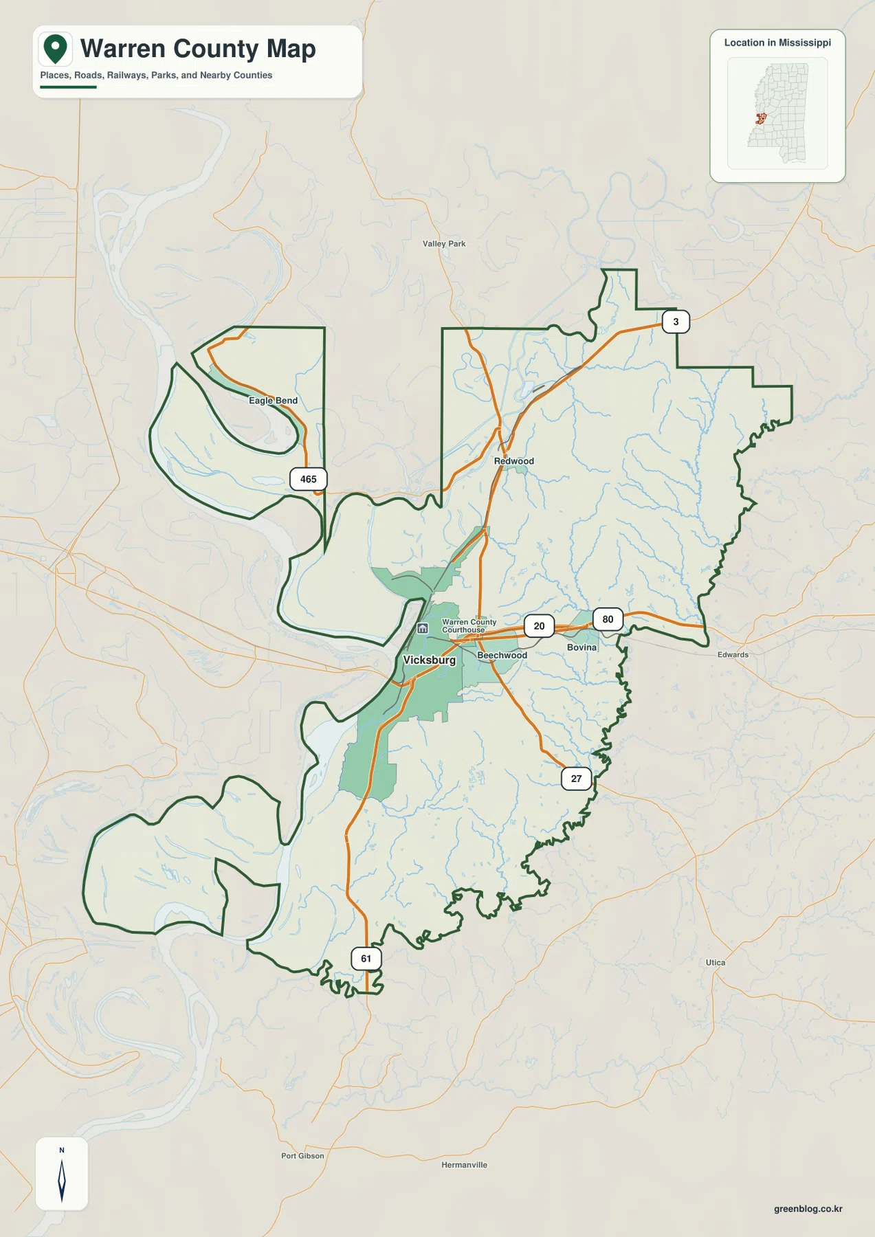
High-resolution Warren County Mississippi Map files can be downloaded from this page. Vicksburg provides the main reference for the county: I-20 and US 80 cross the Mississippi River there, US 61 follows the city north-south, and the road network continues east through Beechwood and Bovina. The water view adds the Yazoo River, Deer Creek, Corn House Creek, Bear Creek, Clear Creek, and several lakes, while the elevation map shows an actual range of about 17 to 120 meters. That elevation difference matters because the broad river lowlands on the west give way abruptly to much higher, deeply cut hills east and northeast of Vicksburg. The ZIP below contains the supplied county, city, water, and elevation maps as A3 JPG originals.
Warren County is often associated with Vicksburg and the Mississippi River, but the maps show a more varied landscape than a simple riverfront description suggests. The western side is low and shaped by large river bends, while the interior rises into a dense network of ridges and narrow valleys. Vicksburg sits close to that transition. Modern highways, historical sites, river corridors, and rugged loess terrain all meet within a relatively short distance, which makes the county especially useful for comparing transportation and physical geography on the same page.
Table of Contents
Quick Facts
The Census references included in the package list 44,722 residents in the 2020 census and a July 2025 estimate of 41,759. These figures use different reference dates and methods, so they are best treated as separate benchmarks for recent county size. Warren County’s FIPS code is 28149, and Vicksburg is the county seat.
The supplied 2025 Gazetteer values divide the county into 588.536 square miles of land and 30.017 square miles of water. Using the 2020 population with the listed land area gives about 76.0 residents per square mile. That countywide average combines a substantial urban center, Mississippi River lowlands, lakes, forested hills, and scattered rural settlement, so it should not be read as an even density across the map.
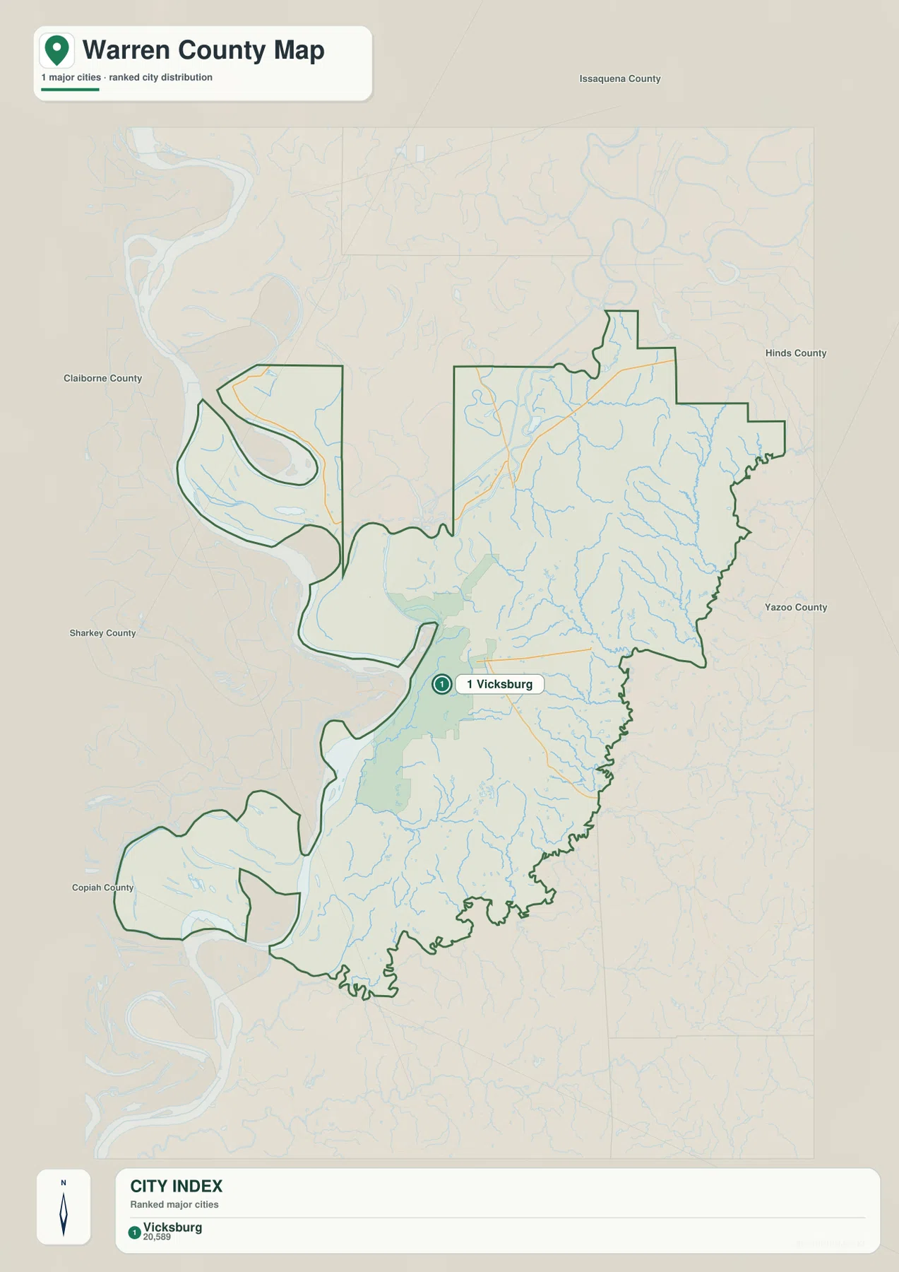
The ranked city map contains one major city: Vicksburg, shown at 20,589 residents. Surrounding county labels provide wider orientation, including Issaquena, Hinds, Yazoo, Claiborne, Sharkey, and Copiah. The point of this simplified city map is not to imply that no smaller communities exist; it emphasizes how strongly Vicksburg dominates the county’s urban pattern.
Reading the Warren County Mississippi map
I-20 and US 80 are the easiest routes to follow first. They cross the Mississippi River at Vicksburg, continue west into Louisiana, and run east through the Beechwood-Bovina side of Warren County before reaching Hinds County. That bridge-and-highway relationship immediately explains why Vicksburg is more than a local county-seat reference. It sits on one of the clearest east-west crossings of the river in this part of the Lower Mississippi Valley.
US 61 provides the main north-south road reference through and south of Vicksburg. MS 27 leaves the Bovina side and continues toward the southeastern county boundary, while MS 3 is visible in the northeast. MS 465 serves the Eagle Bend side near one of the large river loops. Rather than memorizing every route number, readers can use I-20 as the east-west anchor and US 61 as the north-south anchor, then place the smaller state highways around those two lines.
Beechwood lies immediately east of the Vicksburg urban area, with Bovina farther east. Redwood is a northern rural reference, while Eagle Bend occupies the unusual river-loop section in the northwest. These labels are most useful for dividing the county into recognizable parts. They should not be confused with the ranked city map, which intentionally gives Vicksburg the only major-city marker.
Boundary, Water, and Terrain
The western county outline is controlled by a landscape of large Mississippi River bends rather than a simple straight line. Eagle Bend and the southwestern projections are especially irregular. Louisiana lies across the river side, while the eastern boundary meets inland Mississippi counties. Because river channels and legal boundaries can have complicated histories, the visible center of the present river should not automatically be treated as the exact county or state line in every bend.
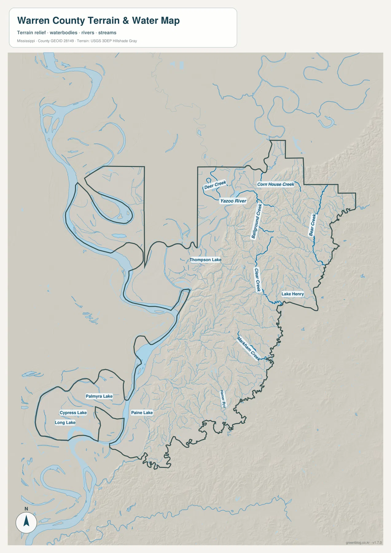
The Yazoo River is a strong water reference in the northern interior. Deer Creek approaches from the west, and Corn House Creek drains a hillier northeastern area. Bear Creek follows a long corridor near the eastern side, while Clear Creek runs through the central part of the county. Lake Henry appears in the east-central section, and Thompson Lake lies in lower terrain northwest of Vicksburg.
The southwest contains a different type of water landscape. Palmyra Lake, Cypress Lake, Long Lake, and Paine Lake sit within broad Mississippi River lowlands rather than narrow hill valleys. This contrast is one of the most useful features of the water map: large river-related lowland water bodies occupy the west, while the eastern half is cut by many smaller creeks descending through higher ground.
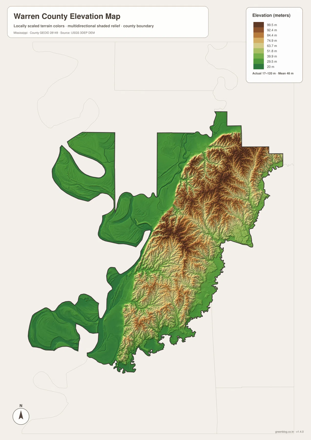
The elevation map prints an actual range of about 17 to 120 meters and a mean of about 48 meters. Deep green lowlands dominate the Mississippi River side, including Eagle Bend and the southwestern river-facing sections. East and northeast of Vicksburg, the colors change rapidly to yellow, orange, and brown as closely spaced ridges rise above narrow valleys. The terrain is much more strongly dissected than the flat western floodplain.
Vicksburg sits close to this physical break. Low waterfront and river-adjacent ground lie immediately to the west, but the city and surrounding area rise into hill country within a short distance. The contrast helps explain why the Vicksburg landscape is visually different from many flatter Delta counties farther north. It also provides useful geographic background for the ridges and ravines preserved within Vicksburg National Military Park.
The elevation colors are intended for county-scale comparison rather than site engineering. They can show the broad river lowland, the higher interior, and the location of major valleys, but they cannot replace surveyed elevations for property work, levee design, construction, road grades, slope stability, or flood decisions.
Settlement and Regional Context
Vicksburg is the county seat and the dominant city in Warren County. Its location combines a Mississippi River crossing, the I-20/US 80 corridor, US 61, local government, health services, commerce, and tourism. On the map, the urban area spreads east from the river toward Beechwood, but it does not fill the county. Large rural sections remain north, east, and south of the city.
Vicksburg National Military Park adds another layer of local context. The National Park Service preserves places associated with the Vicksburg campaign and siege, and the surrounding ridges and ravines are part of why the landscape matters historically. The county map on this page is not a park tour map, so visitors should use the current National Park Service information for entrances, road closures, trails, monuments, and visitor services.
Outside Vicksburg, settlement becomes more dispersed. Beechwood and Bovina provide eastern references along the main highway corridor, Redwood marks the northern interior, and river-loop areas such as Eagle Bend are separated by water and low terrain. Looking at these places together prevents Warren County from being reduced to either “Vicksburg city” or “Mississippi River floodplain.” It contains both, along with extensive inland hill country.
Practical Map Uses
For basic orientation, locate Vicksburg first and trace I-20/US 80 across the Mississippi River and east toward Bovina. Then add US 61 to establish the main north-south direction. Once those roads are clear, the water map helps separate the Yazoo River and eastern creek valleys from the broad Mississippi River lowlands. The elevation view completes the picture by showing how sharply the land rises east of the river.
A classroom or presentation about Vicksburg can pair the general map with the elevation view. The first shows the bridge, highways, city, and neighboring communities; the second shows why the city occupies a much more uneven landscape than the western floodplain. For a physical-geography topic, placing the water and elevation maps side by side makes it easy to compare the low Mississippi-Yazoo system with the narrow valleys cut into the eastern hills.
The WebP graphics in the article are optimized for on-page viewing. Use the high-resolution JPG originals in the ZIP when preparing an A3 print, cropping a map for a slide, or editing a larger graphic. These are general reference maps, not parcel surveys, flood-insurance maps, navigation charts, engineering drawings, park trail maps, or live traffic products.
Frequently Asked Questions
Is Vicksburg directly on the Mississippi River?
Yes. Vicksburg is on the east side of the Mississippi River, close to the transition between low river terrain and higher inland hills. The entire city is not a flat strip at water level, however. Bluffs, lower waterfront areas, and ravines all occur nearby, which is why the road and elevation maps are useful together.
Why is Vicksburg alone insufficient for interpreting Mississippi River near Issaquena?
Vicksburg is the strongest urban reference, but the Mississippi River landscape continues far beyond the city label. Large bends, low floodplain areas, lakes, county boundaries, and the Yazoo River system extend north toward the Issaquena side. A city marker alone cannot show those river relationships, so the water and boundary views are needed for the broader context.
Map File Information
The ZIP contains the Warren County county, city, water, and elevation maps as high-resolution A3 JPG files. The originals provide more space for labels, roads, water features, and terrain detail than the WebP page previews.
- File Type: four high-resolution JPG files in one ZIP
Related Maps
Sources
- U.S. Census Bureau QuickFacts for Warren County — population reference
- U.S. Census Bureau Gazetteer Files — land and water area reference
- Mississippi Department of Transportation Official Highway Map — I-20, US 61, US 80, and state-road reference
- National Park Service Vicksburg National Military Park — regional history and landscape reference
- USGS National Hydrography — river, creek, and lake reference
- USGS 3D Elevation Program — elevation and terrain reference
Green Map creates custom-edited map images using open geographic data sources such as geoBoundaries, Natural Earth, OpenStreetMap, and government open data. These maps are edited visual materials, not raw data files, and are provided for education, documents, presentations, and graphic reference.