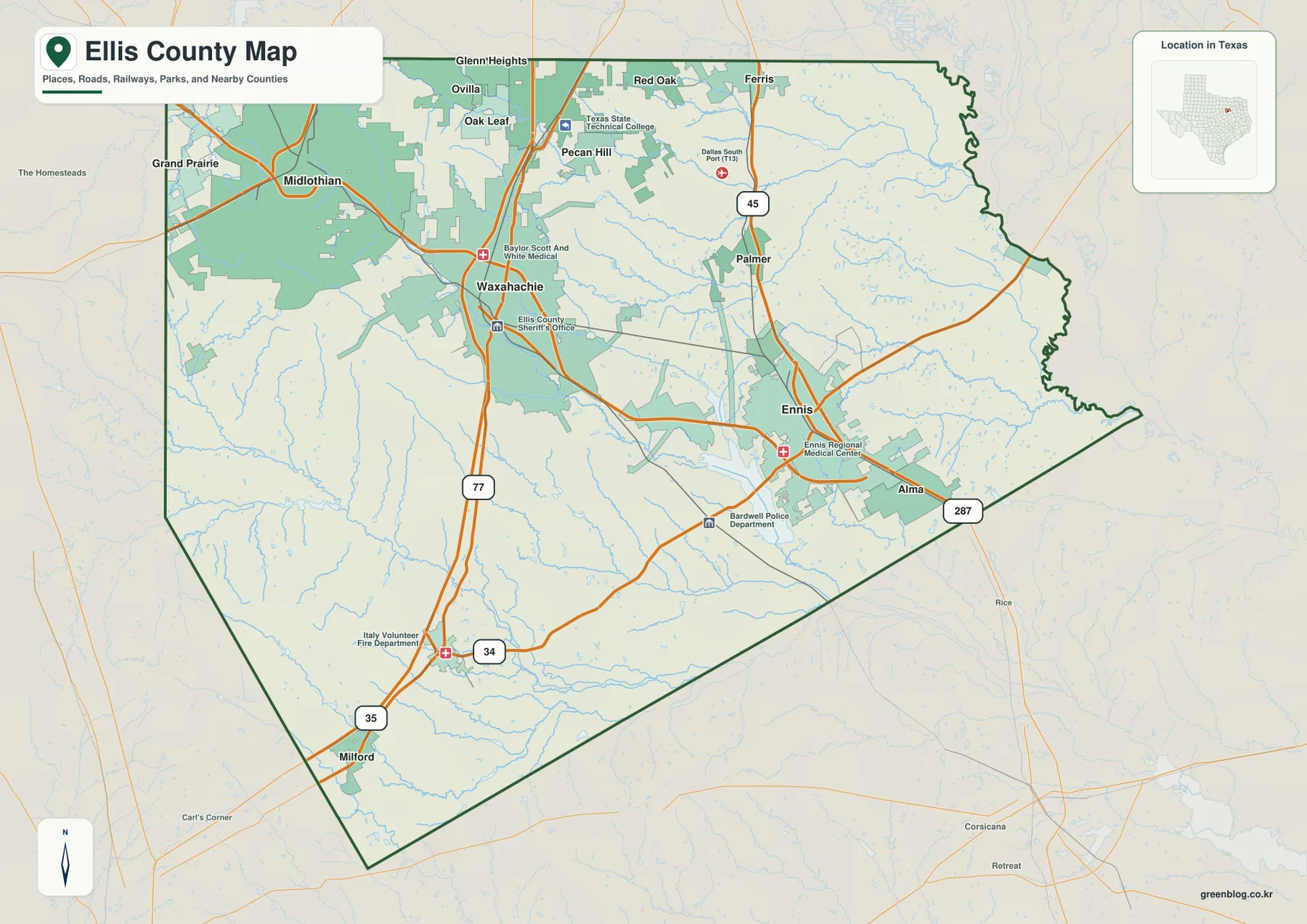
Ellis County sits immediately south of the Dallas area, but the county map does not show one continuous suburban strip. Waxahachie occupies the central-western part of the county, while Midlothian lies to the northwest, Red Oak and Glenn Heights are farther north, Ennis is east of the county seat, and Milford and Italy sit well to the south. The road pattern is just as divided: I-35E and the US 77 corridor run through the Waxahachie side, I-45 follows the Ferris–Palmer–Ennis side, and US 287 crosses between the two. The A3 high-resolution JPG versions of the county, city, water, and elevation maps shown on this page are available together in the download ZIP below.
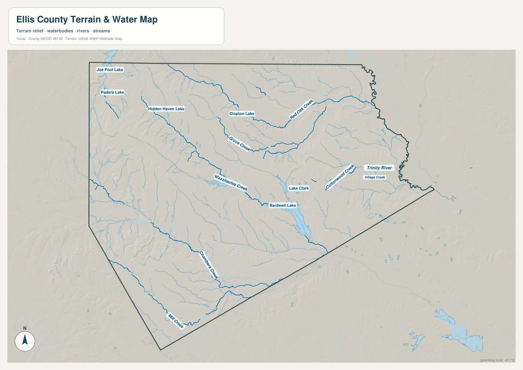
The county becomes more distinctive when the water and relief maps are added. Waxahachie Creek crosses the central-southern area toward Bardwell Lake, Red Oak Creek and Grove Creek drain the northern half, and Cottonwood Creek and Village Creek appear closer to the Trinity River side in the east. The elevation map shows higher ridges in the west and southwest, with a broad drop toward the greener eastern lowlands. Rather than treating each map as a separate product, it is more useful to follow the same place from roads to settlements, then to nearby water and elevation. That comparison reveals why Waxahachie, Ennis, Midlothian, and the southern communities do not all sit in the same kind of terrain.
Table of Contents
Two north-south corridors meet across Waxahachie and Ennis
Waxahachie is the easiest place to orient the general county map. The county seat marker is close to the I-35E and US 77 north-south route, while US 287 approaches from the Midlothian side and continues east toward Ennis. South of Waxahachie, the same western corridor continues toward Italy and Milford. SH 34 crosses the southern half of the county and provides another east-west reference near Italy. North of Waxahachie, Red Oak and Glenn Heights are positioned closer to the Dallas-facing end of the corridor, while Midlothian sits farther west and is separated from the I-35E line by a wider developed and open-land area.
Ennis is organized around a different main route. I-45 runs through Ferris, Palmer, and Ennis on the eastern side, and US 287 reaches Ennis from Waxahachie before continuing southeast. The map therefore shows two strong north-south travel lines rather than a single county spine. Waxahachie is tied closely to I-35E and US 287, while Ennis is tied to I-45 and US 287. Looking at the two cities together makes the county’s shape easier to understand: the western corridor connects toward Dallas through Red Oak, the eastern corridor connects through Palmer and Ferris, and US 287 provides the cross-county link between major centers.
Major cities cluster in the north and center, then spread out southward
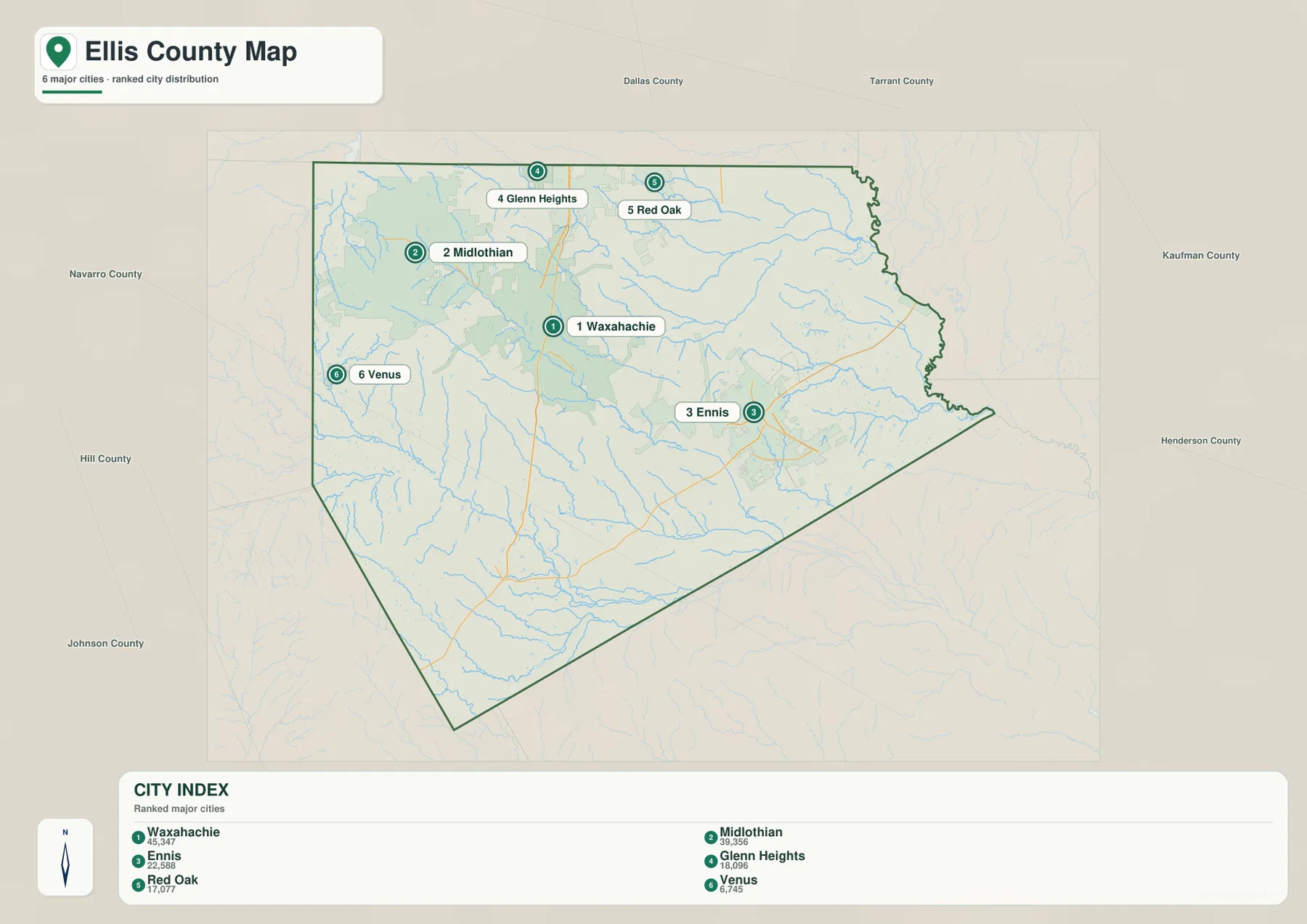
The city index simplifies Ellis County to six ranked places: Waxahachie 45,347; Midlothian 39,356; Ennis 22,588; Glenn Heights 18,096; Red Oak 17,077; and Venus 6,745. The geographic pattern matters as much as the ranking. Waxahachie and Ennis form two major centers across the middle of the county. Midlothian, Glenn Heights, and Red Oak sit in the northern half, where the county approaches the larger Dallas urban area. Venus is farther west, near the edge of the county, and is more isolated on this simplified city view.
The general county map adds places that do not appear in the six-city ranking, including Palmer, Ferris, Italy, Milford, and Alma. Those smaller labels are important because they fill the gaps between the ranked cities. Palmer and Ferris extend the I-45 settlement line north of Ennis, while Italy and Milford show how the populated pattern continues through the south even as distances between communities become wider. For a quick comparison of the largest places, the city index is the cleaner map. For actual road relationships and smaller settlement locations, the general county map provides the necessary detail.
Bardwell Lake anchors a creek network across the middle of the county
Bardwell Lake is the clearest water feature in the central-southern portion of the water map. Waxahachie Creek approaches the lake from the west, while Lake Clark is marked a short distance to the northeast. When the water map is compared with the road map, Bardwell Lake sits southwest of Ennis and south of the main Waxahachie–Ennis connection. That makes the reservoir a useful landmark for locating the middle of the county even when road labels are removed.
The rest of the drainage network is more distributed. Red Oak Creek and Grove Creek cross the northern half, and the northwestern edge includes Joe Pool Lake along with several smaller named lakes. Cottonwood Creek and Village Creek appear farther east near the Trinity River side, while Chambers Creek and Mill Creek define long drainage lines in the south. These streams are not arranged as one simple trunk with short branches. Instead, the map shows multiple creek systems cutting through different parts of the county, which helps explain the dense branching texture visible on the elevation map.
Western ridges stand above the lower eastern drainage country
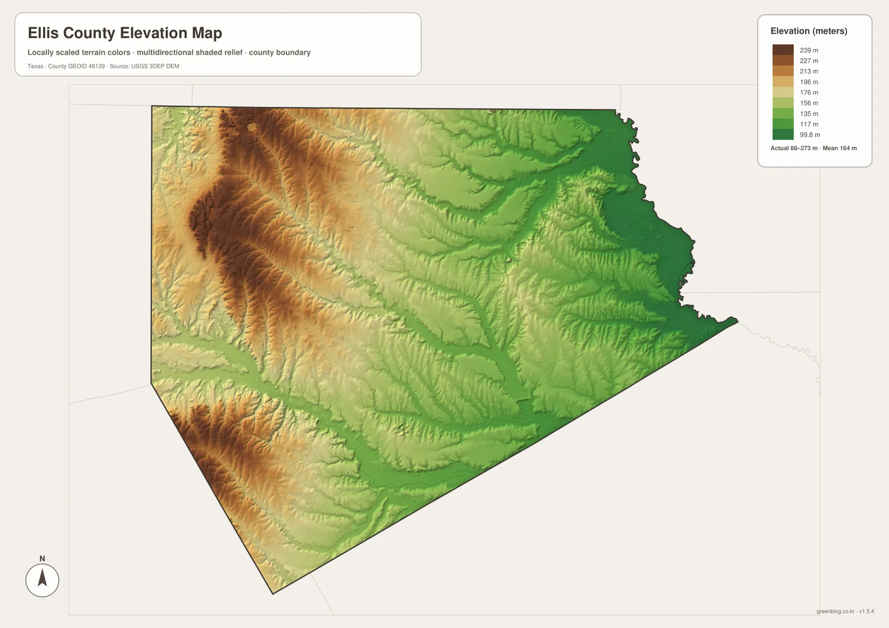
The elevation map lists an actual county range of roughly 88 to 273 meters, with a mean near 164 meters. The highest brown and orange terrain is concentrated in the west and southwest, with another prominent high ridge in the northwest. Elevation decreases through yellow and light-green bands toward the center, and the eastern and northeastern portions are dominated by lower green shades. The surface is not a smooth ramp from west to east. Narrow valleys repeatedly cut into the higher ground, producing long branching low areas that correspond closely with the creek network.
Several comparisons become clearer when the elevation and water maps are viewed together. The Red Oak Creek and Grove Creek valleys occupy lower strips within the northern terrain. Waxahachie Creek and the Bardwell Lake basin also sit below the higher western ridges, and the eastern Trinity River side is among the broadest low areas on the map. Midlothian’s side of the county is closer to the higher western terrain, while Ennis lies in a generally lower eastern setting. The elevation map is therefore useful not just for finding the highest point colors, but for seeing how creek valleys break up the county between its larger cities and road corridors.
A practical way to compare the same place across all map views
Waxahachie is a good first test point. On the general map, locate the I-35E/US 77 corridor and US 287. On the city map, note that Waxahachie is ranked first among the six highlighted cities. Then move to the water map and find Waxahachie Creek south and east of the city area. Finally, check the elevation map and compare that creek corridor with the higher western ridges. In four steps, the county seat changes from a simple label into a place defined by a road junction, a nearby drainage line, and a transition between higher and lower terrain.
Ennis provides a different comparison. It is tied to I-45 and US 287 rather than the I-35E line, and the city map places it east of Waxahachie. Bardwell Lake appears to the southwest on the water map, while Cottonwood Creek and Village Creek are farther east. The elevation map shows the Ennis side in generally lower green terrain than the western ridges near Midlothian. If the goal is to understand road access, start with the general map. If the goal is settlement scale, use the city index. For drainage and reservoir position, use the water map, and for the broader west-to-east terrain contrast, use the elevation map.
Frequently Asked Questions
Which roads are the easiest references for Waxahachie and Ennis?
Waxahachie is easiest to find near the I-35E/US 77 corridor and US 287. Ennis is on the eastern I-45 corridor, where US 287 also passes through the city area. The general county map is the best view for comparing the two road systems at once.
Where is Bardwell Lake on the Ellis County maps?
Bardwell Lake is shown in the central-southern part of the county, southwest of Ennis. Waxahachie Creek approaches the reservoir from the west, so the creek and Ennis together make useful reference points for finding the lake.
Which parts of Ellis County are highest and lowest on the elevation map?
The highest terrain is concentrated in the west and southwest, with another strong ridge in the northwest. Lower green terrain spreads across much of the east and northeast. The map lists an actual elevation range of about 88 to 273 meters and a mean near 164 meters.
Sources and reference data
These official resources are useful for checking the boundary, hydrography, and elevation data families behind the map layers.
- USGS The National Map Viewer — an official viewer for U.S. terrain, hydrography, and other geographic layers.
- U.S. Census Bureau TIGER/Line Shapefiles — official county and administrative boundary data.
- USGS National Hydrography — national stream, river, lake, and other hydrography information.
- USGS 3D Elevation Program — official elevation data and 3DEP information.
Map File Information
The A3 high-resolution JPG files matching the Ellis County maps shown in this article are packaged together in one ZIP.
- File Type: JPG
Related Maps
- Navarro County Texas map
- Rockwall County Texas map
- Tarrant County Texas map
- Roberts County Texas map
- Wheeler County Texas map
Green Map creates custom-edited map images using open geographic data sources such as geoBoundaries, Natural Earth, OpenStreetMap, and government open data.
These maps are edited visual materials, not raw data files, and are provided for education, documents, presentations, and graphic reference.