This page uses Shamrock as the southern hub for a Wheeler County Texas Map, then follows US 83 north to Wheeler and northwest toward Mobeetie. Download the high-resolution A3 JPG map ZIP from the box below when you need printable or editable files; it contains separate county-reference, city-connections, terrain-and-water, and elevation maps.
Wheeler County becomes easier to understand when the three main mapped communities are treated as separate directional references. Shamrock lies along the southern Interstate 40 corridor, Wheeler is near the center, and Mobeetie is farther northwest. Allison appears near the northern edge on the full county map. The water and elevation layers show a second pattern beneath the roads: higher western terrain drains eastward through Sweetwater Creek and southward through the North Fork Red River system into much lower eastern and southeastern ground.
Table of Contents
Shamrock links Interstate 40 with the northbound US 83 corridor
Shamrock is the easiest starting point on the county reference map. Interstate 40 crosses the southern edge, route 66 follows the same broad east-west corridor, and US 83 turns north from the Shamrock area toward Wheeler. This makes the southern city useful for understanding both long-distance east-west travel and the main northbound route into the middle of the county.
Wheeler sits farther north where route 152 crosses the county from west to east. Route 48 continues north, while Mobeetie is positioned northwest of Wheeler along the western road network. Allison appears near the northern county edge. Route 556 is labeled near Shamrock, and route 30 appears near the southeastern side, adding smaller references once the main Shamrock–Wheeler corridor is clear.
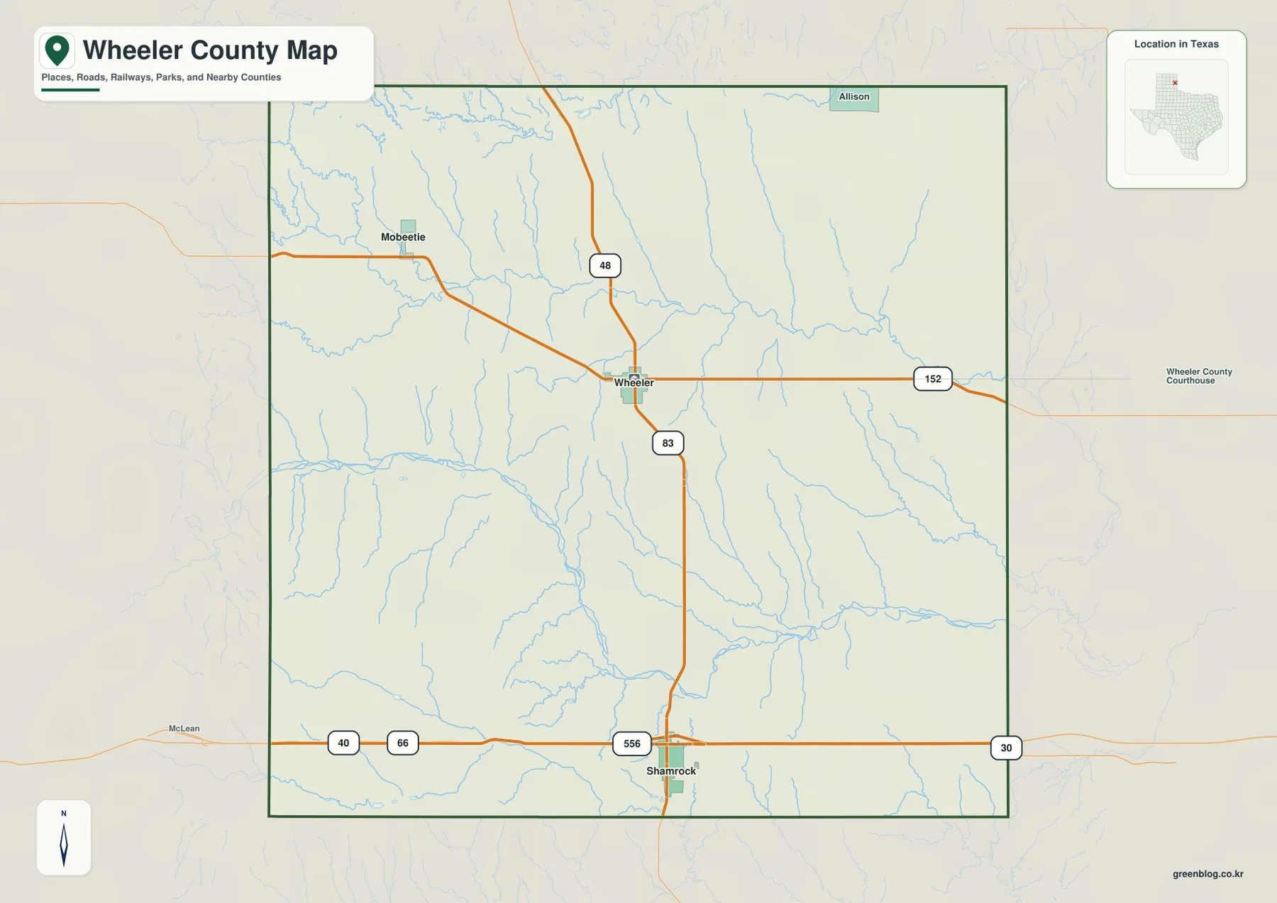
Streams fill much of the open space between the roads. Branching channels are especially noticeable across the center and south, and northern creeks descend from higher western ground toward the east. The reference map therefore shows more than isolated towns on open plains; it also hints at the repeated ridges and shallow valleys that become obvious on the terrain and elevation layers.
Wheeler is about 16 miles from Shamrock, Mobeetie about 24
The city-connections map uses Shamrock as the hub and prints direct distances to Wheeler and Mobeetie. Wheeler is about 16 miles from Shamrock, while Mobeetie is about 24 miles away. These are straight-line distances between mapped city points rather than driving mileages, so the actual road distance will depend on the chosen route and exact start and end locations.
The CITY CONNECTIONS panel shows map values of 1,710 for Shamrock, 1,431 for Wheeler, and 64 for Mobeetie. Those figures explain the ranking and relative display used in the supplied graphic and should not be treated as guaranteed current population estimates. For geographic reading, the useful point is the spacing: Wheeler is the closer northbound connection from Shamrock, while Mobeetie lies farther northwest and much farther from the southern highway corridor.
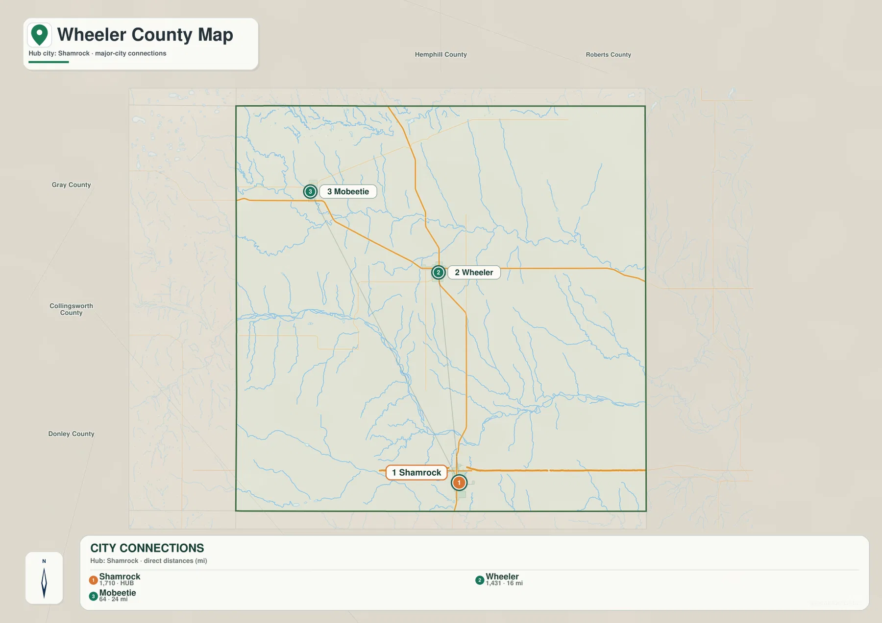
County labels around the map help explain the position of those communities. Hemphill and Roberts counties are north of Wheeler County, while Gray, Collingsworth, and Donley counties appear to the west and southwest. With that frame visible, Mobeetie’s northwestern location and Shamrock’s near-southern position become much easier to recognize.
Sweetwater Creek and North Fork Red River define the main drainage corridors
Sweetwater Creek is one of the clearest named waterways across the northern half of the terrain-and-water map. It enters from the west and continues eastward through the county, receiving smaller tributaries along the way. Adobe Creek and Graham Creek join the western side, while Goodin Creek and Coburn Creek descend through the north-central interior toward the larger channel.
The North Fork Red River is the dominant southern waterway. It enters from the west, bends across the south-central part of the county, and continues east. Bronco Creek and an East Branch feed the river from the north, while Salt Creek occupies another large eastern valley. North Long Dry Creek and South Long Dry Creek divide the southwestern interior into additional lower corridors.
Gageby Creek forms another long northern reference, and Little Hackberry Creek is labeled farther west. Lake Loraine appears near the southwestern edge as a small named water body. Wheeler County is therefore not organized around one large lake; its terrain is better understood through the long creek valleys and the North Fork Red River crossing the southern half.
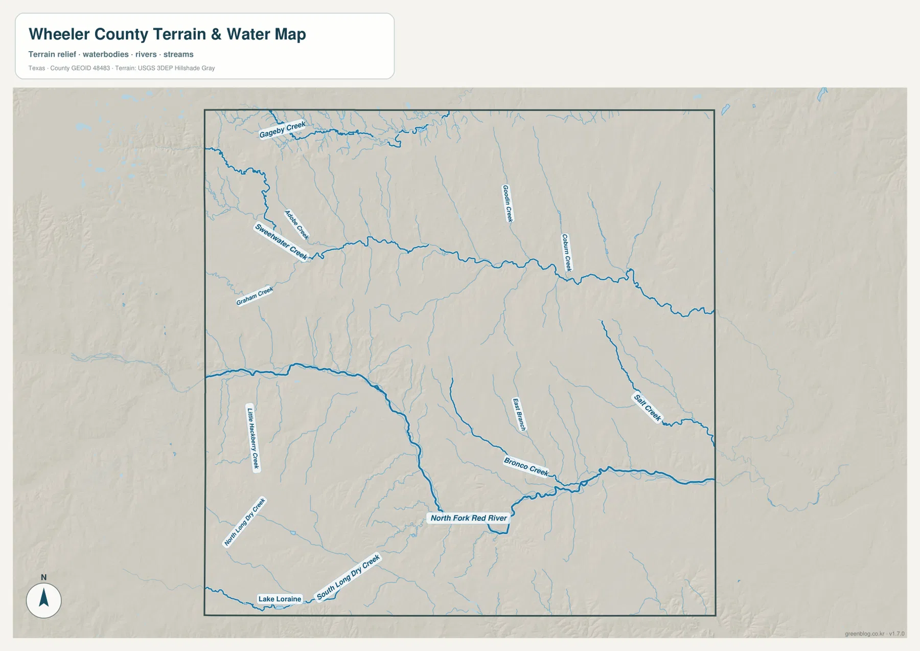
This layer is intended for geographic water and terrain reference rather than flood-risk analysis, navigation, water depth, parcel boundaries, or water-management decisions. Its main value here is to show how Sweetwater Creek shapes the northern half, how the North Fork Red River cuts across the south, and how smaller tributaries descend into those lower corridors.
Western uplands stand well above the eastern river lowlands
The elevation map reports an actual range of about 595 to 915 meters and a mean elevation of 747 meters. The darkest brown high ground covers much of the northwest and western edge, with additional high terrain in the southwest. The eastern half shifts through yellow-green into broad green lowlands, and the southeastern corner is among the lowest areas on the map.
Sweetwater Creek creates a long lower valley across the north-central interior, while the North Fork Red River forms a much broader low corridor through the southern half. Numerous smaller tributaries cut into the western uplands and descend toward those major valleys. The result is a clear west-to-east decrease in elevation, but with local ridges and creek-cut valleys preventing the county from appearing as one simple uniform slope.
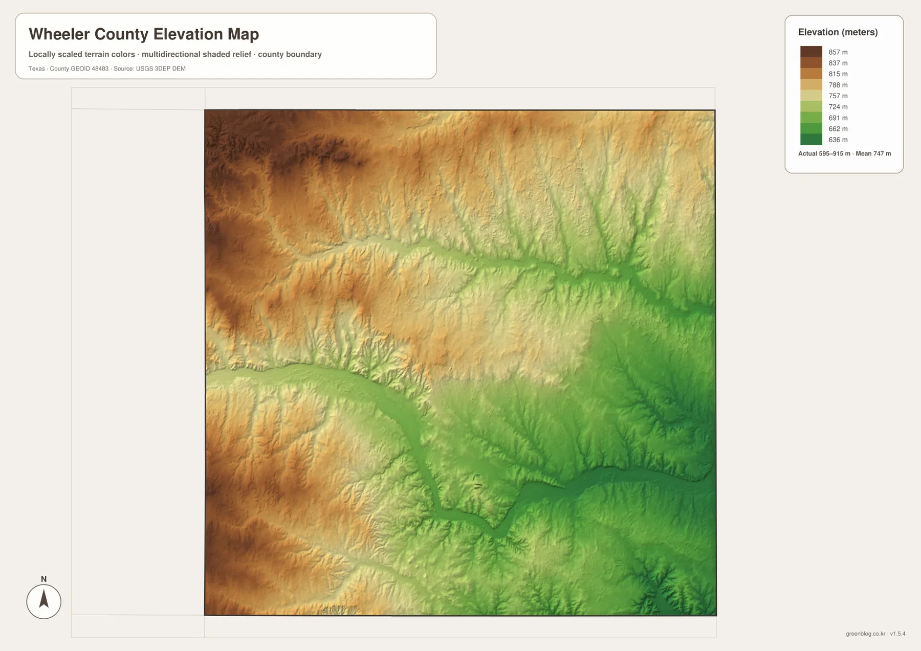
This countywide elevation surface is designed for broad terrain comparison rather than parcel surveying, engineering, or construction design. It is useful for seeing where the western terrain rises, why the major creek and river valleys appear lower, and how the county descends toward the east and southeast. Exact site elevation should be checked with detailed source data or a local survey.
Choose the view by whether highways, town spacing, waterways, or relief matters most
Use the county reference map when Shamrock, Wheeler, Mobeetie, Allison, road labels, and the county boundary need to appear together. The city-connections view is cleaner for comparing direct spacing from Shamrock to Wheeler and Mobeetie. The terrain-and-water layer is the best place to trace Sweetwater Creek, North Fork Red River, Salt Creek, and Lake Loraine, while the elevation map makes the western uplands and lower eastern terrain easiest to compare.
The downloadable ZIP contains four separate high-resolution A3 JPG files for Wheeler County: county reference, city connections, terrain and water, and elevation. You can inspect the lighter WebP versions in the article first and then use the larger JPG files for printing, classroom material, presentations, or an editable local-reference document.
Frequently Asked Questions
How far are Wheeler and Mobeetie from Shamrock on the city map?
The supplied city-connections map shows Wheeler about 16 miles from Shamrock and Mobeetie about 24 miles away by straight-line distance. Driving mileage will vary with the route.
Which waterways are easiest to identify in Wheeler County?
The North Fork Red River is the strongest southern water reference, while Sweetwater Creek crosses the northern half. Gageby Creek, Goodin Creek, Salt Creek, Bronco Creek, and Lake Loraine are also labeled.
What elevation range is shown for Wheeler County?
The supplied elevation map states an actual range of about 595 to 915 meters and a mean elevation of 747 meters. The west and northwest are higher, while the east and southeast are lower.
Map File Information
The ZIP contains the four Wheeler County maps in high-resolution A3 JPG format.
- Included Versions: County reference, city connections, terrain and water, elevation
- Included Files: 4 A3 JPG maps
Related Maps
Sources and data references
Roads, settlement locations, and the Wheeler County boundary can be cross-checked with the U.S. Census Bureau TIGER/Line Shapefiles. North Fork Red River, Sweetwater Creek, and other named drainage features can be checked against USGS National Hydrography, while terrain height data are available through the USGS 3D Elevation Program. City-connection values, direct distances, named waters, and the 595–915 meter elevation range described above are based on the Wheeler County maps supplied in this package.
Green Map creates custom-edited map images using open geographic data sources such as geoBoundaries, Natural Earth, OpenStreetMap, and government open data.
These maps are edited visual materials, not raw data files, and are provided for education, documents, presentations, and graphic reference.