This Stephens County Texas Map set is built around Breckenridge, the large Hubbard Creek Reservoir to the west, the Clear Fork Brazos River along the north, and a rugged belt of higher terrain in the south and southeast. Download the high-resolution A3 JPG map ZIP from the box below when you need files for printing or editing; it contains the county-reference, city, terrain-and-water, and elevation maps used in this article.
Stephens County does not read like a map dominated by several large towns. Breckenridge is the single major city reference, while roads and creek valleys spread outward across a mostly rural interior. The broad reservoir gives the western side an immediate landmark, and the northern river corridor contrasts with the higher dissected ridges farther south. Looking at those relationships together makes the county easier to understand than treating roads, water, and relief as separate subjects.
Table of Contents
Breckenridge organizes the road network in the middle of the county
Breckenridge is the strongest anchor on the general reference map. An east-west route crosses the city and continues toward the U.S. 180 shield shown on the eastern side. Route labels 176, 67, and 179 cluster close to Breckenridge, while 576 and 183 extend southward. Instead of reading every number independently, it is easier to start at Breckenridge and follow the roads toward the county edges.
Crystal Falls is marked to the north, with 578 and 287 visible in the same general part of the map. Route 701 runs northeast from the central area, and the eastern side includes 33, 252, and 180. Eureka appears near the southwest edge and Bullock near the southeast. These smaller labels help establish direction without turning the map into a long place-name list, and they show how far Breckenridge sits from the outer parts of the county.
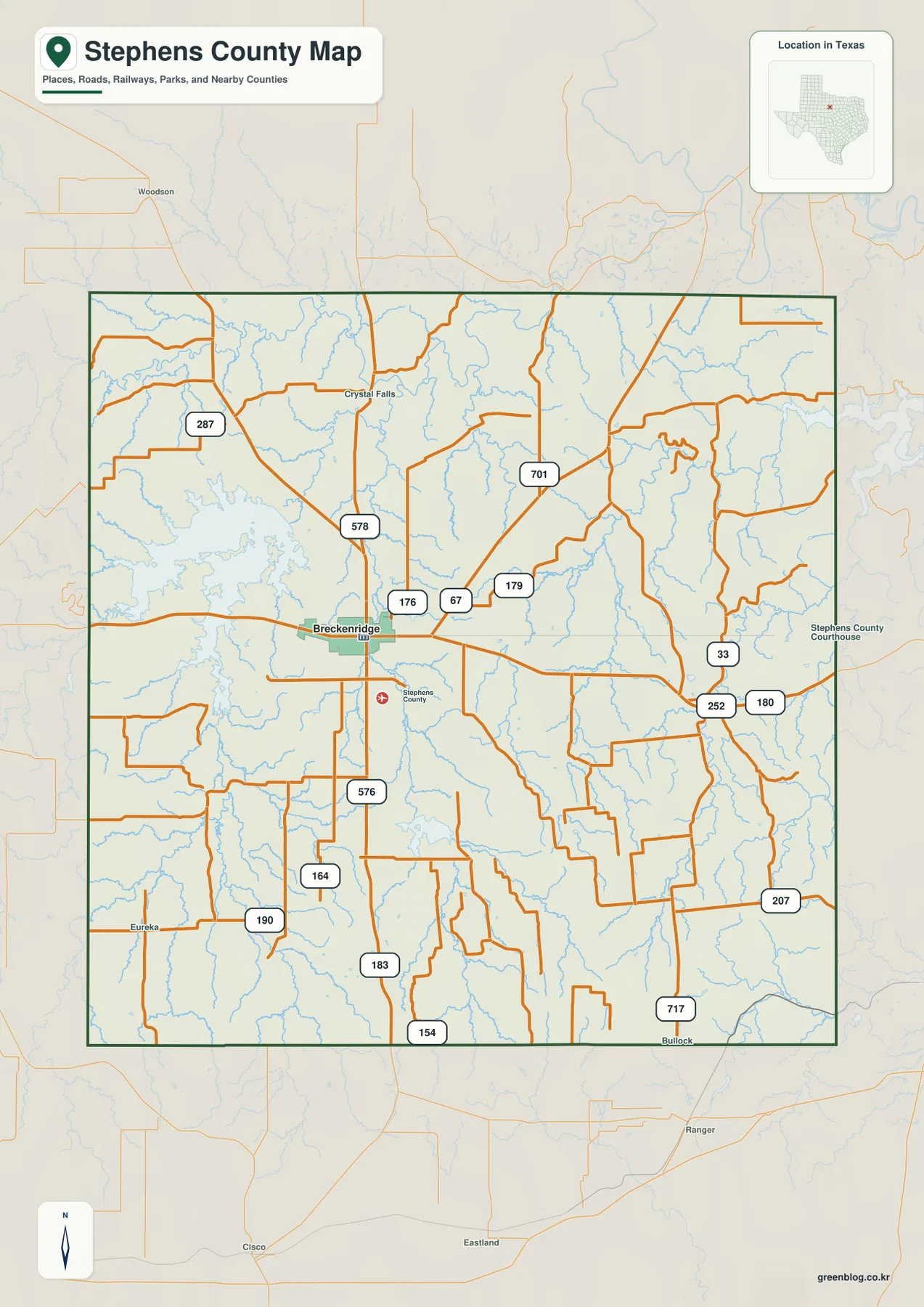
The blue drainage lines are nearly as important visually as the roads. Creeks cut across the eastern and southern parts of the county and force the road network to cross a series of valleys. In the north, a larger river corridor bends near the county edge. The reference map therefore works well for orientation, but the terrain-and-water and elevation maps explain the physical setting behind those road patterns.
The city view reduces Stephens County to one clear settlement reference
The ranked city map highlights only Breckenridge. With most secondary labels and road details removed, the city stands out slightly west of the county’s center, surrounded by thin streams and a few pale road lines. That simplified presentation is useful when the goal is to show the county’s principal mapped city without the visual competition of the full reference layer.
The CITY INDEX prints Breckenridge at 5,170. That number is the value used by the supplied map for its city ranking and should not be treated as a guaranteed current population estimate. A project that needs the latest demographic total should check an official statistical source. For this map, the important point is that Breckenridge is the only ranked major city and serves as the location anchor for the rest of the county.
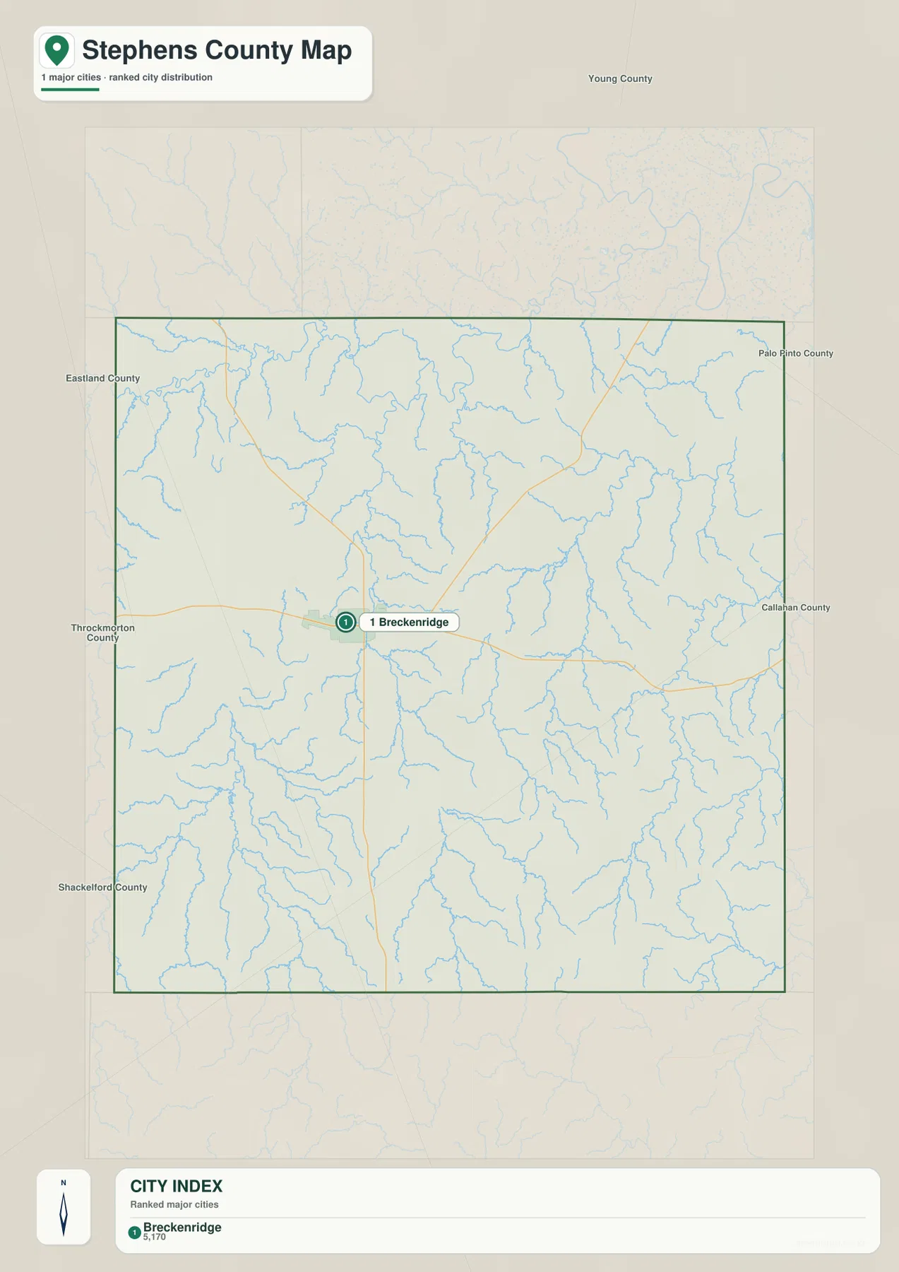
This version works well for a classroom map, local overview, or presentation that needs one unmistakable settlement reference. Once Breckenridge is fixed in place, the reservoir to the west, river corridor to the north, and high ridges to the southeast are easier to locate on the more detailed maps that follow.
Hubbard Creek Reservoir and the Clear Fork Brazos define the largest water features
The terrain-and-water map is dominated by Hubbard Creek Reservoir on the western side. Its broad irregular shoreline is very different from the narrow creek channels elsewhere in the county. Along the north, the Clear Fork Brazos River follows a wide bending course, while Gonzales Creek runs south from the river area into the central interior. Cedar Creek forms another strong drainage reference farther east.
Several smaller lakes help divide the interior into recognizable sections. Grand Lake appears near the center, Conner Lake is farther west, and Lake Daniel sits to the south. Lake Necessity and T P Lake are labeled in the southeast and east-central area. Caddo Creek follows a longer drainage line in the east, while Big Sandy Creek runs through the southwest. These features show that the county’s water geography is not limited to one reservoir and one river; many smaller valleys cross the uplands between them.
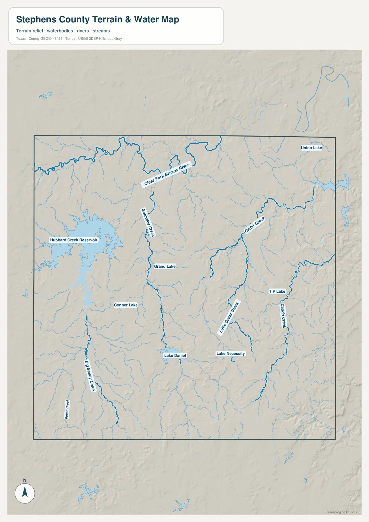
A useful reading order is to locate the western reservoir and northern river first, then trace the creek valleys between them and the southern county line. This layer is a geographic reference for water and terrain relationships. It is not a flood-hazard map, parcel-boundary product, navigation chart, or substitute for detailed water-management information.
High southern ridges contrast with the lower northern river corridor
The elevation map reports an actual range of about 304 to 497 meters and a mean elevation of 390 meters. Brown and orange terrain is concentrated in the south and southeast, where broad high ridges are cut by narrow valleys. The northern and northeastern portions are much greener, indicating lower land associated with the Clear Fork Brazos River and its tributary corridors.
The relief is not a single smooth slope from south to north. Higher surfaces are repeatedly broken by creek valleys, and the central and western parts contain a mixture of green, yellow, and tan terrain. Comparing this map with the water layer makes the pattern much easier to see: Cedar Creek, Caddo Creek, Big Sandy Creek, and other streams generally occupy lower corridors between the surrounding ridges.
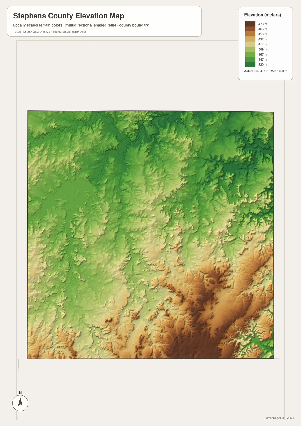
This countywide elevation surface is intended for broad terrain comparison rather than parcel surveying or engineering design. It is useful for seeing where the higher ridges are concentrated, how creek valleys cut through them, and how the land around Breckenridge differs from the southeast. Exact elevation for a site or structure should be checked with detailed source data or a local survey.
Frequently Asked Questions
Where is Hubbard Creek Reservoir relative to Breckenridge?
On the supplied terrain-and-water map, Hubbard Creek Reservoir lies west of Breckenridge. Its broad shoreline makes it the most obvious water body on the western side of Stephens County.
Where does the Clear Fork Brazos River appear on the map?
The Clear Fork Brazos River bends across the northern part of the terrain-and-water map. Gonzales Creek and several smaller tributaries occupy lower valleys extending away from that northern river corridor.
Which part of Stephens County is highest?
The elevation map places the strongest brown high-elevation colors in the south and southeast. The actual mapped range is about 304 to 497 meters, with a mean elevation of 390 meters.
Map File Information
Download the map files associated with this page for reference, printing, and compatible visual projects.
- Included Files: Use only the versions confirmed in the article and supplied images
- File Type: Use the confirmed download contents
- Intended Use: Printing, education, presentations, and map-based projects
Related Maps
Sources and data references
Roads and county boundaries around Breckenridge can be cross-checked with the U.S. Census Bureau TIGER/Line Shapefiles. Hubbard Creek Reservoir, the Clear Fork Brazos River, creeks, and lake names can be checked against USGS National Hydrography, while terrain height data are available through the USGS 3D Elevation Program. Route labels, named waters, and the 304–497 meter elevation range described above are based on the Stephens County maps supplied in this package.
Green Map creates custom-edited map images using open geographic data sources such as geoBoundaries, Natural Earth, OpenStreetMap, and government open data.
These maps are edited visual materials, not raw data files, and are provided for education, documents, presentations, and graphic reference.