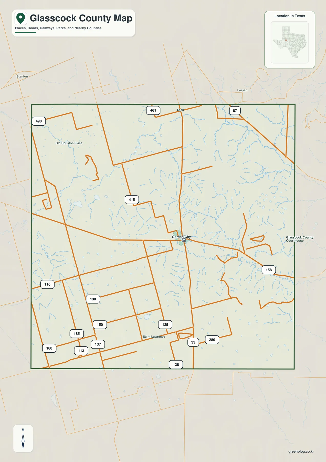
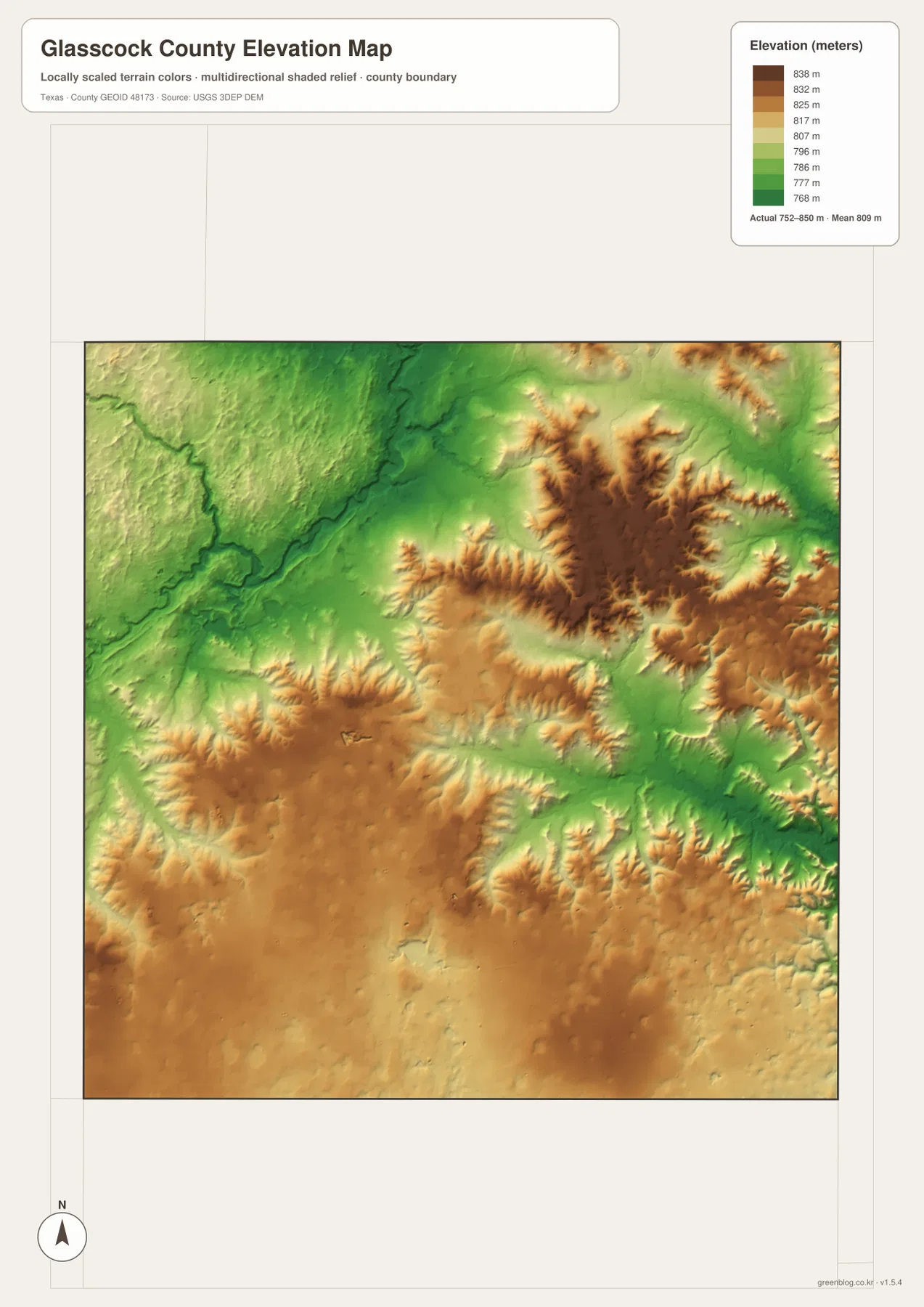
Download high-resolution A3 JPG maps of Glasscock County, Texas from the ZIP box on this page, including the county, water, and elevation views supplied with this package. Garden City is the clearest location reference on the road map, with Route 158 running east and Route 33 continuing south, while a larger web of numbered local roads spreads toward Lees, Saint Lawrence, and the western side of the county. The water map adds North Concho River, Panther Creek, Polecat Creek, several forks of Apple Creek, Lacy Creek, and Currie Reservoir. The elevation map ranges from about 752 to 850 meters and shows a county made up of rolling high ground broken by lower drainage corridors rather than a single uniform surface.
The map set is especially useful because the road and terrain patterns look very different. Roads west and south of Garden City often form long straight segments and right-angle turns, while the creek network branches and bends across the same space. Lees is labeled near the northern boundary, Saint Lawrence appears in the south-central area, and Old Houston Place provides another reference in the northwest. Starting with those labels on the county map and then switching to the water and elevation views makes the internal geography much easier to follow.
Table of Contents
Garden City and the Numbered Road Network
Garden City sits near the middle of the county map and functions as the most practical orientation point. Route 158 continues east from the Garden City area, while Route 33 runs south through the lower half of the county. North of town, a long road reaches toward the upper boundary, where Routes 461 and 87 are visible. Once those main lines are located, the smaller numbered roads become easier to place within the square county outline.
The western and southwestern sections contain a dense set of numbered roads, including 415, 110, 130, 150, 185, and 180. Farther south, Routes 125, 137, 113, and 138 add additional local connections. Many of these road segments are notably straight, giving the western half a simple geometric appearance that contrasts with the winding blue drainage lines beneath them. Saint Lawrence provides a useful place label in the south-central area, while Old Houston Place helps orient the northwest.
Lees is labeled close to the northern boundary, with Route 87 appearing farther east along the top portion of the map. The preview also shows outside place names such as Stanton and Forsan, but this article does not use those outer labels as the basis for detailed directional claims. The internal county features are enough to establish orientation: find Garden City, then use Lees to the north and Saint Lawrence to the south before following the numbered roads toward the edges.
North Concho River and the Apple Creek Drainage
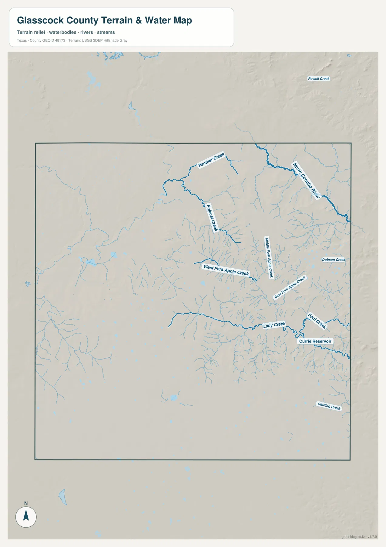
North Concho River is one of the strongest named water features in the northeast. It crosses the upper-right part of the county on a diagonal course and receives smaller drainage lines from the surrounding terrain. Panther Creek appears farther west in the northern interior, and Polecat Creek runs through the upper-central portion of the map. These larger labels provide a useful framework before the numerous thinner tributaries are considered.
The central and eastern interior is organized around several Apple Creek branches. West Fork Apple Creek extends from the west toward the middle, Middle Fork Apple Creek occupies a nearby north-south valley, and East Fork Apple Creek is labeled farther east. Their names and positions make the middle of the water map easier to interpret because they separate a complicated drainage area into three recognizable channels.
Lacy Creek crosses the eastern half farther south, with Fool Creek nearby and Currie Reservoir labeled close to their drainage. Dobson Creek appears in the eastern interior as another named reference. The result is a water map with a stronger concentration of labeled creeks and reservoir features on the east side, while the western half contains many smaller, less prominently named drainage lines.
This map is designed for locating rivers, creeks, and a reservoir relative to the county terrain. A blue line does not establish permanent flow, channel depth, flood risk, legal shoreline limits, or navigability. Its practical value is geographic: Garden City can be used as the road reference, North Concho River as the northeastern water reference, and the Apple Creek and Lacy Creek systems as guides through the central and eastern valleys.
Rolling High Ground and Lower Creek Valleys from 752 to 850 Meters
The elevation map lists an actual Glasscock County range of about 752 to 850 meters and a mean near 809 meters. Brown and tan high ground appears in several separate areas rather than one continuous block, including a strong north-central upland and broad higher terrain through parts of the south and southwest. Green low areas cut through the county along drainage corridors, especially in the northwest and across portions of the central and eastern interior.
The roughly 100-meter difference between the mapped low and high points is modest compared with mountain counties, but the relief pattern is still visually complex. Narrow valleys split the higher surfaces into ridges and rounded uplands. In the north, green channels descend between higher areas; farther east, lower corridors widen where the creek network becomes denser. The county therefore looks more dissected on the elevation map than it does on the road map.
Comparing the water and elevation views helps connect the labels to the terrain. Polecat Creek and the Apple Creek branches occupy lower corridors, and Lacy Creek follows another low path farther south and east. Higher ground remains between the drainage lines, particularly across portions of the south and the north-central interior. This relationship is more useful than assigning the whole county a single high-or-low direction because the relief is divided among multiple local ridges and valleys.
The color surface is intended for broad county-scale comparison. It should not be used as survey-grade elevation for a parcel, road grade, engineering project, or construction decision. For ordinary map reading, however, the 752–850 meter range is enough to show where streams have cut lower paths through the higher surrounding terrain.
Reading the County West and East of Garden City
West of Garden City, the county map emphasizes roads more strongly than named waterways. Routes 415, 110, 130, 150, and other local roads spread across broad spaces, while the elevation view shows higher terrain interrupted by numerous small drainage cuts. This part of the county is easier to understand by establishing the road grid first and then using the elevation map to see where those roads cross ridges or shallow valleys.
East and northeast of Garden City, named water features become much more prominent. Polecat Creek, the Apple Creek forks, Lacy Creek, Fool Creek, Currie Reservoir, and North Concho River create a chain of useful references across the eastern half. The settlement pattern does not suddenly become denser, but the water and terrain labels do. That difference is why a Glasscock County map is more informative when roads, hydrography, and elevation are compared rather than when the county is described only through a broad regional label.
Choosing the Map for Roads, Water, or Elevation
Use the county map when you need Garden City, Lees, Saint Lawrence, Route 158, Route 33, and the wider numbered road network in one view. The water map is the better choice for North Concho River, Panther Creek, Polecat Creek, the Apple Creek forks, Lacy Creek, and Currie Reservoir. Choose the elevation map when you want to compare the rolling higher ground with the lower drainage corridors. No city map is included in this package, so the article does not describe or imply a separate city-map asset.
The WebP images are convenient for viewing on the page, while the ZIP below contains the matching high-resolution A3 JPG originals for printing and larger displays. The archive contains the county, water, and elevation maps supplied for this page, so you can keep the complete set or use only the file needed for classroom work, a presentation, local reference, or a personal map collection.
Frequently Asked Questions
What is the easiest starting point on a Glasscock County map?
Garden City is the clearest starting point. Route 158 extends east from the area and Route 33 continues south, while Lees and Saint Lawrence provide useful northern and southern place references on the general county map.
Which waterways stand out on the supplied water map?
North Concho River is a strong northeastern reference, while Panther Creek, Polecat Creek, West Fork Apple Creek, Middle Fork Apple Creek, East Fork Apple Creek, and Lacy Creek help organize the central and eastern drainage. Currie Reservoir is also labeled in the east.
What elevation range is shown on the Glasscock County elevation map?
The supplied elevation map lists an actual range of about 752 to 850 meters and a mean near 809 meters. Higher terrain occurs in several separate uplands, while lower green corridors follow many of the creek valleys.
Sources and Reference Data
USGS The National Map Viewer — Official U.S. Geological Survey map service for roads, terrain, hydrography, and other geographic layers.
USGS National Hydrography — Official reference for rivers, creeks, reservoirs, and hydrographic data.
USGS 3D Elevation Program — U.S. Geological Survey program for elevation and terrain data.
U.S. Census Bureau TIGER/Line Shapefiles — Official source for county boundaries, roads, and related base geography.
Map File Information
Download the Glasscock County county map, water map, and elevation map as high-resolution A3 JPG files. The ZIP contains the original map files shown on this page.
- File Type: JPG
Related Maps
- Reagan County Texas map
- Sterling County Texas map
- Andrews County Texas map
- Upton County Texas map
- Scurry County Texas map
Green Map creates custom-edited map images using open geographic data sources such as geoBoundaries, Natural Earth, OpenStreetMap, and government open data.
These maps are edited visual materials, not raw data files, and are provided for education, documents, presentations, and graphic reference.