Download a ZIP containing four high-resolution A3 JPG files directly from this Chicot County Map page. The set includes a general county map, a city-connections map, a water map, and an elevation map, so you can review the smaller WebP previews first and then choose the file you need for print or closer inspection. Chicot County stretches along Arkansas’s southeastern edge, with the Mississippi River bending along the east, Lake Chicot beside Lake Village, Dermott near the northwestern end, and Eudora farther south.
The county makes more sense as a long north-to-south strip than as a compact block. Dermott, Lake Village, and Eudora form three useful reference points along that length. The western boundary contains several straighter sections, while the eastern side follows large river bends and cutoffs. Roads cross the flatter interior, but near the Mississippi the shapes of water, shoreline, and narrow pieces of land become just as important as the road network.
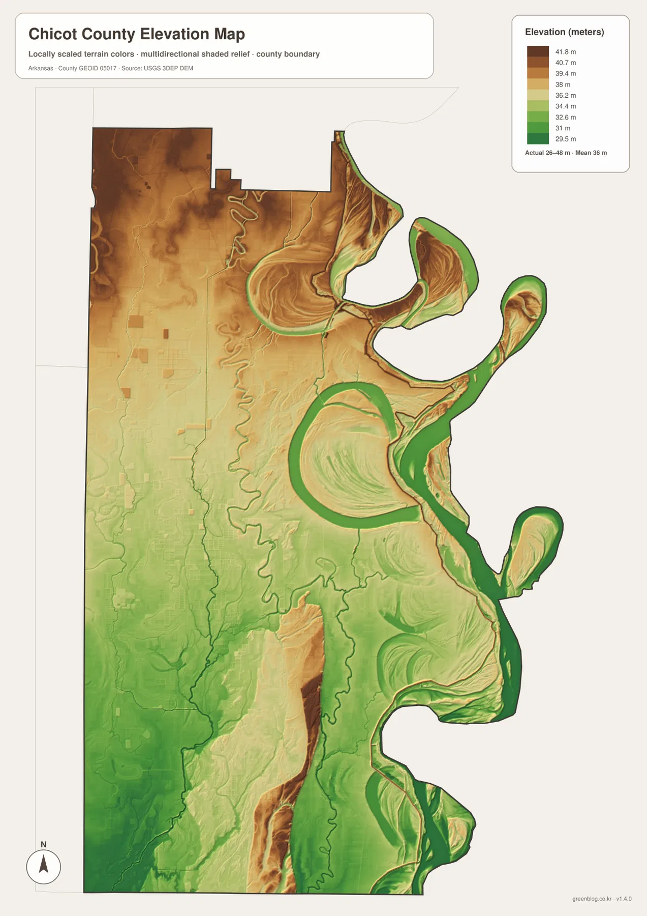
Relief is subtle rather than dramatic. The supplied elevation map ranges from about 26 to 48 meters, with a mean near 36 meters. A 22-meter total spread would barely register in a mountain county, but here it helps distinguish slightly higher ground from low floodplain surfaces, old river curves, bayous, and shallow drainage corridors. Reading the water and elevation maps together is therefore more useful than looking for hills that are not present.
Table of Contents
Use Lake Village as the main reference point
Lake Village is the easiest place to begin because several kinds of information meet there. It is the county seat, it lies beside Lake Chicot, and multiple numbered routes pass through or near the town. Routes 144 and 257 are easy to find around Lake Village, Route 82 bends toward the Mississippi side, and Route 160 continues south toward Eudora. Once Lake Village is located, the rest of the county can be read as a set of directions away from that center.
The general map adds more road detail than the city map. It labels routes including 165, 208, 35, 257, 144, 293, 82, 142, 160, 52, 65, 8, and 159. The point is not to memorize every number. Instead, the pattern shows where roads cluster near Dermott and Lake Village, how they continue south toward Eudora, and where the road network approaches the river side of the county. For current driving directions, closures, or travel times, a live navigation service is still the better source.
The county outline is also easiest to understand on this map. The west has comparatively straight boundary segments, while the east bends repeatedly with the Mississippi River. Lake Chicot creates another large curved shape beside Lake Village. Those features explain why Chicot County does not look like a simple rectangle even though much of its interior terrain is very flat.
Dermott, Lake Village, and Eudora stretch the county north to south
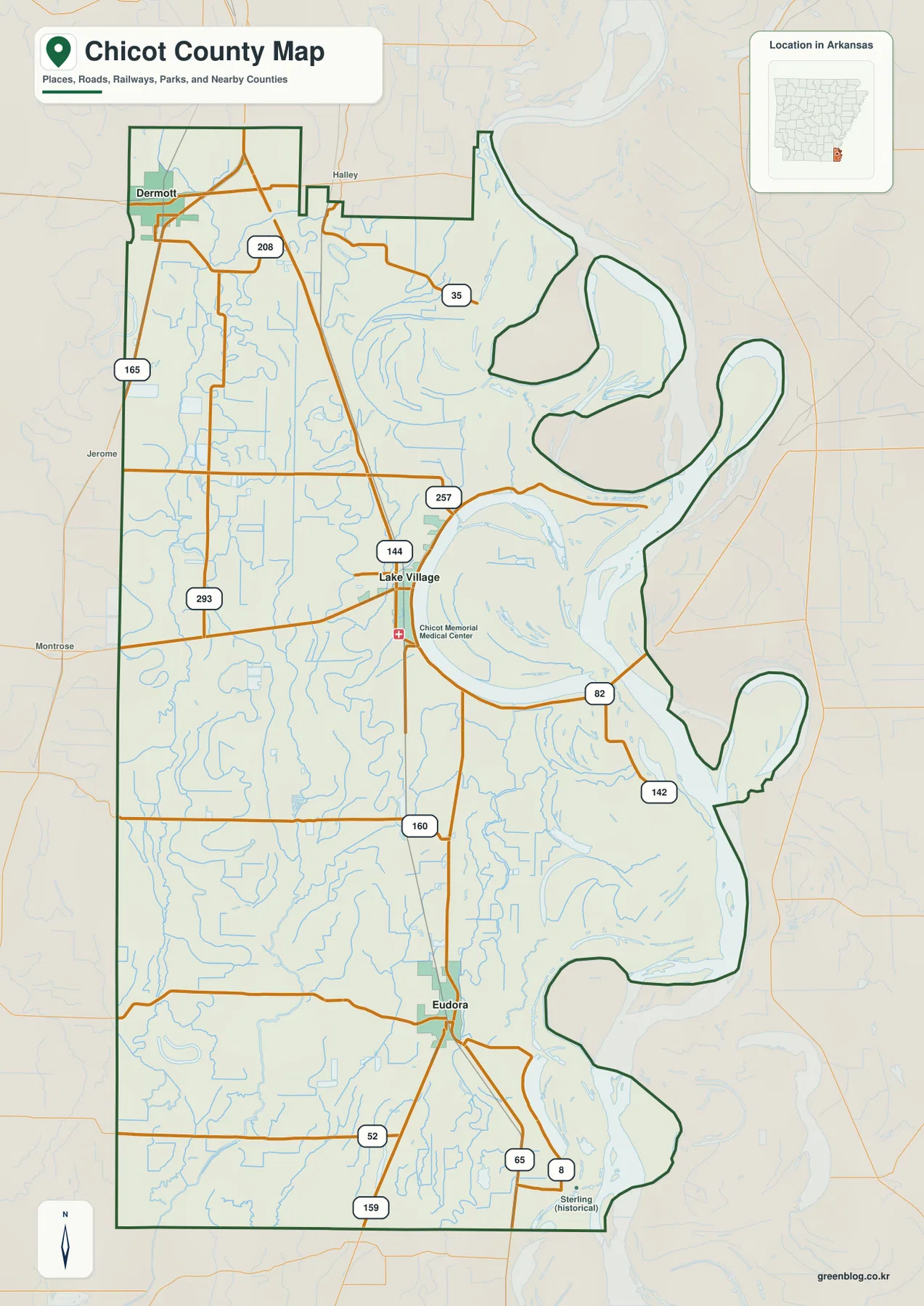
The city-connections map removes much of the road detail and makes the settlement pattern easier to remember. Dermott sits near the northwestern end of Chicot County, Lake Village lies farther south and close to the Mississippi side, and Eudora marks the southern portion. Because the three towns are separated along much of the county’s length, they provide a more useful mental frame than a single central point.
The map uses Dermott as a hub and labels Lake Village at about 16 miles and Eudora at about 30 miles. Those values are map-based connection labels rather than live driving distances, but they clarify the order of the towns. A reader can quickly see that Lake Village comes before Eudora when moving south from Dermott and that the three places are not clustered into one small urban area.
Nearby county names add another layer of orientation. Desha County appears to the north, while Ashley and Drew counties are shown to the west. Dermott is noticeably closer to the inland side, whereas Lake Village and Eudora sit much nearer the Mississippi corridor. That contrast becomes even clearer when the city map is compared with the water map.
The Mississippi River and Lake Chicot shape the eastern side
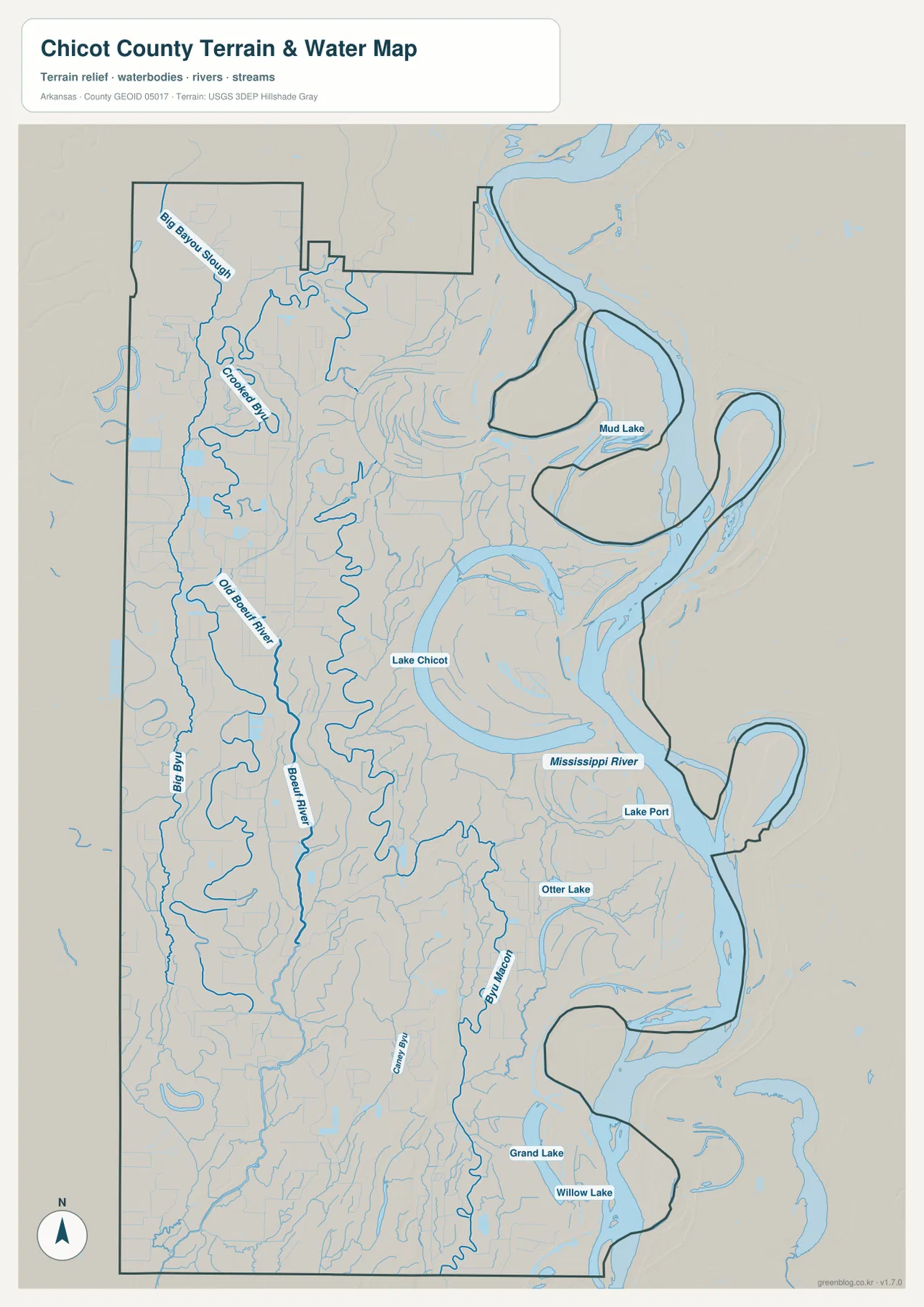
The water map is dominated by the Mississippi River along the eastern edge. Instead of running in a straight line, the river forms large loops that create a complicated county boundary. Lake Chicot is the most recognizable inland water feature beside that river. Its long curved form sits next to Lake Village, making the town easy to locate even when road labels are removed.
Arkansas tourism information describes Lake Chicot as an oxbow lake created from an older Mississippi River channel, roughly 20 miles long and the largest natural lake in Arkansas. That background matches the shape seen on the supplied water map. North of Lake Chicot, Mud Lake is labeled, while Lake Port and Otter Lake appear closer to the Mississippi. Farther south, Grand Lake and Willow Lake add more curved water bodies to the lowland landscape.
These features show why Chicot County should not be read only as a road map. Around Lake Village, the relationship between town, lake, river, and curved shoreline is a major part of the geography. The water map is appropriate for orientation and comparison, but it is not a current flood-stage map, navigation chart, or legal shoreline survey. Those uses require current agency data.
Boeuf River and the bayous fill the inland half
The Mississippi is the largest water feature, but the western half of Chicot County contains a different kind of network. Boeuf River winds south through the inland side, while Big Bayou and Crooked Bayou appear nearby. Big Bayou Slough is labeled in the northwest. These thinner channels are easy to overlook on the general county map, yet on the water map they show how frequently streams and slow-moving bayous cross the flat interior.
Bayou Macon runs through the southeastern interior and is joined by smaller channels. Together, these waterways prevent the county from being reduced to “the Mississippi and Lake Chicot.” The western and southern lowlands have their own water structure, and those channels often make more sense when viewed beside local roads and town positions.
A 26–48 meter range reveals subtle Delta relief
The elevation map uses a narrow range because Chicot County is low. Its mapped minimum is about 26 meters, the maximum about 48 meters, and the mean about 36 meters. The useful contrast is therefore not between mountains and valleys. It is between very low ground near rivers and bayous, slightly higher interior surfaces, and small ridges or natural levee-like areas that stand out only because the surrounding land is so level.
Comparing the elevation colors with the water map is especially helpful. Low colors tend to follow major river and bayou corridors, while some inland areas appear a little higher. A difference of only a few meters can be visible across this kind of landscape even though it would seem insignificant in the Ozarks. That is why the elevation file is useful for understanding the county’s low Delta setting without suggesting that it contains steep terrain.
This elevation map is intended for county-scale explanation, not engineering or parcel-level measurement. Construction, drainage design, and survey work should use authoritative elevation datasets and professional field measurements. For classroom use, regional comparison, or a general geographic overview, however, the 26–48 meter range gives a clear sense of how flat Chicot County is.
Choose the file that matches what you need to see
For a first overview, start with the general county map because it combines towns, numbered roads, the county outline, and nearby features. If you mainly need the relative positions of Dermott, Lake Village, and Eudora, the city-connections map is cleaner. The water file is the better choice for the Mississippi River, Lake Chicot, Boeuf River, Bayou Macon, and the many smaller lakes and bayous. Use the elevation file when the question is how the low terrain changes from one part of the county to another.
The downloadable JPGs are larger than the WebP previews used in the article. Each file is 2572 × 3638 pixels and follows an A3-oriented layout, making the set more practical for printing, classroom displays, reports, or close inspection of road and water labels. Keeping the four files in one ZIP also makes it easy to compare the same county from different viewpoints without saving each image separately.
Frequently Asked Questions
Which file is best for Lake Village and the main road network?
Use the general county map. It places Lake Village beside Lake Chicot and shows nearby routes such as 144, 257, and 82, plus Route 160 heading south toward Eudora. The city-connections map is simpler if you only need the relative positions of Dermott, Lake Village, and Eudora.
Why is the eastern boundary of Chicot County so curved?
The eastern side follows large bends of the Mississippi River, so the boundary loops rather than forming a straight line. Lake Chicot adds another prominent curved water feature beside Lake Village. The water map makes these shapes easier to understand than a road-only view.
What does the 26–48 meter elevation range mean?
It means the supplied county-wide elevation map shows only about 22 meters between its lowest and highest mapped values, with a mean near 36 meters. That narrow range is useful for comparing subtle lowland differences, not for detailed surveying. Engineering or construction work should rely on authoritative elevation data and professional measurements.
Sources and reference material
County-seat and local government context can be checked on the Association of Arkansas Counties Chicot County page. Background on Lake Chicot and its oxbow origin is available from Arkansas.com’s Lake Chicot guide. General boundary, road, and place data are available through U.S. Census Bureau TIGER/Line Shapefiles; hydrography through USGS National Hydrography; and elevation data through the USGS 3D Elevation Program. Place names, road labels, water features, and elevation values described in the article were taken first from the supplied Chicot County maps.
Map File Information
Chicot County Map Files
- Included Files: county map, city map, water map, elevation map
- Printable Size: 2572 × 3638 px each, A3-oriented
- File Type: JPG
Related Maps
Green Map creates custom-edited map images using open geographic data sources such as geoBoundaries, Natural Earth, OpenStreetMap, and government open data.
These maps are edited visual materials, not raw data files, and are provided for education, documents, presentations, and graphic reference.