This Sterling County Map set centers on Sterling City, the road network around U.S. 87, the North Concho River drainage, and a landscape of high ridges broken by lower creek valleys. Download the high-resolution A3 JPG map ZIP from the box below when you need files for printing or editing; the package contains separate county-reference, city, terrain-and-water, and elevation maps.
Sterling County can look simple at first because Sterling City is the only ranked major city on the supplied maps. The physical terrain is much more complicated. The North Concho River and several tributaries meet near the central part of the county, high ridges occupy large portions of the west and northwest, and another rugged band rises in the east. Lower valleys weave between those blocks of high ground, so the road and water maps make more sense when they are compared with the elevation surface.
Table of Contents
Sterling City anchors U.S. 87 and the main road directions
Sterling City is the clearest place to begin on the county reference map. U.S. 87 provides the most recognizable route through the city area, while route 158 approaches from the western county line. Route 163 forms a long north-south reference south of Sterling City, and 363 is marked near the northwest boundary. Once those four route numbers are located, the smaller road network becomes easier to follow without treating every orange line as a separate feature.
Broome appears southeast of Sterling City close to the county edge. Iolanthe is labeled farther north with a historical designation, providing a second inland reference well away from the county seat. The Sterling County Courthouse label is visible outside the eastern edge of the mapped boundary. With relatively few place names, these small labels are useful because they make the distance between the central town, the northern interior, and the southeastern edge easier to judge.
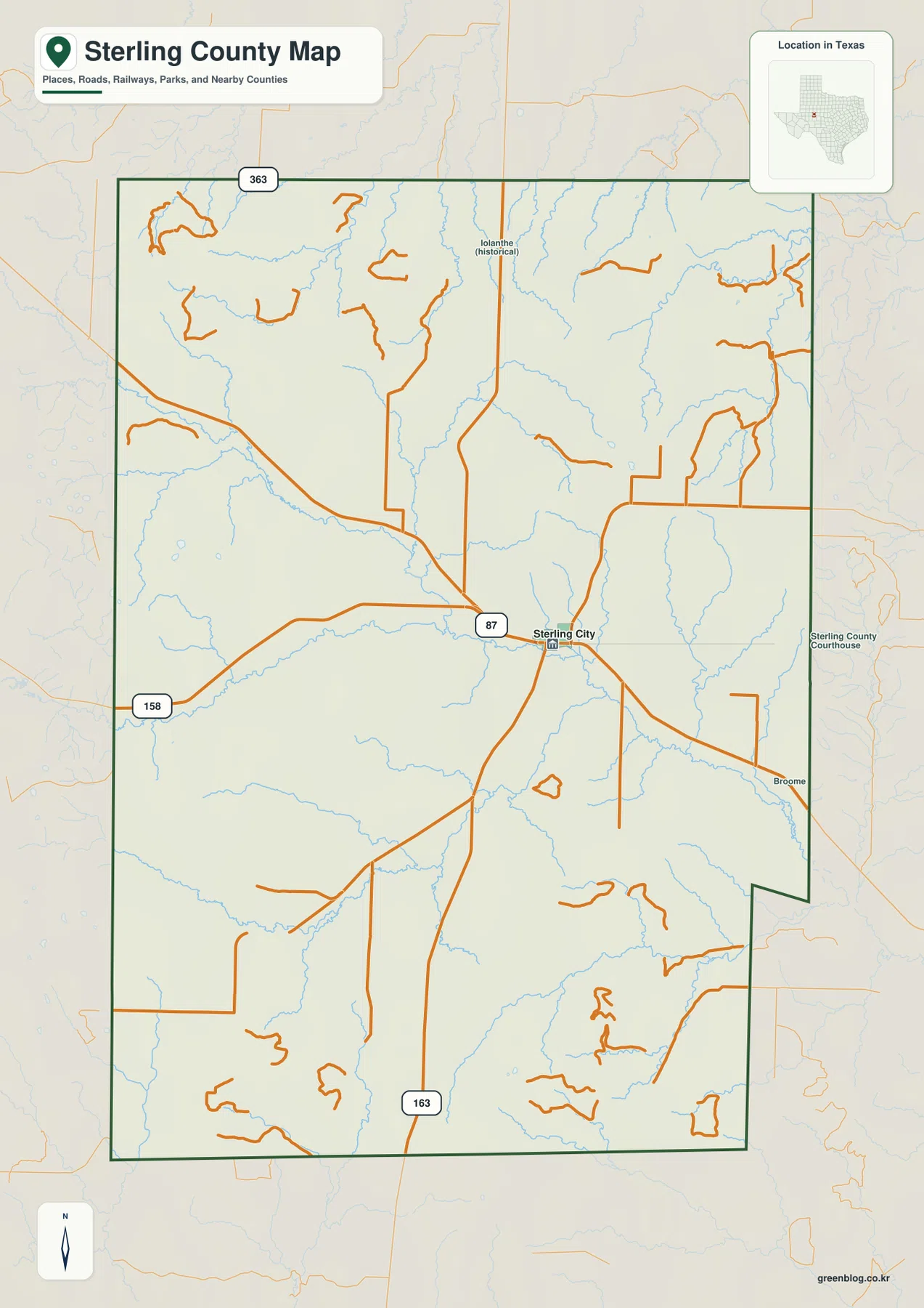
The drainage lines are nearly as visible as the roads. Thin blue streams descend from the north, larger channels meet near the Sterling City area, and a broad watercourse continues toward the southeast. Roads repeatedly cross those valleys, especially east and south of the city. The reference map is useful for travel orientation, but it also hints that the county is much more dissected than a flat open plain.
The city map reduces the county to one clear settlement reference
The ranked city map highlights only Sterling City. With secondary road labels removed, the city marker stands slightly east of the county’s center and the surrounding stream network becomes easier to see. This view is not meant to compare a group of urban centers. Its value is that Sterling City becomes an unmistakable anchor for the larger rural county.
The CITY INDEX prints Sterling City at 1,256. That number should be read as the value used by the supplied graphic rather than as a guaranteed current population estimate. Anyone needing a current demographic total should check an official statistical source. For geographic orientation, the more important fact is that Sterling City is the only major city ranked on this map.
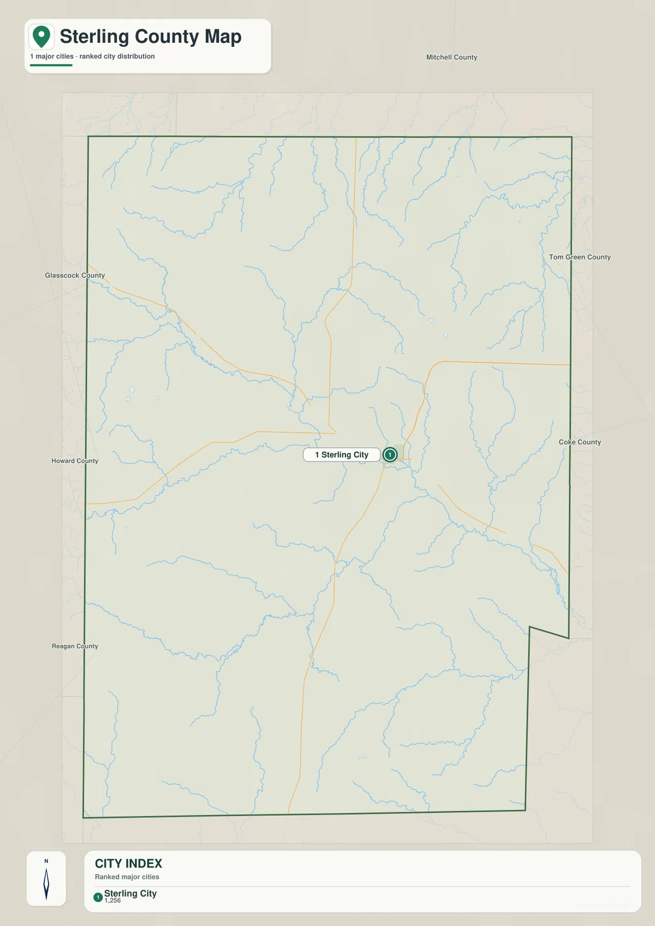
The surrounding county names add useful regional orientation. Mitchell County lies to the north, Glasscock and Howard counties are on the western side, Reagan County is southwest, and Tom Green and Coke counties appear to the east. Because Sterling City is the only strong settlement marker, these neighboring labels help place the county within west-central Texas without crowding the map.
Lacy Creek and Willow Creek feed the North Concho River corridor
The terrain-and-water map gives the strongest emphasis to the North Concho River, which crosses the central interior and continues toward the southeast. Lacy Creek approaches from the west and joins the main river near the middle of the county. Willow Creek descends from the north into the same central drainage. The meeting of those three channels is one of the most useful landmarks for understanding the county’s natural layout.
Several named tributaries divide the northern uplands. Forest Creek appears in the northwest, with Hackberry Creek and Rendelbrook Creek farther east. North Gasconades Creek and South Gasconades Creek are both labeled in the northeastern quadrant, while Dobson Creek approaches a larger channel from the west. Their narrow valleys show why the upper half of the elevation map is cut by so many fingers of lower ground.
The southern half has its own set of clear references. Sterling Creek follows a broad valley from the west toward the center. Mulberry Creek and Little Mulberry Creek occupy separate southeastern drainage lines, King Creek is labeled near the southern edge, and the Middle Concho River appears along the southwest side. Unlike a county dominated by large lakes, Sterling County’s water map is defined mainly by long creeks and river corridors.
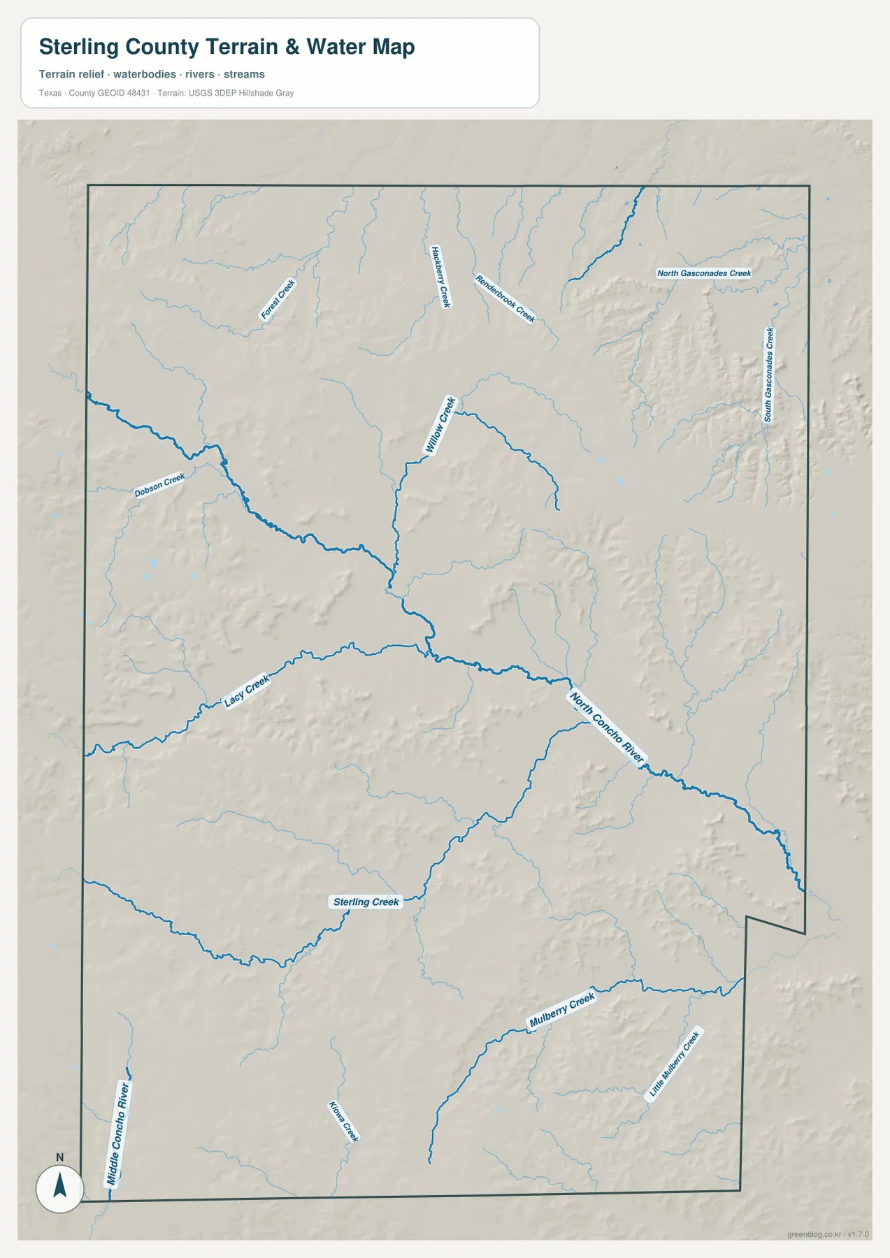
This layer is intended for geographic water reference rather than flood-risk analysis, parcel boundaries, navigation, or water-management decisions. It is most useful for seeing where the named channels meet, how tributaries descend from the higher terrain, and why the central river corridor is lower than many of the ridges around it.
High western blocks are separated by a lower central river valley
The elevation map reports an actual range of about 609 to 841 meters and a mean elevation of 756 meters. The darkest brown high ground is especially strong in the northwest and along parts of the western edge. Broad high terrain also occupies much of the southwest, while a separate rugged belt rises in the east-central part of the county. Green terrain is more widespread along the central drainage and toward portions of the eastern edge.
The pattern is not a simple west-to-east slope. High ridges are divided by narrow lower valleys, and the central interior contains a long green corridor that matches the North Concho River and connected tributaries on the water map. Farther south, similar low fingers cut into the uplands, while the northeast includes both elevated ridges and lower drainage areas. Comparing the two maps is therefore more informative than relying only on the maximum and minimum elevation numbers.
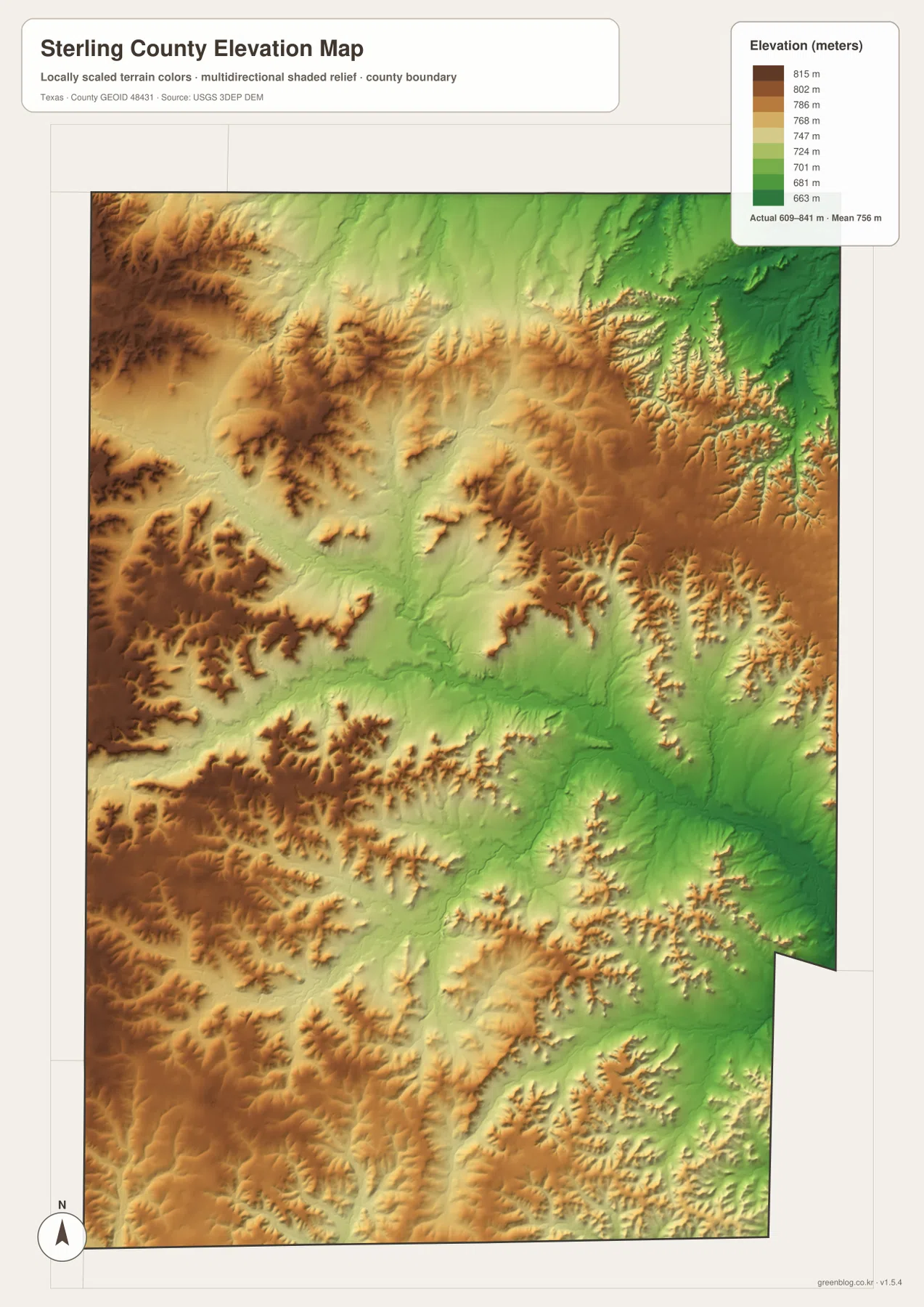
This countywide elevation surface is intended for broad terrain comparison, not parcel surveying or engineering design. It is useful for seeing where the strongest ridges are concentrated, where creek valleys cut through them, and how the land around Sterling City relates to the larger North Concho drainage. Exact elevation for a property or structure should be checked with detailed source data or a local survey.
Choose the view based on roads, river corridors, or relief
Use the county reference map when Sterling City, U.S. 87, route 158, route 163, Broome, and the county boundary need to appear together. The city map is cleaner when Sterling City alone should stand out. The terrain-and-water layer is the best place to trace the North Concho River, Lacy Creek, Willow Creek, and the southern tributaries, while the elevation map makes the high western ridges and lower central valleys easiest to compare.
The downloadable ZIP contains four separate high-resolution A3 JPG files for Sterling County: county reference, ranked city, terrain and water, and elevation. You can inspect the WebP versions in the article first and then use the larger JPG files for printing, classroom material, presentations, or an editable local-reference document.
Frequently Asked Questions
Where is Broome in relation to Sterling City?
Broome is southeast of Sterling City near the county edge on the supplied reference map. Following the U.S. 87 direction toward the southeast makes it easy to locate.
Where does the North Concho River run through Sterling County?
The water map shows the North Concho River crossing the central part of the county and continuing southeast. Lacy Creek joins from the west and Willow Creek approaches from the north near the central drainage area.
What elevation range is shown for Sterling County?
The supplied elevation map states an actual range of about 609 to 841 meters and a mean of 756 meters. High terrain is prominent in the northwest and southwest, while lower corridors follow the central river system and parts of the east.
Map File Information
The ZIP contains the four Sterling County maps in high-resolution A3 JPG format.
- Included Versions: County reference, ranked city, terrain and water, elevation
- Included Files: 4 A3 JPG maps
Related Maps
Sources and data references
Roads and county boundaries around Sterling City can be cross-checked with the U.S. Census Bureau TIGER/Line Shapefiles. The North Concho River and named creeks can be checked against USGS National Hydrography, while terrain height data are available through the USGS 3D Elevation Program. Route labels, place names, water features, and the 609–841 meter elevation range described above are based on the Sterling County maps supplied in this package.
Green Map creates custom-edited map images using open geographic data sources such as geoBoundaries, Natural Earth, OpenStreetMap, and government open data.
These maps are edited visual materials, not raw data files, and are provided for education, documents, presentations, and graphic reference.