You can download the Madison County Tennessee Map files on this page as an A3 high-resolution JPG set. The maps cover the county boundary and road network, the relative positions of Jackson, Three Way, and Medon, the Forked Deer River system, and the county’s elevation. Using the maps together is especially helpful here because Madison County has a strong urban center in Jackson but a much more varied pattern of streams, lowlands, ridges, and smaller communities beyond the city.
Jackson occupies the middle of the county and immediately stands out as the largest built area. Three Way sits near the northern edge, while Medon lies close to the southern boundary. Beech Bluff and Pinson provide useful eastern and southeastern reference points on the general county map. Between these places, the water map shows three named branches of the Forked Deer River, and the elevation map reveals why so many smaller streams wind through the county: low valleys are separated by repeated belts of higher rolling ground.
Table of Contents
Jackson is the road hub, but the county extends well beyond the city
The general map makes Jackson the easiest place to begin. US 45 runs north and south through the central part of the county, while I-40, US 70, and US 412 provide major east-west connections. Several state routes branch away from this central network. The result is not a simple grid: roads converge around Jackson and then spread toward different county edges, matching the positions of smaller communities and the shape of the local terrain.
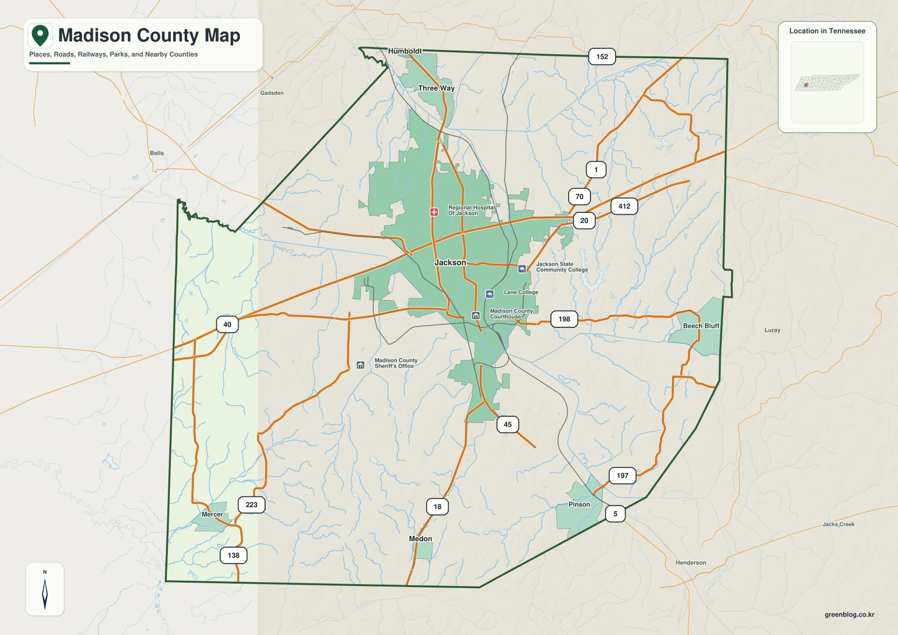
North of Jackson, Three Way sits along the US 45 direction near the top of the county. Medon is almost the opposite reference point, close to the southern edge along the SR 18 corridor. On the eastern side, Beech Bluff and Pinson help show how settlement continues away from the Jackson core. These labels are useful not because they are equal in size, but because they make the county’s internal directions easy to understand without filling the map with every local road and place name.
Madison County also shares boundaries with Gibson and Carroll counties to the north, Chester and Henderson counties to the east, Hardeman County to the south, and Haywood and Crockett counties to the west. The highway and stream lines continue across those boundaries, so an edge location should be read in relation to the neighboring county rather than as an isolated point inside Madison County.
Three Way and Medon make the north-south layout easy to see
The city-connection map intentionally reduces the number of labels and emphasizes Jackson, Three Way, and Medon. Jackson is shown as the hub, Three Way as the northern connection, and Medon as the southern connection. That simplified view is useful when the general county map feels busy because it shows a long north-south relationship before the smaller roads, streams, and eastern communities are added back in.
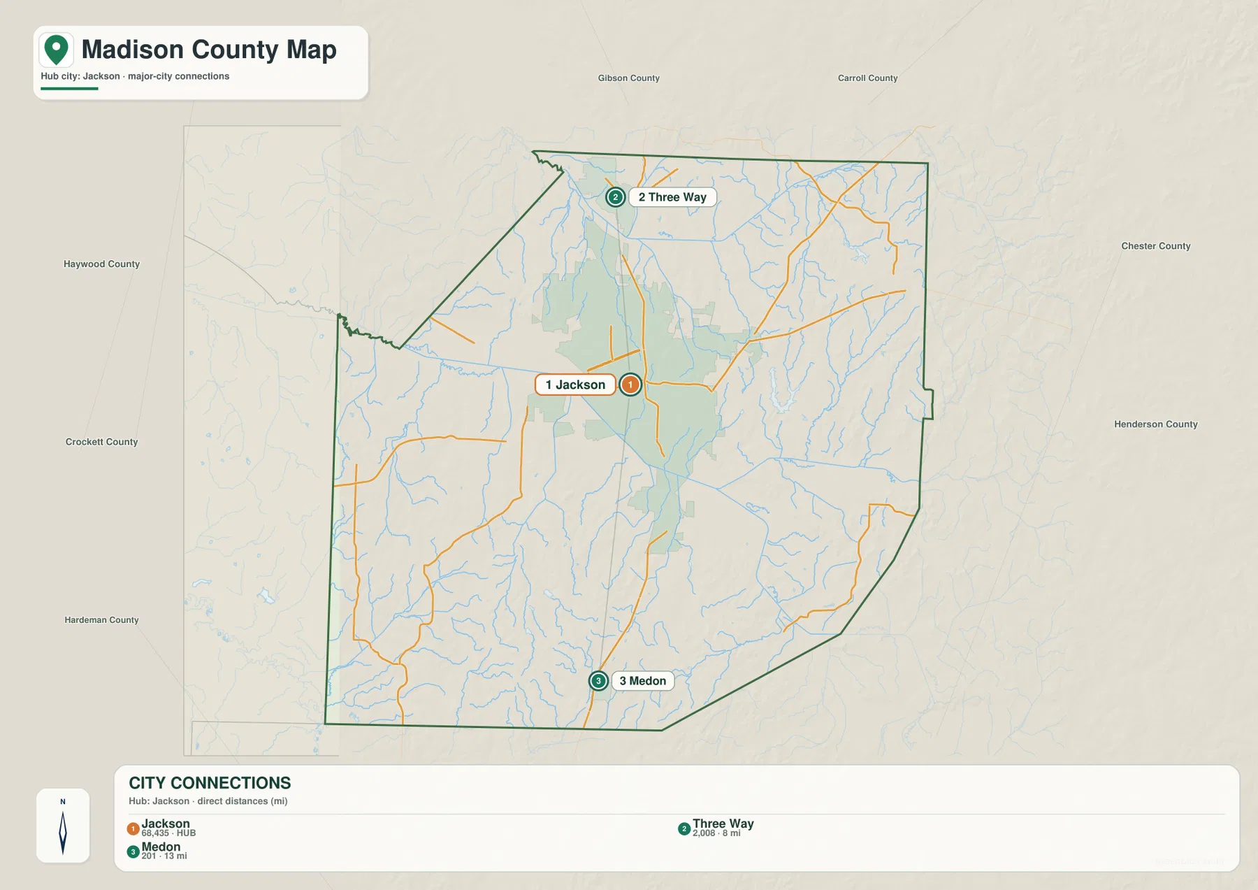
This view also highlights how much of Madison County remains outside the dense Jackson footprint. The built area around Jackson is broad, but most of the county is shown as open space crossed by roads and streams rather than continuous urban development. For a classroom map, a planning sketch, or a location graphic, marking these three places first gives enough structure to add other features without losing the county’s overall shape.
Three Forked Deer branches divide the county into distinct drainage areas
The terrain-and-water map is one of the most distinctive parts of this Madison County set. The Middle Fork Forked Deer River crosses the northern part of the county. The South Fork Forked Deer River forms a long central watercourse, while the North Fork Forked Deer River is labeled farther east. Seeing the three names on the same map makes it clear that “Forked Deer River” in Madison County is not just one line passing through one valley.
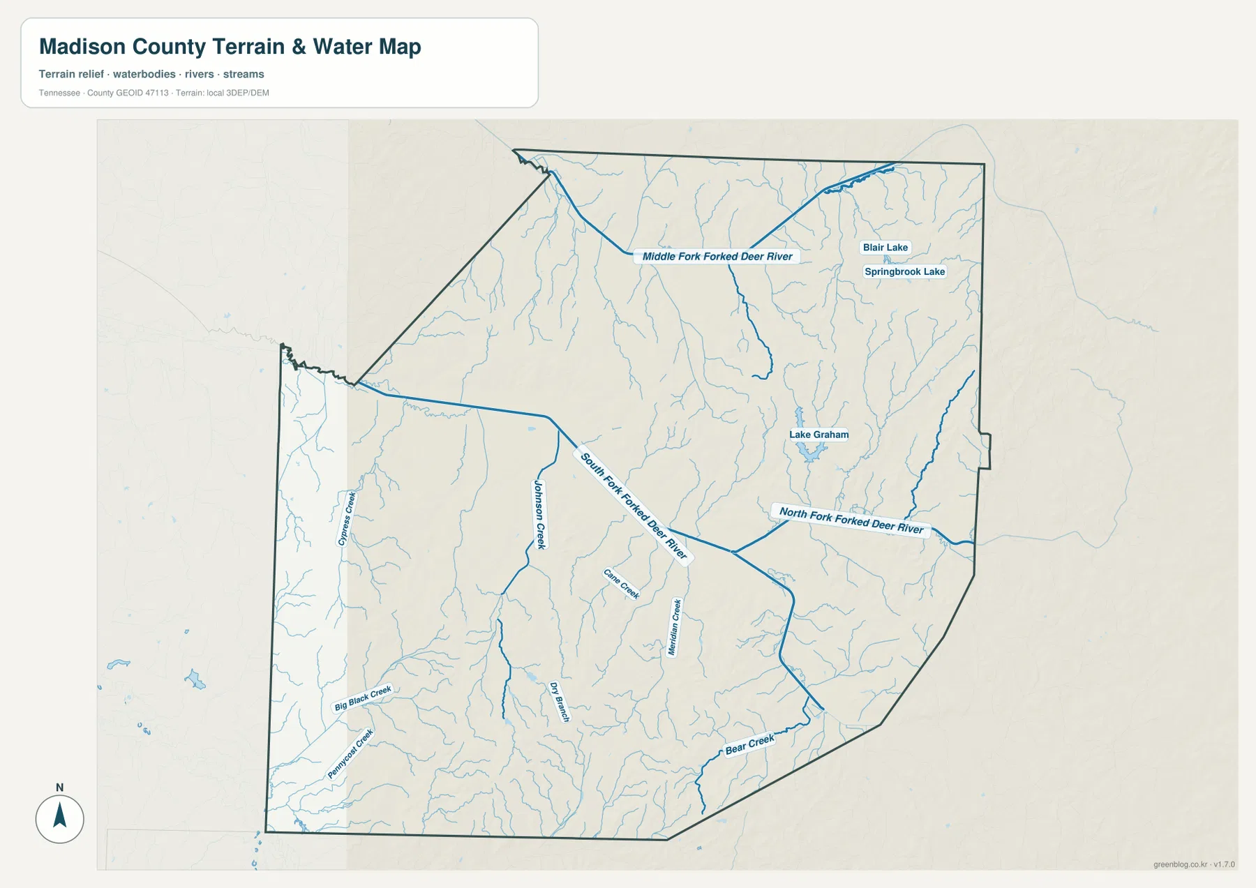
Lake Graham is a prominent named lake in the eastern half of the county. Blair Lake and Springbrook Lake appear farther northeast. The map also labels smaller streams such as Johnson Creek, Cane Creek, Meridian Creek, Bear Creek, Big Black Creek, and Cypress Creek. These smaller channels fill in the spaces between the major river branches and show how extensively the county is dissected by drainage lines.
The water layer is particularly useful around Jackson because a road-only view can make the central part of the county appear flatter and simpler than it really is. Streams occupy the low corridors between rolling ridges, and roads either cross those corridors or follow gentler ground alongside them. This is a county reference map rather than a navigation product, but the water network helps explain why road lines bend, why some areas have fewer direct connections, and why places that look close in a straight line may sit on opposite sides of a drainage corridor.
Low stream valleys cut through higher ground in the northeast and south
The elevation map gives an actual range of about 93 to 202 meters, with a mean elevation of about 133 meters. The broad green zones are the lower parts of the landscape. One of the most noticeable low corridors passes through the central portion of the county and connects with the river network seen on the water map. Higher tan and brown areas are more common in the northeast and across parts of the south.
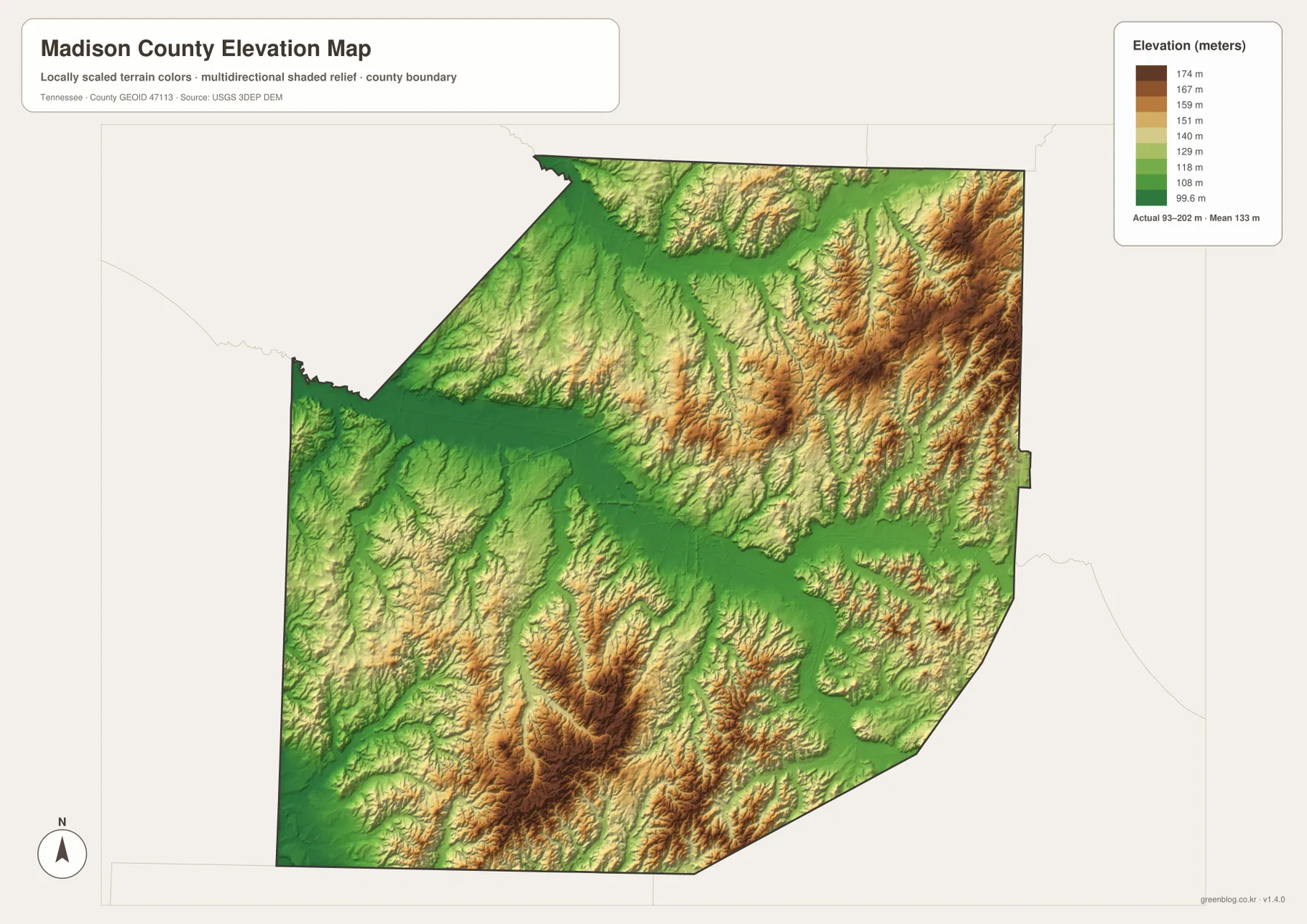
The northeast is especially textured, with many short ridges and narrow valleys. Southern Madison County also contains repeated high and low bands rather than one broad flat surface. In contrast, the greener central and western corridors are wider and lower. When the elevation and water maps are compared side by side, many named streams occupy those lower zones while tributaries descend from the higher ground around them.
This relief is modest compared with mountain counties in eastern Tennessee, but it is still important at the scale of local roads and drainage. A difference of roughly one hundred meters across a county is enough to produce many small valleys, ridge tops, and changes in slope. The shaded-relief image makes those details visible without requiring contour-line reading.
What each map adds to a Madison County reference
The general county map is best when you need Jackson, surrounding communities, highways, and the boundary in one view. The city map is cleaner when the main question is how Jackson relates to Three Way and Medon. The water map is the strongest choice for the Forked Deer system, Lake Graham, and smaller creeks, while the elevation map explains the pattern of low valleys and higher rolling ground. Choosing the map that matches the question keeps the page practical instead of forcing every detail onto one image.
The Census references included with the package add scale without replacing the geography shown here. Madison County recorded 98,823 residents in the 2020 census, and the July 2025 estimate is 100,790. Gazetteer data list about 557.2 square miles of land and 1.5 square miles of water. Those totals describe the county as a whole; the maps are what show the contrast between the large Jackson urban area, smaller edge communities, broad low stream corridors, and hillier sections of the county.
For print work, one map can serve as the main page while another acts as a supporting graphic. A road-oriented handout can pair the county map with the water map to show where major crossings occur. A physical-geography lesson can place the water and elevation maps together so students can compare river branches with low terrain. The downloadable files are high-resolution JPGs sized for A3 output, which also leaves room for annotations when the map is used in a report or classroom activity.
Frequently Asked Questions
How can I quickly locate Jackson, Three Way, and Medon?
Start with Jackson near the center of Madison County. Three Way is near the northern boundary along the US 45 direction, while Medon is near the southern edge along the SR 18 direction. Those three labels provide an easy north-south frame before you add Beech Bluff, Pinson, and the smaller roads.
Does the map show more than one Forked Deer River branch?
Yes. The water map separately labels the Middle Fork, North Fork, and South Fork Forked Deer River. Lake Graham and numerous smaller creeks are also shown, so the map is useful for seeing how several drainage areas fit together inside one county.
What does the elevation map reveal about Madison County?
It shows an actual range of about 93 to 202 meters. Lower green corridors line up with major stream valleys, including the broad central drainage areas, while higher rolling ground is more prominent in the northeast and parts of the south. Comparing the elevation map with the water map makes that relationship especially clear.
Map File Information
The ZIP contains four A3 high-resolution JPG files for Madison County: the general county map, city map, water map, and elevation map shown on this page.
- Included Files: county map, city map, water map, elevation map
- File Type: JPG
Related Maps
- Alamo to Gadsden: A Crockett County Tennessee Map
- Altamont, Monteagle, and Plateau Valleys — Grundy County Tennessee Map
- Around Chattanooga: Hamilton County Tennessee Map
Sources and References
- Tennessee State Library and Archives — Madison County fact sheet
- Tennessee Department of Transportation — Madison County road reference
- U.S. Census Bureau — Madison County QuickFacts
- U.S. Census Bureau — TIGER/Line boundary data
- USGS — National Hydrography
- USGS — 3D Elevation Program
Green Map creates custom-edited map images using open geographic data sources such as geoBoundaries, Natural Earth, OpenStreetMap, and government open data. These maps are edited visual materials, not raw data files, and are provided for education, documents, presentations, and graphic reference.