You can download this Macon County Tennessee Map as an A3-layout ZIP of high-resolution JPG files. Before the download, the maps help place Lafayette near the county’s center, Red Boiling Springs in the east, State Route 52 across the county, and the many creek valleys that cut through the rolling ground along Tennessee’s Kentucky border.
Macon County is defined here by a network of small valleys rather than by one dominant river or reservoir. Long Creek and its western branches, White Oak Creek and Long Fork through the middle and east, and Salt Lick Creek farther northeast form repeated low corridors between higher ridges. Lafayette sits where several roads meet, while Red Boiling Springs gives the eastern side a second clear reference point. The road, water, and elevation sheets expose different parts of that same Lafayette-to-creek-valley pattern.
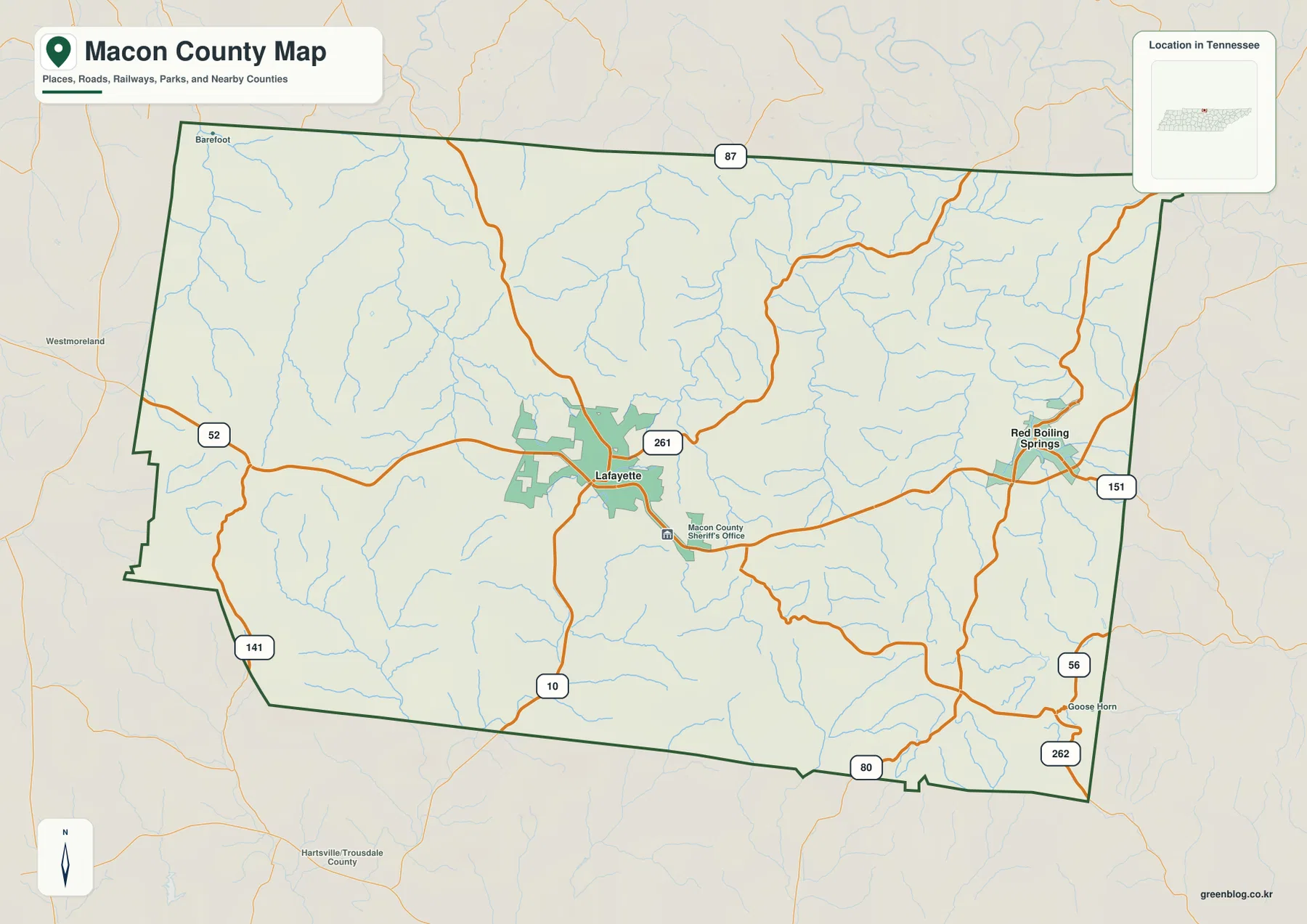
Table of Contents
Lafayette and Red Boiling Springs set the county’s east–west scale
Lafayette is the first place to locate because it is the county seat and because several mapped routes meet around its built-up area. From Lafayette, the western county line, the Kentucky border to the north, the southern edge toward Smith County, and the eastern road toward Red Boiling Springs can all be judged from one central reference. The general map gives Lafayette enough surrounding road and stream detail to make those directions clear without treating the city as the whole county.
Red Boiling Springs lies well to the east of Lafayette and changes the way the county should be read. It provides a second named center near the eastern road network, close to routes that continue toward Clay and Jackson counties. Once both cities are marked, Macon County no longer looks like a blank rural polygon: the space between them becomes a corridor crossed by roads, small branches, and ridge-and-valley terrain.
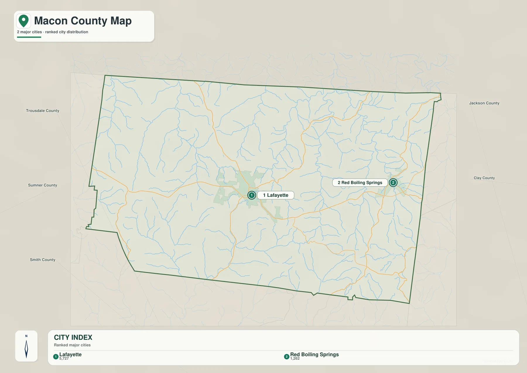
The city sheet deliberately removes much of the smaller geographic detail. The stripped-down view puts the distance between Lafayette and Red Boiling Springs ahead of smaller roads and stream labels. Establish those two place references first, then return to the detailed county sheet to trace a specific route without losing the county’s east–west scale.
SR 52 crosses the county while other state routes branch toward the borders
State Route 52 supplies the clearest east–west road reference on the map. It passes through the Lafayette area and continues toward Red Boiling Springs, directly linking the county’s central and eastern settlement references. Follow SR 52 first, then place the smaller branches around it: SR 87 appears near the northern side, SR 261 leaves the Lafayette area toward the northeast, and SR 151 and SR 56 help organize the eastern routes around Red Boiling Springs.
South of Lafayette, the map adds Route 10, while SR 141 approaches the southwest and SR 80 and SR 262 appear closer to the southern and southeastern edges. These roads matter because Macon County is bordered by several Tennessee counties as well as Kentucky. A route that looks local inside the county may soon cross into Sumner, Trousdale, Smith, Jackson, or Clay County, so the dark county outline is as important as the road number when following a trip across the map.
The road curves also make more sense when compared with the physical maps. Macon County is not a flat grid. Ridge tops and narrow drainage valleys interrupt straight-line travel, and roads often approach lower ground, cross a creek, or turn around higher terrain. SR 52 remains the best broad reference, but the water and elevation sheets explain many of the bends that are easy to overlook on a road-only view.
Long Creek in the west and Salt Lick Creek in the east reveal the valley pattern
The terrain-and-water map is crowded with named creeks, and that density is one of Macon County’s defining features. West Fork Long Creek and Long Creek stand out on the western side, with Trammel Creek and Stratton Branch adding smaller channels nearby. Cat Creek and Middle Fork occupy the southwest, while Dry Fork extends through the south-central part of the county. The map therefore shows a landscape divided by many modest drainages rather than one broad water body.
Moving eastward, White Oak Creek and Long Fork become useful landmarks in the central and eastern interior. Salt Lick Creek bends through the northeast, and Long Hungry Creek is prominent in the southeast. Little Puncheon Creek and Puncheon Creek add more branches in the northern interior. These names matter because each channel marks a low corridor between surrounding ridges, helping explain why nearby roads and communities may be separated by more terrain than the county outline alone suggests.
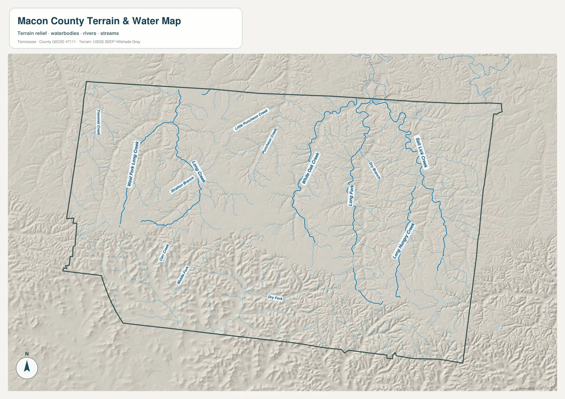
This sheet explains drainage and terrain relationships; it is not current flood, navigation, or engineering information. Mark Lafayette and Red Boiling Springs, identify the nearest named creek, and then check the same location on the road and elevation sheets. That sequence links a place name to a valley and then to the higher ground around it without turning the map into a list of unrelated stream names.
The 154–334 m elevation range is expressed as repeated ridges and narrow low corridors
The elevation legend gives Macon County a range of roughly 154 to 334 meters, with a mean near 263 meters. The important feature is not simply the 180-meter difference between the lowest and highest mapped values. Green lower ground appears in narrow corridors, while tan and brown higher areas repeat on the ridges between them. The county therefore looks textured from west to east instead of rising steadily in a single direction.
Some of the broader low colors appear in the southwest, but narrow lower strips also follow drainage lines through the central and eastern parts of the county. Around Salt Lick Creek and Long Hungry Creek, the relationship is especially easy to compare because the water sheet identifies the channels and the elevation sheet places those channels within lower-colored terrain. Similar pairings occur around Long Creek and other western drainages.
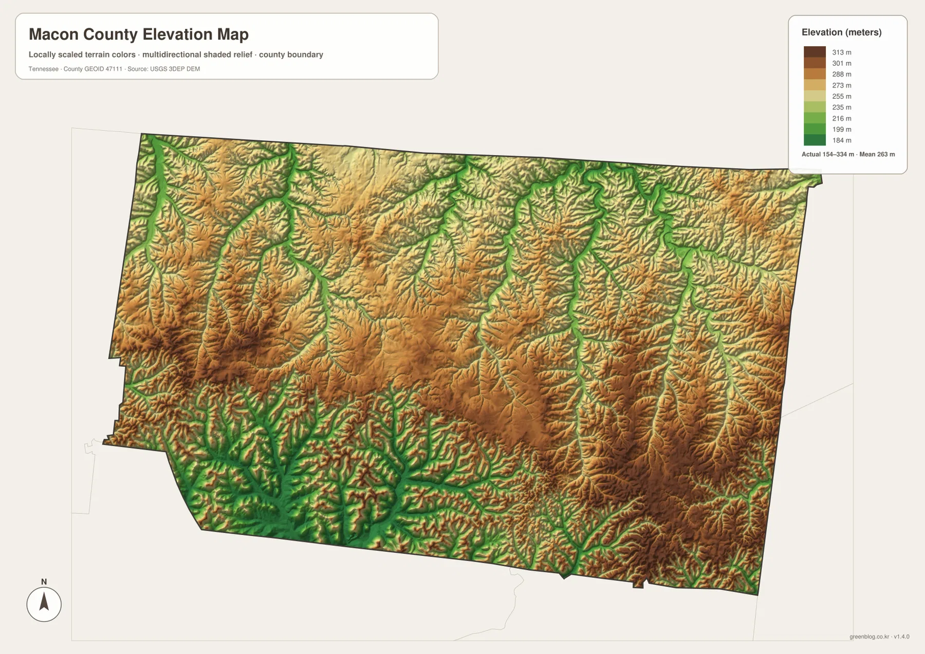
That relief is enough to affect how roads and streams fit together even though Macon County is not mountainous in the sense of East Tennessee’s highest terrain. A road may descend toward a creek, bend along a valley, and climb again toward a ridge. When two points look close in straight-line distance, the elevation sheet can show why the actual road between them follows a less direct course.
The Tennessee–Kentucky line forms the entire northern frame
Macon County’s northern boundary is also the state line. The county materials place Monroe and Allen counties on the Kentucky side, while Clay, Jackson, Smith, Trousdale, and Sumner counties surround the Tennessee sides. This matters whenever a road, address, stream, or service area crosses the northern edge because the crossing is not merely from one county to another; it also enters a different state jurisdiction.
The eastern side is easiest to judge from Red Boiling Springs, where routes approach the Clay County boundary. West of Lafayette, the county map provides the frame for connections toward Sumner and Trousdale counties. Along the south, Smith County helps orient the road and creek exits. The water sheet is a reminder that a drainage does not stop at the political line, even when the county map correctly clips the display to Macon County.
The Tennessee State Library and Archives material in the package notes that Macon County was established in 1842 and identifies Lafayette as the county seat. That historical background explains the jurisdiction name, while the maps here describe the present geographic arrangement. Historic property research or older community boundaries should be checked against records from the relevant period rather than assumed to match the modern county outline.
Population and area figures add scale without replacing the map
The Census material included with the package records 25,216 residents in the 2020 decennial census and a July 2025 estimate of 27,663. The estimate is about 9.7 percent above the 2020 count. Those figures describe the county as a whole, but they do not identify where growth occurred. Lafayette, Red Boiling Springs, rural road corridors, creek valleys, and ridge-top areas can have very different settlement patterns even when they contribute to the same county total.
The 2025 Gazetteer values supplied in the package list roughly 307.1 square miles of land and about 0.1 square mile of water. The tiny water-area number can be misleading if it is read without the terrain sheet. Macon County has many narrow creeks, but those channels cover little surface area compared with a reservoir or broad lake. The water map therefore looks much busier than the countywide water-area statistic might suggest.
Dividing the 2020 population by the listed land area gives an average of about 82 residents per square mile. That number is a countywide average, not a picture of uniform settlement. The city sheet shows why: Lafayette forms the strongest built reference, Red Boiling Springs marks another concentrated place farther east, and much of the remaining county is organized along rural roads and narrow valleys. The statistic becomes more meaningful after those differences are visible.
Choose the sheet by the Macon County feature you need to trace
Open the county sheet first when the task involves a route between Lafayette, Red Boiling Springs, and a county boundary. It keeps the cities, principal roads, streams, and boundary in one frame, so the point where SR 52 or another state route leaves Macon County remains visible. If the task is only to compare the two main city references with neighboring counties, the simpler city sheet removes many of the lines that are not needed.
Choose the terrain-and-water sheet for Long Creek, White Oak Creek, Long Fork, Salt Lick Creek, Long Hungry Creek, or smaller tributaries. Choose the elevation sheet when the question shifts from the stream itself to the ridges around it. Side-by-side, the blue drainage lines align with lower elevation corridors while the ridges occupy the higher ground between them.
The downloadable JPG set keeps those subjects separate for annotation. You can mark an SR 52 route on one county copy, circle Lafayette and Red Boiling Springs on the city copy, label a particular creek branch on the terrain sheet, and note a ridge or low corridor on the elevation sheet. The result is a set of Macon County references that can be annotated without covering one image with every kind of information at once.
Frequently Asked Questions
Why should I locate Lafayette and Red Boiling Springs before tracing smaller roads?
Lafayette gives you the county seat and the main central road reference, while Red Boiling Springs anchors the eastern side. Once both are located, SR 52 and the other state routes can be followed without losing the county’s east–west scale.
Why does Macon County’s water map look dense even though the county has very little water area?
The county contains many narrow streams rather than a large lake. Long Creek, White Oak Creek, Long Fork, Salt Lick Creek, Long Hungry Creek, and smaller branches occupy little surface area but create a closely spaced network of drainage valleys across the map.
What is included in the Macon County map download?
The ZIP contains four high-resolution JPG files: a general county map, a simplified city map, a terrain-and-water map, and an elevation map. They use an A3 layout and correspond to the WebP previews shown in the article.
Map File Information
Download the Macon County Map Files
- Included Files: county, city, terrain-and-water, and elevation maps
Related Maps
- Putnam County Tennessee map | Cookeville and Highland Rim
- Alamo to Gadsden: A Crockett County Tennessee Map
- Altamont, Monteagle, and Plateau Valleys — Grundy County Tennessee Map
Sources and References
- Tennessee State Library and Archives — Macon County fact sheet for county history and county-seat reference
- Tennessee Department of Transportation — Macon County functional class map for road reference
- U.S. Census Bureau TIGER/Line for geographic boundaries
- U.S. Census Bureau QuickFacts for population data
- U.S. Census Bureau Gazetteer Files for land and water area
- USGS National Hydrography and USGS 3D Elevation Program for stream and elevation reference
Green Map creates custom-edited map images using open geographic data sources such as geoBoundaries, Natural Earth, OpenStreetMap, and government open data. These maps are edited visual materials, not raw data files, and are provided for education, documents, presentations, and graphic reference.