Gallatin County sits in southeastern Illinois where Route 13, the Saline River system, the Ohio River edge, and higher southern ridges create a varied landscape. You can download the original high-resolution JPG map files in one ZIP directly from this page, while the browser images serve as quick previews. Shawneetown and Old Shawneetown lie near the Ohio River side of the county, Equality and Junction provide useful references farther west, Ridgway anchors the north-central interior, and Omaha and New Haven mark different parts of the northern edge. The article uses the county, city, water, and elevation maps to explain how those places, roads, waterways, and relief fit together.
Route 13 is one of the easiest lines to follow on the general map. It runs from the Equality side across Junction toward Shawneetown, linking the western interior with the Ohio River side. Route 1 provides a strong north-south reference through the county, passing near Omaha and Ridgway before continuing south. New Haven sits near the northeastern projection of the county where Routes 141 and 200 are labeled. Seen together, these roads help explain why Gallatin County has a relatively straight western side but a much more irregular eastern boundary that follows the river-side landscape.
The water and elevation maps add another layer of detail. The Saline River and North Fork Saline River cross lower valleys in the west and center, while the broad Ohio River occupies the east and southeast. The elevation legend reports an actual mapped range of about 100 to 280 meters and a mean of 118 meters. Much of the eastern county remains low, but higher ground rises sharply in the southwest and appears again in several southern and east-central ridges. The downloadable map package is useful when those small creek names, road numbers, and relief details need to be enlarged beyond the browser preview.
Table of Contents
Route 13 links Equality and Junction with Shawneetown on the Ohio River side
The general county map works especially well for understanding east-west position. Starting near the western boundary, Equality appears close to Route 142 and the Route 13 corridor. Moving east, Junction sits near the middle of that corridor, followed by Shawneetown near the river side and Old Shawneetown farther southeast. This sequence provides a simple geographic reference across the lower half of the county without requiring every local road to be shown. It also makes the contrast between the straighter western boundary and the curved Ohio River side much easier to recognize.
Route 1 supplies the main north-south reference. It descends from the Omaha area, passes the Ridgway part of the county, and continues south through the interior. Route 250 is labeled near Omaha, while New Haven is associated with Routes 141 and 200 in the northeastern projection. Route 45 appears near the northwest edge. These highways and state routes are useful for orientation, but the map is not a turn-by-turn navigation product and does not show temporary closures, every local road, traffic conditions, or current construction.
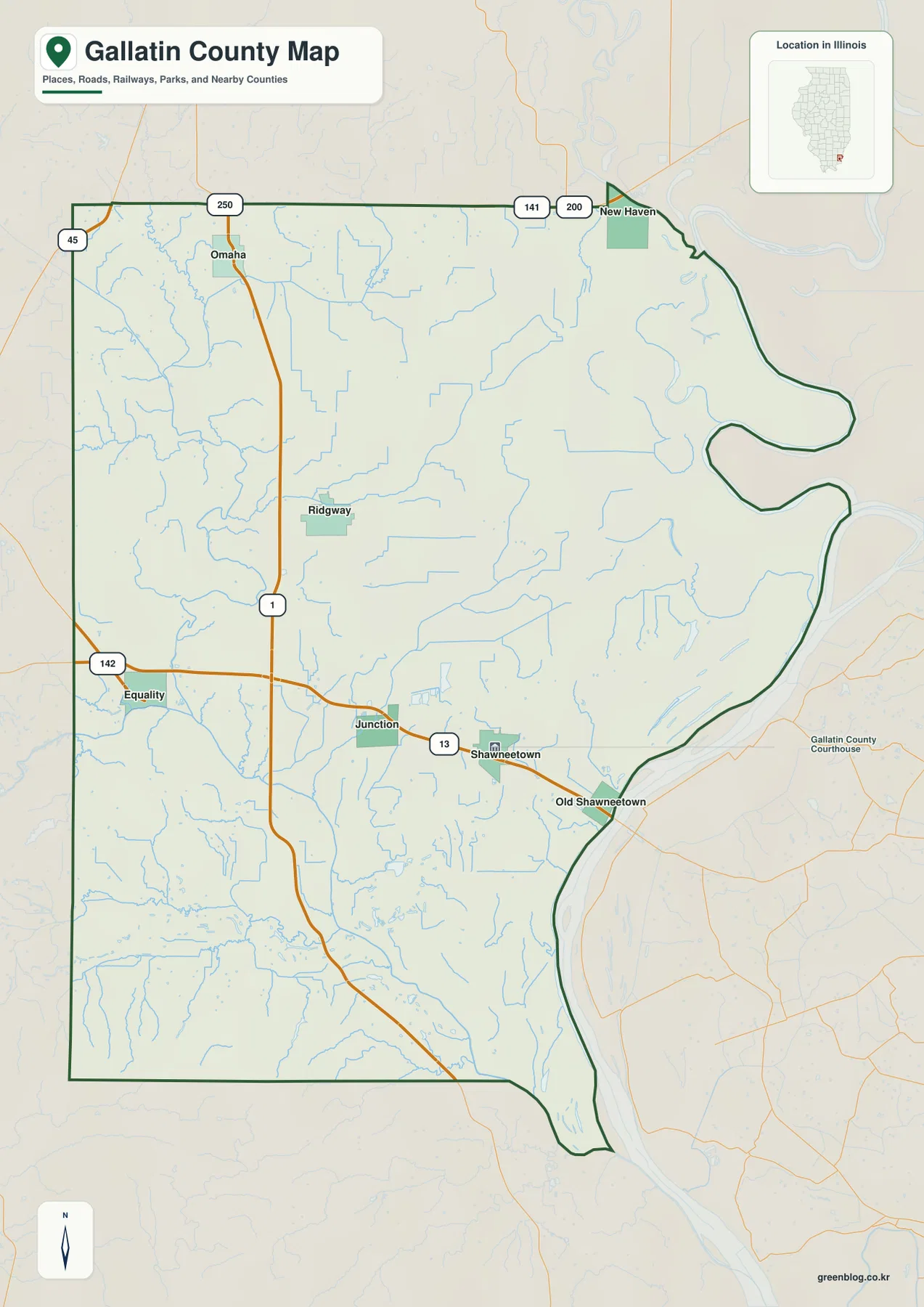
The county outline itself is a useful part of the map. Gallatin County extends eastward along several large bends, and New Haven sits close to a narrow northeastern extension. The lower eastern boundary then follows the Ohio River side toward the pointed southern end. A courthouse label is also shown outside the main county outline near Shawneetown, reinforcing Shawneetown as an important reference when locating county services. The official Gallatin County website likewise lists county offices in Shawneetown, so the place name serves both as a map anchor and as a practical administrative reference.
The six-city index spreads from Shawneetown and Ridgway to the northern edge
The ranked city map strips away much of the road detail and emphasizes six labeled places. Shawneetown is listed first at 1,087, followed by Ridgway at 779 and Equality at 609. New Haven is fourth at 464, Omaha fifth at 171, and Old Shawneetown sixth at 102. These figures are best treated as the values supplied with this particular city index rather than as a claim about the latest official population estimates. Their main value here is to show the relative ranking and geographic spread of the mapped communities.
The distribution is not concentrated in one compact urban cluster. Shawneetown and Old Shawneetown sit close together in the southeast, but Ridgway lies well to the north in the interior. Equality is near the western edge, Omaha occupies the northwestern part of the county, and New Haven is separated to the northeast. Because the six points occupy several different parts of the county, the city map makes the irregular outline more apparent than a simple list of names would. It also shows how river-side places and inland places are distributed across a relatively small county.
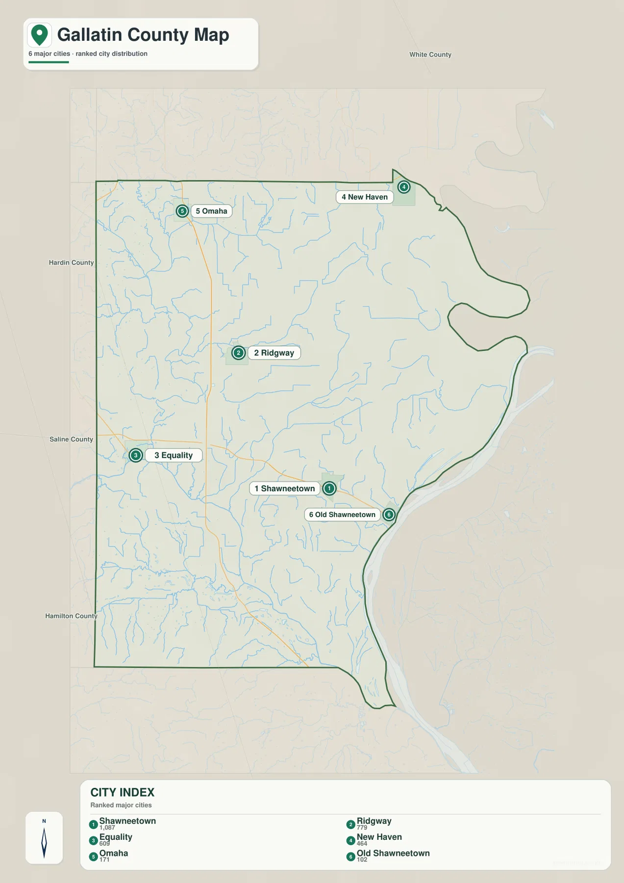
Pairing the city map with the road map adds useful context. Shawneetown is associated with the Route 13 corridor near the Ohio River, Ridgway sits close to Route 1 in the north-central interior, and Equality lies near the western approach from Route 142. Omaha is close to the Route 250 and Route 1 area, while New Haven sits near the 141 and 200 labels. If the goal is only to compare place positions, the city map is cleaner; if road numbers matter, the general map provides the missing context.
Saline River drainage crosses the interior before the landscape opens toward the Ohio River
The terrain-and-water map changes the emphasis from roads to valleys and named water features. The Saline River enters from the west, while the North Fork Saline River winds through the western and central part of the county. Cane Creek is labeled in the northwest, Crawford Creek in the north-central interior, and Eagle Creek with Little Eagle Creek farther south. Cypress Ditch also appears in the lower central area. These named channels help explain the many smaller blue tributaries that branch across the county even where no town label is nearby.
The eastern side is dominated by the Ohio River and several smaller water bodies associated with the lower terrain. The Bayou is labeled near the northeast, Beaver Pond sits farther south, and Hulda Lake, Round Pond, and Big Lake appear through the east-central area. Pounds Lake is labeled in the south. The combination of a broad river edge, ponds, lakes, ditches, and tributary valleys gives the water map much more detail than the general road map, especially for readers trying to understand why the eastern county looks flatter and more open.
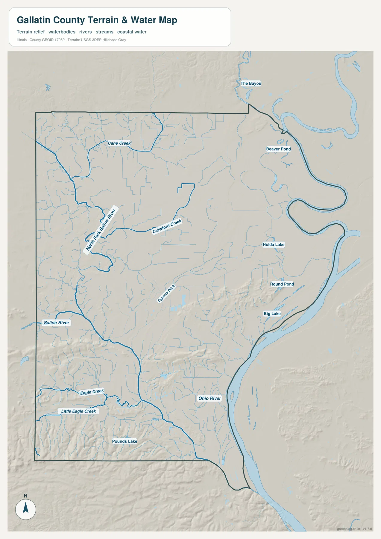
Relief shading behind the water features is important because it shows that the channels occupy lower ground rather than floating on an abstract flat surface. The Ohio River side forms a broad low corridor, while the southern and southwestern creeks cut through more uneven terrain. This map is still a geographic reference rather than a flood, navigation, parcel, or access product. It does not provide real-time river stages, flood probabilities, water depths, boat access, fishing rules, or property boundaries, so those questions require current information from USGS and the relevant local or state agencies.
Most of Gallatin County is low, but the southern ridges rise sharply above the river plain
The elevation map reports a county-wide mapped range of about 100 to 280 meters and a mean of 118 meters. Green classes cover most of the map, especially the east and northeast near the Ohio River. The strongest high-elevation colors appear in the southwest, where dark brown ridges stand out from the surrounding lowlands. Additional higher ridges appear across the southern interior and in an isolated east-central group, creating more local relief than the road map alone would suggest.
The low eastern side closely matches the water map. Wide green terrain follows the Ohio River bends, and lower corridors extend inland along the Saline River system. In the southwest, by contrast, creek valleys are surrounded by much higher ground, producing a stronger pattern of ridges and narrow hollows. The southern point of the county remains comparatively low near the river even though higher terrain rises immediately to the west. This combination of low river plain and nearby ridges is one of the clearest geographic contrasts in the supplied Gallatin County map set.
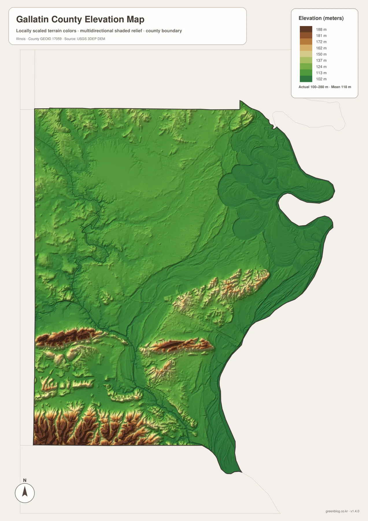
This relief layer is intended for county-scale comparison rather than engineering or survey work. The color breaks group elevation ranges to make broad differences easier to see, so they should not be interpreted as exact boundaries between terraces or ridges. A specific parcel, road grade, building site, or drainage project requires source elevation data and, when necessary, professional survey measurements. The USGS 3D Elevation Program is the appropriate starting point for more detailed elevation information.
Choose the Gallatin County file by the question you need to answer
For road and place orientation, the general county map is the best first choice. It keeps Shawneetown, Equality, Junction, Ridgway, Omaha, and New Haven visible while also showing the county outline and major route numbers. The city index is better when the task is to compare only the six ranked communities without the extra road detail. For rivers, creeks, ponds, and lakes, the terrain-and-water map carries far more useful labels, while the elevation map is the clearest way to compare the low Ohio River side with the higher southern ridges.
A reader tracing the Route 13 corridor from Equality to Shawneetown may need only the general map. Someone explaining why eastern Gallatin County appears broad and low will get more from the water and elevation maps together. The city map is a quick way to locate New Haven or Omaha before returning to the road map for route numbers. Using the maps this way keeps each view focused on the information it presents best instead of treating all four as interchangeable versions of the same graphic.
The WebP images in the article are reduced previews for fast browsing. The downloadable archive contains the original JPG versions of the county, city, water, and elevation maps, each measuring 2572 × 3638 pixels. Those files are more suitable when small creek labels or route numbers need to be enlarged, when a map will be printed, or when several neighboring counties are being compared at similar scale. The archive does not include GIS layers, editable vector data, or the underlying source DEM.
Frequently Asked Questions
How are Shawneetown and Old Shawneetown shown on the supplied maps?
They are labeled as separate mapped places. Shawneetown appears near Route 13 and ranks first in the supplied city index, while Old Shawneetown is farther southeast near the Ohio River and ranks sixth. The article does not invent a historical explanation for the distinction; it preserves the separate names and locations shown in the supplied map set.
Why does the eastern side look so low on the elevation map?
The broad Ohio River side is shown in the lowest green elevation classes, while much higher ridges occur in the southwest and parts of the southern interior. The water map reinforces that contrast by showing the Ohio River, ponds, lakes, and low drainage corridors along the eastern side. The elevation layer is useful for broad comparison but should not be used to determine exact site elevations or flood risk.
Can the water map be used for flood decisions or boat navigation?
No. It is a reference map for the relative positions of the Ohio River, Saline River, North Fork Saline River, named creeks, ponds, and lakes. It does not contain live water levels, flood probabilities, channel depths, access rules, navigation hazards, or property boundaries. Use current USGS and local or state agency information for safety and access decisions.
Map File Information
The ZIP contains the Gallatin County road-and-place, ranked city, terrain-and-water, and elevation maps as high-resolution JPG files.
- Included Files: County, city, water, and elevation maps
- Printable Size: 2572 × 3638 pixels each
Related Maps
Sources and Reference Data
The road, city, water, and elevation descriptions above are based primarily on the supplied Gallatin County map set. The following official resources provide additional county context and authoritative source data for boundaries, roads, hydrography, and elevation.
- Gallatin County – About Gallatin County – official county history and local background
- Gallatin County Highway Department – county road administration and road-jurisdiction map information
- U.S. Census Bureau TIGER/Line Shapefiles – county boundary and geographic data
- USGS National Hydrography – hydrography reference for rivers, streams, and water bodies
- USGS 3D Elevation Program – elevation and terrain source data
Green Map creates custom-edited map images using open geographic data sources such as geoBoundaries, Natural Earth, OpenStreetMap, and government open data.
These maps are edited visual materials, not raw data files, and are provided for education, documents, presentations, and graphic reference.