Palm Beach County Map pages make the county’s east-west contrast easy to see. The Atlantic side contains a long, closely spaced chain of cities such as Jupiter, West Palm Beach, Boynton Beach, Delray Beach, and Boca Raton, while the western half opens into the Glades around Belle Glade, broad lowlands, and a dense network of canals. This page uses a county map, a city map, and a water map to explain that contrast without forcing every detail into one crowded image. A ZIP containing three high-resolution A3 JPG maps is available from the download box below.
The maps are especially useful because Palm Beach County changes character quickly as you move inland. Near the coast, cities and north-south roads are packed into a narrow corridor. West of Royal Palm Beach and Wellington, the map becomes much more open, with fewer urban labels and far more straight canals. Reading the three maps together helps separate the county’s urban geography from the water-managed Glades landscape.
Table of Contents
From the Atlantic city corridor to the western Glades
The full county map makes the coastal concentration obvious. Jupiter and Palm Beach Gardens sit near the north end, followed southward by Riviera Beach, West Palm Beach, Palm Beach, Lake Worth Beach, Boynton Beach, Delray Beach, and Boca Raton. These places occupy a relatively narrow eastern strip compared with the county’s full width. The result is a long urban edge beside the Atlantic rather than a county whose settlements are evenly spread from east to west.
Move west and the pattern changes. Belle Glade appears as the strongest western city label, while the surrounding Glades have fewer towns, broader open areas, and long straight canals. The western edge also reaches the Lake Okeechobee side of the county. This is why Palm Beach County can look almost like two different regions on the same map: an urban Atlantic corridor and a much more open inland landscape.
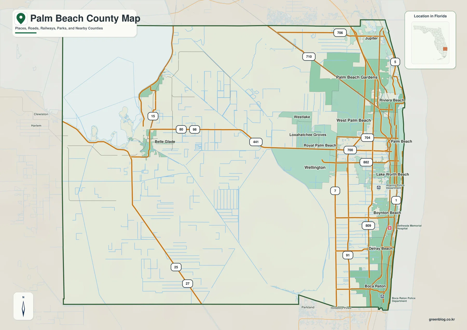
The middle of the county forms a useful transition zone. Westlake, Loxahatchee Groves, Royal Palm Beach, and Wellington sit between the tightly packed coastal communities and the western lowlands. SR 80 provides one of the clearest east-west references, running from the West Palm Beach area toward Belle Glade. US 441 and SR 7 form major north-south references farther inland. Together, those routes help explain how the urban east connects to the more open western half.
The major cities line up along the eastern half
The city map ranks West Palm Beach, Boca Raton, Boynton Beach, Delray Beach, Wellington, and Jupiter as the six major cities shown. Five of them sit near the eastern side, while Wellington is set farther inland. That arrangement gives the city map a strong north-south pattern: Jupiter in the north, West Palm Beach near the middle, and Boca Raton toward the south, with Boynton Beach and Delray Beach between them.
West Palm Beach works as a useful central reference. North of it are Riviera Beach, Palm Beach Gardens, and Jupiter. South of it are Lake Worth Beach, Boynton Beach, Delray Beach, and Boca Raton. Wellington, Royal Palm Beach, and Loxahatchee Groves sit inland from the main coastal strip, so they help show how far the built-up area extends west before the map opens into the Glades.
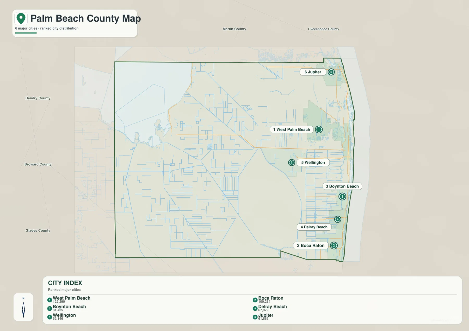
The road pattern reinforces the same geography. US 1 follows the eastern side, while major north-south routes farther inland parallel the coast. SR 704 crosses the West Palm Beach area, SR 706 helps orient the Jupiter area, and roads such as SR 809 and SR 882 connect communities in the southern part of the county. Because the road network is much denser in the east, it closely matches the concentration of city labels there.
Canals dominate the west while lakes dot the urban east
The water map reveals a feature that is easy to miss on a general road map: the western and central parts of Palm Beach County are crossed by an extensive network of straight canals. Ocean Canal and Hillsboro Canal are among the labeled waterways, and many additional channels form long, regular lines through the Glades. Their geometry contrasts sharply with the smaller lakes and local waterways found closer to the Atlantic-side cities.
Near West Palm Beach, Lake Mangonia and Clear Lake stand out. Farther south are Lake Clarke, Lake Osborne, and the Lake Ida Canal. Inland labels include Lake Wellington, Lake Banyan, and Lake Victoria. The Earman River appears toward the northeast. These water features are smaller and more scattered than the large western canal system, but they are closely interwoven with the built-up eastern corridor.
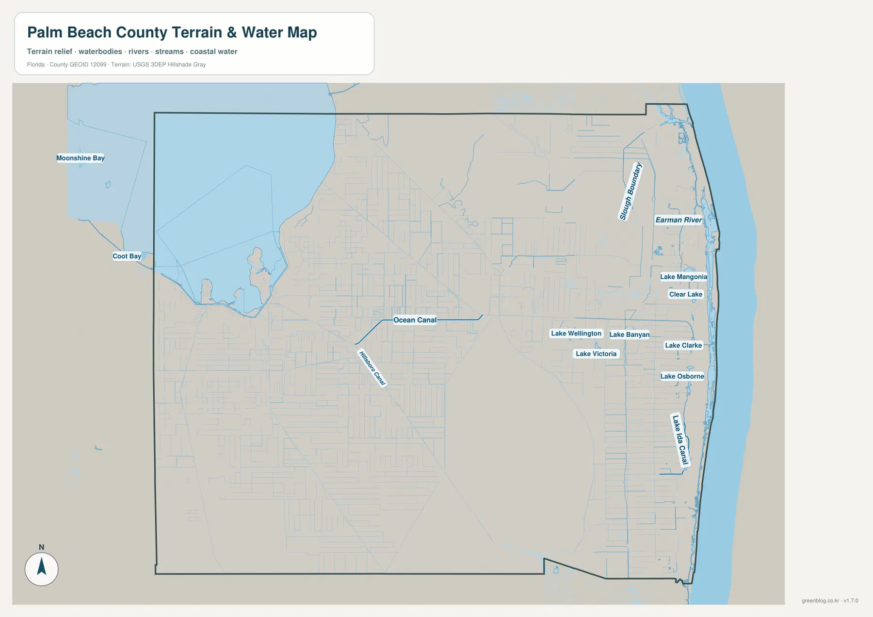
This difference matters when reading the western half of the county. Around Belle Glade and the Lake Okeechobee side, canals and roads often provide better orientation than city names because the settlements are farther apart. In the east, small lakes and canals sit inside a much denser road and city pattern. Comparing the two areas on the same water map makes the county’s geographic split especially clear.
Choose the map that matches the question
Use the county map first when you need the overall boundary, the east-west scale of Palm Beach County, or the relationship between Belle Glade and the Atlantic cities. The city map is cleaner when the goal is to compare West Palm Beach, Boca Raton, Boynton Beach, Delray Beach, Wellington, and Jupiter. The water map is the better choice for the canal grid, western lowlands, and the chain of lakes found closer to the coast.
This separation is also helpful for printing or classroom use. A road-and-boundary discussion benefits from the full county map, while the city map keeps attention on settlement patterns. The water map makes the Glades easier to explain because it removes much of the visual competition from urban labels and emphasizes the channels, lakes, and waterways instead.
A simple way to read Palm Beach County
The easiest rule to remember is that the eastern side is urban and closely connected, while the western side is larger, more open, and shaped by canals. The drive west from the West Palm Beach area toward Belle Glade crosses a major change in map pattern. Wellington and Royal Palm Beach still feel connected to the eastern urban network, but farther west the road spacing increases and the canal grid becomes the stronger visual feature.
Water is the second key. In the east, lakes and canals are embedded within cities and neighborhoods. In the west, the water-management network organizes broad stretches of land. Looking back and forth between the county map and the water map shows that Palm Beach County is much more than its Atlantic beaches and large coastal cities; the western Glades are an equally important part of its geography.
Frequently Asked Questions
Why are so many major Palm Beach County cities concentrated in the east?
The map shows West Palm Beach, Boca Raton, Boynton Beach, Delray Beach, Jupiter, and many other communities packed along the Atlantic side. The western half has fewer urban centers and is dominated more by the Glades, agricultural lowlands, and canal systems around Belle Glade.
Which road is useful for comparing West Palm Beach and Belle Glade?
SR 80 is one of the clearest east-west reference routes on the county map. It runs from the West Palm Beach area inland past the central communities and toward Belle Glade, making it useful for understanding the distance between the urban Atlantic corridor and the western Glades.
What should I look for first on the Palm Beach County water map?
Compare the long straight western canals, including Ocean Canal and Hillsboro Canal, with smaller eastern water features such as Clear Lake, Lake Mangonia, Lake Osborne, and the Lake Ida Canal. The contrast quickly shows how different the county’s western and eastern landscapes are.
Map File Information
The ZIP below contains the Palm Beach County general map, city map, and water map as high-resolution A3 JPG files.
- Included Files: county map JPG, city map JPG, water map JPG
Related Maps
- Arcadia Roads and Peace River | DeSoto County Florida Map
- Baker County Florida Map
- Between the Aucilla and Withlacoochee: Madison County Florida Map
Sources and References
- U.S. Census Bureau: Palm Beach County QuickFacts – county statistics and general reference.
- Palm Beach County municipalities – local-government reference.
- Palm Beach County boundary maps – county boundary reference.
- Florida Department of Transportation county highway maps – road and route reference.
- U.S. Fish and Wildlife Service: Loxahatchee refuge – western wetland context.
Green Map creates custom-edited map images using open geographic data sources such as geoBoundaries, Natural Earth, OpenStreetMap, and government open data. These maps are edited visual materials, not raw data files, and are provided for education, documents, presentations, and graphic reference.