Graham County lies in northwestern Kansas, where Hill City provides the clearest starting point for understanding settlements, roads, the South Fork Solomon River, and a broad west-to-east change in elevation. Hill City is the county seat and largest city, U.S. 24 crosses the central part of the county, and K-23 supplies the main north-south reference. Bogue lies east of Hill City and Morland to the west. High-resolution JPG versions of the maps shown on this page can be downloaded together from the ZIP box below. High-resolution map files are available for download in the section below.
The South Fork Solomon River is the county’s strongest natural landmark. It crosses the middle of Graham County from west to east while Bow Creek, Spring Creek, Sand Creek, Goon Creek, Brush Creek, Saline Creek, Wild Horse Creek, and other tributaries cut the surrounding uplands into narrow valleys. The elevation surface ranges from about 595 to 807 meters with a mean near 716 meters, and the county generally becomes lower toward the east.
Graham County also contains Nicodemus, one of the most important historic African American settlements on the western plains. The Kansas Historical Society identifies Hill City as the county seat and documents the 1877 founding of Nicodemus, while the National Park Service preserves the community as Nicodemus National Historic Site. The general map places Nicodemus near the eastern edge, adding a distinctive historical reference to the county’s modern settlement pattern.
Table of Contents
Hill City and the U.S. 24 corridor
Hill City is the easiest place to locate on the general county map. U.S. 24 runs east and west through the central settlement corridor, linking Morland, Hill City, and Bogue. K-23 extends south from Hill City into the sparsely settled southern half. A collection of numbered county and state routes fills the northern and southern rural areas, but a reader does not need to memorize them to understand the map.
Morland lies west of Hill City on the U.S. 24 corridor, and Bogue lies to the east. Nicodemus appears farther east near the county boundary. South of Hill City, settlement labels become scarce and the map is dominated by long rural roads and closely spaced drainage lines. The contrast shows why Hill City functions as such a strong geographic and administrative reference within a largely rural county.
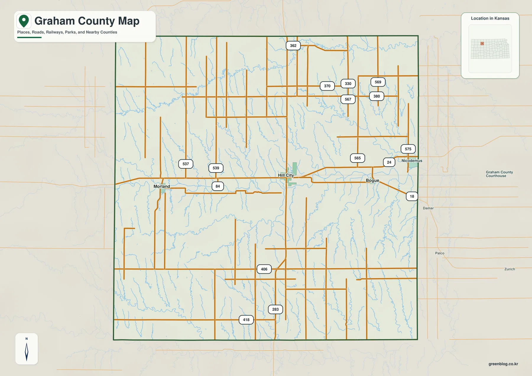
The western side contains long north-south roads crossing broad uplands, while eastern Graham County has a denser texture of small valleys. Northern roads also cross the Bow Creek drainage. This map is intended for county-scale orientation rather than live navigation, so current construction, winter weather, and local road conditions should be checked with up-to-date transportation information.
Bogue and Morland on opposite sides of Hill City
The city connection map simplifies the main settlement pattern to three communities. Hill City is the hub, Bogue is shown about 9 miles to the east in a straight line, and Morland about 12 miles to the west. Their nearly linear arrangement along the U.S. 24 corridor makes the central part of Graham County particularly easy to understand.
The map also ranks Hill City first, Bogue second, and Morland third among the communities shown. Those rankings are a quick guide rather than a permanent population statement because census and estimate dates change. Geographically, the important point is that Hill City lies between the two smaller towns and remains the county’s dominant administrative and service center.
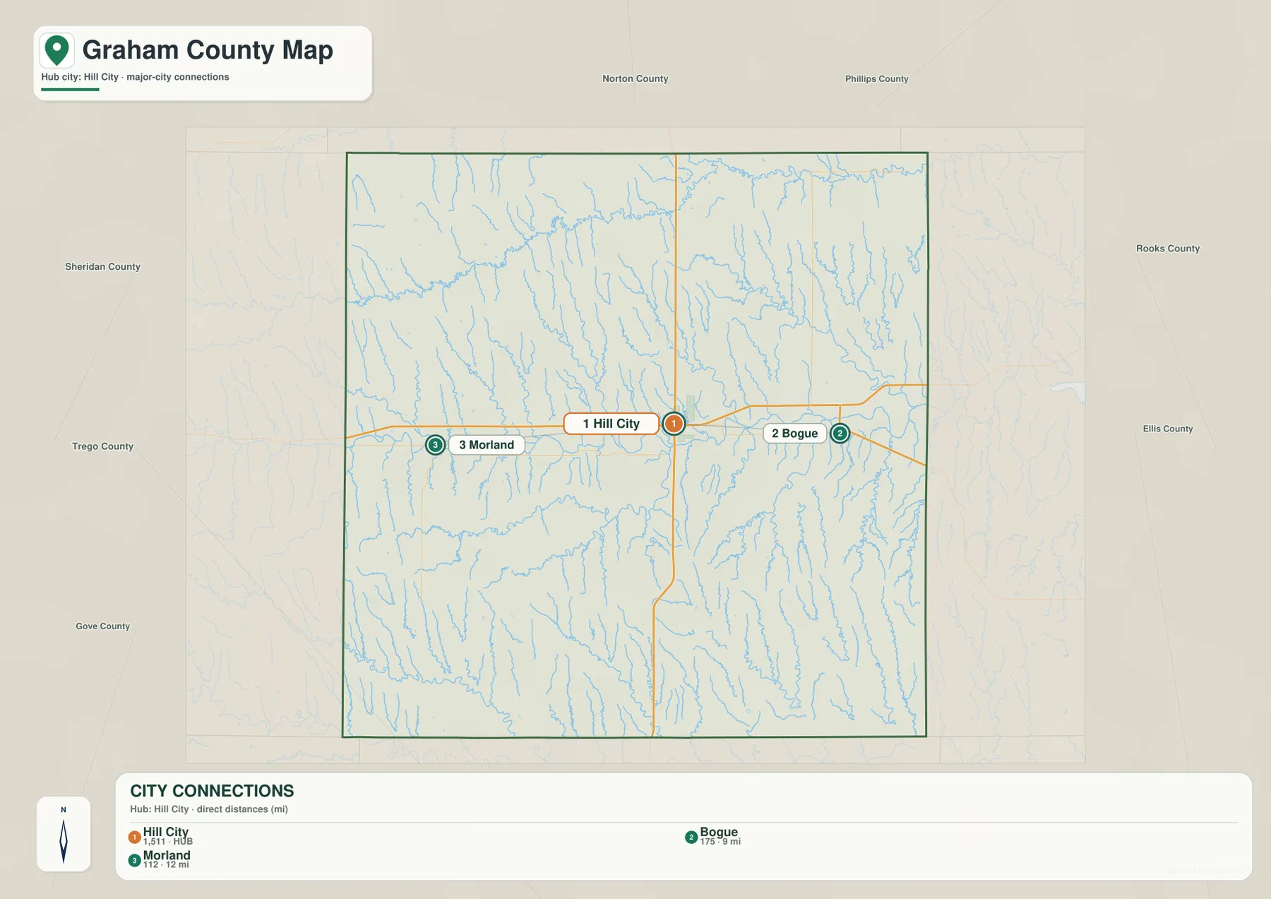
The Kansas Historical Society lists Hill City as the Graham County seat. Once the Hill City–Bogue–Morland relationship is fixed in mind, the water map becomes easier to interpret because the South Fork Solomon River follows the same central part of the county while tributaries descend from higher country to the north and south.
The South Fork Solomon River across central Graham County
The terrain and water map is organized around the South Fork Solomon River. The river enters from the west, crosses the county through the middle, and continues eastward through a broad low corridor. Numerous tributaries descend toward this central valley or neighboring drainage systems, giving the county a much more dissected surface than a simple road map suggests.
Bow Creek is the most prominent northern drainage, while Spring Creek cuts through the northeast. Sand Creek and Goon Creek descend through the central uplands. South of the South Fork Solomon River, Brush Creek forms another long valley, and Saline Creek and Wild Horse Creek drain different portions of the southern interior.
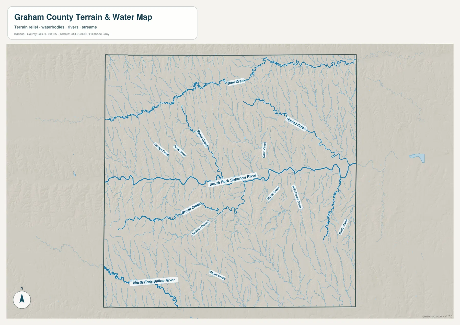
The North Fork Saline River appears near the southwestern edge, and Dune Creek is labeled along the southeastern side. Happy Creek, Jackson Branch, Youngs Creek, and Rock Creek add smaller local valleys. This map is a geographic reference rather than a live hydrology product, so current streamflow, flood conditions, or water quality should be checked through USGS or responsible local agencies.
A 595–807 meter decline from western uplands to eastern valleys
The elevation map shows an actual county range of approximately 595 to 807 meters and a mean elevation near 716 meters. Brown and orange colors dominate the west and southwest, marking the highest broad surfaces. Moving east, the map shifts through tan and yellow-green into much larger areas of green, revealing a clear overall decline in elevation.
The South Fork Solomon River forms the most obvious low band across the middle of the county. Tributaries create narrow green corridors that climb north and south into the uplands. Bow Creek and Spring Creek make the northeastern terrain especially dissected, while Dune Creek and many smaller streams shape the southeastern side.
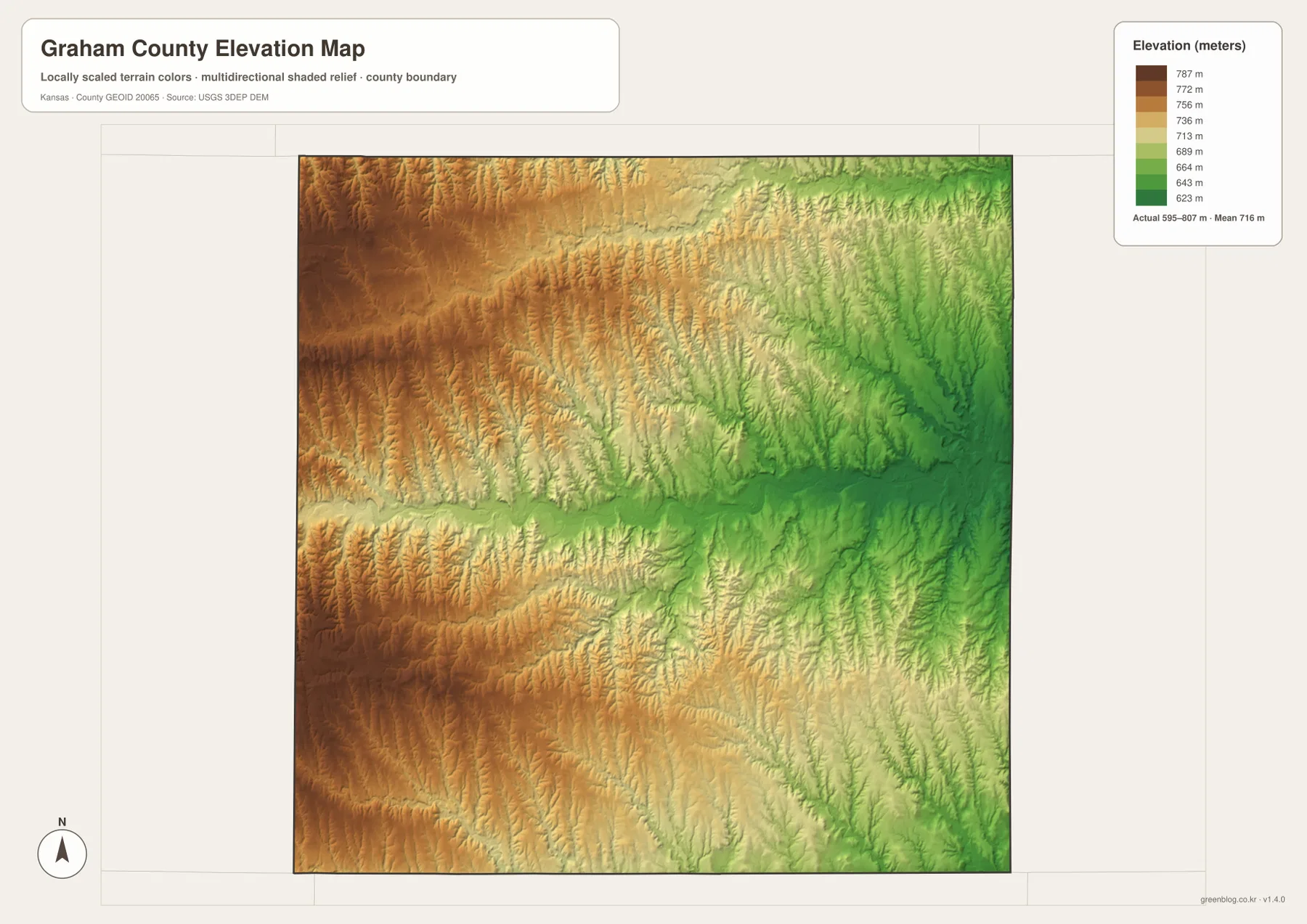
This elevation surface is intended for county-scale comparison rather than survey-grade measurement. It should not be used to establish exact parcel elevations, design drainage, or replace engineering and legal survey data. Its value is visual context: Hill City sits near the central river system, while the county’s western edge rises substantially above the eastern drainage country.
Nicodemus and Graham County’s African American settlement history
Nicodemus gives Graham County a historical identity that is unusual among western Kansas counties. The Kansas Historical Society records that the town was established in 1877 by African American settlers, many of whom came from Kentucky seeking greater freedom and opportunity after the Civil War. The community became one of the most important Black settlements on the Great Plains.
Today the National Park Service preserves key parts of the town as Nicodemus National Historic Site. Although Nicodemus is small on a modern county map, its historical importance is much larger than its present population would suggest. Its location near the eastern edge also provides a useful geographic counterpoint to Hill City, Bogue, and Morland along the main U.S. 24 corridor.
The surrounding map shows Nicodemus in lower, more strongly dissected eastern terrain than the high western side of Graham County. Combining that landscape with the settlement history helps explain why a county map can be more than a road reference: it also places nationally significant historic communities within the physical geography that shaped daily life.
Using the maps for study, printing, and county orientation
For basic orientation, begin with Hill City and U.S. 24, then place Morland to the west and Bogue to the east. For physical geography, follow the South Fork Solomon River across the county and compare Bow Creek, Spring Creek, Brush Creek, Saline Creek, and the smaller tributary valleys. The elevation view then explains the broad transition from higher western country to lower eastern drainage.
The high-resolution JPG files in the ZIP are better suited than the reduced web previews for printing, classroom projects, local-history materials, and close inspection of labels. They are useful for county overviews and regional comparison, but current roads, live stream conditions, parcel boundaries, and exact elevations should always be checked against the latest authoritative sources when those details matter.
Frequently Asked Questions
Where is Hill City on the Graham County map?
Hill City sits near the center of Graham County and serves as the county seat and largest community. U.S. 24 runs east and west through the area, while K-23 extends south. Bogue is about 9 miles east and Morland about 12 miles west in straight-line distance.
What role does the South Fork Solomon River play in the county terrain?
The South Fork Solomon River forms the largest continuous low corridor across central Graham County. Bow Creek, Spring Creek, Brush Creek, and other tributaries descend from surrounding uplands, and the elevation map shows the main river and tributary valleys as distinctly lower than much of the western county.
Can the 595–807 meter elevation map be used for surveying?
No. The elevation map is a county-scale visual reference for comparing uplands and valleys. Exact parcel elevations, construction design, drainage engineering, and legal surveys require purpose-built data and professional methods appropriate to those tasks.
Map File Information
Download the high-resolution JPG files corresponding to the Graham County general, city connection, terrain-and-water, and elevation maps in one ZIP archive.
- Included Files: Use only the versions confirmed in the article and supplied images
- File Type: Use the confirmed download contents
- Intended Use: Printing, education, presentations, and map-based projects
Related Maps
Sources and references
- Kansas Historical Society — Graham County, Kansas — county seat and county history
- Kansas Historical Society — Nicodemus, Graham County — African American settlement history
- National Park Service — Nicodemus National Historic Site — preservation and visitor information
- U.S. Census Bureau TIGER/Line — boundary, road, and geographic data resources
- USGS National Hydrography — hydrography and stream-network data information
- USGS 3D Elevation Program — elevation data information
Green Map creates custom-edited map images using open geographic data sources such as geoBoundaries, Natural Earth, OpenStreetMap, and government open data.
These maps are edited visual materials, not raw data files, and are provided for education, documents, presentations, and graphic reference.