Grant County lies in southwestern Kansas, where Ulysses provides an unusually clear center for understanding the county. Ulysses is the county seat and the only major city shown on the city map. U.S. 160 runs east and west through the area, while K-25 supplies the main north-south reference. The rest of the county is overwhelmingly rural, with broad High Plains surfaces cut by the North Fork Cimarron River and the Cimarron River. High-resolution JPG versions of the map set can be downloaded together from the ZIP box below. High-resolution map files are available for download in the section below.
The water map shows two major southern drainage corridors. The North Fork Cimarron River crosses the south-central part of the county in a long, winding valley, while the Cimarron River runs farther south near the county boundary. Wolf Creek and Bear Creek occupy the northwest, and Sand Arroyo Creek forms another western drainage. The elevation surface ranges from about 860 to 982 meters with a mean near 933 meters.
Grant County’s official profile describes the county as part of the High Plains of southwestern Kansas and notes that Ulysses became the county seat in 1888 and remains the county’s only incorporated town. That local description matches the maps especially well: one urban center sits inside a broad rural landscape, while the deepest visible relief is concentrated along river and creek valleys.
Table of Contents
Ulysses at the crossing of U.S. 160 and K-25
The general map makes Ulysses the obvious first reference. U.S. 160 provides the strongest east-west route through the city area, and K-25 continues south toward the lower part of the county. Once those two roads are fixed in mind, the numbered rural roads and smaller local routes become much easier to place.
The street and road pattern is densest around Ulysses. Outside the city, long straight roads spread across large agricultural blocks with relatively few settlement labels. Hickok and Ryus appear to the east, while Stano provides a small western reference. These labels are useful for orientation, but they do not form a chain of comparable cities like those found in more urbanized Kansas counties.
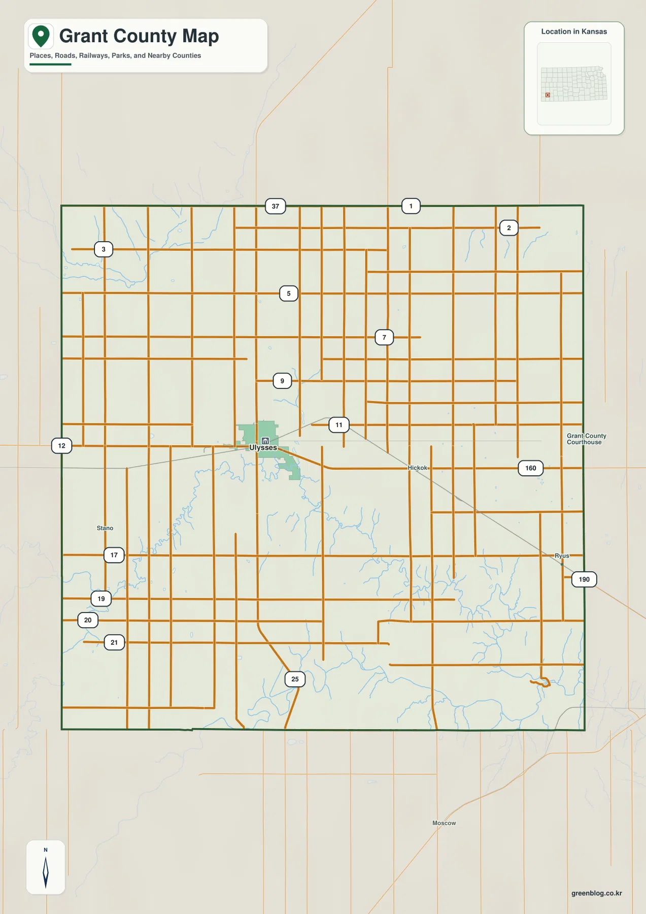
The rural road grid becomes more visually complex in the southeast because stream valleys interrupt the otherwise open plains. The north and west appear more regular, with long roads crossing broad uplands. This map is intended for county-scale orientation rather than live navigation, so current construction, unpaved-road conditions, high winds, and winter travel issues should be checked with up-to-date transportation information.
A city map with only Ulysses as the major urban center
The city distribution map is distinctive because only one major city is ranked: Ulysses. The map labels Ulysses as number one and shows a population value of 5,476, although population totals can change depending on the census or estimate used. The more durable geographic point is that no second incorporated city competes with Ulysses as the county’s urban center.
Grant County’s official profile states that Ulysses is the county’s only incorporated town. That fact explains why the city map looks different from maps of counties that contain several similarly sized communities. Instead of comparing connector distances between towns, the useful comparison here is between one concentrated urban area and the vast rural county that surrounds it.
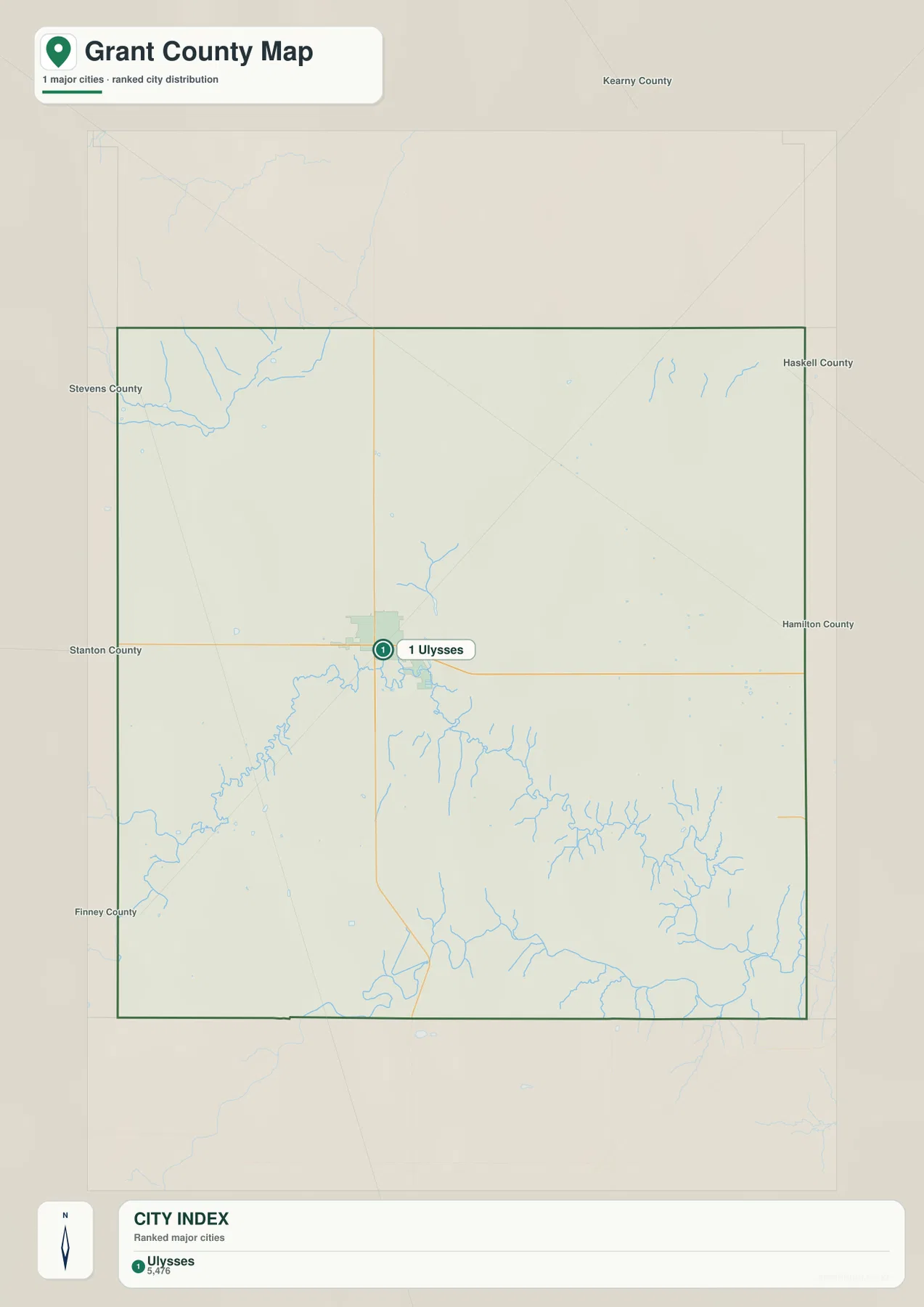
This one-city structure makes county orientation straightforward. A reader can locate Ulysses first, use U.S. 160 for east-west direction and K-25 for north-south direction, then move outward to rivers, creeks, farms, and historic sites. The city map therefore works less as a distance chart and more as a clear illustration of how strongly the county’s services and settlement are concentrated in Ulysses.
North Fork Cimarron River and the southern drainage corridors
The terrain and water map is dominated by the North Fork Cimarron River. The channel enters from the west, bends across the south-central part of Grant County, and continues toward the southeast. Numerous short tributaries feed the valley, and the elevation map shows the river as one of the county’s clearest low corridors.
Farther south, the Cimarron River forms another major drainage near the county boundary. In the southeast, small tributaries become tightly spaced between the North Fork and the main Cimarron channel, producing a much more dissected landscape than the broad uplands around Ulysses. The two river settings make southern Grant County considerably more varied than a simple road map suggests.
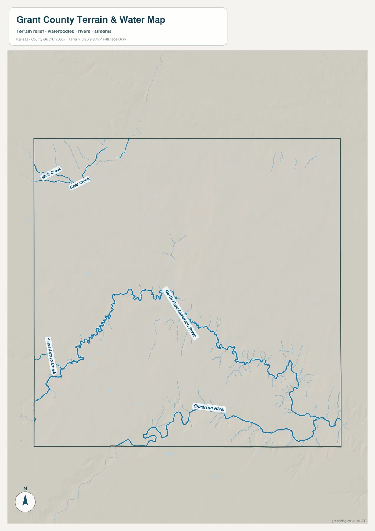
Wolf Creek and Bear Creek appear together in the northwest, while Sand Arroyo Creek marks another low route along the western side. These waterways are smaller than the Cimarron system but help explain local changes in terrain away from the main southern valleys. The map is a geographic reference rather than a live hydrology product, so current flow, flood conditions, or water quality should be checked through USGS or responsible local agencies.
An 860–982 meter High Plains surface cut by lower valleys
The elevation map shows an actual county range of approximately 860 to 982 meters and a mean elevation near 933 meters. The highest brown terrain is concentrated across much of the west and northwest. Moving east, the colors gradually shift toward yellow-green and green, indicating a broad decline in elevation across the county.
The North Fork Cimarron River cuts a long green valley through that sloping High Plains surface. The Cimarron River creates another low band along the south, and the southeast contains an especially dense pattern of tributary valleys. Wolf Creek and Bear Creek also form lower corridors in the northwest, though they are narrower and less extensive.
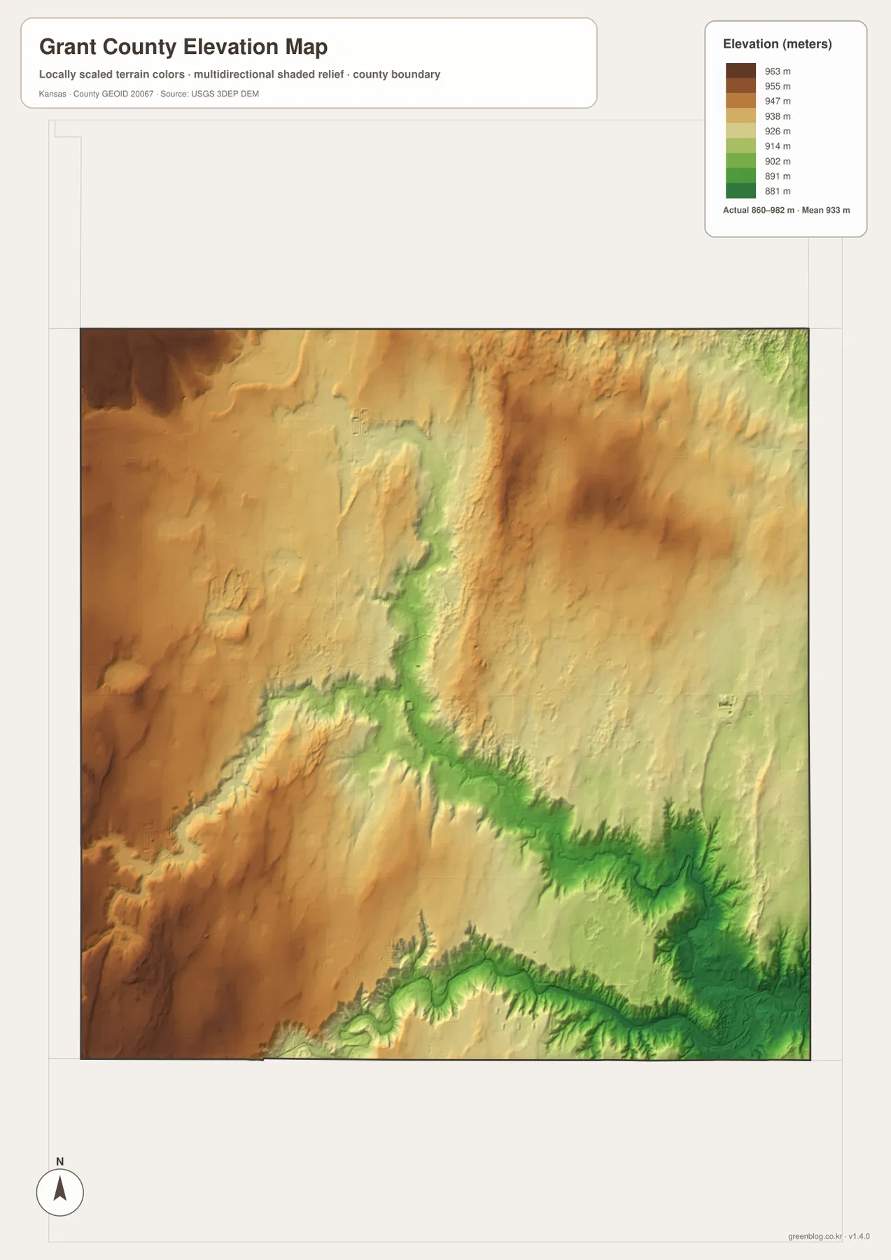
This elevation surface is intended for county-scale comparison rather than survey-grade measurement. It should not be used to establish exact parcel elevations, design drainage, or replace engineering and legal survey data. Its value is visual context: Ulysses sits on a broad upland surface, while the most dramatic terrain changes occur along the river corridors south of the city.
High Plains settlement, the Hugoton field, and Santa Fe Trail history
Grant County’s official profile describes a broad, mostly flat High Plains landscape and notes that the county lies over the Hugoton gas field, a major natural-gas region of the central plains. The map does not attempt to show every industrial facility, but that background helps explain the economic importance of a landscape that otherwise appears dominated by agriculture and long rural roads.
Southern Grant County also has a strong Santa Fe Trail connection. A Kansas Historical Society marker for Wagon Bed Springs describes the Lower Cimarron Spring near the Cimarron River as an important water stop on the dry route of the trail. In a region where long distances could separate dependable water sources, the river valley and spring had practical importance far beyond their small footprint.
The Kansas Historical Society also lists a Grant County section of the Santa Fe Trail known as Klein’s Ruts on the National Register of Historic Places. Visible wagon ruts preserve part of a route between the Arkansas River and Cimarron River country. Comparing those historic travel corridors with the modern U.S. 160 and K-25 road network shows how movement across the High Plains has always been shaped by water, distance, and terrain.
Using the maps for study, printing, and county orientation
For general orientation, begin with Ulysses, U.S. 160, and K-25. For physical geography, trace the North Fork Cimarron River and Cimarron River, then compare Wolf Creek, Bear Creek, and Sand Arroyo Creek. The elevation view explains why the river corridors stand out so clearly and shows the broad west-to-east decline across the High Plains surface.
The high-resolution JPG files in the ZIP are better suited than the reduced web previews for printing, classroom projects, local-history materials, and close inspection of labels. They are useful for county overviews and regional comparison, but current roads, live stream conditions, parcel boundaries, and exact elevations should always be checked against the latest authoritative sources when those details matter.
Frequently Asked Questions
Where is Ulysses on the Grant County map?
Ulysses sits slightly west of the county center and serves as the county seat and only incorporated town. U.S. 160 runs east and west through the area, while K-25 provides a strong north-south reference, making Ulysses the easiest place to begin county orientation.
Are the North Fork Cimarron River and Cimarron River the same channel?
No. The map shows them as separate major waterways. The North Fork Cimarron River crosses the south-central county, while the Cimarron River runs farther south near the county boundary. Both occupy terrain that is lower than much of the surrounding High Plains.
Can the 860–982 meter elevation map be used for surveying?
No. The elevation map is a county-scale visual reference for comparing uplands and valleys. Exact parcel elevations, construction design, drainage engineering, and legal surveys require purpose-built data and professional methods appropriate to those tasks.
Map File Information
Download the high-resolution JPG files corresponding to the Grant County general, city distribution, terrain-and-water, and elevation maps in one ZIP archive.
- Included Files: Use only the versions confirmed in the article and supplied images
- File Type: Use the confirmed download contents
- Intended Use: Printing, education, presentations, and map-based projects
Related Maps
Sources and references
- Grant County, Kansas official County Profile — Ulysses, High Plains setting, and county background
- Kansas Historical Society — Wagon Bed Springs — Cimarron River and Santa Fe Trail history in Grant County
- Kansas Historical Society — Santa Fe Trail, Klein’s Ruts — National Register trail segment in Grant County
- U.S. Census Bureau TIGER/Line — boundary, road, and geographic data resources
- USGS National Hydrography — hydrography and stream-network data information
- USGS 3D Elevation Program — elevation data information
Green Map creates custom-edited map images using open geographic data sources such as geoBoundaries, Natural Earth, OpenStreetMap, and government open data.
These maps are edited visual materials, not raw data files, and are provided for education, documents, presentations, and graphic reference.