Gray County lies in southwestern Kansas, where Cimarron provides the clearest starting point for understanding settlements, highways, the Arkansas River valley, and the High Plains surface. Cimarron is the county seat, Ingalls lies to the west, Ensign to the southeast, and Montezuma and Copeland anchor the southwestern half. U.S. 50 and U.S. 400 cross the northern-central corridor, while U.S. 56 serves the southern part. High-resolution JPG versions of the maps can be downloaded together from the ZIP box below. High-resolution map files are available for download in the section below.
The Arkansas River is the county’s strongest natural landmark. It enters from the west, runs past the Ingalls and Cimarron area, and continues east through a broad low corridor. Buckner Creek and South Fork Buckner Creek mark the northern side, while Crooked Creek and Mulberry Creek cut across southern areas. The elevation surface ranges from about 773 to 879 meters with a mean near 836 meters, showing higher western ground and lower terrain toward the river and eastern county.
The Kansas Historical Society places Gray County in the High Plains and Arkansas River Lowlands and records several distinctive episodes in local history: the county-seat struggle between Cimarron and Ingalls, the Santa Fe Trail split near Cimarron, and the failed Soule Canal irrigation project. These subjects fit the maps well because settlement and transportation have long followed the Arkansas River corridor while broad rural uplands extend away from it.
Table of Contents
Cimarron and the U.S. 50–U.S. 400 corridor
Cimarron is the most useful first reference on the general county map. U.S. 50 and U.S. 400 approach from the west near Ingalls and continue through the central corridor before leaving the county to the east. Roads also extend south from Cimarron into the broad agricultural interior, making the county seat a practical orientation point for both northern and southern Gray County.
Ingalls lies close to the Arkansas River west of Cimarron. Ensign marks the southeastern side, while Montezuma and Copeland provide two important references in the southwest. Pierceville appears just beyond the western boundary along the U.S. 50/U.S. 400 approach. Together these places show that Gray County has one administrative center but several smaller communities spread across a large rural area.
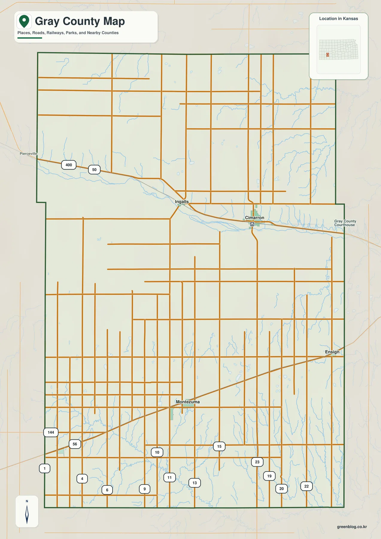
The northern half contains long straight roads interrupted by creek valleys, while the southern half becomes denser around Montezuma and local agricultural routes. Settlement and highway labels are most concentrated near the Arkansas River corridor. This is a county-scale orientation map rather than a live navigation product, so construction, unpaved-road conditions, high winds, and winter travel information should be checked separately.
Direct distances from Cimarron to the other major communities
The city connection map uses Cimarron as the hub and shows several straightforward distance comparisons. Ingalls is about 6 miles away in a straight line, Ensign about 12 miles, Montezuma about 16 miles, and Copeland about 24 miles. These figures communicate county scale and relative position; they are not driving mileage.
Ingalls and Cimarron form the closest pair and both sit near the Arkansas River corridor. Montezuma and Copeland lie farther southwest, while Ensign provides a southeastern reference. Because the towns do not form one continuous chain, using Cimarron as the hub is more useful than trying to memorize a simple west-to-east order.
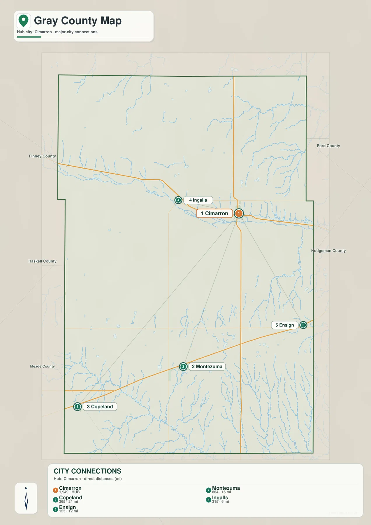
The Kansas Historical Society identifies Cimarron as the county seat. That role followed a long and sometimes violent competition with Ingalls in the late nineteenth century. The modern city map shows none of that conflict directly, but it makes the result clear: Cimarron remains the principal administrative reference while Ingalls and the southern communities provide secondary anchors.
Arkansas River lowlands and the creek systems around them
The terrain and water map is organized around the Arkansas River. The river crosses the central part of Gray County from west to east and forms the broadest continuous lowland in the county. Numerous short tributaries descend toward the river, especially from the north, creating a textured edge between the flat river corridor and the surrounding High Plains.
Buckner Creek runs across the northeastern part of the county, and South Fork Buckner Creek creates a separate eastern valley. A short segment labeled Pawnee River appears in the northwest. These northern drainages sit apart from the main Arkansas River valley and show that the northern uplands contain their own network of shallow channels.
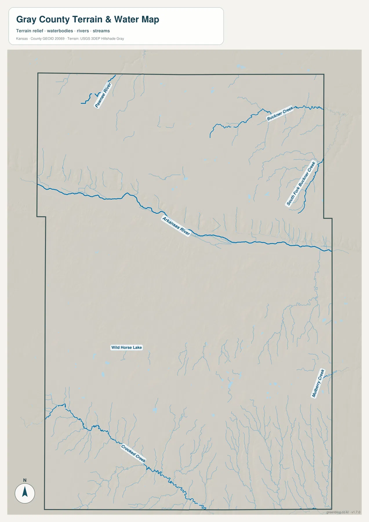
Crooked Creek crosses the southwest, and Mulberry Creek runs along the southeastern side. Wild Horse Lake is labeled in the south-central interior. These features make the southern half more varied than a simple road map suggests. The map is a geographic reference rather than a live hydrology product, so current streamflow, flood conditions, or water quality should be checked through USGS or responsible local agencies.
From 879-meter western uplands to 773-meter river and eastern lowlands
The elevation map shows an actual range of approximately 773 to 879 meters and a mean elevation near 836 meters. Brown and orange colors dominate much of the west and northwest, while yellow-green and green terrain becomes more common toward the east. The overall pattern is a broad decline from higher western High Plains toward lower eastern country.
The Arkansas River cuts a long green corridor through the middle of that gradient. Short tributaries descend from the uplands and produce narrow fingers of lower terrain along both sides of the river. The southeastern county is also strongly dissected by small channels, while the Crooked Creek area in the southwest mixes rolling higher surfaces with elongated valleys.
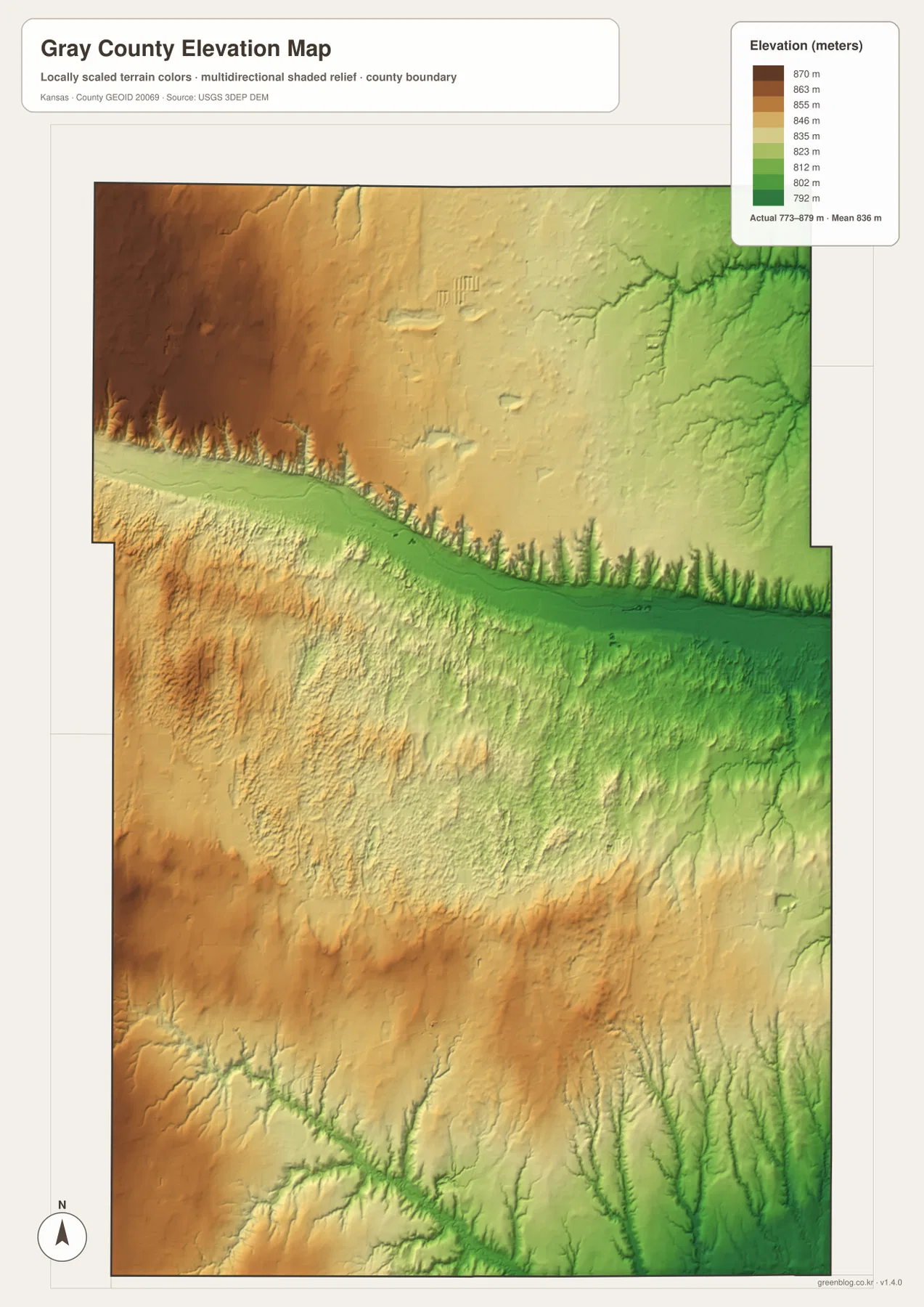
This elevation surface is intended for county-scale comparison rather than survey-grade measurement. It should not be used to establish exact parcel elevations, design drainage, or replace engineering and legal survey data. Its value is visual context: Cimarron and Ingalls can be placed near the main river lowland, while the western side rises noticeably above the eastern drainage country.
Santa Fe Trail history, the county-seat struggle, and Soule Canal
The Kansas Historical Society notes that the Santa Fe Trail divided near Cimarron. One branch continued west along the Arkansas River toward Bent’s Fort before turning south, while the shorter Cimarron Route crossed drier country to the southwest. The present road and river map helps explain why this location mattered: the Arkansas River provided a dependable geographic corridor through an otherwise broad High Plains landscape.
Cimarron and Ingalls later competed fiercely for the county seat. The dispute reached the Kansas Supreme Court and led to armed confrontations over county records. Cimarron ultimately became the permanent county seat. This history gives extra meaning to the short modern distance between the two towns shown on the city connection map.
The Soule Canal was another ambitious episode tied directly to the Arkansas River. Asa T. Soule backed a large irrigation project intended to carry river water through Gray and Ford counties, but the canal never achieved its promised success. The surviving history of the project illustrates how important water was—and remains—in a semi-arid county where farming and settlement depend on careful use of limited supplies.
Using the map files for study, printing, and orientation
For general orientation, begin with Cimarron and the U.S. 50/U.S. 400 corridor, then place Ingalls, Ensign, Montezuma, and Copeland around it. For physical geography, follow the Arkansas River first and then compare Buckner Creek, Crooked Creek, and Mulberry Creek. The elevation view explains why the river corridor stands out and shows the broad change from higher western ground to lower eastern terrain.
The high-resolution JPG files in the ZIP are better suited than the reduced web previews for printing, classroom projects, Santa Fe Trail history materials, and close inspection of labels. They are useful for county overviews and regional comparison, but current roads, live stream conditions, parcel boundaries, and exact elevations should always be checked against the latest authoritative sources when those details matter.
Frequently Asked Questions
Where is Cimarron on the Gray County map?
Cimarron sits slightly north of the county center and serves as the county seat. It lies close to the Arkansas River and the U.S. 50/U.S. 400 corridor. Ingalls is about 6 miles west and Ensign about 12 miles southeast in straight-line distance.
Why is the Arkansas River important to Gray County geography?
The Arkansas River forms the county’s largest continuous low corridor and passes near both Cimarron and Ingalls. Many short tributaries descend from the surrounding High Plains, and the elevation map shows the river valley as distinctly lower than much of the western county.
Can the 773–879 meter elevation map be used for surveying?
No. The elevation map is a county-scale visual reference for comparing uplands and valleys. Exact parcel elevations, construction design, drainage engineering, and legal surveys require purpose-built data and professional methods appropriate to those tasks.
Map File Information
Download the high-resolution JPG files corresponding to the Gray County general, city connection, terrain-and-water, and elevation maps in one ZIP archive.
- Included Files: Use only the versions confirmed in the article and supplied images
- File Type: Use the confirmed download contents
- Intended Use: Printing, education, presentations, and map-based projects
Related Maps
Sources and references
- Kansas Historical Society — Gray County, Kansas — Cimarron, county-seat history, High Plains, and Arkansas River Lowlands
- Kansas Historical Society — The Santa Fe Trail marker — Santa Fe Trail split near Cimarron
- Kansas Historical Society — Soule Canal — Arkansas River irrigation history in Gray County
- U.S. Census Bureau TIGER/Line — boundary, road, and geographic data resources
- USGS National Hydrography — hydrography and stream-network data information
- USGS 3D Elevation Program — elevation data information
Green Map creates custom-edited map images using open geographic data sources such as geoBoundaries, Natural Earth, OpenStreetMap, and government open data.
These maps are edited visual materials, not raw data files, and are provided for education, documents, presentations, and graphic reference.