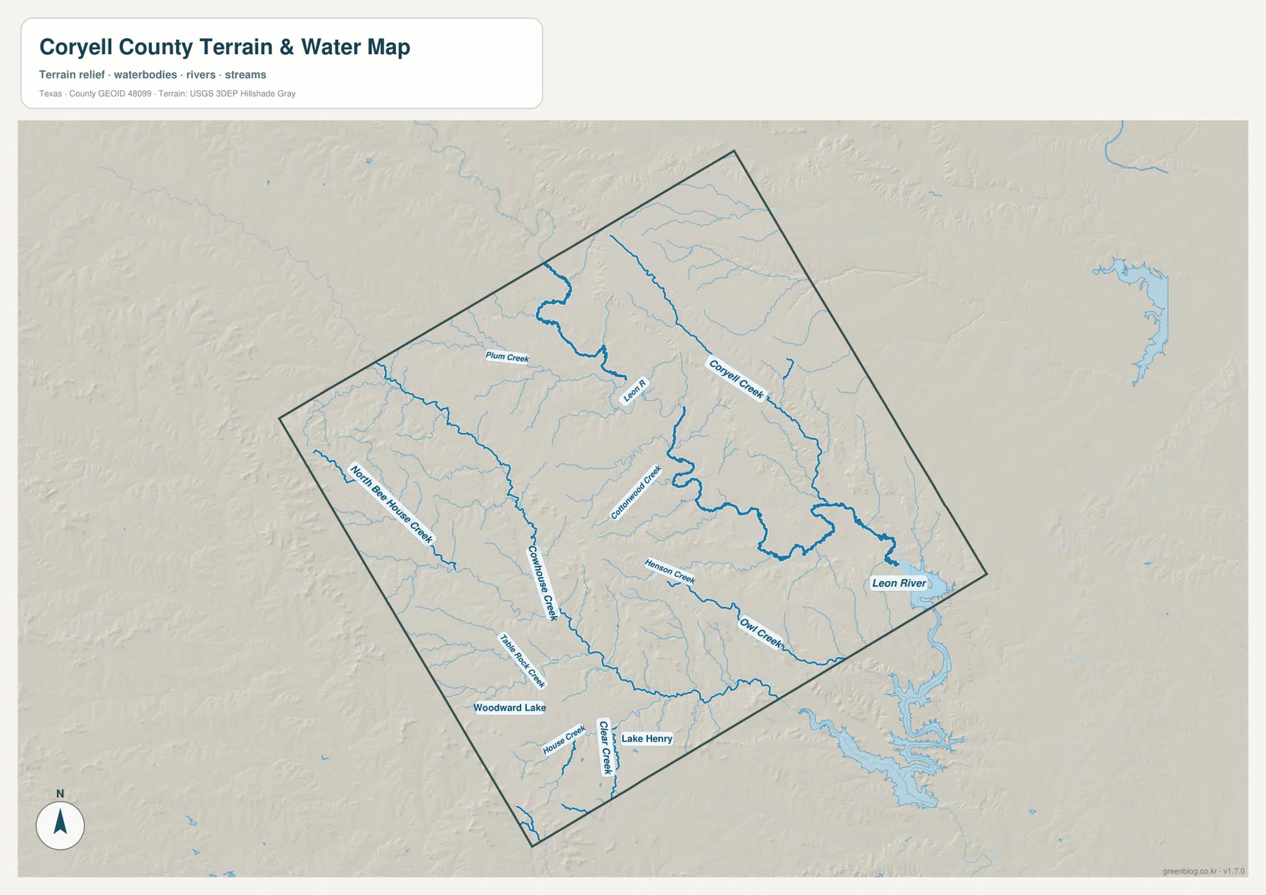
Coryell County in Central Texas changes noticeably from the high rolling terrain in the west to the lower Leon River and creek valleys in the east. Gatesville is the main road reference near the center-east, Copperas Cove and Fort Cavazos occupy the southwestern side, and smaller places such as Mound, Flat, McGregor, Evant, Oglesby, and South Mountain help define the county’s broad interior. US 84 provides the clearest east-west road through Gatesville, while route labels 36, 236, and 281 give additional orientation around the edges. The terrain-and-water map highlights Leon River, Coryell Creek, Cowhouse Creek, Cottonwood Creek, Henson Creek, Owl Creek, and several small lakes. Elevation ranges from about 181 to 455 meters with a mean near 291 meters. The county, city, water, and elevation maps shown here are also available together as four high-resolution A3 JPG files in the ZIP download.
Gatesville is the easiest place to establish orientation because roads and settlement labels concentrate there. Copperas Cove lies far to the southwest beside Fort Cavazos, while McGregor is close to the eastern boundary and Mound and Flat sit south and southeast of Gatesville. Evant occupies the northwestern side on the ranked city map, and Oglesby lies much farther east. Once those places are located, the physical maps explain the gaps between them: the west rises into rugged uplands, while Leon River and its tributaries cut broader low valleys toward the east.
Table of Contents
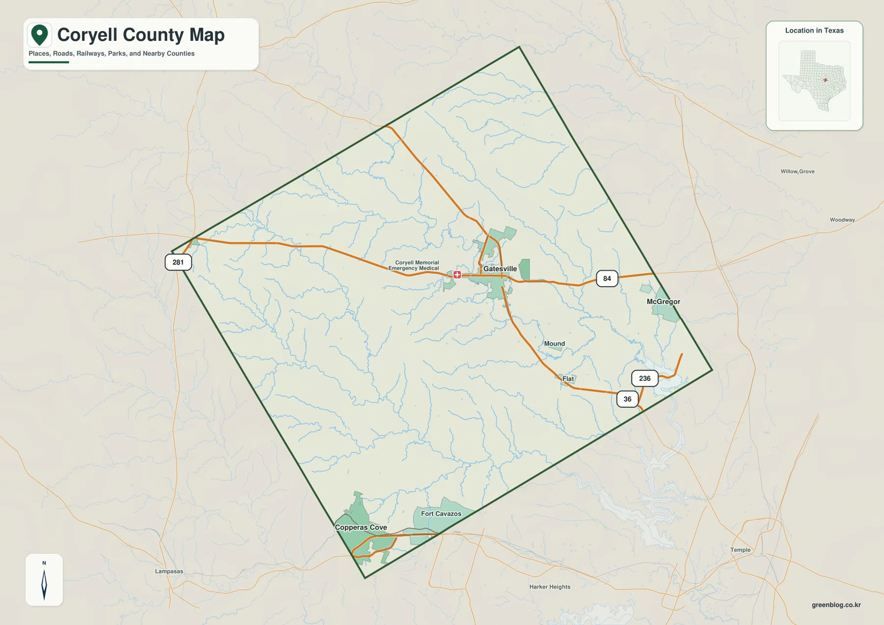
Gatesville Provides the Main Road Reference Across the Interior
Gatesville is the most obvious road and place reference on the general county map. US 84 passes through the city from west to east, and additional north-south roads converge around the same built-up area. McGregor is labeled near the eastern edge, providing an easy way to follow the US 84 direction beyond Gatesville. Coryell Memorial Emergency Medical is also marked west of the town center and gives the map another recognizable local reference.
South of Gatesville, Mound and Flat help orient the southeastern interior. Route labels 36 and 236 appear farther southeast, where roads cross a landscape filled with many small drainage lines. The general map can make the corridor look open and simple, but the water layer shows Henson Creek, Owl Creek, and numerous tributaries dividing the same area into separate valleys.
Copperas Cove has a very different setting in the southwest. Its built-up footprint sits next to Fort Cavazos, which occupies a large labeled area along the southern boundary. This southwestern corner feels more connected to the Fort Cavazos and outside urban region than to the lightly settled rural interior surrounding Gatesville.
Route 281 is labeled at the western edge and provides a useful reference for the high side of the county. Settlement labels are sparse there, while creeks and ridges become more prominent. The elevation map confirms that the western and west-central areas contain some of Coryell County’s highest terrain.
Copperas Cove and Gatesville Lead a Five-Place Ranked Distribution
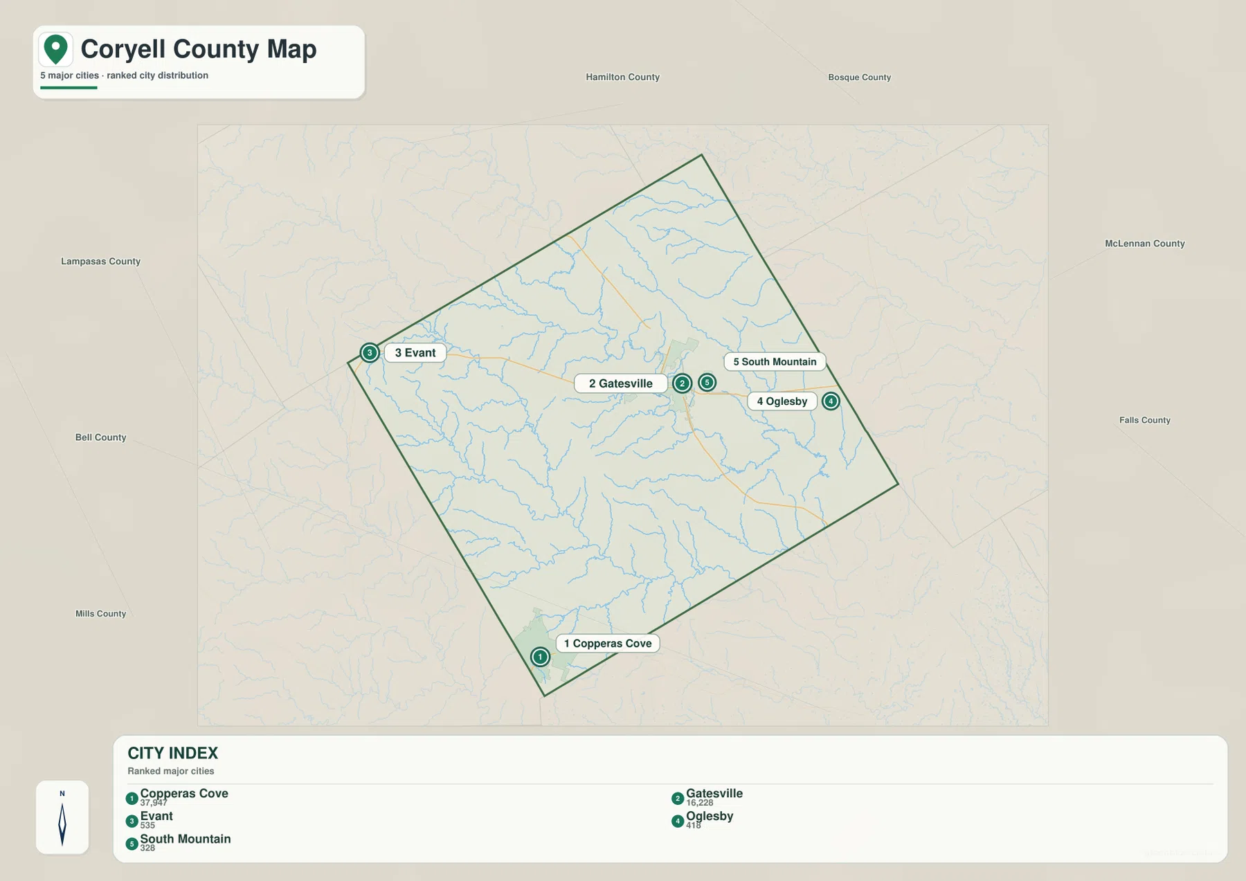
The ranked city map lists five places. Copperas Cove is first at 37,947, Gatesville second at 16,228, Evant third at 535, Oglesby fourth at 411, and South Mountain fifth at 328. The two largest figures are separated geographically, with Copperas Cove at the southwestern corner and Gatesville closer to the middle-eastern part of the county.
Evant sits by itself in the northwest, while Oglesby is near the eastern boundary. South Mountain is a small point east of Gatesville. The five-place pattern therefore stretches across much of the county rather than forming one dense cluster, and the wide spaces between the markers are important parts of the map.
No connector lines or mileage labels are shown on this ranked city layer. The CITY INDEX values should not be interpreted as straight-line distance, driving mileage, or travel time. The general county map is the better road reference, while the water and elevation layers explain the valleys and ridges between the ranked locations.
Neighboring county labels include Hamilton, Bosque, McLennan, Falls, Bell, Lampasas, and Mills counties. Evant helps locate the northwestern side toward Hamilton and Lampasas counties, Oglesby is closer to the McLennan County direction, and Copperas Cove sits near the Bell County side. These relationships show why the selected communities connect to different parts of Central Texas.
Leon River and Cowhouse Creek Cut the Central and Eastern Valleys
Leon River is the strongest water feature on the terrain-and-water map. It winds through the north-central interior and continues toward the eastern side, where the valley becomes broad and low. This river corridor is much more visually dominant on the water map than on the general road layer and provides a useful physical reference for the Gatesville–Oglesby side of the county.
The western and central interior contains several long named creeks. Plum Creek lies farther northwest, North Bee House Creek runs through the western side, and Cowhouse Creek follows a long south-central corridor. Numerous short tributaries enter these channels and divide the uplands into narrow ridges and valleys.
Cottonwood Creek and Henson Creek are prominent closer to the center and east, while Owl Creek follows a long southeastern valley. The southwestern portion includes Bee Rock Creek and Woodward Lake, with House Creek and Lake Henry labeled near the southern edge. These smaller features help connect the water map to the terrain pattern visible around Fort Cavazos and the rural southern interior.
This terrain-and-water image is intended for general geographic reference. It is not a flood-hazard map, parcel or legal-boundary map, depth chart, water-quality report, fishing-status guide, or navigation product. Those questions require specialized official data. For ordinary map reading, Leon River, Cowhouse Creek, Coryell Creek, Henson Creek, and Owl Creek provide the clearest framework for comparing drainage with roads and settlements.
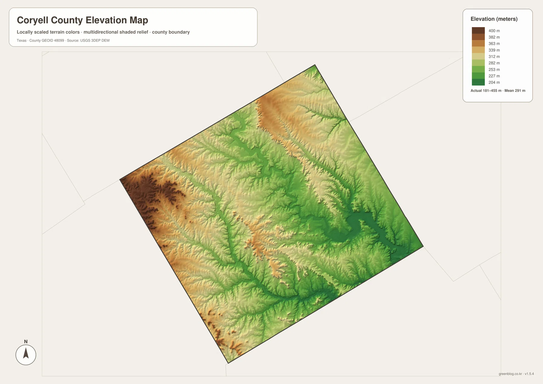
Elevation from About 181 to 455 Meters Separates the Western Uplands from the East
The supplied elevation map reports an actual range of approximately 181 to 455 meters and a mean near 291 meters. The highest dark-brown terrain is concentrated in the west and west-central county, with another broad high area across the north-central ridges. The east and southeast are much greener and generally lower, especially where the Leon River and major creeks have cut broad valleys.
The western high ground is not a smooth plateau. Narrow green and yellow valleys branch through the brown ridges, and many align with North Bee House Creek, Cowhouse Creek, and smaller tributaries on the water map. Moving from the western edge toward Gatesville lowers the overall surface, although local ridges remain common across the interior.
Eastern Coryell County contains some of the broadest low terrain. Leon River and Coryell Creek occupy long green corridors, while Henson and Owl creek valleys extend toward the southeast. Oglesby and the eastern boundary therefore sit in a noticeably lower physical setting than Evant and the western uplands.
This elevation surface is suitable for county-scale comparison, not survey or engineering measurement. It should not be used to determine the precise elevation of a house, parcel corner, road grade, or construction site. The 181–455 meter range and 291 meter mean are best treated as broad reference values for comparing the high western ridges, central creek valleys, and lower Leon River country.
Fort Cavazos and the Leon River Side Show Two Very Different County Settings
The strongest internal contrast appears between the Copperas Cove–Fort Cavazos side and the Leon River side of the county. The southwest combines a substantial developed and military footprint with high rolling ridges and short tributary valleys. The east is lower and more strongly defined by the Leon River and connected creeks.
Gatesville sits between those two settings and works well as a middle reference. It is the main road hub on the general map, but the water layer also shows multiple creek valleys around the city. On the elevation surface, Gatesville is lower than the western uplands but higher than parts of the broad Leon River lowland farther east.
Evant and Oglesby provide a similar comparison at smaller scale. Evant lies near the higher northwestern terrain, while Oglesby sits much closer to the lower eastern drainage country. The city map shows both as small ranked points, but the physical maps reveal very different landscapes around them.
Choose the File by Roads, City Ranking, Water, or Elevation
The general county map is the best single reference for Gatesville, Copperas Cove, Fort Cavazos, Mound, Flat, McGregor, and the major road labels. The ranked city map is cleaner when the goal is to compare the five selected places and their distribution. The terrain-and-water map is the best choice for Leon River, Cowhouse Creek, Coryell Creek, Henson Creek, and Owl Creek. The elevation map most clearly shows the difference between the western uplands and the lower eastern river valleys.
Small creek labels and minor road details can be difficult to read in a reduced browser preview. The original JPG files are more convenient for enlargement and printing. They also work well for side-by-side comparison with Hamilton, Bosque, McLennan, Bell, Lampasas, Mills, or other Central Texas counties when the same map type and a similar display scale are used.
The ZIP below contains four high-resolution A3 JPG files corresponding to the county, city, water, and elevation maps shown in the article. They can be enlarged for detailed label reading, printed for classroom or personal reference, or arranged with neighboring county maps for regional comparison.
Frequently Asked Questions
Which place ranks first on the supplied Coryell County city map?
Copperas Cove ranks first at 37,947 on the supplied CITY INDEX, followed by Gatesville at 16,228. Evant is shown at 535, Oglesby at 411, and South Mountain at 328. The map does not include mileage lines between the ranked points.
Where does Leon River cross Coryell County?
Leon River winds through the north-central and eastern part of the county. Its valley becomes broad near the eastern side, and Cottonwood Creek, Henson Creek, Owl Creek, and other tributaries connect to the larger drainage network.
Which part of Coryell County is highest on the supplied elevation map?
The west and west-central county contain much of the highest terrain. The supplied map reports an elevation range of about 181–455 meters with a mean near 291 meters, while Leon River and the eastern creek valleys occupy lower ground.
Sources and Reference Data
- U.S. Census Bureau TIGER/Line Shapefiles — official geographic boundary, road, and place data.
- USGS National Hydrography — official information about rivers, creeks, lakes, and hydrography.
- USGS 3D Elevation Program — official elevation and terrain data information.
- USGS The National Map Viewer — interactive access to boundaries, transportation, hydrography, terrain, and other geographic layers.
Map File Information
Download the Coryell County county, city, water, and elevation maps together as high-resolution A3 JPG files.
- Included Files: 4 maps
- File Type: JPG
Related Maps
- Williamson County Texas map
- Somervell County
- San Saba County Texas map
- Travis County Texas map
- Robertson County Texas map
Green Map creates custom-edited map images using open geographic data sources such as geoBoundaries, Natural Earth, OpenStreetMap, and government open data.
These maps are edited visual materials, not raw data files, and are provided for education, documents, presentations, and graphic reference.