Clark County occupies the eastern edge of Illinois, where rolling interior ground descends toward the Wabash River. Marshall is the clearest reference point on the map, with Martinsville and Casey extending southwest along the main road corridor, Westfield in the northwest, and West Union farther south. Between those communities, North Fork Embarras River and a dense network of creeks cut long valleys through the county before lower ground opens toward the Wabash side.
The maps on this page let you move from town and road orientation to straight-line city spacing, named waterways, and countywide elevation. High-resolution JPG originals of the four supplied Clark County maps are included in one ZIP download, making it easier to enlarge smaller creek labels, compare the city connections, or prepare a printed reference. These are county-scale explanatory maps rather than substitutes for live traffic, flood, parcel, navigation, or site-survey products.
The Illinois State Archives records Clark County as established in 1819 and Marshall as the county seat since 1838. Clark County’s official government site places the courthouse at 501 Archer Avenue in Marshall, matching the courthouse label on the supplied overview. That makes Marshall a useful starting point not only for the towns but also for comparing the higher western country with the lower terrain toward the Wabash River.
Table of Contents
Marshall sits at the main road crossing
The county overview places Marshall near the northeastern half of the county where a strong east-west road marked 40 meets the north-south Route 1 corridor. Following the westbound route leads toward Martinsville and then Casey. That diagonal chain—Marshall, Martinsville, Casey—is the easiest way to remember the county’s main settlement pattern before adding the smaller places and streams.
Casey sits near roads marked 49 and 70, while Westfield is in the northwest near 150. A route marked 400 appears along the far southwestern side. Route 1 continues south from Marshall toward West Union, which stands apart from the larger western towns. East of Marshall, the map becomes less town-centered and more dominated by creek lines and the irregular county edge approaching the Wabash River.
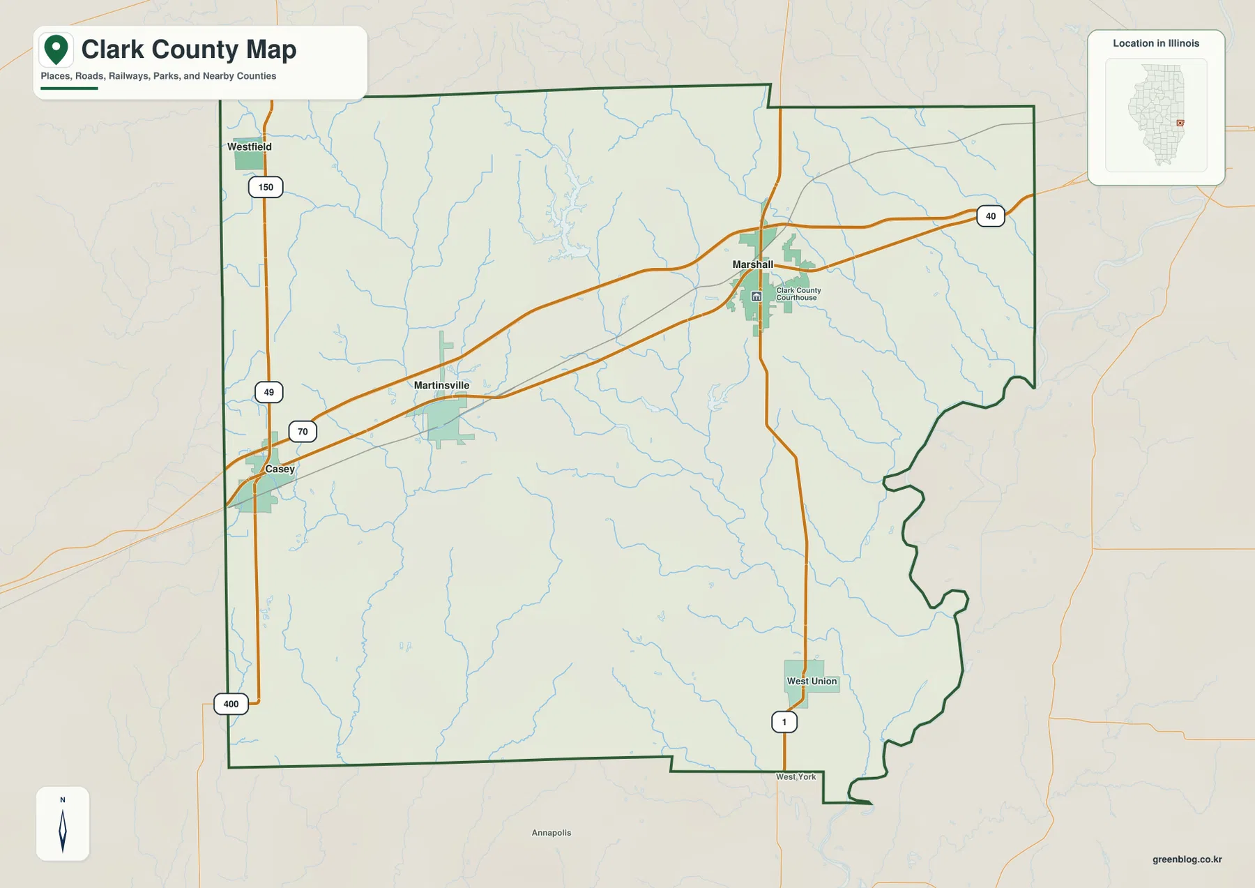
The stream layer changes the impression created by the roads. Several creeks cross the Marshall-to-Casey side, and a larger drainage line runs through the central and western county. Along the east, the county boundary bends with river terrain rather than remaining a straight survey line. Looking at towns and blue drainage lines together makes the contrast between the inland uplands and the Wabash-side low country much easier to recognize.
Marshall has been the county seat since 1838
The Illinois State Archives lists earlier county seats at Aurora and Darwin before Marshall became the seat in 1838. The current map reinforces that role with a Clark County Courthouse label in Marshall. Using the county seat as the fixed reference makes it easier to compare the westbound town corridor, the Route 1 line to West Union, and the lower drainage country toward the eastern boundary.
Three direct distances radiate from Marshall
The city-connections graphic strips away most road detail and makes Marshall the hub. Martinsville is shown about 11 miles to the southwest, while Casey is about 16 miles away in the same general direction. Westfield is also labeled about 16 miles from Marshall but lies northwest instead. The graphic explicitly calls these direct distances, so the numbers represent straight-line separation rather than the mileage a vehicle would travel on local roads.
The CITY CONNECTIONS panel also prints values of 4,040 for Marshall, 2,239 for Casey, 1,187 for Martinsville, and 415 for Westfield. No census year or statistical date is displayed beside those figures, so they are treated here as values printed on the supplied map rather than current population counts. The directional and distance information is the more dependable part of the graphic: 11 miles to Martinsville and 16 miles to both Casey and Westfield.
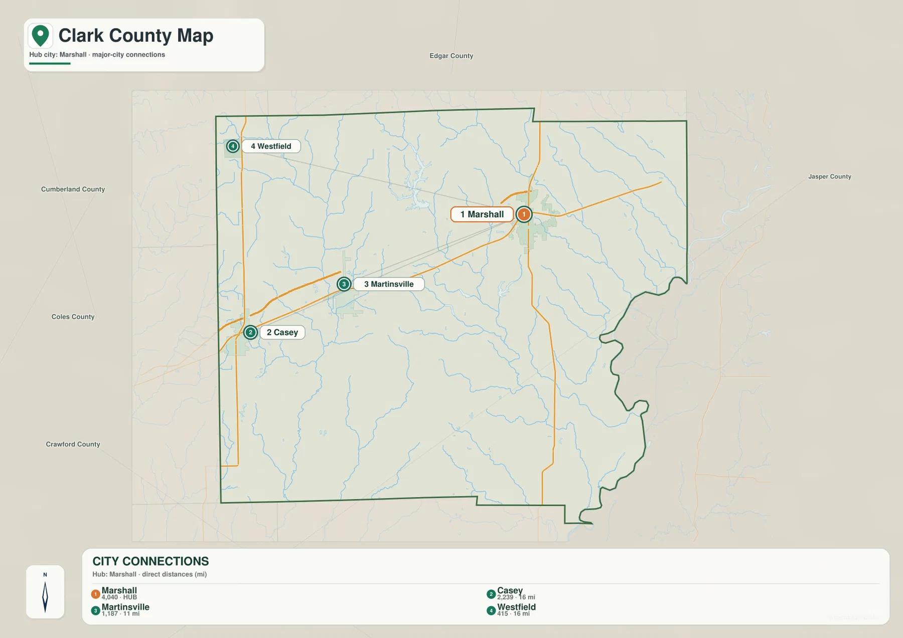
Straight-line spacing is useful when the goal is to compare where towns sit within Clark County, but it should not be converted directly into drive time. Roads bend, creek crossings affect routes, and the actual trip between two communities may be longer than the segment drawn on the city map. Current navigation or transportation information is the right source for route choice and road mileage.
The city panel is a location tool, not a driving table
This simplified graphic works especially well when explaining Clark County around Marshall without the distraction of every creek and route. For an actual trip, return to the detailed road map and then consult current navigation. The undated CITY CONNECTIONS values should likewise be kept separate from a current Census population table.
Embarras tributaries descend toward the Wabash
The terrain-and-water map is organized around two larger references: North Fork Embarras River on the western side and Wabash River at the eastern edge. North Fork Embarras enters from the northwest and continues south through the western half, collecting numerous smaller tributaries. Hurricane Creek and East Mill Creek cross the middle of the county, while Mill Creek and Snyder Creek form long drainage lines farther east and south.
The Wabash River follows the irregular eastern side, with Little Creek, Crooked Creek, Anderson Creek, and James Creek descending toward that lower river country. Craig Lake is labeled in the south-central area, and Willow Creek with Little Willow Creek appears farther southwest. Taken together, the map shows Clark County as a set of branching creek valleys between western uplands and the broad Wabash margin rather than a single flat surface.
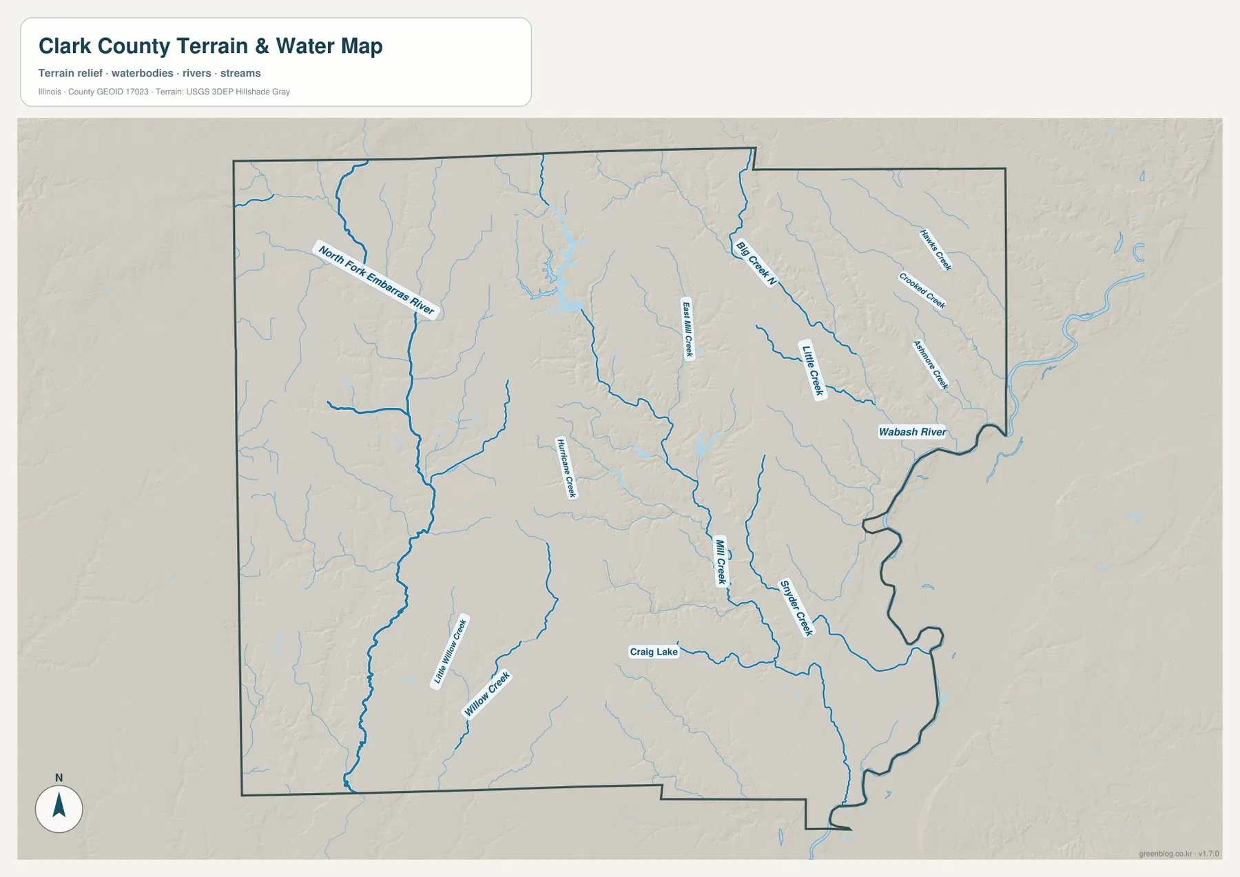
Lincoln Trail State Park gives a local example of that terrain south of Marshall. The Illinois Department of Natural Resources places the park about 2 miles south of Marshall, just west of Route 1, and identifies 146-acre Lincoln Trail Lake as the park’s focal water body. The park also contains wooded ravines, reinforcing what the terrain map suggests: eastern Clark County combines narrow creek valleys and upland slopes close to the larger Wabash lowland.
Use current agency data for water safety or flood decisions
This water map locates rivers, creeks, a lake, and surrounding relief at county scale. It does not show current Wabash River stage, flood-hazard zones, water depth, navigable channels, levee conditions, water rights, or legal access. Those questions require current USGS, Illinois DNR, or other responsible-agency information.
The west and northwest stand above the Wabash side
The elevation map gives Clark County a strong west-to-east contrast. Brown and orange high ground covers much of the northwest and western interior, but long green valleys cut through it along the major streams. Moving toward the center, the colors step down through yellow and light green. At the Wabash River edge, the broad terrain becomes dark green and distinctly lower.
The map reports an actual countywide elevation range of about 132 to 237 meters and a mean of about 178 meters. Its color legend uses bands from roughly 136 to 210 meters, while the separate “Actual” line records the wider minimum and maximum in the underlying county dataset. Those endpoints summarize Clark County as a whole; they should not be assigned directly to Marshall, West Union, Casey, Westfield, or an individual property.
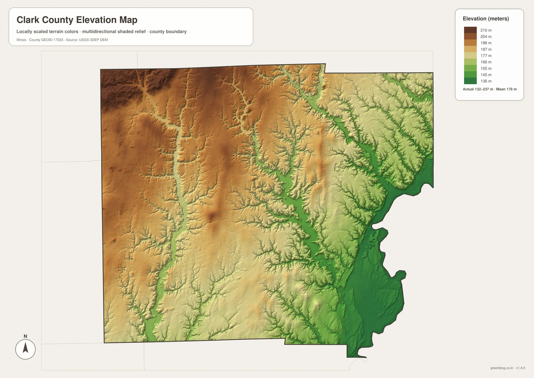
Comparing elevation with the water map makes the green corridors more meaningful. North Fork Embarras River occupies a long low valley through higher western ground, and Mill Creek and Snyder Creek trace additional depressions toward the east. The Wabash side contains the widest low area, creating a clear topographic contrast with the uplands around the western and northwestern county.
132 to 237 meters is a countywide range
Neither endpoint is a surveyed elevation for a named town. A building site, bridge, road grade, drainage design, or parcel requires point-specific source data or a professional survey. The colored elevation image is most useful for understanding the broad transition from higher interior terrain to lower Wabash River country.
Match the views around Marshall and the Wabash
A simple way to use the set is to keep Marshall fixed while changing what information you emphasize. On the overview, locate Marshall at the main road crossing and follow the town corridor southwest to Martinsville and Casey. The city graphic then reduces those relationships to 11- and 16-mile direct distances. Switching to the water map adds North Fork Embarras River, central creeks, and the Wabash River to the same geographic frame.
The elevation image completes the comparison by showing why the eastern edge looks different from the interior. Higher western ground is repeatedly cut by creek valleys, while the Wabash side opens into a much broader lowland. That combination of towns, direct spacing, drainage, and relief gives the Clark County files more value than using any one image by itself.
For current driving conditions, population, river stage, flood risk, or site elevation, use the appropriate current source rather than these county maps. Within their intended scope, however, the maps are well suited to printed reference sheets, lessons, presentations, and advance orientation around Marshall, Casey, the Embarras tributaries, and the Wabash River edge.
Frequently Asked Questions
Is the 16-mile Marshall-to-Casey label driving distance?
No. The city-connections graphic labels it as direct distance, meaning straight-line spacing between the mapped points. It also shows Martinsville about 11 miles from Marshall and Westfield about 16 miles away. Actual driving mileage can differ.
What is the county seat of Clark County, Illinois?
Marshall is the current county seat. The Illinois State Archives records Marshall as the seat from 1838 to the present, and the supplied overview labels the Clark County Courthouse in Marshall.
Does 132 to 237 meters give Marshall’s elevation?
No. The elevation image identifies 132–237 m as the actual range across the Clark County dataset and gives a mean of about 178 m. Exact elevation for Marshall or any specific road, property, or structure requires point-specific elevation or survey data.
Sources and Reference Material
The discussion above uses the supplied Clark County maps together with the official references below. For current road conditions, Wabash River stages, park rules, legal boundaries, or exact point elevations, consult the responsible agency’s latest data rather than relying on these explanatory county maps.
- Clark County Official Website – county government and Clark County Courthouse information in Marshall
- Illinois State Archives – Clark County – county establishment, name origin, and county-seat history
- Illinois DNR – Lincoln Trail State Park – park location south of Marshall, Lincoln Trail Lake, and local natural features
- USGS National Hydrography – river, stream, and lake reference data
- USGS 3D Elevation Program – elevation and terrain data
Map File Information
The ZIP download contains the high-resolution JPG originals for the Clark County overview, city-connections map, terrain-and-water map, and elevation map. Each landscape image measures 3,638 × 2,572 pixels, preserving smaller creek labels, road numbers, and elevation colors more clearly when enlarged or printed.
- Included Files: 4 high-resolution JPG maps
- Printable Size: 3,638 × 2,572 pixels each
Related Maps
Green Map creates custom-edited map images using open geographic data sources such as geoBoundaries, Natural Earth, OpenStreetMap, and government open data.
These maps are edited visual materials, not raw data files, and are provided for education, documents, presentations, and graphic reference.