Christian County in central Illinois is easiest to understand by starting at Taylorville. Pana lies to the southeast, Assumption to the east, Stonington to the northeast, and Mount Auburn farther north. West of Taylorville, Edinburg and Kincaid-Tovey provide another set of reference points, while Palmer, Morrisonville, and Harvel extend toward the southwest. The roads look fairly direct, but the map’s dense blue stream network shows that the county is crossed by many shallow valleys and drainage lines.
This page brings the four supplied Christian County views together: the detailed county sheet, a simplified city comparison, shaded water-and-terrain coverage, and elevation. The ZIP download contains the high-resolution JPG originals used here, so the same files can be enlarged for a classroom handout, printed reference page, or presentation graphic. They are best used to understand Christian County at county scale; live road status, parcel boundaries, flood conditions, navigation, and site-level elevation require separate current sources.
Christian County’s official website describes Taylorville as the major city in the heart of the county, and the Illinois State Archives lists Taylorville as the county seat from 1839 to the present. The supplied overview also labels the Christian County Courthouse in Taylorville, making the city a natural anchor for the surrounding towns, the Sangamon River system, Sangchris Lake, and the elevation changes visible across the county.
Table of Contents
Taylorville links the county in several directions
The county overview gives Taylorville the clearest visual weight. The Christian County Courthouse is labeled inside the city, and roads extend northwest toward Edinburg, west toward Kincaid and Tovey, northeast toward Stonington, east toward Assumption, southeast toward Pana, and southwest toward Palmer and Morrisonville. That pattern makes Taylorville a useful reference even before the individual route numbers are considered.
Mount Auburn sits well to the north, separated from the central urban cluster, while Stonington lies on the diagonal route northeast of Taylorville. Assumption is close to the eastern boundary and Pana is near the southeastern corner. On the western side, Route 104 enters near Tovey, and the southwest road marked 48 runs through the Morrisonville-Harvel side. The map also labels routes 29, 51, 16, 250, and 980, providing a practical frame for the main travel directions.
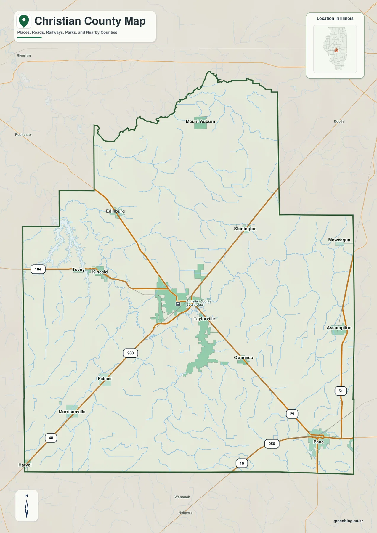
The blue drainage lines add an important layer to the road pattern. Streams are especially dense through the western and southwestern parts of the county, where they connect with the Sangchris Lake and South Fork Sangamon River area. Smaller tributaries also spread across the east and southeast. The road grid can look straightforward, but the drainage map makes it clear that the ground is divided by many shallow creek valleys.
Use Taylorville as the main orientation point
For a first look at Christian County, place Taylorville near the center, then find Pana southeast, Assumption east, Stonington northeast, and Kincaid-Tovey west. Add Mount Auburn in the north and Morrisonville in the southwest to complete the broad pattern. The overview is useful for location and direction, but current road closures, construction, lane details, exact parcel lines, and private-access rights require current transportation or property data.
Six ranked places show Taylorville as the largest map reference
The city-distribution map removes most road detail and highlights six places. Taylorville is ranked number 1, Pana number 2, Kincaid number 3, Assumption number 4, Edinburg number 5, and Morrisonville number 6. The printed CITY INDEX lists values of 10,646 for Taylorville, 5,217 for Pana, 1,278 for Kincaid, 1,205 for Assumption, 1,195 for Edinburg, and 926 for Morrisonville.
No census year or reference date appears beside the CITY INDEX values on this graphic, so the numbers are used here only as labels from the supplied image rather than as present-day population figures. The geography is still useful: Taylorville occupies the middle of the county, Pana lies southeast, Assumption east, Edinburg and Kincaid west, and Morrisonville southwest.
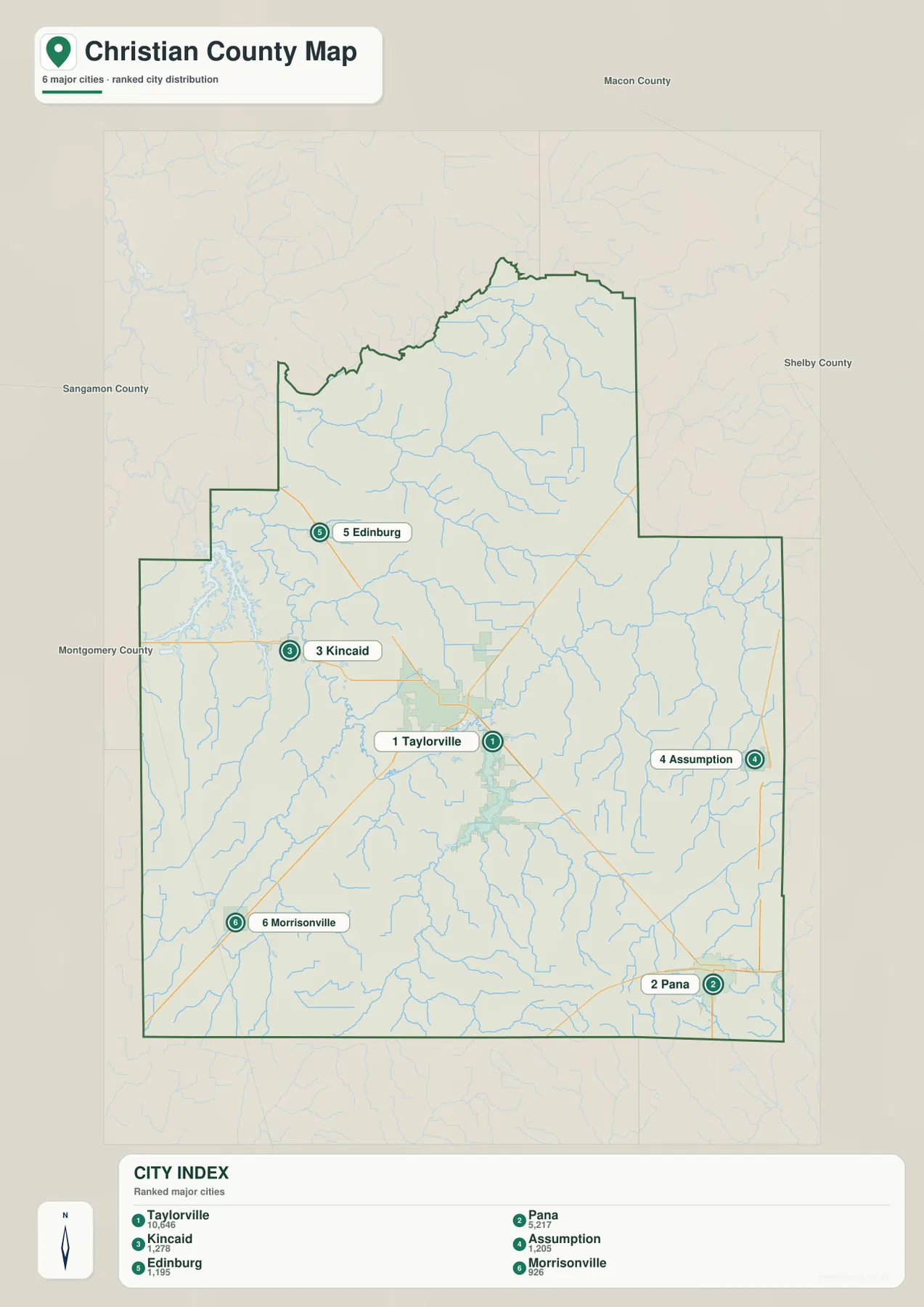
Once the road layer is stripped away, Christian County becomes easier to memorize by direction. Kincaid and Edinburg sit on the west side of Taylorville, Assumption is near the eastern edge, and Pana and Morrisonville pull the pattern toward the southeast and southwest. That simple arrangement is a useful mental guide before returning to route numbers, creek lines, and the more detailed county sheet.
The CITY INDEX is map data, not a current census table
For a current population table, consult a dated U.S. Census Bureau release rather than the undated index printed here. Because the map itself gives no year for these values, this article limits their use to comparing the six labels and their relative positions around Taylorville.
Sangamon River and Sangchris Lake shape the western drainage
The terrain-and-water map puts the county’s waterways in the foreground. Sangamon River is labeled along the northern side, with Mosquito Creek and Buckhart Creek below it. Sangchris Lake occupies the western edge, where long branches of water extend into the county. South Fork Sangamon River runs southward from that area and becomes one of the most prominent interior channels on the map.
Near the central-southern part of the county, Bertinetti Lake, Taylorville Lake, and Lake Taylorville appear close together. Flat Branch and Big George Branch cross the eastern side, while Clear Creek, Panther Creek, and Bear Creek occupy separate valleys in the southwest. Paragon Lake is labeled in the southeast. The map therefore shows several distinct water areas rather than one single dominant river corridor.
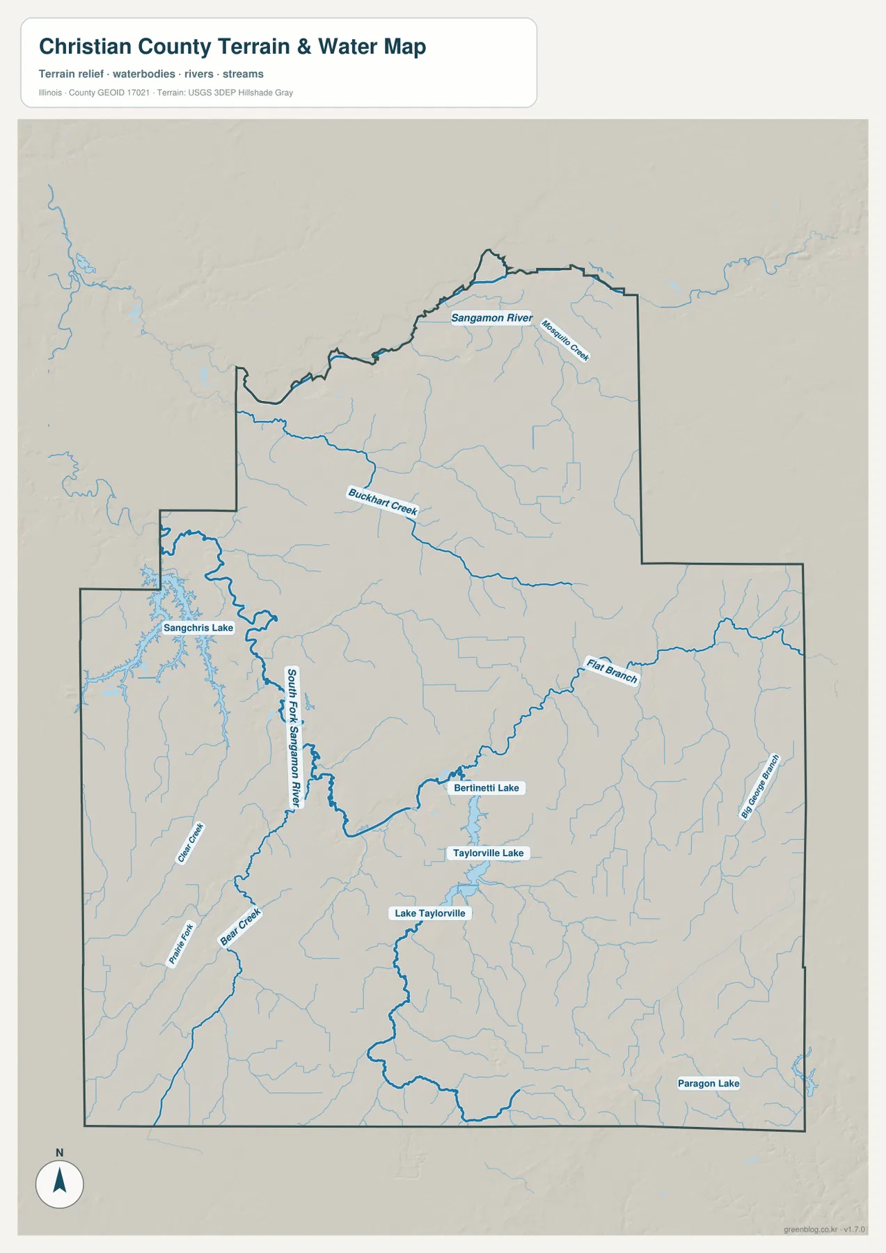
The Illinois Department of Natural Resources explains that Sangchris Lake extends into both Sangamon and Christian counties, which is the source of its combined name. IDNR also says the lake was created in 1964 by damming Clear Creek and now covers more than 3,000 acres with a long shoreline used for boating, fishing, camping, and other recreation. On the supplied map, the lake sits directly along Christian County’s western edge near the South Fork Sangamon River corridor.
The water map is not a flood, depth, or navigation product
The map shows where rivers, creeks, lakes, and surrounding terrain are located. It does not provide flood-hazard zones, live water levels, water depth, boating rules, navigable channels, water rights, or legal access. Current USGS, Illinois DNR, and other responsible agency information should be used for safety, flood, boating, or regulatory decisions.
Lower west-central valleys contrast with higher southeastern ground
The elevation map turns the water pattern into a clear color contrast. Sangchris Lake and the South Fork Sangamon River corridor are dark green, showing a broad band of relatively low ground through the west-central county. Smaller tributaries form additional narrow green cuts. A small area of higher ground appears in the north-central part, while the southeast rises into a wide yellow, orange, and brown zone.
The map reports an actual countywide elevation range of about 163 to 243 meters and a mean of about 189 meters. Its color legend uses bands from roughly 171 to 209 meters, while the separate “Actual” line records the wider minimum and maximum in the underlying county dataset. Those endpoints describe Christian County as a whole; they are not exact elevations for Taylorville, Pana, Assumption, or a specific property.
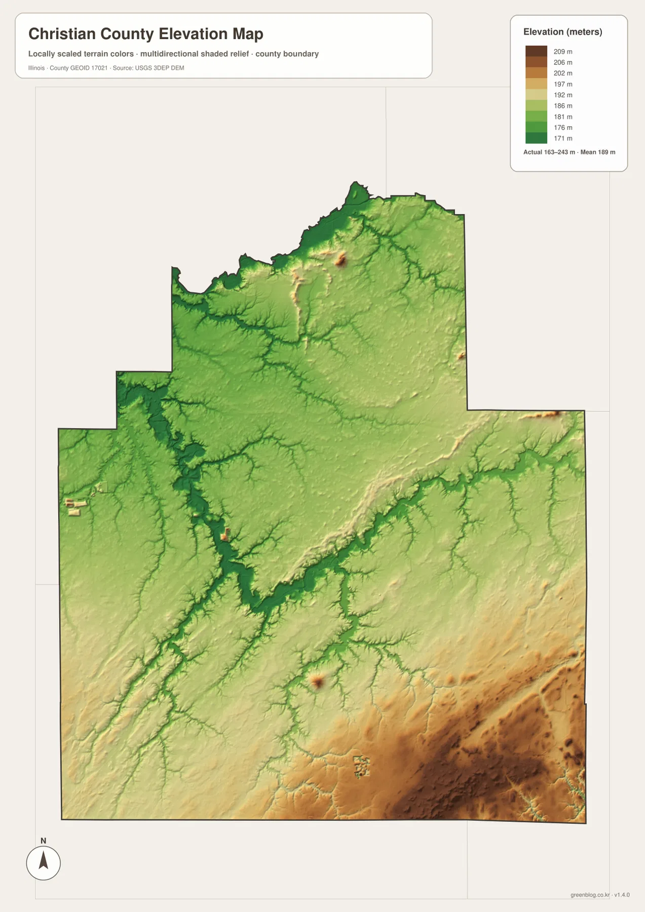
Reading the water and elevation maps together makes the terrain easier to understand. Sangchris Lake, South Fork Sangamon River, and several creek valleys occupy the lower green areas, while the southeastern upland is broader and more continuous. The result is a gentle but real difference in relief across the county. The map is useful for countywide comparison without serving as a survey or engineering surface.
163 to 243 meters is a countywide range
Neither endpoint should be assigned directly to Taylorville, Pana, or another named place. A building lot, road profile, drainage plan, bridge, or parcel needs a point-specific elevation source or a professional survey; the colored surface here is intended only to compare the broad relief of Christian County.
Choosing the Christian County map that fits the question
If the question begins with where Taylorville, Pana, or Assumption sits, start with the detailed county sheet because it keeps roads, streams, and boundaries together. For a cleaner comparison of the six city labels, switch to the simplified city graphic. Questions about Sangchris Lake, South Fork Sangamon River, and the Taylorville-area lakes are easier on the shaded water map, while the elevation colors are most useful for seeing why the west-central drainage corridor sits below the higher southeast.
A practical sequence is to begin at Taylorville on the overview and locate the surrounding towns in each direction. Next, simplify that settlement pattern with the city map. Move to the water map to find Sangchris Lake, South Fork Sangamon River, Buckhart Creek, and Taylorville Lake, then finish with elevation to see how those drainage corridors occupy lower ground below the broader southeastern uplands.
These images work best as a geographic introduction to Christian County, not as operational records. Check current transportation sources before driving, dated Census material for population, flood and lake agencies for water conditions, and point-level elevation or survey data for engineering work. Used within those limits, the set is well suited to printed references, lessons, presentations, and advance orientation around Taylorville and the surrounding towns.
Frequently Asked Questions
What is the county seat of Christian County, Illinois?
The Illinois State Archives lists Taylorville as the Christian County seat from 1839 to the present. Christian County’s official website also describes Taylorville as the major city in the heart of the county. The supplied overview labels the Christian County Courthouse in Taylorville as an additional visual reference.
Does Sangchris Lake extend into Christian County?
Yes. The Illinois Department of Natural Resources says Sangchris Lake extends into both Sangamon and Christian counties. The supplied water map also places the lake along the western county boundary with branches of the water body continuing across that area.
Does 163 to 243 meters give Taylorville’s elevation?
No. The elevation map identifies 163–243 m as the actual range across the Christian County dataset and gives a mean of about 189 m. Exact elevation for Taylorville or any specific road, property, or structure requires point-specific elevation or survey data.
Sources and Reference Material
The explanations above are based on the supplied Christian County maps and the official references listed below. For decisions that depend on current conditions—such as a Taylorville-area road closure, Sangchris Lake rules, a legal boundary, or the elevation of a specific site—consult the responsible agency’s latest source data.
- Christian County Official History Page – Taylorville location and local county context
- Illinois State Archives – Christian County – county establishment, name change, and Taylorville county-seat information
- Illinois DNR – Sangchris Lake State Park – lake location, formation, and recreation information
- USGS National Hydrography – rivers, streams, lakes, and related hydrography data
- USGS 3D Elevation Program – elevation and terrain data
Map File Information
The download bundles the Christian County overview, city comparison, water-and-terrain image, and elevation image as high-resolution JPG files in one ZIP. Each file measures 2,572 × 3,638 pixels, which preserves small town labels, creek names, and elevation colors more clearly when the map is enlarged or printed.
- Included Files: 4 high-resolution JPG maps
- Printable Size: 2,572 × 3,638 pixels each
Related Maps
Green Map creates custom-edited map images using open geographic data sources such as geoBoundaries, Natural Earth, OpenStreetMap, and government open data.
These maps are edited visual materials, not raw data files, and are provided for education, documents, presentations, and graphic reference.