Download the high-resolution Davison County Map JPG files from the ZIP provided on this page. Mitchell is the easiest place to use for orientation: I-90 runs along the southern side of the city, SD 37 continues north-south, and Lake Mitchell sits just to the north. Mount Vernon lies to the west, Ethan is to the southeast, and Loomis appears north of Mitchell. The same map package also follows Firesteel Creek, James River, Dry Run, Enemy Creek, and Twelvemile Creek and shows an elevation range of 367 to 518 meters.
Davison County is easiest to understand by following Mitchell outward. West of the city, the settlement pattern becomes more rural toward Mount Vernon. North and east, Lake Mitchell, Firesteel Creek, and James River create a clear water framework. South and southwest, the terrain gradually rises, with the highest colors concentrated near the southwestern corner. Reading the county this way links roads, settlements, water, and relief without treating the four map views as unrelated inventories.
Table of Contents
Mitchell provides the clearest road reference in Davison County
The general county map places Mitchell near the east-central side of the county. I-90 runs east-west just south of the built-up area, while SD 37 continues north-south through the Mitchell corridor. SD 38 is labeled near the city, and SD 42 crosses the southern part of the county. With these roads identified, it becomes much easier to place the rural western and southern parts of Davison County.
Mount Vernon sits west of Mitchell, while Loomis is labeled north of the city near the rail and road corridor. The James River begins to appear as a winding line near the eastern county edge, adding a natural reference that the straight road grid does not provide. The map is intended for geographic orientation rather than live navigation, so current traffic, road work, closures, and driving time should be checked with a current transportation source.
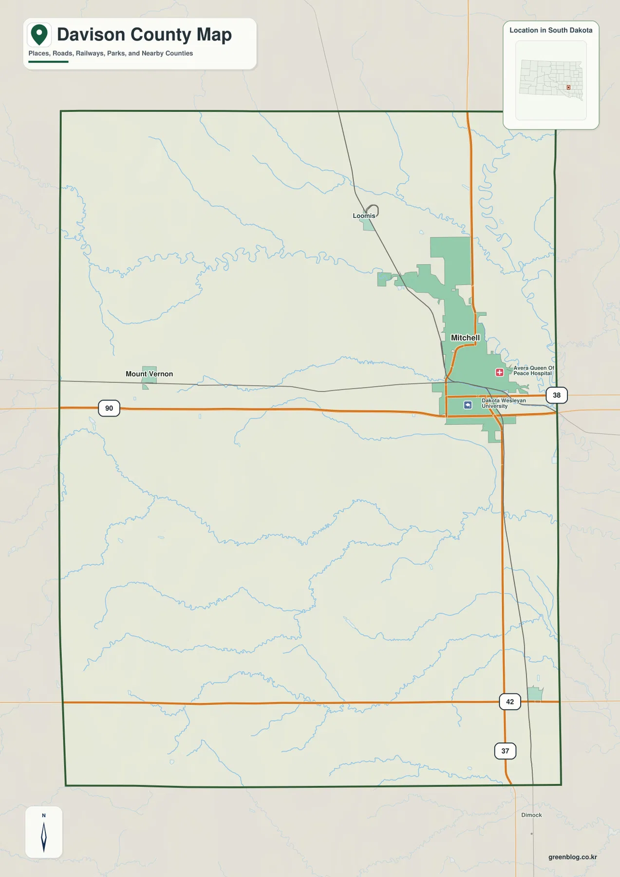
The map also labels Dakota Wesleyan University and Avera Queen of Peace Hospital within Mitchell. Those landmarks reinforce the location of the city’s built-up area, although the purpose of this page is county-scale map reference rather than facility navigation. Davison County’s official website identifies Mitchell as the county seat, which matches its strong visual role as the county’s main settlement and road center.
Mitchell is the hub for the Mount Vernon and Ethan distance diagram
The city-connections view uses Mitchell as the hub. Mount Vernon is placed to the west and labeled about 11 miles away, while Ethan is to the southeast at about 13 miles. These are straight-line distances, not driving distances, so actual road mileage can be longer and will depend on the route used.
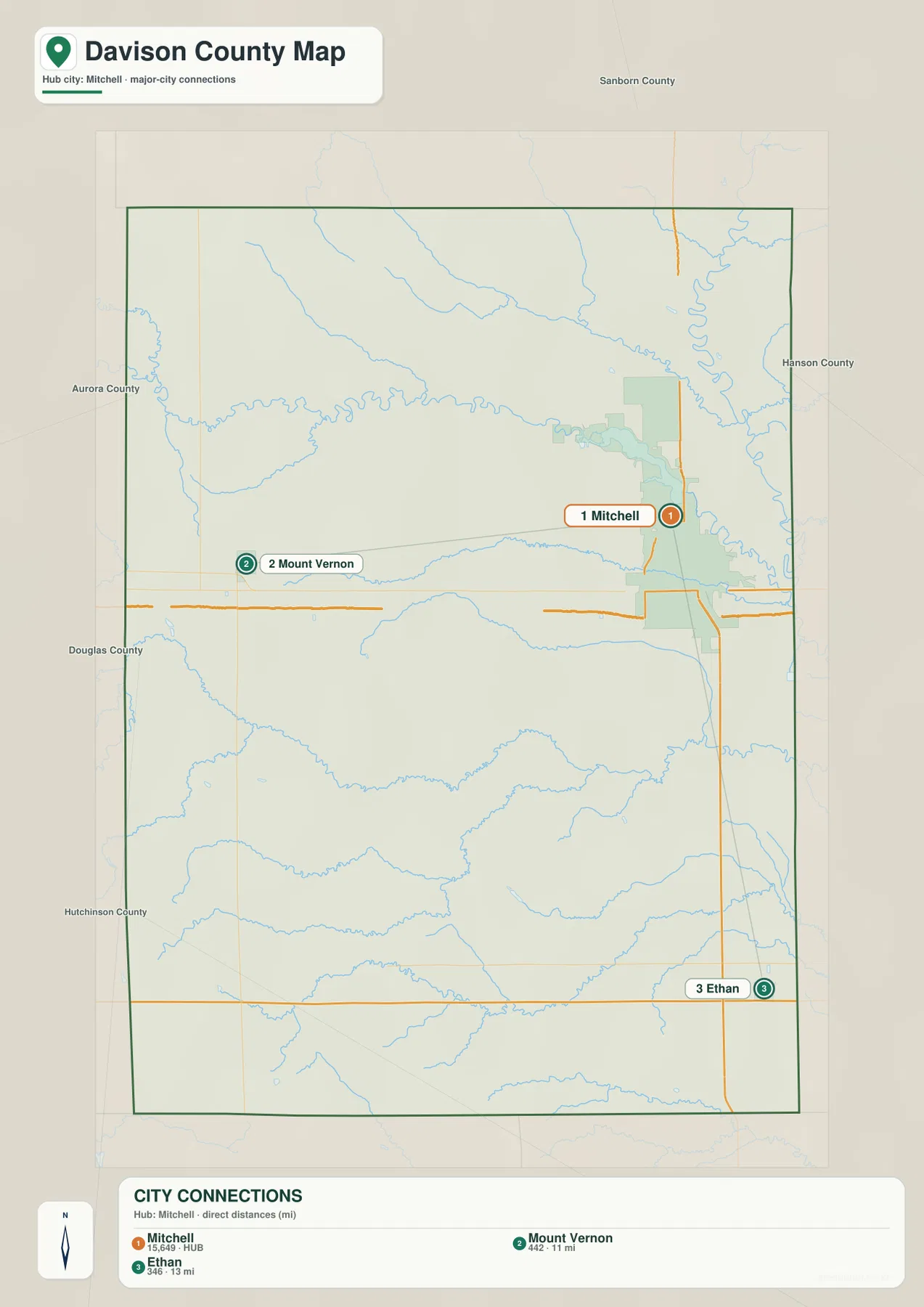
The CITY CONNECTIONS index prints Mitchell 15,649, Mount Vernon 442, and Ethan 346. This article treats those numbers only as values printed on the supplied image, not as current population estimates. Anyone who needs current population should verify it separately with the U.S. Census Bureau.
The simplified connection view does not reproduce every road. For travel planning, return to the general county map and use a current navigation service for driving distance and time. Its main value is quickly showing that Mount Vernon and Ethan lie in different directions from the Mitchell hub.
Lake Mitchell and Firesteel Creek lead toward the James River side of the county
The terrain-and-water view places Lake Mitchell north of the city and Firesteel Creek across the northern part of the county. The creek approaches the lake area from the west and continues toward the eastern drainage network. James River is the strongest river line near the eastern edge, where it bends sharply north and south. Dry Run Creek also approaches the James River from the northwest.
Farther south, Dry Run crosses the middle of the county, Enemy Creek bends through the south-central area, and Twelvemile Creek runs across the lower portion of the map. West Fork Twelvemile Creek joins that southern network. These channels make the interior much more detailed than it appears on the road map, especially away from Mitchell.
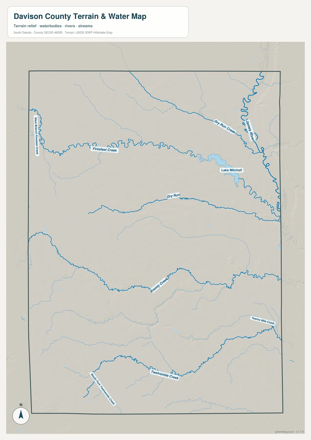
A West Branch Firesteel Creek label is also visible toward the western edge. Together with Firesteel Creek and the James River, it helps explain the northern drainage system. The static map is useful for names and locations, but it does not report current lake level, streamflow, flood risk, water quality, fishing conditions, or boating safety.
For current field conditions around Lake Mitchell, James River, or the smaller creeks, use up-to-date USGS or local information. The purpose of this image is to show where the named water features sit relative to Mitchell, the county boundary, and the roads shown on the other map.
The county rises toward the southwest and drops toward the James River
The elevation view reports an actual range of 367 to 518 meters and a mean of 421 meters. Browns and oranges concentrate in the southwestern corner, marking the highest broad terrain. Moving toward the center, the surface shifts through yellow and light green. The eastern side near James River is much greener, indicating the lowest major corridor on the map.
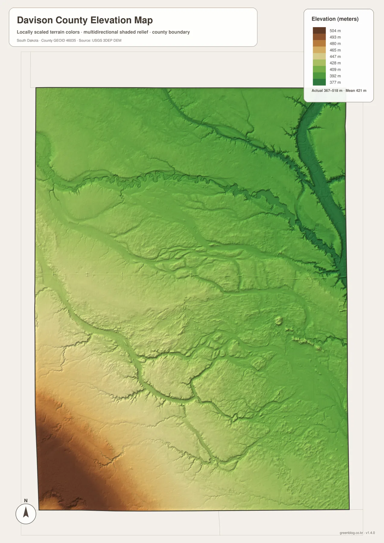
The creek network matches the relief well. Firesteel Creek, Dry Run, and Enemy Creek occupy lower lines through the landscape, while the James River valley forms the clearest low corridor on the east. The county is therefore not simply a flat rectangle: the southwest sits noticeably higher, and several stream valleys cut through the middle before reaching the eastern drainage area.
The 367–518 meter range is appropriate for county-scale comparison, not parcel, building, or engineering measurement. A location-specific elevation should be checked with detailed USGS 3DEP data or professional survey information.
Follow Mitchell across the maps to connect roads, towns, water, and relief
Mitchell works as a useful cross-map anchor. The county map ties it to I-90, SD 37, and SD 38. The city-connections image shows Mount Vernon to the west and Ethan to the southeast. The water view places Lake Mitchell and Firesteel Creek just to the north and James River to the east. The elevation surface then shows Mitchell between the higher southwestern country and the lower river corridor.
Mount Vernon provides a western comparison, while Ethan marks the southeastern side of the county. Around Mount Vernon, settlement and road density are lower than around Mitchell. Toward Ethan, the southern creek network and the SD 42 corridor become more relevant. Following one named place across the maps is a clearer way to understand Davison County than memorizing separate lists of map features.
The ZIP below contains the general county, city, terrain-and-water, and elevation maps as original high-resolution JPG files. Each image is 2572 × 3638 pixels in an A3-friendly format, suitable for printing, classroom handouts, presentations, and close viewing. Legal boundaries, live road conditions, current water information, flood decisions, and survey-grade elevation require current authoritative data in addition to these reference maps.
Frequently Asked Questions
Are the 11 miles to Mount Vernon and 13 miles to Ethan driving distances?
No. The city-connections image labels them as direct distances from Mitchell, so they should be read as straight-line distances. Actual road mileage and travel time depend on the route used.
Can Lake Mitchell and James River be seen on the same water map?
Yes. The terrain-and-water view shows Lake Mitchell and Firesteel Creek in the north and James River along the eastern side. Dry Run Creek, Enemy Creek, Twelvemile Creek, and other channels are also labeled.
Can the 367–518 meter range be used as the exact elevation of a property?
No. The range is useful for broad county-scale comparison. A property-specific or engineering elevation should be checked with detailed USGS 3DEP data or professional survey information.
Map File Information
The Davison County general, city, terrain-and-water, and elevation views are packaged as high-resolution JPG files.
- Included Files: Use only the versions confirmed in the article and supplied images
- File Type: Use the confirmed download contents
- Intended Use: Printing, education, presentations, and map-based projects
Related Maps
Sources and References
The article is based first on the names, roads, water features, and elevation values visible in the supplied Davison County maps. These official sources provide additional county, population, boundary, hydrography, and elevation reference information.
- Davison County official website
- U.S. Census Bureau QuickFacts – Davison County
- U.S. Census Bureau TIGER/Line Shapefiles
- USGS National Hydrography
- USGS 3D Elevation Program
Green Map creates custom-edited map images using open geographic data sources such as geoBoundaries, Natural Earth, OpenStreetMap, and government open data.
These maps are edited visual materials, not raw data files, and are provided for education, documents, presentations, and graphic reference.