Faulkner County sits near the center of Arkansas, with Conway forming the county’s main urban and transportation hub while higher hills rise across the north and northeast. Cadron Creek winds along part of the western side, the Arkansas River bends past the southwest, and Lake Conway occupies a broad area in the south. The maps on this page show these places together with major roads, the distribution of the county’s larger communities, named streams and lakes, and a mapped elevation range of about 75 to 268 meters. High-resolution JPG versions of the same maps are also available in one ZIP download for printing or offline reference.
The county is not a uniform plain. The Encyclopedia of Arkansas describes Faulkner County as a landscape of rolling hills and river valleys, with flatter ground also present in the north. The elevation image makes the contrast easy to see: lower green terrain spreads around Conway, Lake Conway, and the southern part of the county, while tan and brown hills become much more prominent toward the northern and northeastern edges. Looking at the road, water, and elevation maps together helps explain why communities and waterways occupy very different settings within a relatively compact central-Arkansas county.
Table of Contents
Start with Conway to orient yourself in Faulkner County
Conway is the county seat and the strongest reference point on the general map. Faulkner County government offices are based in Conway, and the map shows the city near the southwestern part of the county rather than at its geometric center. Major routes converge here before spreading toward Greenbrier to the north, Vilonia to the east, and Mayflower to the south. That pattern makes Conway the easiest place to begin if you are trying to understand the county’s shape, road system, or the relative position of its smaller communities.
Interstate 40 and U.S. 65 run through the Conway area and continue south toward Mayflower, while U.S. 64 crosses eastward toward the Vilonia side of the county. North of Conway, roads lead through Greenbrier and on toward Twin Groves and Guy. The eastern half includes Enola and Holland, with routes such as 107, 225, 310, 36, and 319 providing additional connections across the county. Rather than treating the map as a list of highway numbers, it is more useful to notice how most routes fan outward from the Conway-Greenbrier corridor and then spread into the hillier east and north.
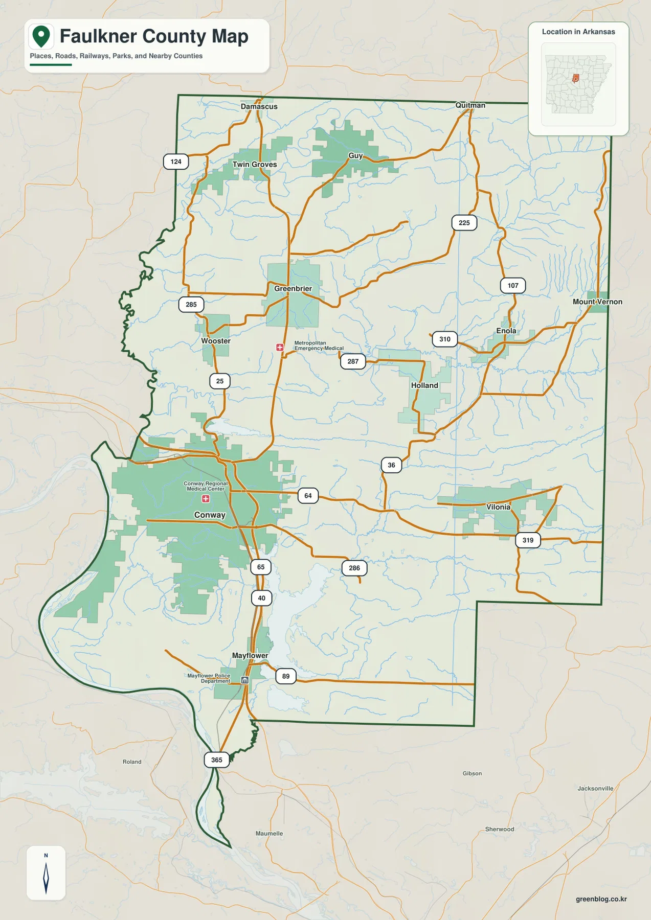
The western edge also gives the county a distinctive outline. Near Cadron Creek and the Arkansas River, the boundary bends and curves instead of following a simple straight line. Much of the eastern and northern boundary is more regular, so the difference is easy to notice on the map. Surrounding labels for Conway, Van Buren, Perry, White, Lonoke, Pulaski, and Cleburne counties help place Faulkner County within central Arkansas and make it easier to understand which nearby towns shown outside the border belong to another county.
Greenbrier, Vilonia, and Mayflower spread in three different directions
The city-distribution map strips away much of the road detail and emphasizes the county’s six ranked major communities. Conway is shown first, followed by Greenbrier, Vilonia, Mayflower, Wooster, and Guy. Their positions reveal a broad pattern: Conway dominates the southwest-central part of the county, Greenbrier anchors the north-central area, Vilonia sits well to the east, and Mayflower lies south of Conway. Wooster and Guy fill in the western and northern parts of the county rather than clustering around the county seat.
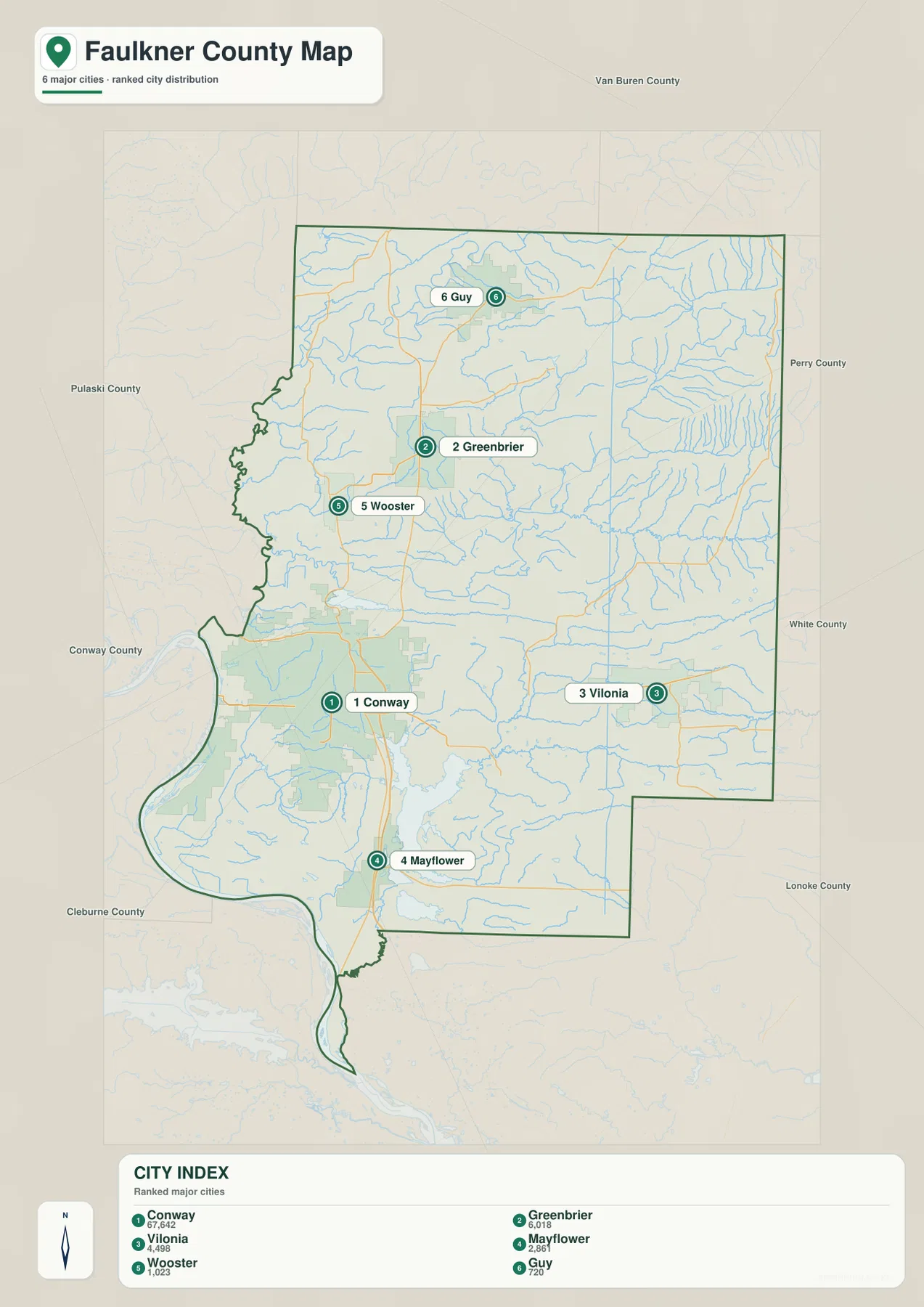
Greenbrier lies north of Conway, with Wooster to its southwest and Guy farther north. Vilonia is separated from the Conway-Greenbrier line by a wide stretch of the eastern county, while Mayflower is positioned along the main north-south transportation corridor near the southern edge. These placements matter when reading the other maps. A location near Guy or the northeastern boundary is generally in higher terrain than a location near Mayflower or Lake Conway, and Vilonia is surrounded by a dense network of smaller streams and ridges that is less obvious on a simple city map.
The numbers on this city map are rankings, not distances from Conway. It does not provide straight-line or driving mileage between the communities. Use it to understand direction and relative distribution, then switch to the general road map when you need to see which routes connect the places. For actual travel distance, road closures, or driving time, a current navigation service or state transportation source is more appropriate.
Cadron Creek and Lake Conway define the western and southern water landscape
Cadron Creek is one of the most important named waterways on the terrain-and-water map. The Encyclopedia of Arkansas notes that Cadron Creek passes through the northwestern corner of Faulkner County and then helps form the boundary between Faulkner and Conway counties before reaching the Arkansas River. That relationship is visible on the map as the creek follows the irregular western side of the county. Farther south, the Arkansas River curves past the county’s southwest side and helps explain the long, narrow extension of the boundary in that area.
Inside the county, the drainage network is dense. East Fork Cadron Creek appears in the north-central area, while Muddy Bayou crosses the east. Clear Creek runs through the central-eastern portion, Palarm Creek extends through the middle and south, and Little Cypress Creek is labeled in the southeast. Numerous smaller tributaries fill the spaces between them. The water map is especially useful here because the shaded terrain underneath the streams shows how many channels occupy valleys between the ridges seen more clearly on the elevation map.
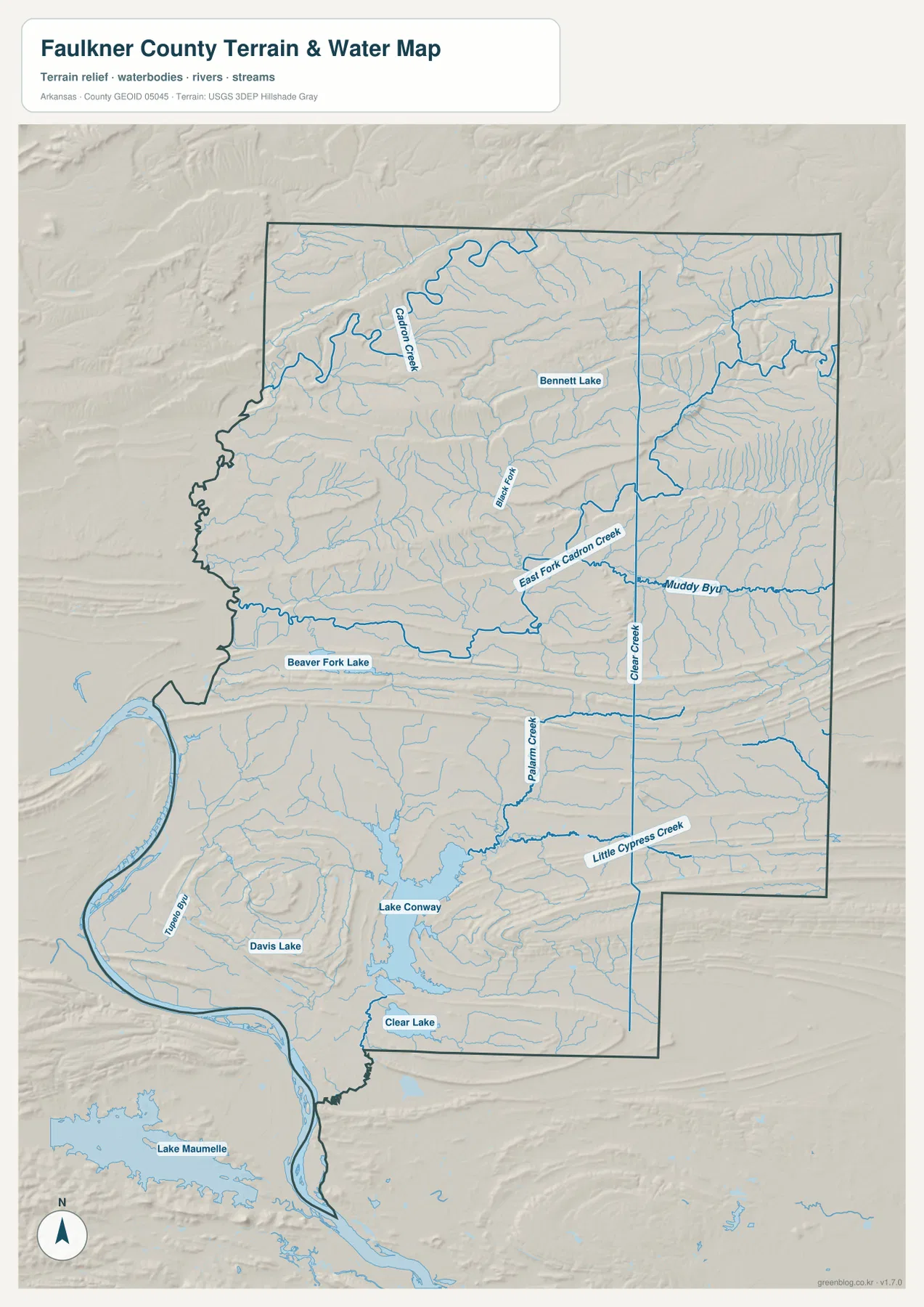
Lake Conway is the largest lake shown within the county and occupies a broad southern area. The Encyclopedia of Arkansas identifies it as a large man-made lake in southern Faulkner County. Beaver Fork Lake is shown north of Conway, Bennett Lake appears farther north, and Davis Lake and Clear Lake are labeled in the southern part of the county. Lake Maumelle is visible outside the county to the southwest, which is helpful for regional context but should not be mistaken for a Faulkner County lake.
This is a reference map for waterbody names, stream locations, and surrounding terrain. It is not a flood-hazard map, navigation chart, water-quality map, or parcel-boundary product. A stream shown near a road or property does not establish legal access, flood risk, or an exact boundary on the ground. Those questions require current information from the appropriate federal, state, or county agency.
Elevation climbs from the Conway–Lake Conway lowlands toward the north
The elevation map gives an actual mapped range of about 75 to 268 meters, with a mean of roughly 123 meters. That is a difference of about 193 meters across the county. The lowest colors cover much of the southern and southwestern ground around Conway, Lake Conway, and the Arkansas River side. Higher colors become more common as the map moves north, and the northeastern quarter contains some of the strongest brown and tan hill relief.
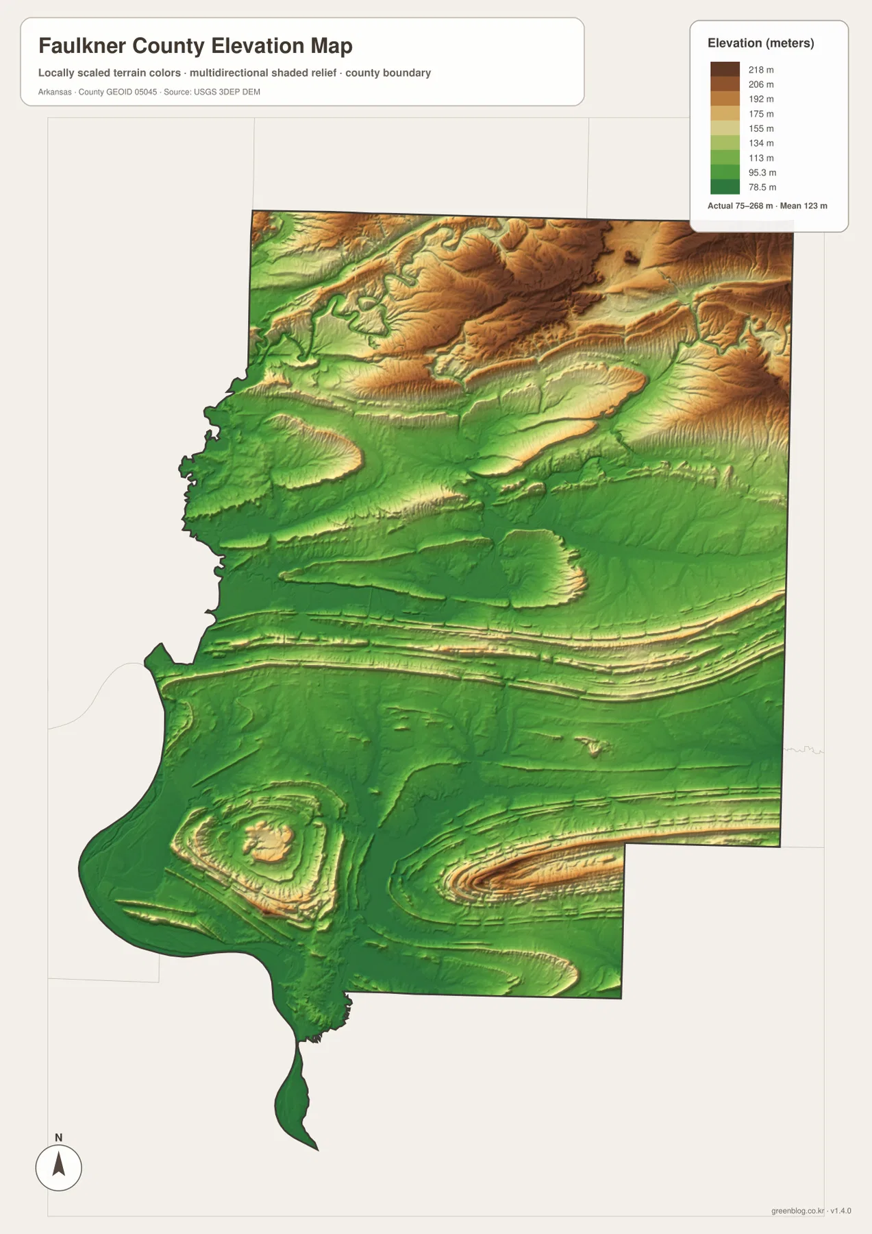
The middle of the county contains several long ridges and valleys that run across the map before the terrain becomes more broken in the north. Around Greenbrier and Guy, higher colors are more frequent than around Conway or Mayflower. The Enola side of eastern Faulkner County also includes pronounced hill relief, while the Lake Conway area is comparatively low and smooth. These differences help explain why the water map shows many short tributaries dropping away from elevated ground before joining larger creeks and bayous.
The shaded elevation surface is intended for county-scale comparison, not survey work. It does not provide the precision needed to establish the elevation of a specific building site, road grade, drainage structure, or property corner. The underlying elevation source is the USGS 3D Elevation Program, and engineering or legal decisions should use the appropriate current, high-precision data. For general geography, however, the map makes the county’s transition from lower southern terrain to northern hills immediately visible.
Match the map to the question instead of reading every layer at once
If your main question is where a town sits, begin with Conway and use the city map to locate Greenbrier, Vilonia, Mayflower, Wooster, or Guy by direction. Then return to the general map to see the roads around that community. This works particularly well for Vilonia, which is easy to place on the city map before tracing U.S. 64 and other roads on the more detailed map. The same approach makes Greenbrier and Guy easier to understand within the northward rise in terrain.
For water features, start with Cadron Creek on the western edge or Lake Conway in the south, then trace smaller names such as East Fork Cadron Creek, Palarm Creek, Clear Creek, Muddy Bayou, and Little Cypress Creek. Comparing the same location on the elevation map shows whether a stream is crossing low ground or cutting between ridges. This is more informative than treating the water and elevation images as separate inventories because Faulkner County’s waterways are closely tied to its changing relief.
The WebP images in the article are reduced for convenient online viewing. The downloadable ZIP contains four high-resolution JPG files at 2572 × 3638 pixels each, matching an A3-style aspect ratio and giving more room to inspect road labels, small waterways, and terrain shading when printed or enlarged. They are useful for education, presentations, personal printing, and general geographic reference. Legal boundaries, surveying, engineering, flood determination, and other high-precision work should still rely on the responsible agency’s official data.
Frequently Asked Questions
Which part of Faulkner County is highest on the elevation map?
The highest terrain is concentrated mainly in the north and northeast, where brown and tan hill relief becomes much more common. The mapped county range is about 75 to 268 meters with a mean near 123 meters. Southern areas around Conway, Mayflower, and Lake Conway are generally lower than the Greenbrier-Guy and northeastern hill areas.
How does Cadron Creek relate to the Faulkner County boundary?
Cadron Creek passes through the northwestern part of the county and helps form part of the boundary between Faulkner and Conway counties as it continues south. That is why sections of the western county line appear curved rather than straight. For an exact legal boundary, use current Census TIGER/Line or county-authorized boundary data rather than a general reference map.
Do the numbers on the city map show distance from Conway?
No. The numbers rank the six major cities shown on this version of the map: Conway, Greenbrier, Vilonia, Mayflower, Wooster, and Guy. The map does not provide straight-line or driving distances. Use it for location and distribution, then consult a current road or navigation source when mileage and travel time matter.
Map File Information
The ZIP contains high-resolution JPG versions of the general county map, ranked city-distribution map, terrain-and-water map, and elevation map. Use the online images to choose what you need, then keep the JPG files for printing or offline reference.
- File Type: ZIP containing 4 JPG files
Related Maps
Sources and references
- Faulkner County Government – official county offices and local government information based in Conway
- Encyclopedia of Arkansas – Faulkner County – county geography, communities, Lake Conway, and historical context
- Encyclopedia of Arkansas – Cadron Creek – Cadron Creek’s course and its relationship to the Faulkner-Conway county line
- U.S. Census Bureau TIGER/Line Shapefiles – county boundaries and transportation features
- USGS National Hydrography – rivers, streams, and waterbody data
- USGS 3D Elevation Program – elevation and terrain data
Green Map creates custom-edited map images using open geographic data sources such as geoBoundaries, Natural Earth, OpenStreetMap, and government open data.
These maps are edited visual materials, not raw data files, and are provided for education, documents, presentations, and graphic reference.