Champaign County in east-central Illinois is easiest to understand by starting with the paired urban area of Champaign and Urbana. Rantoul and Thomasboro lie to the north, Mahomet and Fisher to the west, and St. Joseph and Homer toward the east. Savoy, Tolono, Sadorus, Ivesdale, Philo, and Sidney are spread across the southern half. The road network looks fairly regular, but numerous small streams cross the county, and the elevation map shows more variation than a simple flat-plains image might suggest.
This Champaign County Illinois Map page combines a detailed county overview, a ranked-city distribution map, a terrain-and-water map, and an elevation map. You can download high-resolution JPG versions of all four supplied maps together in one ZIP file for printing, classroom work, presentations, or closer viewing. The maps are designed for county-scale orientation and comparison rather than live traffic, parcel boundaries, flood decisions, navigation, or survey-grade elevation.
Champaign County’s official website says the county was organized in 1833 from part of Vermilion County and identifies Urbana as the county seat. It also notes that Interstates 57, 72, and 74 meet within the county. That transportation importance is easy to recognize on the supplied overview, where the Champaign-Urbana area contains the densest road pattern and routes extend north toward Rantoul and west toward Mahomet.
Table of Contents
Champaign-Urbana forms the central road and city reference
The county overview gives Champaign and Urbana the strongest visual presence. The two cities form one continuous urban area, with Parkland College labeled on the Champaign side. East-west routes cross the urban center from the Mahomet direction toward St. Joseph and Homer, while north-south routes extend from Savoy and Tolono through the central area toward Thomasboro and Rantoul.
Rantoul is the largest labeled urban area in the north, with Route 136 crossing from Fisher through Rantoul and continuing east. Thomasboro lies between Rantoul and the central cities. Mahomet sits to the west where several roads converge before heading toward Champaign. Farther south and east, Philo, Sidney, St. Joseph, and Homer provide useful reference points for the more rural parts of the county.
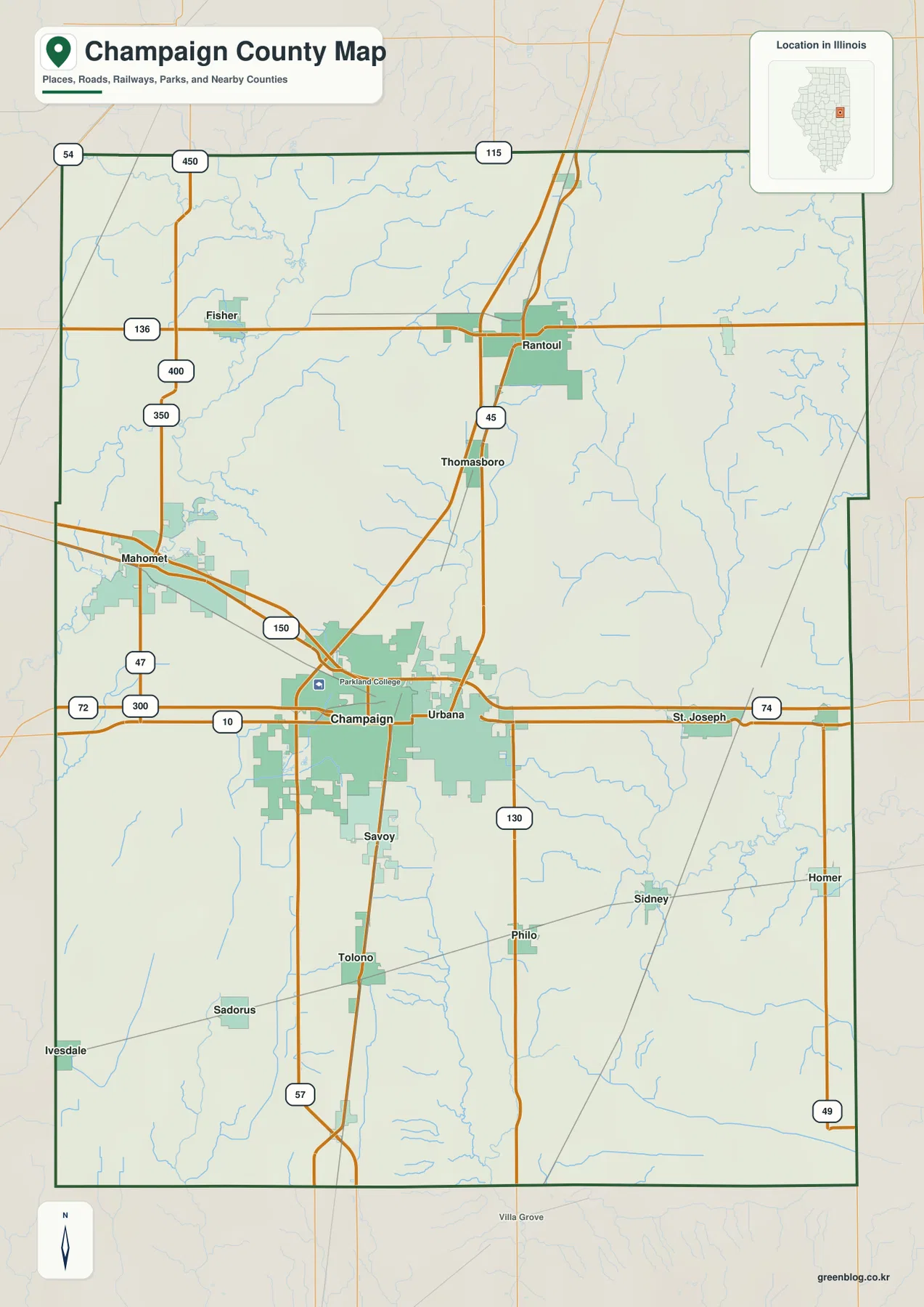
Route numbers provide a useful geographic frame. The map includes 45, 47, 49, 54, 57, 72, 74, 115, 130, 136, 150, 300, 350, 400, and 450, with many routes meeting or passing close to Champaign-Urbana. The overview is useful for orientation, but it is not a live traffic product. Current construction, closures, lane details, and exact access points require current transportation information.
Urbana is the county seat inside a larger twin-city area
Champaign and Urbana appear as one broad central urban zone on the map, but their administrative roles are not identical. Champaign County’s official website identifies Urbana as the county seat. For geographic orientation, it is practical to treat Champaign-Urbana as one central reference area while keeping Urbana’s county-seat role distinct.
Six ranked places show the central city pair and outer anchors
The city-distribution map removes most road detail and highlights six places. Champaign is ranked number 1, Urbana number 2, Rantoul number 3, Mahomet number 4, Savoy number 5, and St. Joseph number 6. The printed CITY INDEX lists values of 89,996 for Champaign, 39,341 for Urbana, 12,421 for Rantoul, 10,419 for Mahomet, 8,968 for Savoy, and 3,778 for St. Joseph.
The graphic does not display a census year or statistical date beside those values, so this article does not present them as current population counts. They are treated only as figures printed on the supplied city map. The spatial pattern is clear without making a population claim: Champaign and Urbana form the central pair, Savoy sits immediately south, Rantoul is north, Mahomet west, and St. Joseph east.
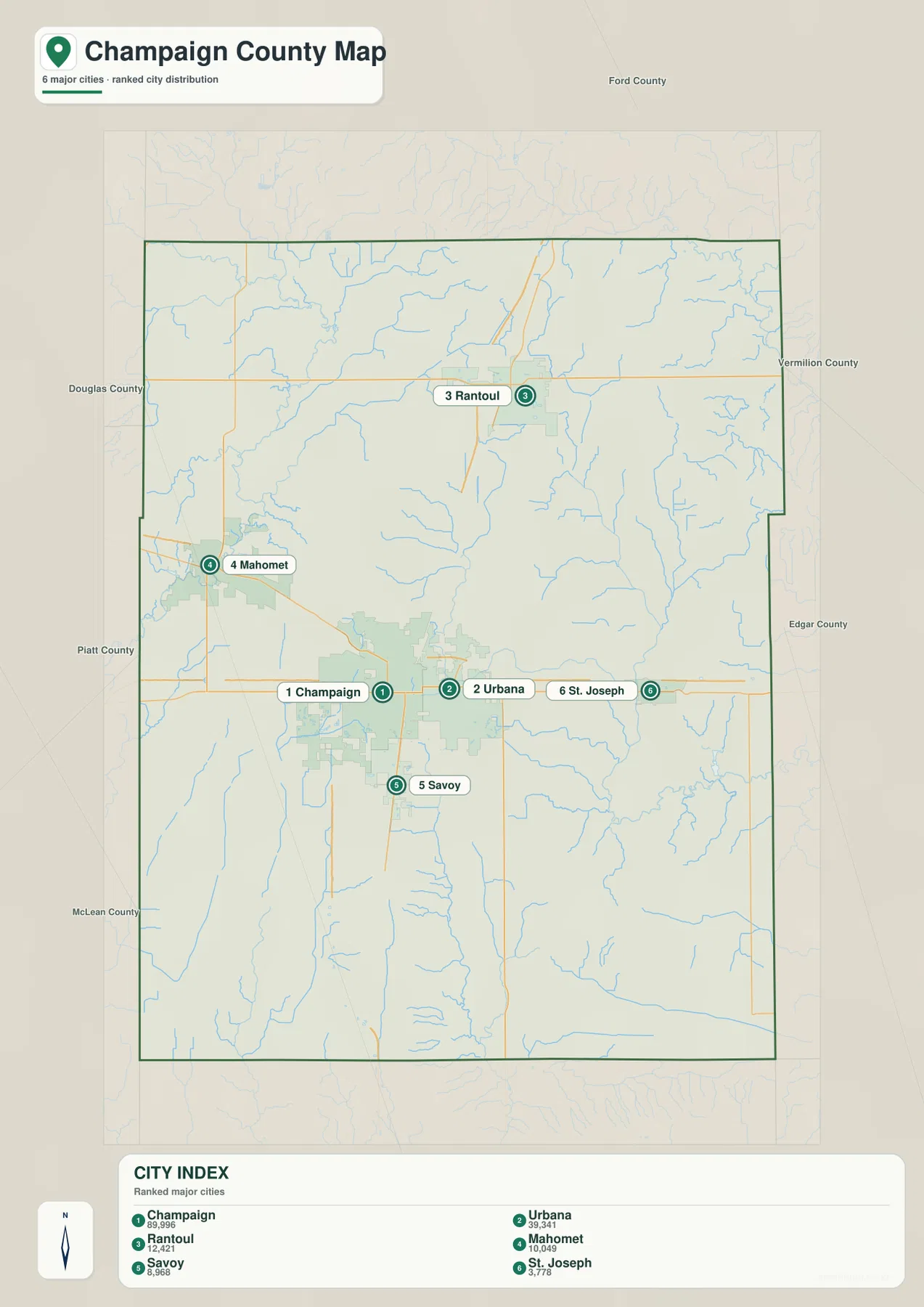
The simplified map also helps place the county within its neighbors. Ford County is to the north, Vermilion County to the east, Douglas and Piatt counties to the southwest and west, and McLean County toward the southwest edge. Within that frame, Rantoul and Mahomet sit on different axes from the central cities, while St. Joseph is close to the eastern side.
The CITY INDEX is map data, not a current census table
If a report requires current official population figures, use a dated U.S. Census Bureau source. The supplied graphic does not identify the year behind its index. On this page, the values are used only to describe the supplied ranking and the relative prominence and location of the six labeled communities.
Sangamon and Embarras watersheds divide the county
The terrain-and-water map shows that Champaign County is drained in several directions. The Sangamon River is labeled in the northwest, with Lake Greenwood nearby. Lake of the Woods and Spring Lake provide additional western water landmarks around the Mahomet side of the county. South of the Champaign-Urbana area, Clear Lake, Maynard Lake, and Lincolnshire Lake appear close together as smaller named water bodies.
The southern half is dominated by a different drainage pattern. Embarras River runs south through the county, and East Branch Embarras River crosses the southeastern side. Spoon River forms a long north-south feature in the eastern half, while Little Vermilion River appears in the lower east. Homer Lake is the large named lake on the eastern side. Rather than one dominant river, the county contains several headwater and upper-river systems flowing toward different basins.
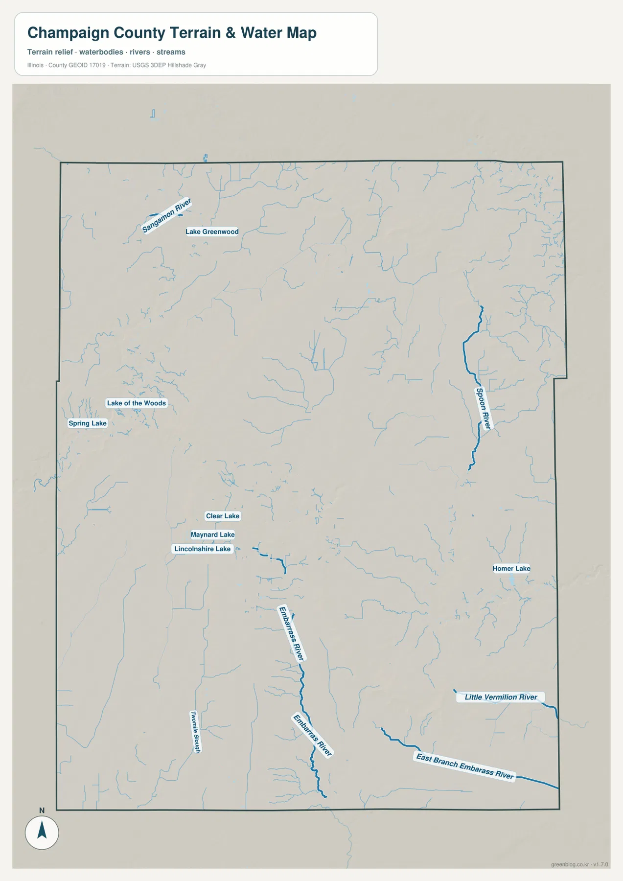
Champaign County Forest Preserve District materials give local context to those blue features. Lake of the Woods Forest Preserve occupies land along the Sangamon River corridor in Mahomet, while Homer Lake Forest Preserve includes an approximately 81-acre lake on the eastern side of the county. District planning documents also describe multiple forest preserves located along county waterways, reinforcing how closely the local preserve system follows the river network shown on the map.
The water map is not a flood, depth, or navigation product
The map shows the locations of rivers, streams, lakes, and surrounding terrain. It does not provide flood-hazard zones, live water levels, water depth, navigable routes, boating conditions, water rights, or legal access. Current USGS, Champaign County Forest Preserve District, and other responsible agency information should be used for safety, flood, or regulatory decisions.
Higher northern and western ground falls toward eastern lowlands
The elevation map reveals more relief than the regular road grid suggests. Brown high ground forms a broad belt across the north-central part of the county, and another elevated ridge appears in the west and southwest. Much of the east-central and southeastern county is green, indicating lower terrain, with darker narrow corridors marking stream valleys. The result is a gentle but clearly structured landscape rather than a perfectly level plain.
The map reports an actual countywide elevation range of about 190 to 261 meters and a mean of about 216 meters. Its color legend uses bands from roughly 201 to 239 meters, while the separate “Actual” line records the wider minimum and maximum in the underlying county dataset. Those endpoints describe Champaign County as a whole; they are not exact elevations for Urbana, Rantoul, Mahomet, or any specific property.
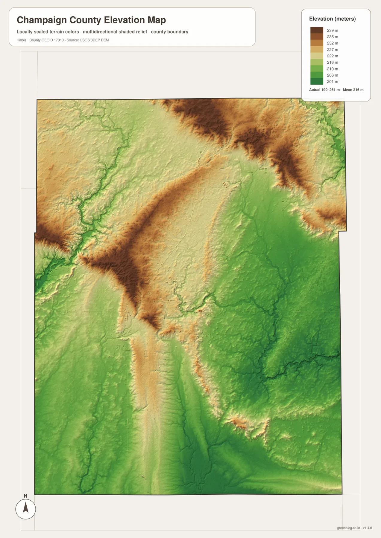
Comparing the water and elevation maps makes the drainage pattern easier to understand. Spoon River and the Embarras system occupy lower green areas in the east and southeast, while the Sangamon corridor near Mahomet also follows a local low zone. Smaller tributaries cut narrow channels through the higher northern and western ground. The maps are useful for broad geographic comparison without turning the color surface into a survey or engineering model.
190 to 261 meters is a countywide range
Do not assign the low or high endpoint directly to a named town. Exact elevation for a building site, road grade, drainage design, bridge, or parcel requires location-specific source data or a professional survey. This map is designed for broad county comparison rather than precise engineering measurement.
Choosing the Champaign County map that fits the question
Use the county overview when you need Champaign-Urbana, Rantoul, Mahomet, St. Joseph, major roads, boundaries, and streams in one image. The ranked-city map is better for quickly comparing the six labeled communities. Choose the terrain-and-water map for the Sangamon, Spoon, and Embarras river systems and the named lakes. The elevation map is the clearest option for comparing higher northern and western ground with the lower eastern and southeastern drainage country.
A practical sequence is to begin with Champaign-Urbana on the overview, then locate Rantoul to the north and Mahomet to the west. Next, simplify the settlement pattern with the city map. Move to the water map to find Sangamon River, Spoon River, Embarras River, Lake of the Woods, and Homer Lake, then finish with elevation to see how those drainage corridors occupy lower ground below the county’s broad higher ridges.
Each map has a defined purpose. The overview is not a live-traffic or parcel product, the CITY INDEX is not presented as a current census table, the water map does not assess flood or navigation conditions, and the elevation surface is not survey-grade. Within those limits, the set works well for printed reference sheets, teaching, presentations, county orientation, and trip-planning context.
Frequently Asked Questions
What is the county seat of Champaign County, Illinois?
Champaign County’s official website identifies Urbana as the county seat. Champaign and Urbana appear as one broad central urban area on the maps, but Urbana is the administrative county seat. Using the twin-city area as the main geographic reference makes the surrounding towns easy to locate.
Are the CITY INDEX values current population counts?
This page does not treat them as current population figures because the supplied city map does not show a census year or statistical date beside the index. Use a dated U.S. Census Bureau source when an official current population figure is required.
Does 190 to 261 meters give Urbana’s elevation?
No. The elevation map identifies 190–261 m as the actual range across the Champaign County dataset and gives a mean of about 216 m. Exact elevation for Urbana or any specific road, property, or structure requires point-specific elevation or survey data.
Sources and Reference Material
The article uses the supplied Champaign County maps together with the official references below. For current road conditions, water information, legal boundaries, or exact point elevations, use the responsible agency’s current source data rather than these explanatory county maps.
- Champaign County Official Website – county history, Urbana county-seat information, and transportation context
- Champaign County Forest Preserve District – Lake of the Woods – Sangamon River corridor and Lake of the Woods reference in Mahomet
- Champaign County Forest Preserve District – Homer Lake – Homer Lake and local natural-area reference
- USGS National Hydrography – rivers, streams, lakes, and related hydrography data
- USGS 3D Elevation Program – elevation and terrain data
Map File Information
The high-resolution JPG originals for the Champaign County overview, ranked-city map, terrain-and-water map, and elevation map are bundled in one ZIP file. Each image is 2,572 × 3,638 pixels, giving you more detail for zooming, printed reference sheets, classroom materials, and presentation graphics.
- Included Files: 4 high-resolution JPG maps
- Printable Size: 2,572 × 3,638 pixels each
Related Maps
Green Map creates custom-edited map images using open geographic data sources such as geoBoundaries, Natural Earth, OpenStreetMap, and government open data.
These maps are edited visual materials, not raw data files, and are provided for education, documents, presentations, and graphic reference.