Lawrence County sits along Tennessee’s southern border with Alabama, and its long north-to-south shape makes the map easiest to understand through a few strong geographic relationships. Lawrenceburg occupies the central part of the county and serves as the county seat, while Ethridge and Summertown lie to the north and Leoma, Loretto, St. Joseph, Iron City, and Westpoint extend the settlement pattern toward the Alabama line. The supplied maps also show two different water settings: the Buffalo River headwaters and tributaries across the northern hills, and Shoal Creek running from the Lawrenceburg area toward the southwest.
This page includes a general county map, a simplified city-connection map, a water map, and an elevation map. The images can be used as on-page references, and the map file box later on the page provides a ZIP containing four high-resolution A3 JPG files for printing or reuse. Looking at the maps together is especially helpful in Lawrence County because the main town corridor, drainage network, and elevation pattern reinforce one another rather than appearing as unrelated layers.
Table of Contents
A long southern Tennessee county anchored by Lawrenceburg
The Alabama state line forms the county’s southern edge, with Lauderdale County, Alabama directly across that boundary. Wayne County lies to the west, Lewis County to the north, Maury County to the northeast, and Giles County to the east. The outline is tall and somewhat irregular, so the surrounding county names are useful orientation points when a road or stream approaches the edge of the map.
Lawrenceburg stands out as the central road and settlement hub. US 43 runs north and south through the county, passing the Ethridge–Lawrenceburg corridor before continuing toward Leoma, Loretto, and St. Joseph. US 64 approaches Lawrenceburg from the west, while several state routes branch toward Summertown, Westpoint, Iron City, and the eastern county line. The general map labels routes including SR 20, SR 15, SR 98, SR 227, SR 240, SR 241, SR 242, SR 355, SR 357, SR 361, SR 365, and SR 367, giving enough detail to see how the smaller communities connect without turning the page into a street map.
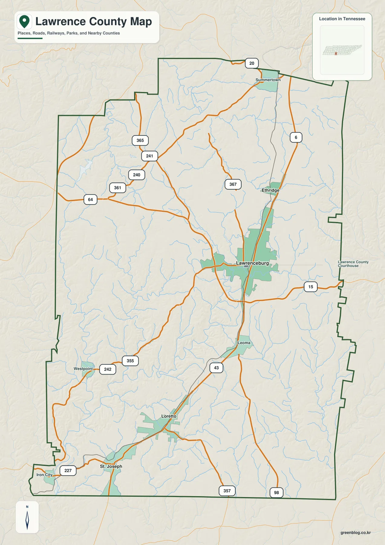
The 2020 census counted 44,159 residents in Lawrence County, and the Census Bureau’s July 2025 estimate is 46,914. QuickFacts reports 617.13 square miles of land and a 2020 density of 71.6 people per square mile. Those countywide numbers are useful for scale, but the map adds the missing geographic detail: the built area around Lawrenceburg is much more prominent than most other settlements, and smaller towns are spread along distinct road corridors rather than evenly across the county.
US 43 links the main town chain from Ethridge to St. Joseph
The city map strips away much of the secondary road detail and makes one pattern very clear. Lawrenceburg is the hub, Ethridge is close to the north, and Loretto and St. Joseph form the main southern references. The map’s direct-distance labels place Ethridge about 5 miles from Lawrenceburg, Loretto about 13 miles away, and St. Joseph about 18 miles away. These are useful map distances rather than turn-by-turn driving measurements, but they give a quick sense of the county’s elongated settlement pattern.
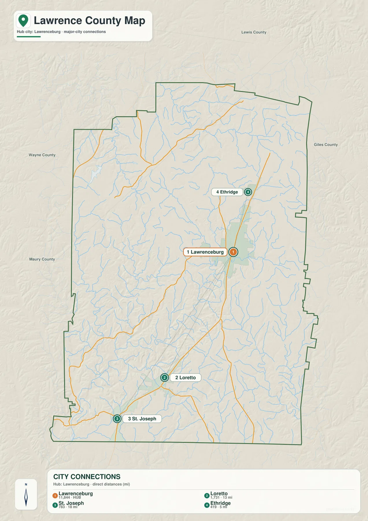
US 43 explains much of this arrangement. It passes through or near the central string of communities, so Lawrenceburg, Leoma, Loretto, and St. Joseph read as a north-south sequence rather than isolated labels. The general map adds other useful reference points that the simplified city image leaves out. Summertown occupies the northern part of the county near the Lewis County side, while Iron City and Westpoint sit farther southwest near the Shoal Creek valley.
This distinction matters when using the map for regional comparison. A route from Lawrenceburg toward Loretto follows the central-southern corridor, while a trip toward Iron City moves into a different part of the county with a stronger connection to Shoal Creek and the southwestern lowlands. Toward Summertown, the setting changes again as the road network reaches the dissected northern hills and the Buffalo River drainage.
Buffalo River headwaters in the north, Shoal Creek toward the southwest
The water map gives Lawrence County a much clearer internal structure than the road map alone. Across the north, the Buffalo River system appears as several named branches, including the Buffalo River, West Fork Buffalo River, South Fork Buffalo River, and Little Buffalo River. Tennessee’s environmental agency identifies the Buffalo as a major unimpounded river of Middle Tennessee and lists Lawrence County among the counties it crosses. On this county-scale map, its upper tributaries occupy the deeply cut northern landscape.
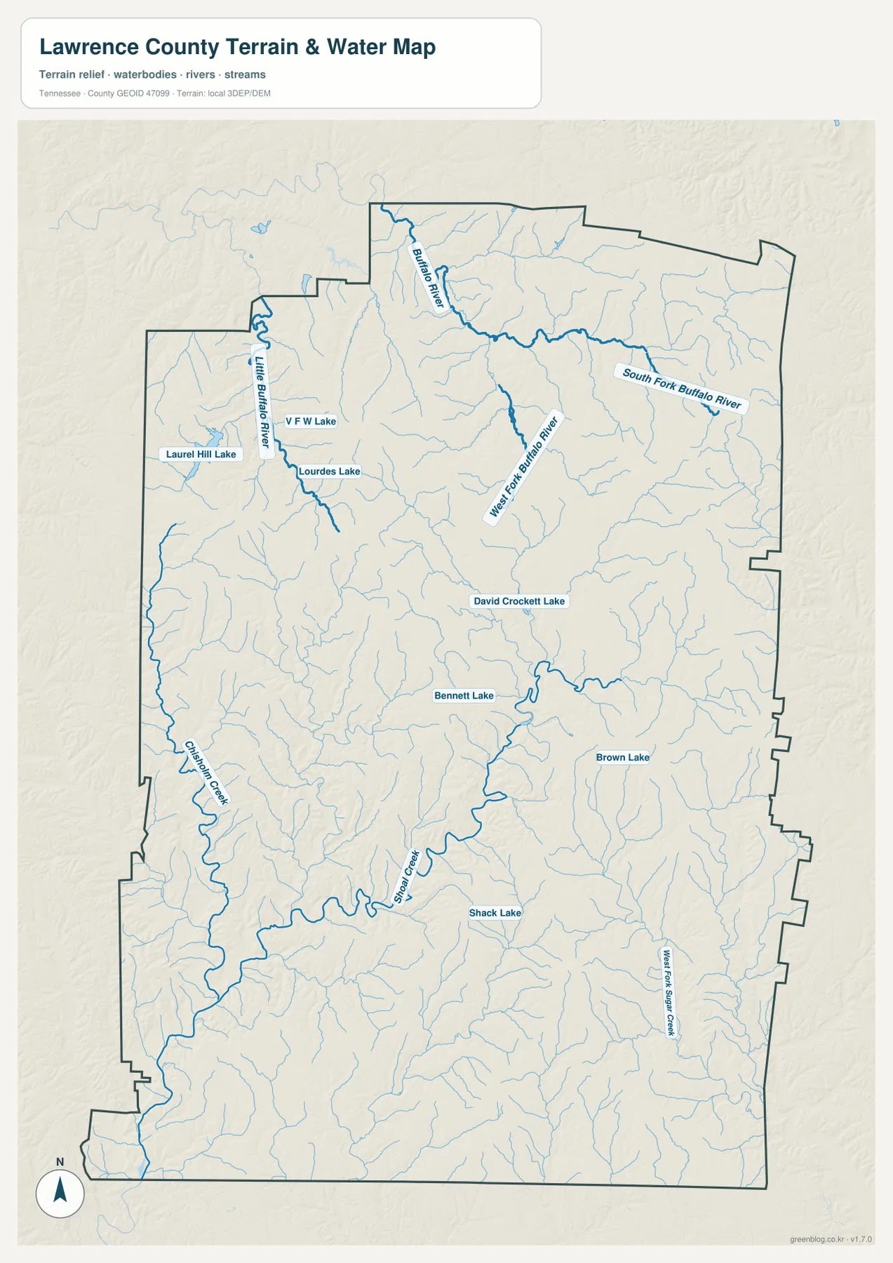
Shoal Creek provides the other strong water reference. USGS has long maintained stream records in the Lawrenceburg area, and the map shows Shoal Creek bending from the central county toward the southwest. That course is easy to match with Westpoint and Iron City on the general map. It also helps explain why the southwestern corner looks different on the elevation image: a broad low corridor follows the drainage while higher ground rises to either side.
Several smaller water bodies add local landmarks. David Crockett Lake lies west of Lawrenceburg, while Laurel Hill Lake, Lourdes Lake, and V F W Lake appear in the northwest. Bennett Lake, Brown Lake, and Shack Lake are labeled farther south. These lakes are not the dominant geographic feature of the county, but they are useful checkpoints when comparing the water image with the road and elevation maps because they help locate specific sections of otherwise rural terrain.
Elevation falls from the northern hills into the southwestern valleys
The elevation map uses a local scale that ranges from about 162 to 332 meters, with a mean elevation of roughly 268 meters. The highest colors are concentrated across much of the northern and northeastern part of the county, where closely spaced ridges and valleys create a rough texture. In contrast, the southwest contains a broad green lowland associated with the Shoal Creek drainage, with additional narrow green valleys extending through the central and southern landscape.
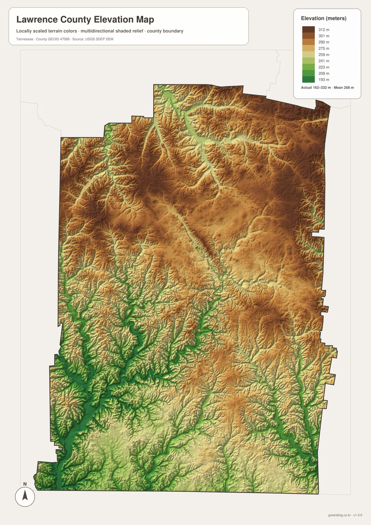
The dense branching pattern on the water map makes more sense beside this image. Northern tributaries occupy narrow valleys cut into higher terrain, producing many short branches before they join the larger Buffalo River system. South and southwest of Lawrenceburg, the lower terrain follows Shoal Creek and its tributaries more clearly. The maps therefore show not just where the streams are, but why some parts of the county have a much more dissected appearance than others.
Elevation colors should not be read as land ownership or land-cover categories. A high brown area may contain forest, farms, roads, or homes, and a low green valley does not automatically mean wetland or floodplain. The layer is most useful for comparing relative height and landform shape. Anyone who needs parcel-level elevation, engineering grades, or current flood information should use the appropriate detailed source rather than treating this county illustration as a survey.
What each map adds when the same place is compared
A useful way to work with these files is to follow one location through all four views. Start with Lawrenceburg on the general map, where US 43, US 64, city boundaries, and nearby streams can be seen together. The city map then removes most secondary detail and emphasizes Lawrenceburg’s relationship to Ethridge, Loretto, and St. Joseph. Switching to the water map places the city beside Shoal Creek and David Crockett Lake, while the elevation map shows that Lawrenceburg sits between the more rugged northern uplands and the lower southwestern drainage corridor.
The same approach works for the county edges. Near Summertown, the general map shows the northern road approach, the water image shows branches of the Buffalo River system, and the elevation layer reveals heavily incised higher ground. Around Iron City and Westpoint, Shoal Creek becomes the dominant natural reference and the elevation colors drop into a much lower valley. Loretto and St. Joseph, meanwhile, are easiest to follow on the city and county maps because their relationship to US 43 and the Alabama border is more important than any single large water body.
For printed notes, choose the map that matches the question rather than crowding every subject onto one sheet. The county map works well for roads and boundary comparisons, the city map for settlement spacing, the water map for river and lake names, and the elevation image for hills and valleys. Printing more than one file side by side is often clearer when a lesson or local research project needs to explain why roads, towns, and streams occupy different parts of Lawrence County.
Frequently Asked Questions
Which map is best for comparing Lawrenceburg, Loretto, and St. Joseph?
The city map is the quickest view because it reduces the road detail and emphasizes the relative position of the main towns. Use the general county map beside it when you also want to follow US 43, see Leoma between Lawrenceburg and Loretto, or compare those communities with the Alabama state line.
Why do the Buffalo River and Shoal Creek stand out in different parts of the county?
The Buffalo River system is concentrated in the more rugged northern part of Lawrence County, where several forks and tributaries cut through higher terrain. Shoal Creek passes the Lawrenceburg area and continues toward the lower southwest. Comparing the water and elevation maps makes this north-versus-southwest difference easier to see.
What is included in the downloadable Lawrence County map ZIP?
The archive contains four high-resolution A3 JPG files: the general county map, city-connection map, water map, and elevation map. The WebP images in the article are convenient previews, while the JPG files are the better choice for printing or placement in a larger document.
Map File Information
The ZIP contains the Lawrence County general map, city map, water map, and elevation map as high-resolution A3 JPG files. Use the larger originals when you need a print copy or a map that can be placed into another document.
- Included Files: Four high-resolution A3 JPG maps
Related Maps
Sources and references
- U.S. Census Bureau QuickFacts – Lawrence County, Tennessee
- Tennessee Department of Transportation – Lawrence County functional classification map
- Tennessee Department of Environment and Conservation – Buffalo River
- USGS National Hydrography
- USGS 3D Elevation Program
Green Map creates custom-edited map images using open geographic data sources such as geoBoundaries, Natural Earth, OpenStreetMap, and government open data. These maps are edited visual materials, not raw data files, and are provided for education, documents, presentations, and graphic reference.