An Osceola County Florida Map quickly shows why this county feels different from many of Florida’s more compact urban counties. Kissimmee and St. Cloud sit close together in the northwest, while the county stretches far south through a much broader landscape of lakes, wetlands, creeks, and long road corridors. This page uses a county map, a ranked city map, and a water map to explain where Kissimmee, St. Cloud, Celebration, Poinciana, and Yeehaw Junction sit and how the northern developed area changes toward the south. A ZIP containing three high-resolution A3 JPG maps is available in the download box below.
The county is easiest to understand by separating its northwest corner from the large southern interior. Orange County lies to the north, Polk County to the west, and Brevard and Indian River counties along the east side. The northwest contains the best-known population centers and the densest road network, while the central and southern sections show far more open land and water features. That contrast becomes even clearer when the city and water maps are viewed beside the general county map rather than on their own.
Table of Contents
Kissimmee and St. Cloud anchor the northwest corner
Kissimmee is the strongest reference point on the county map. It sits near the northwest boundary and close to the Orlando side of the region, with St. Cloud immediately to the southeast. Buena Ventura Lakes appears just north and east of Kissimmee, while Campbell is shown to the southwest. Celebration and Four Corners lie farther west, and Poinciana appears south of Kissimmee. These place names make the northwest corner look relatively busy compared with the long southern part of the county.
The major roads reinforce that pattern. State Road 417 approaches the northwest side near Celebration and Kissimmee, while US 192 runs east from Kissimmee through the St. Cloud area. Other numbered routes shown around St. Cloud and the central corridor include 91 and 500. Even without a dense street-level road network, these larger highways make it easy to see how the main population centers relate to one another and to the Orange County side of the metropolitan area.
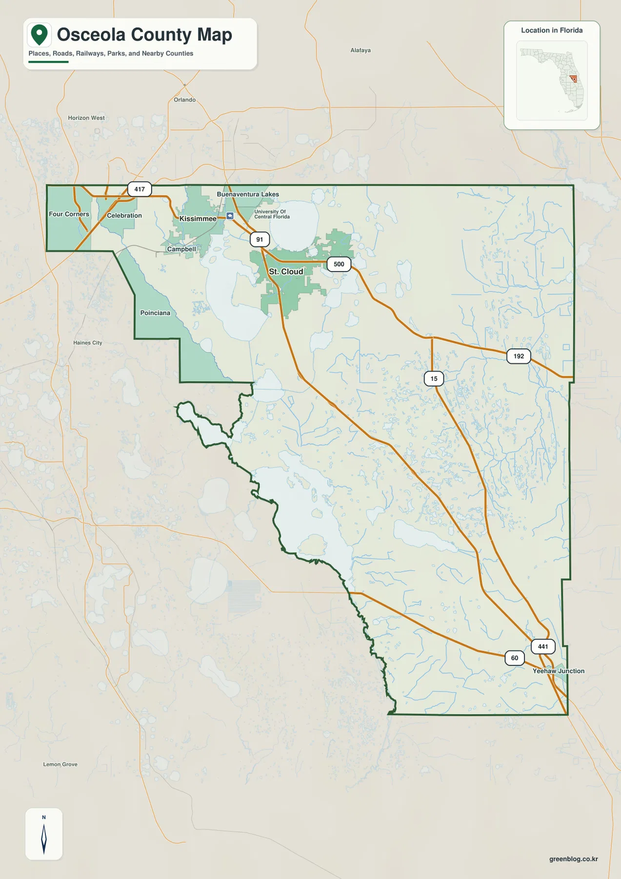
The county boundary itself is worth noticing. The north edge is comparatively broad and regular, but the southwest side steps inward and then follows a much more irregular line through lake and wetland country. The county becomes long and narrow toward the south before reaching the Yeehaw Junction area. Looking at the outline together with nearby county names helps explain why places in western Osceola can feel closer to Polk County while eastern locations are oriented toward Brevard and Indian River counties.
The ranked city map concentrates on two incorporated cities
The city map ranks Kissimmee first and St. Cloud second. Both markers sit in the northwest part of Osceola County, which makes the concentration of the county’s incorporated urban population immediately obvious. Kissimmee is positioned farther west and slightly north, while St. Cloud lies southeast of it. The rest of the county extends a long distance beyond those two markers, especially to the south and southeast.
This map is intentionally different from the general place map. Well-known names such as Celebration, Poinciana, and other communities can appear on the county map without being listed as ranked incorporated cities on the city map. That distinction is useful because it prevents the reader from assuming that every familiar place name has the same municipal status. For broad orientation, the county map is better; for comparing the two major incorporated cities, the city map is cleaner and easier to read.
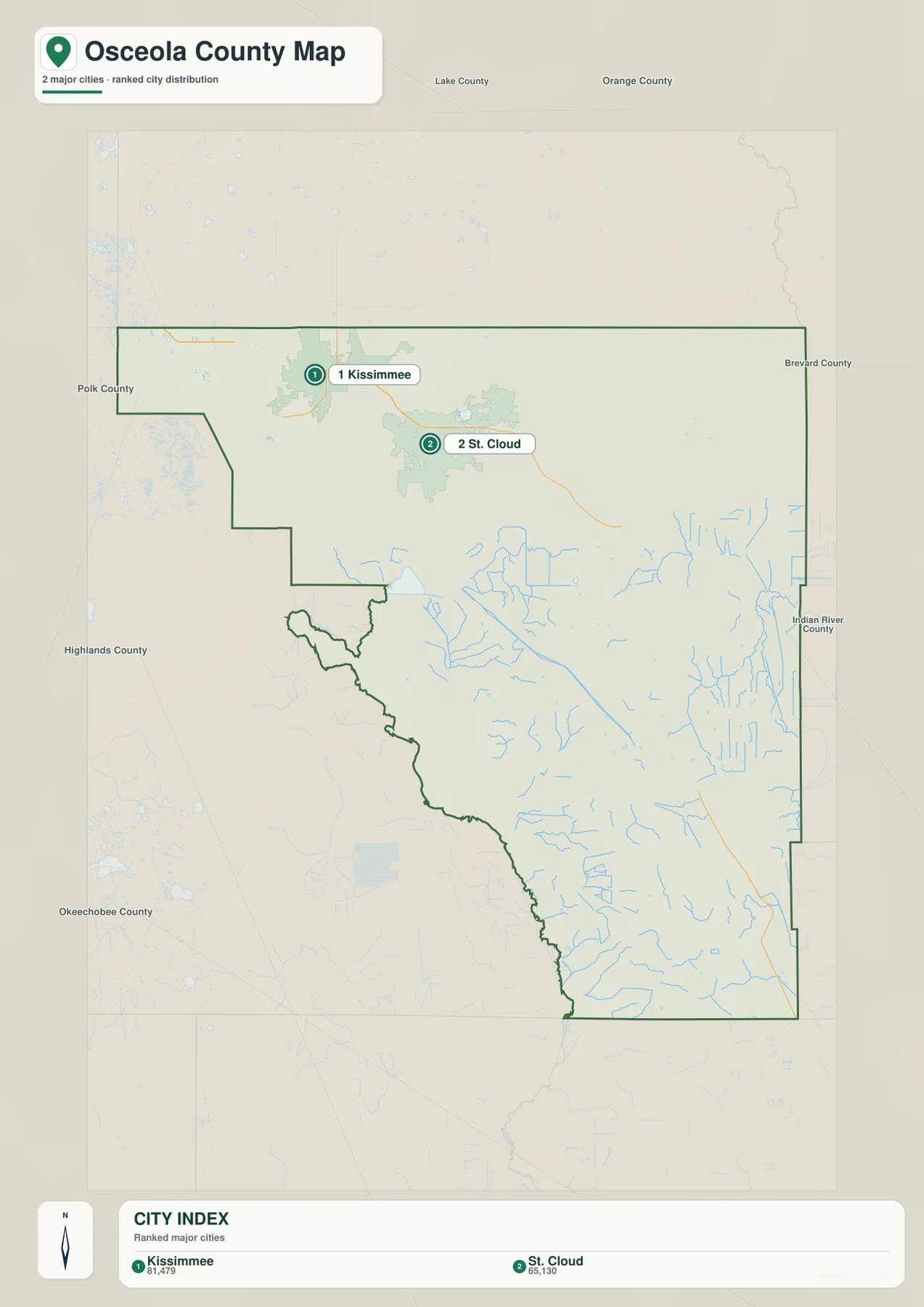
The surrounding county labels also add context. Orange County is immediately north of the city cluster, Polk County is west, and Brevard County is east. This helps explain why the northwest section feels connected to the broader Central Florida urban area even though Osceola County itself continues far beyond the built-up zone shown around Kissimmee and St. Cloud.
From US 192 to Yeehaw Junction: reading the long southbound routes
US 192 is the easiest east-west reference across northern Osceola County. It links the Kissimmee–St. Cloud area with the eastern side of the county and remains a useful line for locating communities and water features north of the more rural interior. South of St. Cloud, State Road 15 and US 441 form important north-south routes. Near the southern end of the county, US 441 meets State Road 60 at Yeehaw Junction, giving the map a clear road reference at the far end of the long county shape.
The farther south the map goes, the fewer large settled places appear along these roads. Instead, small lakes, wet areas, and branching creeks become more common. The road lines stretch through broad open areas rather than through a continuous chain of towns. For a reader planning a regional drive or simply trying to understand distance, this is an important visual clue: the northern city cluster occupies only a small part of the county’s total north-to-south extent.
Creeks, lakes, and wetlands shape much of the interior
The water map makes Osceola County’s inland water network much easier to see. Shingle Creek and Reedy Creek are labeled in the northwest, near the part of the county closest to Kissimmee and the Orlando-side attractions. Farther east, the map labels Cox Creek, Pennywash Creek, Crabgrass Creek, and Bill Creek. Blue Cypress Creek appears in the southeast, where the county becomes more rural and the road network is much thinner.
Large and small water bodies are scattered across the central and southern landscape as well. Friars Cove, Saplin Bay, Johnson Bay, and Bill Bay are among the named water features, and numerous unnamed ponds and lakes fill the spaces between the creeks. The pattern is not dominated by one single river line. Instead, many separate lakes, wetlands, and channels create a broad water-rich landscape that contrasts sharply with the more developed northwest corner.
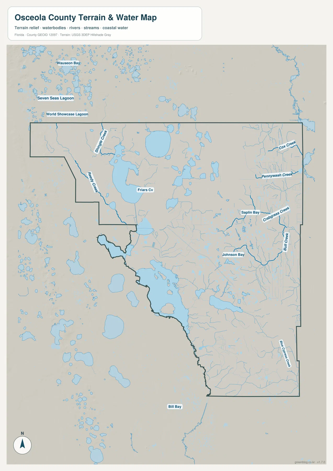
Several labels beyond the county boundary also help orient the viewer. Seven Seas Lagoon and World Showcase Lagoon appear northwest of the county, while the interior labels keep the focus on Osceola’s own creeks and lakes. These outside references are useful for regional orientation, but the most important county features are Shingle Creek, Reedy Creek, the large central lakes, and the many eastern and southern tributaries shown inside the green boundary.
Which Osceola County map is best for each question?
The county map is the best starting point for finding Kissimmee, St. Cloud, Celebration, Poinciana, Yeehaw Junction, and the main numbered roads in one view. The city map is better when the question is simply where the two ranked incorporated cities are located and how close they are to the Orange County side of the region. The water map is the better choice for tracing Shingle Creek, Reedy Creek, the eastern creeks, and the dense lake-and-wetland pattern across the southern interior.
For trip planning or regional orientation, US 192, US 441, State Road 417, and State Road 60 provide the clearest road framework. For classroom use, comparing the city map with the water map provides a simple way to explain how a county can contain both a major metropolitan edge and a much larger rural wetland landscape. For local geographic reference, the three maps work best together because each removes some clutter and emphasizes a different part of the same county.
Frequently Asked Questions
Which cities are ranked on the Osceola County city map?
The supplied city map ranks Kissimmee first and St. Cloud second. Both are in the northwest part of the county. Other familiar place names such as Celebration and Poinciana can be seen on the general county map, but they are not presented as ranked incorporated cities in this particular city index.
What roads are useful for locating Yeehaw Junction?
On the county map, US 441 runs south toward Yeehaw Junction and meets State Road 60 near the southern end of Osceola County. Looking north from that junction, State Road 15 and US 441 provide the clearest long-distance road reference back toward the central part of the county.
Which waterways stand out on the Osceola County water map?
Shingle Creek and Reedy Creek are prominent in the northwest, while Cox Creek, Pennywash Creek, Crabgrass Creek, Bill Creek, and Blue Cypress Creek appear farther east and south. The map also shows many lakes and named water bodies such as Friars Cove, Saplin Bay, Johnson Bay, and Bill Bay.
Map File Information
The ZIP below contains the Osceola County general map, city map, and water map as high-resolution A3 JPG files.
- Included Files: county map JPG, city map JPG, water map JPG
Related Maps
- Arcadia Roads and Peace River | DeSoto County Florida Map
- Baker County Florida Map
- Between the Aucilla and Withlacoochee: Madison County Florida Map
Sources and References
- U.S. Census Bureau, Osceola County QuickFacts – county statistics and general reference.
- Osceola County cities and communities – local place and community reference.
- Florida Department of Transportation official transportation map – major road reference.
- South Florida Water Management District, Shingle Creek – local waterway reference.
- South Florida Water Management District, Kissimmee River – regional water-system reference.
Green Map creates custom-edited map images using open geographic data sources such as geoBoundaries, Natural Earth, OpenStreetMap, and government open data. These maps are edited visual materials, not raw data files, and are provided for education, documents, presentations, and graphic reference.