Dubois County is easiest to orient from Jasper, the large settlement shown slightly west of the county’s center. You can download the supplied Dubois County maps on this page as high-resolution JPG files in one ZIP, making it easy to keep the full-size versions for printing or close viewing. Huntingburg lies to the south, Ferdinand is farther toward the southern edge, and Birdseye sits well to the east. Haysville and Dubois occupy the northern half, while a network of state roads and local routes ties the scattered communities together. The Patoka River crosses lower ground in the west and center, Patoka Lake anchors the eastern side, and the elevation surface becomes much rougher toward the east and northeast.
The maps show a county with a broad western settlement corridor and a more dissected eastern landscape. Jasper and Huntingburg are relatively close, with roads and developed areas forming the clearest concentration on the map. Farther east, places such as Celestine, Schnellville, and Birdseye are separated by longer stretches of rural terrain. The water map adds another layer: the Patoka River and its tributaries weave through the middle and west, while reservoirs and lakes punctuate the central, southern, and eastern parts of the county. On the elevation map, green lowlands dominate much of the west, while closely spaced ridges become increasingly prominent toward the east.
Each map answers a different practical question without requiring specialized GIS knowledge. The general county map is the best starting point for roads, towns, and the boundary. The city-connections map strips away most secondary labels so that the direction and spacing of Jasper, Huntingburg, Ferdinand, Holland, and Birdseye are easy to compare. The terrain-and-water map is useful when you need to locate the Patoka River, East Fork White River, Beaver Creek Reservoir, Patoka Lake, or the smaller lakes near Huntingburg and Ferdinand. The elevation map covers an actual range of roughly 106 to 246 meters, with a mean near 163 meters, and makes the west-to-east terrain contrast immediately visible.
Table of Contents
Jasper forms the main reference point for the western road network
On the general county map, Jasper is the largest and most visually prominent developed area. Several main roads meet around the city, making it a practical place to begin reading the county. Huntingburg lies south of Jasper, and Ferdinand is farther south near the county line. The three settlements are not perfectly aligned, but together they form the clearest north-to-south chain of larger communities in the western half of Dubois County.
The pattern becomes more varied away from that corridor. Ireland sits west of Jasper, Haysville appears to the north, and the community of Dubois is farther east in the northern half. A road from the Jasper area reaches toward Celestine and then continues in the direction of Birdseye near the eastern edge. In the south, Holland occupies the southwest side, while Bretzville and St. Anthony fill the space between Huntingburg and Ferdinand. Looking at road directions together with settlement names is more useful than treating the communities as a simple list.
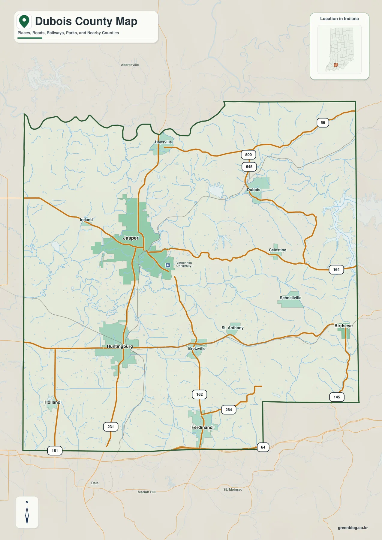
This map is intended for county-scale orientation rather than turn-by-turn navigation. A road line does not indicate current construction, traffic, closures, or travel time, and the shaded developed areas are not parcel boundaries. Use current transportation sources for driving decisions and official county or parcel records when you need a legal boundary or exact address. The value of the overview map is the way it puts settlements, roads, water, and the county outline on one page.
The five highlighted towns spread from Holland to Birdseye
The city-connections map simplifies the county to five highlighted centers: Jasper, Huntingburg, Ferdinand, Holland, and Birdseye. Jasper is the hub. The map reports direct distances of about 7 miles to Huntingburg, 12 miles to Holland, 13 miles to Ferdinand, and 15 miles to Birdseye. Those values are straight-line distances between the mapped points, not road mileage, so they should not be used to estimate driving time.
The simplified layout makes the county’s shape easier to understand. Huntingburg is the closest of the four highlighted places to Jasper and lies to the south. Ferdinand is farther south, close to the bottom of the county. Holland sits near the southwest side, while Birdseye is far to the east. Because Holland and Birdseye occupy opposite sides of the map, the city view quickly shows how widely the county’s communities are spread even before you add the smaller places visible on the general map.
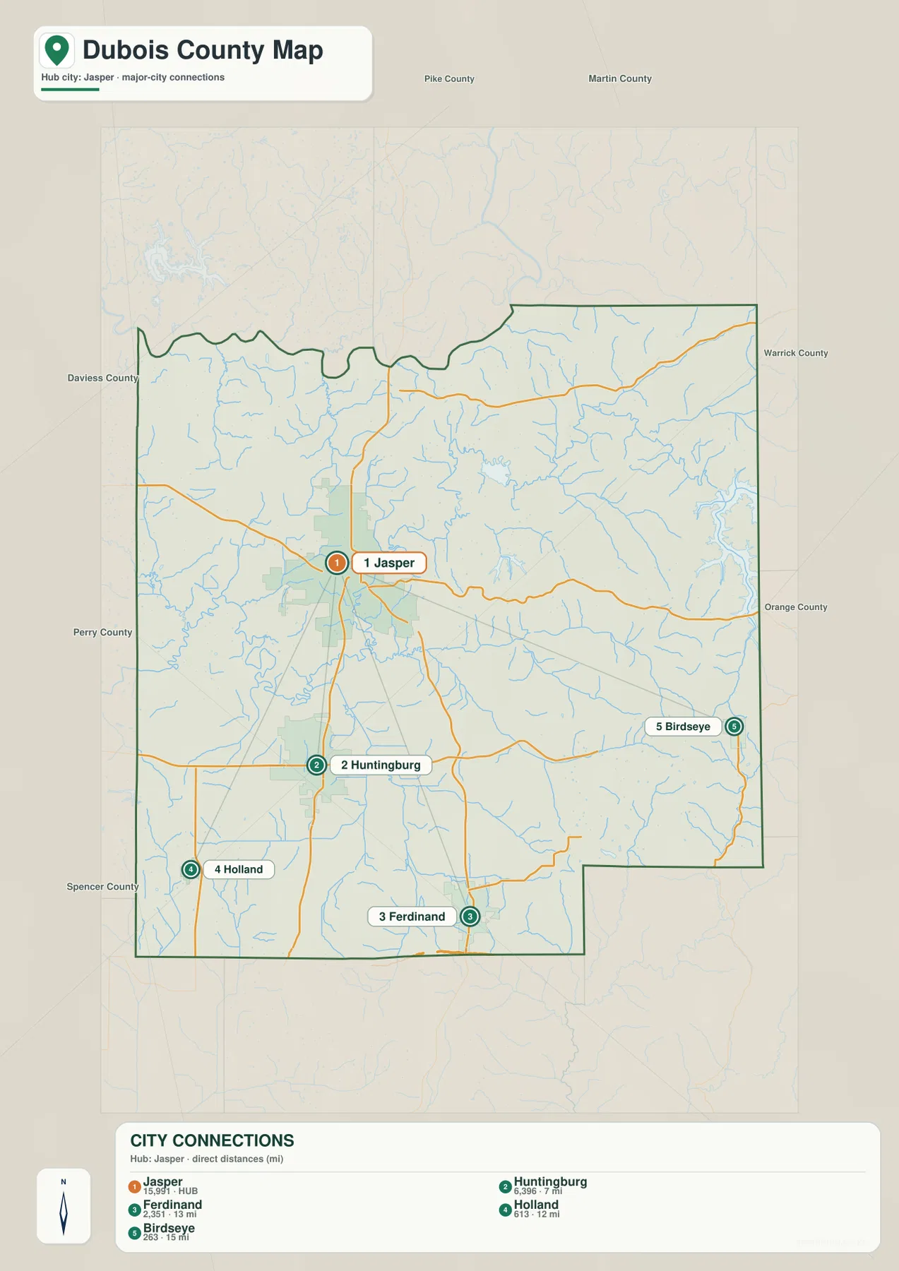
This view is especially helpful before reading the terrain maps. The Jasper–Huntingburg area is part of the more settled western side, while Birdseye lies near the hillier eastern margin. Ferdinand occupies a southern position where lakes and wooded terrain become more important. Once those positions are familiar, the water and elevation maps explain why communities on opposite sides of the county sit in noticeably different landscapes.
Patoka River lowlands and eastern lakes break up the terrain
The terrain-and-water map contains several large reference features. The Patoka River is labeled across the western and central part of the county, while the East Fork White River appears near the northwest edge. Straight River joins the network near the center-west. Numerous smaller blue channels branch across the low country, showing that Dubois County is crossed by many creeks and tributaries rather than organized around a single watercourse.
Patoka Lake is the dominant standing-water feature on the eastern side. Closer to the center, Beaver Creek Reservoir occupies a separate basin, and Olinger Lake sits near the Straight River corridor. The southern half includes Huntingburg Lake, City Lake, and Ferdinand Lake. Those smaller lakes are useful orientation points because they sit near the communities named for the same part of the county, while the much larger Patoka Lake defines the eastern edge of the water map.
Other named waterways help separate the eastern landscape into smaller valleys. Half Creek and Flat Creek appear east of the center, Lake Fork runs near the Patoka Lake side, and Anderson River is labeled in the southeast. The exact flow direction is less important for this page than the spatial relationship: major water features occupy distinct corridors, and the eastern creeks lie among more closely spaced ridges than the broad western drainage areas.
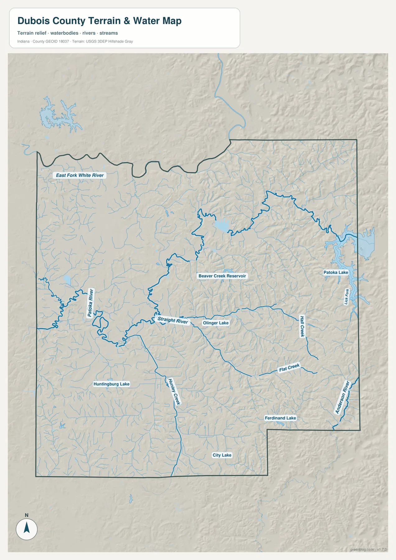
The blue lines and shaded relief should be treated as reference geography, not as a flood, boating, or water-quality product. A thicker blue line does not state discharge or depth, and the map does not define flood-insurance boundaries. Reservoir operations, fishing rules, navigation, and current water conditions require dedicated official sources. Here the purpose is to show where the county’s rivers, creeks, reservoirs, and lakes sit in relation to the settlements and terrain.
Elevation rises from broad western lowlands into a more ridged east
The elevation map spans roughly 106 to 246 meters, with a mean close to 163 meters. Much of the western and southwestern side is dark green, indicating the county’s lower ground. Moving east, the palette shifts through lighter greens and yellows into orange and brown. The eastern and northeastern sections contain the strongest ridge-and-valley texture, with many narrow high areas separated by lower creek corridors.
The Patoka River corridor helps explain the western lowland pattern. Green bands follow parts of the river and its tributaries, while higher ground appears between drainage routes. In the east, those differences occur over shorter distances: narrow ridges rise beside small valleys, and the terrain around the Patoka Lake side is visibly more broken than the broad low areas west of Jasper. The county therefore changes gradually overall but can change sharply within the eastern hill country.
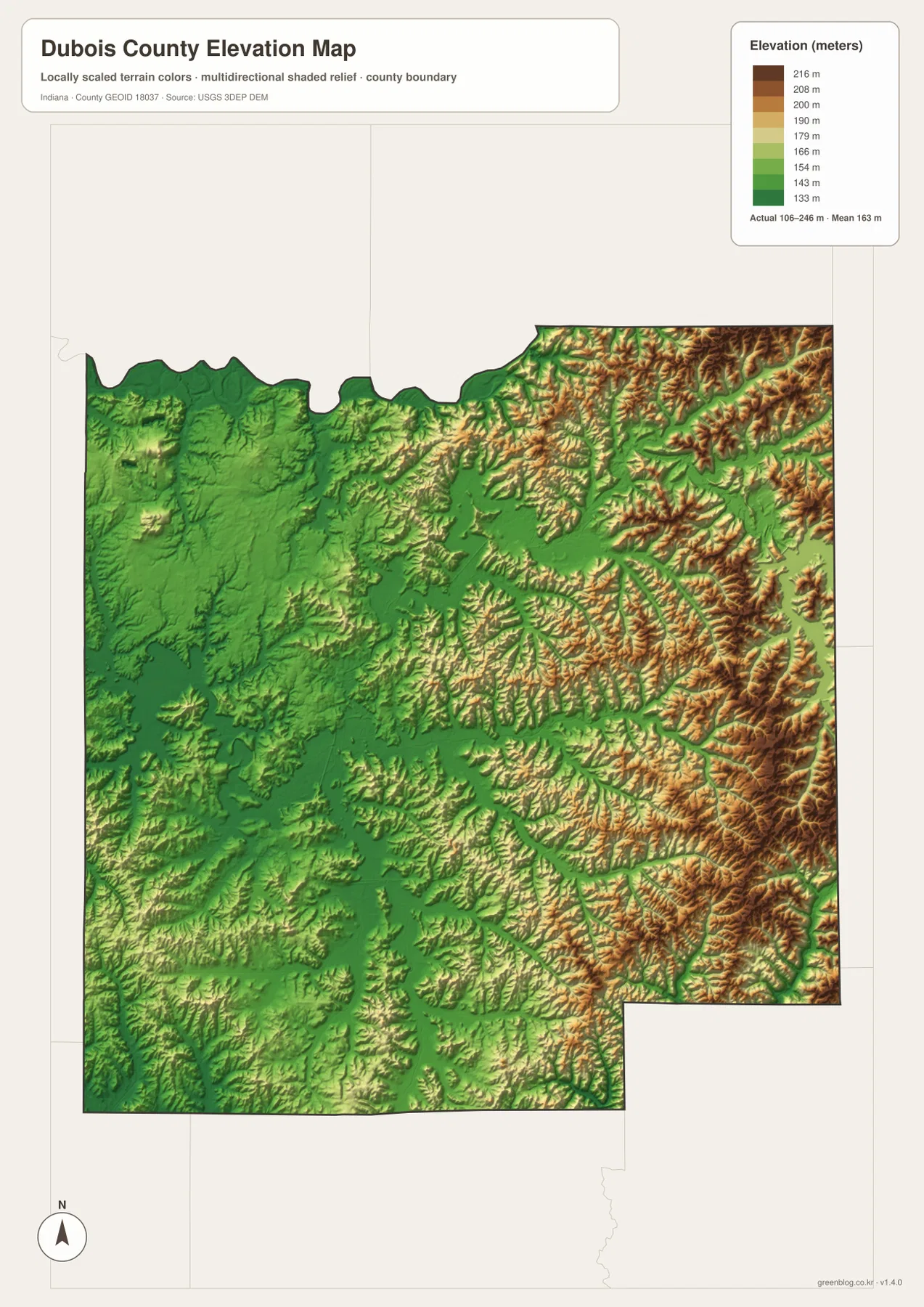
This is a generalized county-scale elevation surface, not a site survey. A single color represents a band of elevations, and small embankments, drainage ditches, or construction grading may not appear. Engineering, building design, parcel drainage, and exact site elevations require current survey-grade or official elevation data. For county orientation, however, the map clearly shows why the eastern side feels more rugged than the western side.
Matching settlements with water and relief makes the maps more useful
For basic orientation, begin with Jasper on the general map and trace the roads south to Huntingburg and Ferdinand. Then look east toward Celestine and Birdseye. That sequence establishes the main human geography before the simpler city-connections map shows the wider spacing between the highlighted communities. It also makes Holland’s southwest position and Birdseye’s eastern position easier to remember.
For natural geography, match a feature across the water and elevation maps. Find the Patoka River on the water map, then compare the same corridor on the elevation map to see the surrounding lowlands. Do the same around Patoka Lake and the eastern creeks, where ridges sit much closer together. Ferdinand and its nearby lake offer another useful southern reference because the area lies between the broad western lowlands and the more textured country to the east.
The WebP images on the page are optimized for quick viewing. If you need to zoom into road labels, creek names, small lakes, or shaded-relief detail, use the downloadable JPG originals. The ZIP contains the general county map, city-connections map, terrain-and-water map, and elevation map, each at 2572 × 3638 pixels. They are suitable for printing, classroom reference, trip planning, and offline study, but they do not replace legal boundary, flood, navigation, or engineering documents.
Official and local sources add context to the map pattern
Indiana’s county directory identifies Jasper as the county seat and lists Jasper, Huntingburg, Birdseye, Ferdinand, Holland, Dubois, and St. Anthony among the county’s cities and towns. That official context matches the pattern visible on the maps: Jasper is the strongest central reference, Huntingburg and Ferdinand form important southern centers, and Birdseye sits much farther east. The county map is therefore not simply a Jasper-centered urban page; it covers a dispersed group of communities spread across very different terrain.
Visit Dubois County describes the area as part of the rolling hills of southern Indiana and highlights Ferdinand State Forest and Patoka Lake among its major outdoor destinations. Those descriptions line up with the maps without replacing them. The elevation surface shows stronger ridges toward the east, while the water map gives Patoka Lake a clear position near the county’s eastern side. For trail details, facility rules, or operating information, use the current pages from the relevant park or local agency rather than relying on this county overview.
Frequently Asked Questions
Which map is best for comparing Jasper, Huntingburg, and Ferdinand?
The city-connections map is the quickest comparison. Jasper is the hub, with Huntingburg shown about 7 miles away and Ferdinand about 13 miles away by straight-line distance. Switch to the general map after that to see the road network and smaller communities between them. The direct-distance labels are not driving distances.
Why does eastern Dubois County look more rugged than the west?
The supplied elevation map shows broad lower terrain across much of the west and a denser ridge-and-valley pattern toward the east and northeast. The actual mapped range is about 106–246 meters. Small eastern creeks cut into the higher terrain, while the Patoka River and other drainage corridors occupy lower bands, producing the stronger relief visible on that side of the county.
What files are included in the Dubois County map download?
The ZIP contains high-resolution JPG versions of the general county map, city-connections map, terrain-and-water map, and elevation map. Each image is 2572 × 3638 pixels. They are useful for close viewing and printing, but they are not legal surveys, flood determinations, navigation charts, or engineering plans.
Map File Information
Download the general county, city-connections, terrain-and-water, and elevation maps of Dubois County as high-resolution JPG files for zooming, printing, and offline reference.
- File Type: JPG
Related Maps
Sources and References
- Indiana Counties — Dubois County seat and community listings
- Visit Dubois County — local parks, Ferdinand State Forest, and Patoka Lake context
- U.S. Census Bureau TIGER/Line Shapefiles — county boundaries, roads, and place data
- USGS National Hydrography — rivers, streams, lakes, and other water features
- USGS 3D Elevation Program — elevation and terrain data
Green Map creates custom-edited map images using open geographic data sources such as geoBoundaries, Natural Earth, OpenStreetMap, and government open data.
These maps are edited visual materials, not raw data files, and are provided for education, documents, presentations, and graphic reference.