Audubon County in southwestern Iowa is a rural county where small towns, north–south roads, and deeply branching stream valleys give the landscape its shape. Audubon is the main reference point near the north-central part of the county, while Exira and Brayton line up farther south along U.S. 71. Kimballton and Gray sit to the west and northwest. The general map is best for locating those communities and roads, the water map makes the Nishnabotna drainage much clearer, and the elevation map shows how the river valleys cut through higher rolling ground. High-resolution JPG versions of the maps shown on this page are available together in the download box below.
The county government lists five incorporated communities: Audubon, Brayton, Exira, Gray, and Kimballton. That five-town pattern is easy to see on the city-connections map because the places are not clustered around one metropolitan center. Audubon occupies the central reference position, Exira and Brayton extend the settlement line southward, Kimballton sits near the western boundary, and Gray is separated from the others in the northwest. Roads connect those places across a landscape that is far more dissected by creeks than the simple county outline suggests.
A useful way to read Audubon County is to follow three geographic threads at the same time. The first is the road pattern built around U.S. 71, Iowa 44, and Iowa 173. The second is the East Nishnabotna River corridor that runs through the county’s middle, with a different West Nishnabotna system in the northwest and South Raccoon drainage along the northeast side. The third is elevation: the map shows an actual county range of about 358 to 468 meters, with lower green valleys separating higher yellow-brown ridges. Together, those features explain the county better than a simple inventory of map types.
Table of Contents
U.S. 71 ties Audubon to Exira and Brayton
The most obvious highway on the general county map is U.S. 71. It enters from the north, passes through Audubon, then bends south toward Exira and Brayton. Audubon is easy to identify because the town label, street pattern, and civic symbols sit near the meeting point of several roads. Exira appears farther south along the same highway, while Brayton is close to the county’s southern edge. This makes U.S. 71 the simplest route line for understanding the north-to-south relationship among three of the county’s five incorporated towns.
South of Audubon, Iowa 44 crosses the county from west to east and meets the U.S. 71 corridor. Following it west leads toward Kimballton, where Iowa 173 is also labeled. The county’s Kimballton page identifies the community as being on Highway 173, so that road is a useful anchor when reading the western side of the map. The combination of a strong north–south road and a west–east road makes the middle of the county easy to orient even before the smaller rural roads are considered.
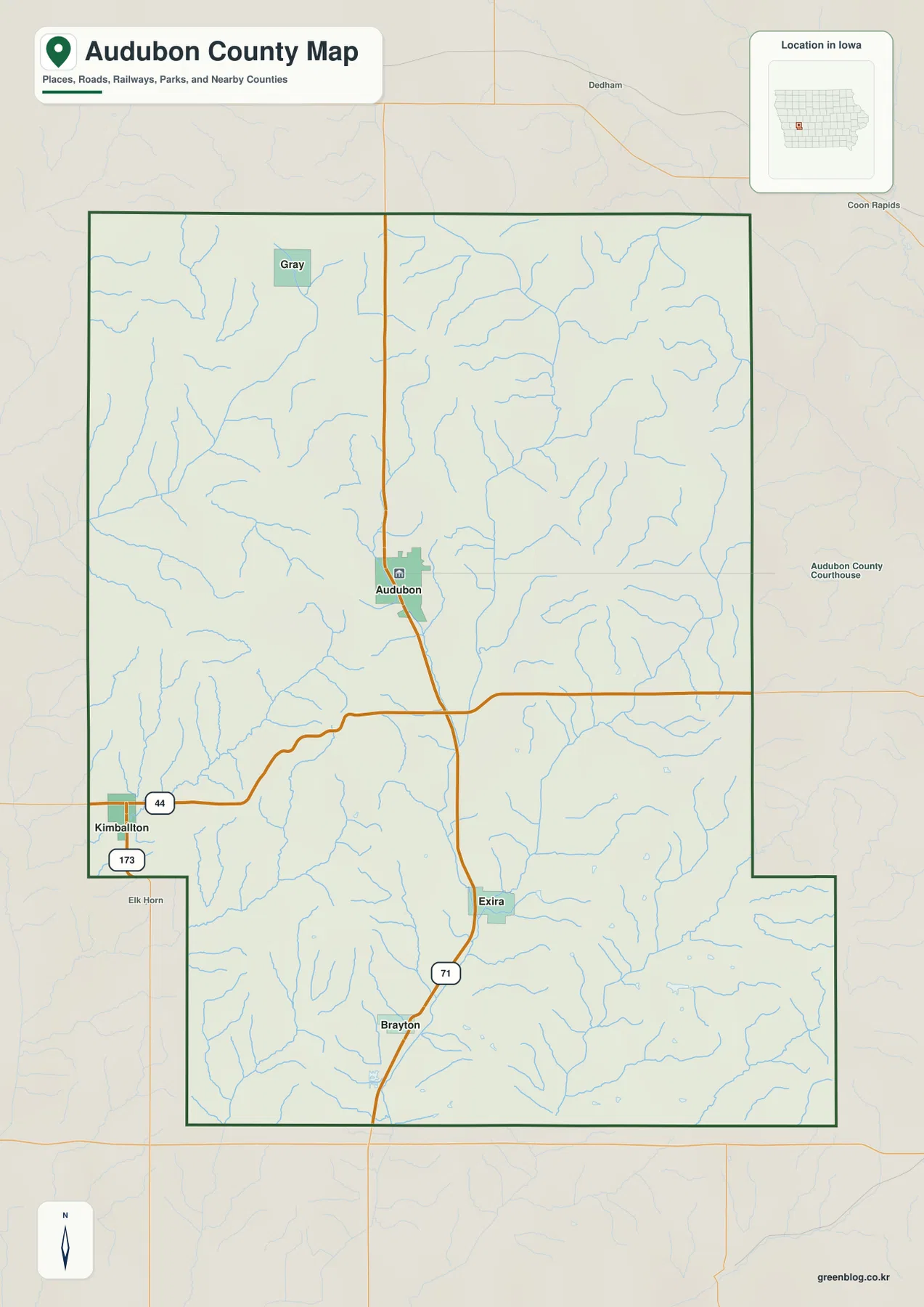
Kimballton lies close to the western county line, and Gray is farther north in the northwest quarter. Their road setting differs from the Audubon–Exira line because they are not arranged along the same U.S. 71 corridor. Kimballton is connected into the Iowa 44 and 173 network, while Gray appears among lighter local roads. The map also shows nearby places outside the county, which helps establish how close the western communities are to the neighboring county line.
Blue stream lines are almost everywhere on the general map. Even where roads form long, fairly straight sections, the creeks twist and branch repeatedly. Short tributaries are especially noticeable around Audubon, between Audubon and Exira, and across the western part of the county. That contrast matters because a regular road grid can make the land look flatter than it is. The water and elevation maps reveal that many of those straight roads cross a landscape of small valleys and narrow ridges.
The five towns form a spread-out network rather than one cluster
The city-connections map uses Audubon as the hub and simplifies the county to the five incorporated towns. It labels Exira at about 9 miles from Audubon, Gray at about 9 miles, Kimballton at about 10 miles, and Brayton at about 12 miles. Those figures are direct, straight-line distances between mapped points. They are not driving mileage, so the real road distance will depend on the route, curves, intersections, and the exact starting point within each community.
Direction is as useful as distance on this map. Gray is northwest of Audubon, Kimballton is west-southwest, Exira is south, and Brayton lies still farther south. The county’s official cities page confirms the same five incorporated places. That pattern gives Audubon a central role without turning the county into a single-city area. The western towns and southern towns remain distinct reference points for different parts of the rural landscape.
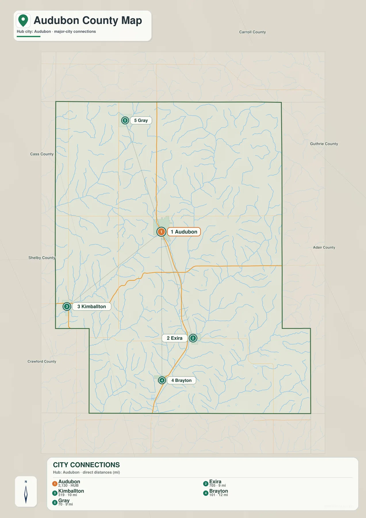
The map also prints reference numbers beside the communities. They are useful for distinguishing the map’s city labels, but this page does not treat them as current population counts. Anyone needing current demographic statistics should consult the latest Census data separately. For geographic reading, the more important message is the distribution: Audubon is the hub, while the other four towns reach into different quadrants of the county.
Combining the city map with the general road map gives a better sense of actual travel. Exira is roughly 9 miles away in a straight line, but the route follows the U.S. 71 corridor rather than an imaginary straight segment. Kimballton is a similar straight-line distance from Audubon but requires a westward route. Brayton continues south along U.S. 71, and the county’s Brayton page notes that the town is about three miles north of I-80. That makes Brayton especially useful for understanding how the county connects toward the interstate just beyond the southern side.
The Nishnabotna rivers divide the county into different valley systems
The terrain-and-water map is dominated by the East Nishnabotna River. A thick blue line enters from the north-central part of the county, runs south through the broad middle valley, and continues toward the southern boundary. Numerous small tributaries feed it from both sides. The result is not a single narrow channel but a branching valley system that reaches far into the surrounding uplands. This is the feature that best explains the long green lowland seen later on the elevation map.
The northwest belongs to a different set of named waterways. West Nishnabotna River and East Branch West Nishnabotna River are labeled near the western side, with smaller streams such as Indian Creek, Elkhorn Creek, Buck Creek, and Bluegrass Creek cutting through nearby ground. These channels help distinguish the Gray–Kimballton side of the county from the central East Nishnabotna corridor. A reader looking only at the county boundary would miss that internal difference.
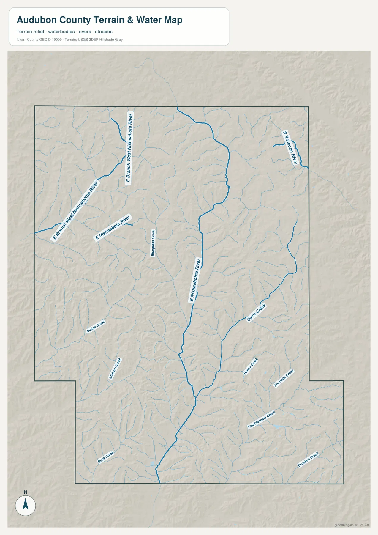
The eastern side adds another drainage direction. South Raccoon River is labeled near the northeast boundary, while Davids Creek, Honey Creek, Fourmile Creek, Troublesome Creek, and Crooked Creek occupy parts of the eastern and southeastern landscape. Their orientation shows that not every stream in Audubon County belongs to the same valley. The county sits across several sets of small drainage divides, and the relief map makes those divides visible as higher ridges between the green stream corridors.
This water layer is a geographic reference, not a flood, parcel, or navigation product. A blue line shows the location of a mapped stream or river, but it does not tell you the current water level, legal access, flood insurance zone, channel depth, or whether a section is navigable. Current water conditions and hazard information should be checked with the responsible agencies. For this article, the water map is most useful for understanding why the county’s valleys branch in different directions.
A 358–468 meter range exposes the long central lowland
The elevation legend reports an actual county range of about 358 to 468 meters, with a mean near 417 meters. Lower ground is shown in green, while higher ridges shift through yellow and brown. The strongest pattern is a long green corridor running through the middle of the county from north to south. When the elevation and water maps are compared, that low corridor aligns with the East Nishnabotna River and the valleys of its tributaries.
Higher terrain appears on both sides rather than being confined to one corner. Brown and orange ridge tops are common in the west and northwest, but eastern and northeastern interfluves also rise above the major stream valleys. Small green fingers cut into those higher areas wherever creeks have carved lower ground. The southern part of the county continues the same pattern: the main Nishnabotna lowland stays green while narrow tributary valleys divide the adjacent ridges.
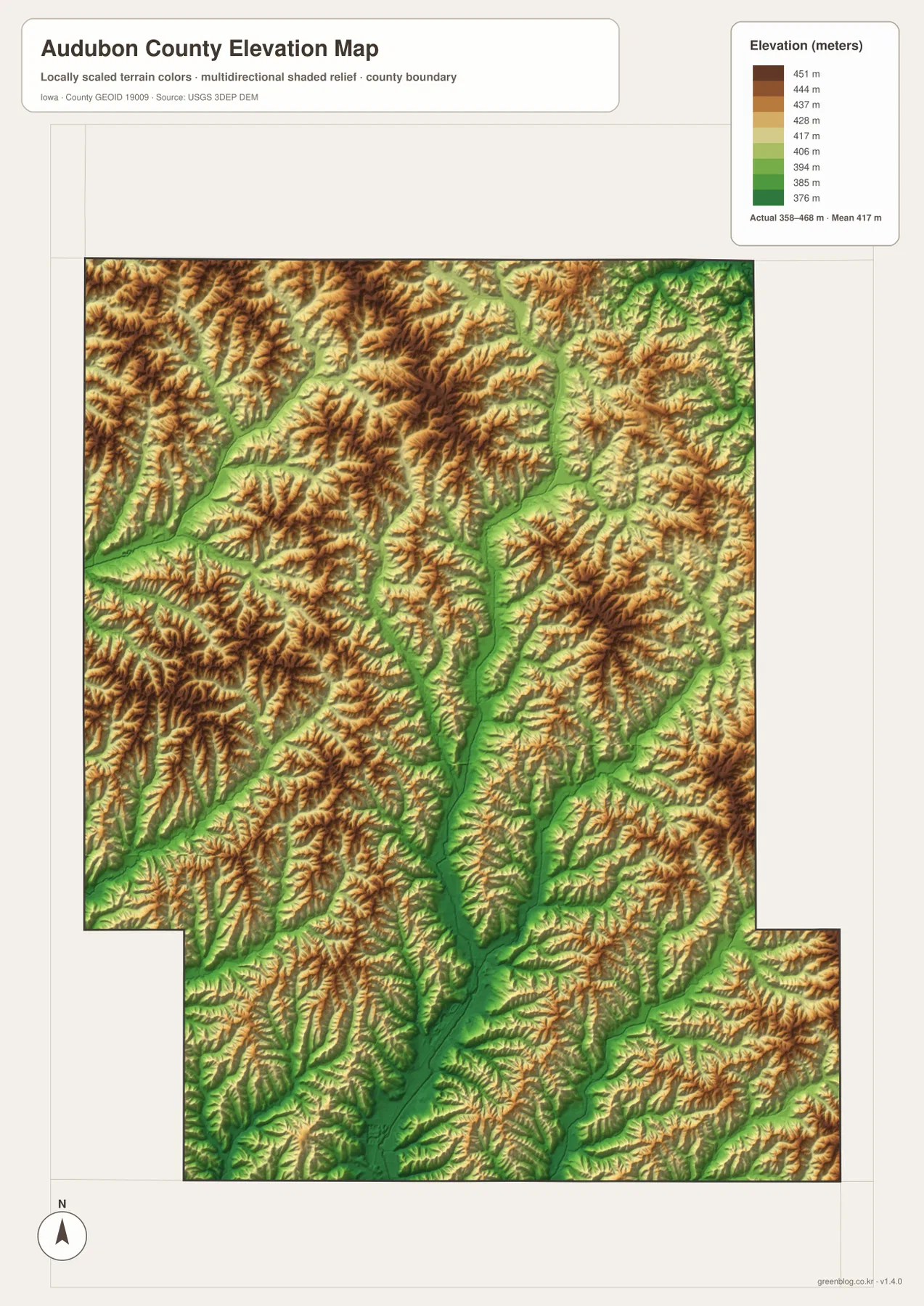
This relief changes the impression created by the road grid. Long straight road segments suggest open farm country, but the elevation colors show repeated changes in height beneath that grid. A road may cross several tributary valleys even when it looks almost straight on the general map. The same is true around Audubon and Exira: their road connection is simple to follow, yet the surrounding ground is broken by numerous side valleys feeding the main river.
The elevation surface is intended for county-scale comparison. It is useful for identifying lower valleys, higher ridges, and the general shape of the terrain, but it is not a survey-grade product. It should not be used to determine construction elevations, parcel grades, drainage design, or precise slopes. For those tasks, a higher-resolution elevation dataset or field survey is required.
Audubon and Exira make more sense when roads and valleys are viewed together
Audubon looks like a road center on the general map, but the water and elevation layers add an important second half of the story. The East Nishnabotna River lies to the east of the city, and lower tributary corridors extend through the surrounding countryside. That means Audubon is not simply a dot near the middle of a rectangular county. It occupies higher rolling ground beside a major north–south river valley, with roads crossing between ridges and lowlands.
Exira changes in a similar way when the layers are compared. The city-connections map reduces it to a point about 9 miles south of Audubon, while the general map ties it directly to U.S. 71. On the water and elevation maps, Exira sits near the continuing East Nishnabotna system and the low corridor that runs toward the southern boundary. Seeing all three views together explains why the Audubon–Exira relationship is both a road connection and a valley connection.
Kimballton and Gray belong to a different part of the county’s geography. Their western position places them closer to the West Nishnabotna system and its branches. Kimballton is easy to connect with Iowa 44 and 173, while Gray sits farther north among smaller roads. When the water map is added, the difference between the western drainage and the central East Nishnabotna corridor becomes much clearer.
The northeast has yet another emphasis. Few large community symbols compete for attention there, but South Raccoon River and the surrounding creek valleys create a strongly dissected relief pattern. This is why the map set works best as a sequence rather than as four unrelated pictures. The general map supplies names and roads, the city map simplifies direction and distance, the water map identifies the valleys, and the elevation map shows the height changes around those valleys.
Choose the map according to the question
Start with the general county map when you need roads, towns, streams, and the county boundary on one page. It is the easiest way to follow U.S. 71 from Audubon toward Exira and Brayton, trace Iowa 44 toward Kimballton, and see where Gray sits in the northwest. It also provides enough surrounding context to understand which side of the county a road or creek occupies.
Use the city-connections map when the main question is how the five incorporated towns relate to Audubon. Its straight-line distance labels are convenient for comparing direction and spacing, but they should never be substituted for road mileage. For river names and branching tributaries, move to the terrain-and-water map. For the height of the valley floor relative to surrounding ridges, use the elevation map after locating the relevant river or creek.
A practical Audubon-to-Exira example uses three layers. First, find both towns and U.S. 71 on the general map. Second, note the roughly 9-mile straight-line separation on the city map. Third, compare the East Nishnabotna River on the water map with the long green lowland on the elevation map. A Kimballton-focused example works differently: start with Iowa 44 and 173, then switch to the West Nishnabotna side of the water map and the dissected western ridges on the elevation layer.
The downloadable archive contains the high-resolution JPG originals corresponding to the general county map, city-connections map, terrain-and-water map, and elevation map shown above. Each image is 2572 by 3638 pixels in portrait orientation, so small labels and tributaries remain more readable when enlarged than they are in the WebP previews embedded in the article. Review the previews first, then use the full files for closer study, printing, or offline reference.
Use the maps for geographic orientation, not live or legal decisions
The road and city maps are orientation tools rather than live navigation products. Construction, closures, winter conditions, and local access can change after a static map is produced. The 9-to-12-mile city labels are straight-line measurements and do not account for the curves of U.S. 71, Iowa 44, local roads, or the exact origin and destination inside a town. Current routing should always come from an up-to-date road source.
The water map also has a limited purpose. It locates rivers and creeks and helps explain the shape of the terrain, but it does not show flood insurance boundaries, property ownership, channel depth, water quality, or boating access. A river can be mapped accurately for geographic context without answering any of those separate questions. Current stream conditions should be checked with USGS or the appropriate local and state agencies.
The 358–468 meter elevation range is likewise a county-scale terrain summary. It works well for distinguishing the long East Nishnabotna lowland from the higher ground on either side and for seeing how tributary valleys cut into the ridges. It cannot replace site-specific surveying or engineering-grade elevation data. The safest use is comparative: identify a low valley or higher ridge, then return to the road and water maps to see which named place or stream occupies that part of the county.
Audubon County rewards this layered reading because its five towns are spread across more than one drainage system. Audubon and Exira are tied to the U.S. 71 and East Nishnabotna corridor, Kimballton and Gray sit closer to the western Nishnabotna side, and the northeast reaches toward South Raccoon River. Roads, water, and relief therefore tell different parts of the same story. Comparing them produces a much clearer picture than treating the county as a flat rectangle filled with evenly spaced roads.
Frequently Asked Questions
Why does the city map show Audubon and Exira as about 9 miles apart?
The city-connections map measures a straight line between the mapped town points. It is not driving mileage. For an actual trip, use the general map to see the U.S. 71 corridor and then check current road directions for the exact route and distance.
Which map best shows the East and West Nishnabotna river systems?
The terrain-and-water map is the best starting point. It labels East Nishnabotna River through the central part of the county and West Nishnabotna River with East Branch West Nishnabotna River in the northwest. Add the elevation map to see how both systems occupy lower green valleys between higher ridges.
What is included in the downloadable ZIP?
The ZIP contains four high-resolution JPG files matching the general county map, city-connections map, terrain-and-water map, and elevation map shown in the article. Each image is 2572×3638 pixels, providing more detail for enlargement or printing than the WebP page previews.
Map File Information
Download the Audubon County maps shown in this article as high-resolution JPG files.
- Printable Size: 2572×3638 pixels each
Related Maps
Sources and references
- Audubon County official website — county location and community overview
- Audubon County – Kimballton — Highway 173 and Kimballton location reference
- Audubon County – Brayton — Highway 71 and I-80 location reference
- Iowa Department of Transportation – Audubon County Maps — county and city road-map references
- USGS National Hydrography — hydrography reference data
- USGS 3D Elevation Program — elevation reference data
Green Map creates custom-edited map images using open geographic data sources such as geoBoundaries, Natural Earth, OpenStreetMap, and government open data.
These maps are edited visual materials, not raw data files, and are provided for education, documents, presentations, and graphic reference.