Harris County lies in west-central Georgia, where Hamilton serves as the county seat, Pine Mountain occupies the higher northern side, and Shiloh, Waverly Hall, Cataula, and Ellerslie spread across the east and south. The map set on this page separates those features into readable views rather than forcing roads, water, and terrain onto one crowded image. The general reference map shows the principal places and numbered routes, the city-connections view uses Hamilton as its hub, the water map highlights named creeks and lakes, and the elevation map reports an actual range of about 102 to 424 meters with a mean of 211 meters. Four high-resolution A3 JPG originals are available together in the downloadable ZIP.
Hamilton is the easiest place from which to understand the county. Pine Mountain sits to the north, Shiloh is near the eastern side, Waverly Hall lies southeast, and Cataula and Ellerslie provide southern references. Antioch and Piney Grove appear in the western and southwestern interior. The physical landscape adds another layer: a long high ridge crosses the northern and northeastern part of Harris County, while connected water along the western boundary and numerous creek valleys occupy lower terrain. Looking at settlement, water, and relief together gives the county a much clearer shape than a boundary outline alone.
Table of Contents
Hamilton, Pine Mountain, and the County’s Numbered Roads
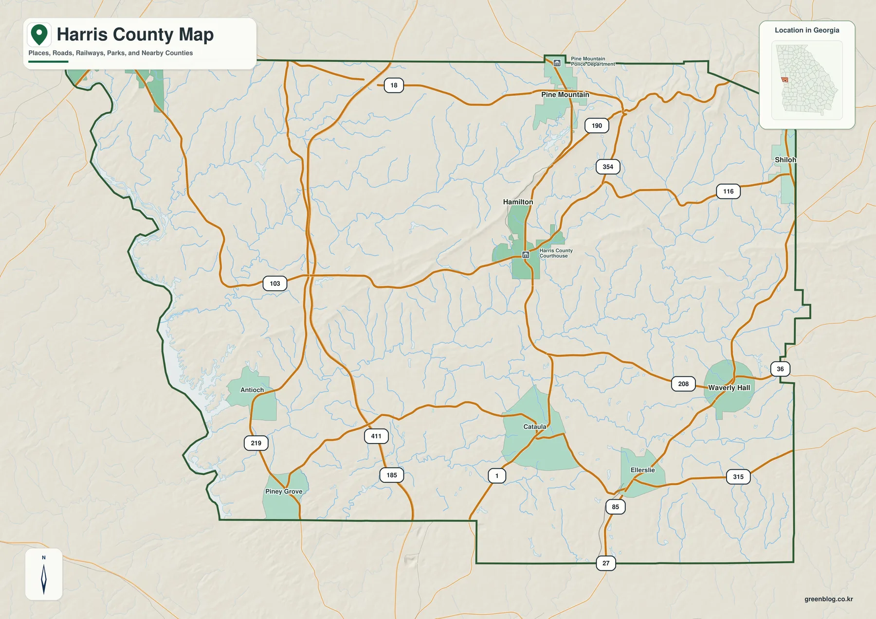
Hamilton appears slightly north of the county’s center and is marked with the Harris County Courthouse, making the administrative core easy to locate. Pine Mountain lies to the north and carries a Pine Mountain Police Department label nearby. Route 18 crosses the northern portion of the map, while 190 provides a north-south reference around Pine Mountain. East of Hamilton, 354 and 116 help establish the direction toward Shiloh. These labels are useful for broad county orientation rather than turn-by-turn navigation.
The road pattern becomes more dispersed to the south and southeast. Route 208 reaches toward Waverly Hall, and 36 appears close to the eastern county side. Around Ellerslie, 85 and 315 provide strong local references; farther south, 27 and 1 are visible near the lower edge. The western and southwestern interior includes 185, 219, and 411 around the Antioch and Piney Grove side, while 103 crosses the west-central county. Together, the routes show that Harris County is connected through several separate corridors rather than one dominant highway line.
The spaces between those roads are filled with thin blue tributaries. They are especially dense across the west, central hills, and southern interior. That detail matters because it shows why the roads often curve and why communities are separated by broad rural terrain rather than a regular street grid. The general map works best as the first overview: Hamilton provides the administrative anchor, major place names establish direction, and the stream network hints at the terrain that becomes much clearer on the water and elevation maps.
Straight-Line Connections from Hamilton
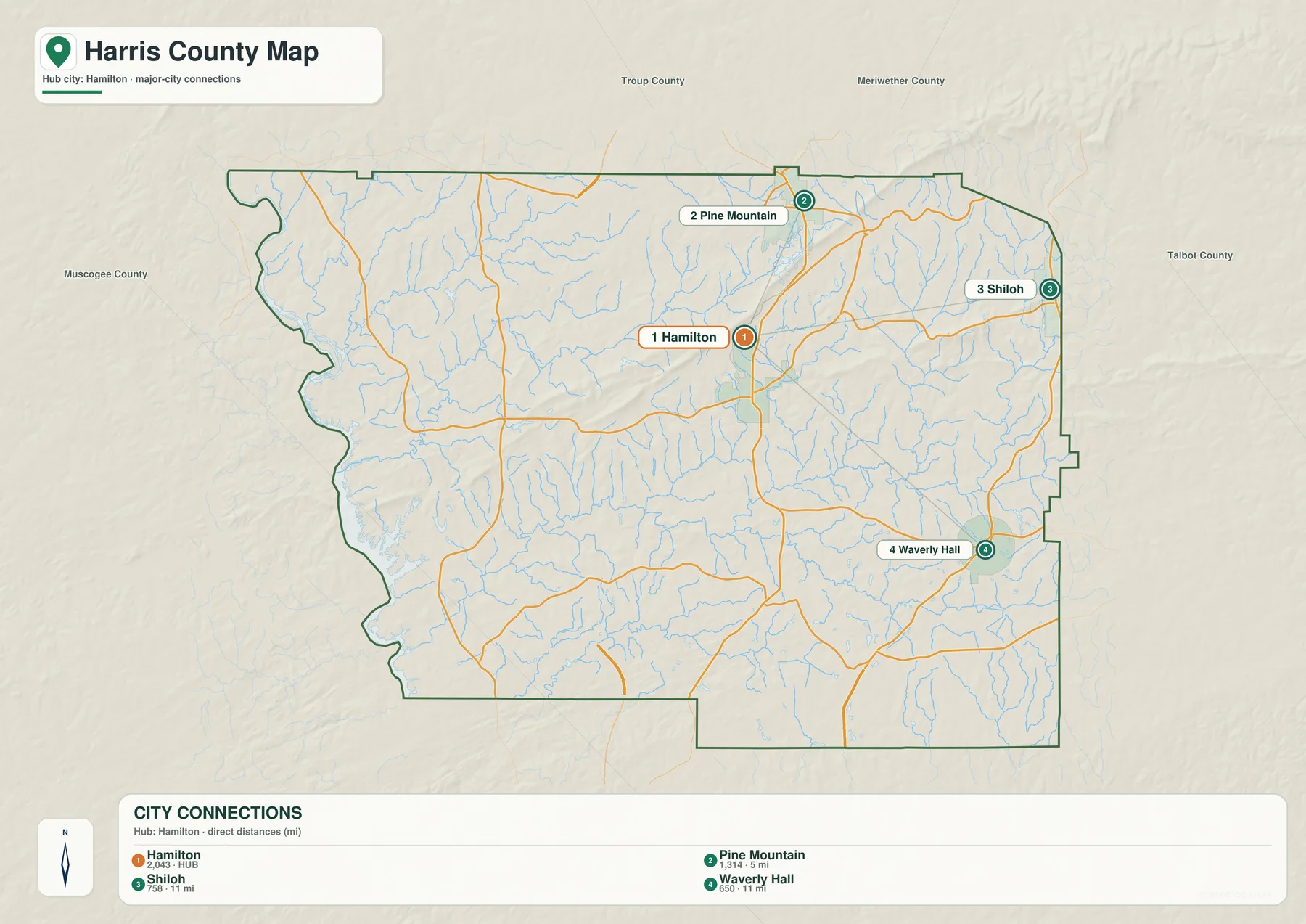
The city-connections map deliberately removes much of the road and landmark detail. Its CITY CONNECTIONS panel places Hamilton at 2,043 as the hub, followed by Pine Mountain at 1,314, Shiloh at 758, and Waverly Hall at 650. Those figures are the values printed on the supplied graphic and are included only to explain the ranking used by the map. They should not be read as newly verified population estimates; current official figures can be checked through the Census QuickFacts source listed below.
The connector labels show Pine Mountain about 5 miles from Hamilton, while Shiloh and Waverly Hall are each shown about 11 miles away. These are straight-line distances, not driving mileage. Actual road travel varies with the chosen route and the exact start and end points. Even so, the comparison is useful: Pine Mountain is relatively close to Hamilton, while Shiloh and Waverly Hall sit at similar distances in different directions.
Troup, Meriwether, Talbot, and Muscogee counties are labeled outside the Harris County boundary for regional orientation. The city graphic also makes the internal pattern easy to see. Hamilton is near the middle, Pine Mountain is close to the northern side, Shiloh is near the eastern edge, and Waverly Hall lies southeast. The general map adds Cataula, Ellerslie, Antioch, and Piney Grove, so the simplified city view should not be interpreted as a complete list of every named community.
| Place | Displayed value | Straight-line distance from Hamilton | General position |
|---|---|---|---|
| Hamilton | 2,043 | hub | central county |
| Pine Mountain | 1,314 | about 5 mi | north |
| Shiloh | 758 | about 11 mi | east |
| Waverly Hall | 650 | about 11 mi | southeast |
Western Water, Mountain Creeks, and Southern Tributaries
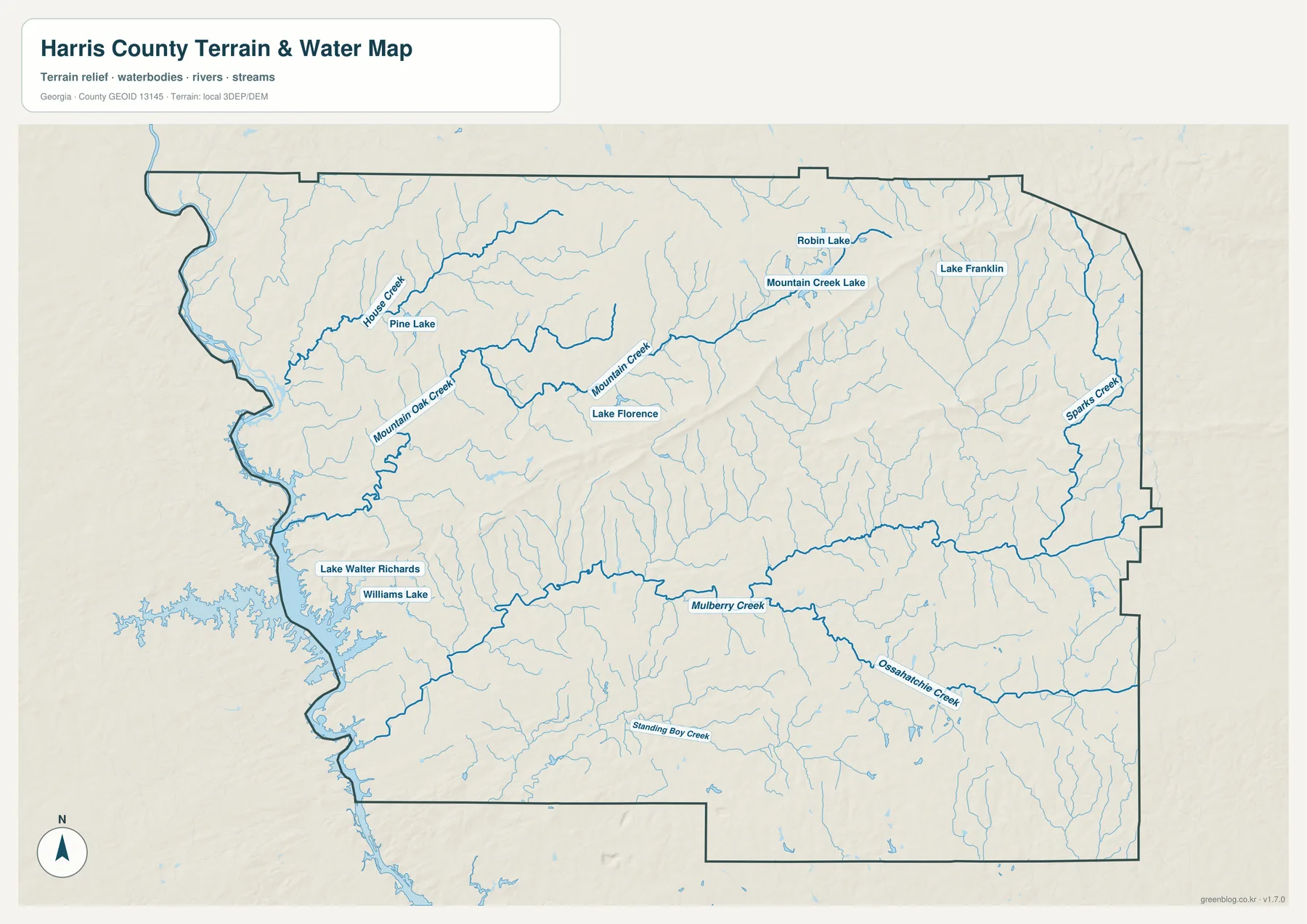
The western side contains the most visually dominant connected water on the supplied water map. The older source article identifies Lake Harding as part of Harris County’s local setting, but the map preview itself emphasizes the shoreline and tributary network rather than printing that lake name. For that reason, the safest way to use the graphic is to focus on the visible western water corridor and the creeks that reach it. This lower western landscape contrasts strongly with the long higher ridge visible farther north and east.
Horse Creek is a strong named channel in the northwest, and Mountain Oak Creek descends toward the western water from the interior. Farther east, Mountain Creek follows a long valley near Lake Florence and Mountain Creek Lake. Pine Lake provides another small western reference, while Robin Lake and Lake Franklin appear in the northeastern half. The pattern is not dominated by one inland lake; instead, many smaller named waters and tributaries occupy the valleys between rolling and ridged terrain.
Across the middle and south, Mulberry Creek becomes one of the longest named references. Ossahatchie Creek occupies a winding southeastern valley, Standing Boy Creek follows the southern interior, and Sparks Creek lies near the eastern county side. Lake Walter Richards and Williams Lake appear close together in the southwest. These names make it possible to locate parts of Harris County by water as well as by roads and communities.
This water view is intended for county-scale geographic orientation. It does not establish parcel flood status, private-property boundaries, water depth, boating conditions, or legal shoreline access. Those decisions require current specialized records. For map reading, the useful relationships are Horse Creek and Mountain Oak Creek near the western water, Mountain Creek in the central-northern hills, Mulberry Creek across the middle, and the Ossahatchie–Standing Boy–Sparks Creek valleys in the south and east.
Elevation from About 102 to 424 Meters
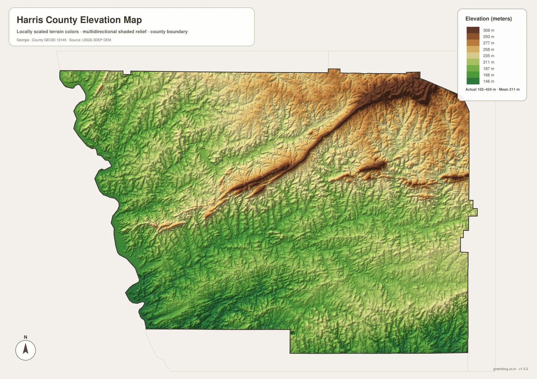
The elevation legend gives Harris County an actual range of approximately 102 to 424 meters, with a mean of 211 meters. The highest relief is concentrated in the northeast, where dark brown terrain forms a broad high area. From that section, a long ridge extends southwestward across the northern half of the county. The Pine Mountain area on the general map lies close to this high terrain, making the name a useful geographic reference even without assigning a precise peak to the city label.
The ridge is not a single smooth wall. Narrow valleys cut across and alongside it, and several of the creeks on the water map occupy those lower paths. West of the ridge, terrain drops into greener rolling country and eventually toward the connected water along the county boundary. Hamilton sits between the highest northeastern ground and the lower western and southern areas, rather than occupying either extreme.
The eastern and southeastern sections remain hilly but are less continuously high than the strongest northeastern ridge. Around Shiloh and Waverly Hall, short ridges alternate with creek valleys. Farther south around Cataula and Ellerslie, green lower ground becomes more common, although the relief never becomes perfectly flat. This mixture of hills and drainage valleys explains why the county can look rural and open on the city map while still showing considerable terrain variation on the relief view.
The elevation colors are designed for broad comparison across Harris County. An exact height for a building lot, road project, drainage plan, or property survey requires finer elevation data and, when appropriate, field measurements. For a geography lesson, county profile, or presentation, the 102–424 meter range is useful because it clearly separates the high Pine Mountain-side ridge from lower western water and southern creek valleys.
Hamilton, Pine Mountain, and the County’s Western Water Setting
The source material in the package states that Harris County was established in 1827 and describes Pine Mountain, Callaway Gardens, Lake Harding recreation, agriculture, and commuting toward the Columbus area as parts of the county’s local background. The four maps here do not measure tourism, agriculture, or commuting. Instead, they provide the geographic framework behind those subjects: Hamilton as the county seat, Pine Mountain near the higher northern ridge, western connected water, scattered eastern and southern communities, and a dense network of rural creeks.
Hamilton and Pine Mountain illustrate how the maps complement one another. The city graphic places the two about 5 straight-line miles apart. The general map shows the road connections, while the elevation view reveals that Pine Mountain sits closer to the county’s strongest high relief. Moving west from that high ground brings the connected water corridor and lower valleys into view; moving south leads toward Cataula, Ellerslie, and a different set of creek systems. The county is therefore easier to understand as a combination of ridges, valleys, communities, and water rather than as one uniform landscape.
The general reference map is the best starting point when roads, communities, and the county outline all matter. The Hamilton-centered city view provides a cleaner comparison of Pine Mountain, Shiloh, and Waverly Hall. The water map is the stronger reference for Horse Creek, Mountain Creek, Mulberry Creek, Ossahatchie Creek, and the named lakes, while the elevation map explains the long high ridge and lower western terrain. Because the four files use the same county boundary, they can be compared directly in a class, report, or presentation.
Frequently Asked Questions
What makes Hamilton the main county reference?
Hamilton is the county seat. The general map labels the Harris County Courthouse there, and the city-connections graphic also uses Hamilton as the hub for Pine Mountain, Shiloh, and Waverly Hall.
Are the 5- and 11-mile city labels road distances?
No. The graphic shows straight-line distances from Hamilton: about 5 miles to Pine Mountain and about 11 miles to both Shiloh and Waverly Hall. Actual driving mileage depends on the chosen roads and exact endpoints.
Which named water features are easiest to locate?
Horse Creek, Mountain Oak Creek, Mountain Creek, Mulberry Creek, Ossahatchie Creek, Standing Boy Creek, and Sparks Creek are clearly labeled. Pine Lake, Lake Florence, Mountain Creek Lake, Robin Lake, Lake Franklin, Lake Walter Richards, and Williams Lake provide additional reference points.
What is included in the downloadable A3 ZIP?
The archive contains four large JPG originals covering the county reference, Hamilton-centered city connections, waterways, and elevation. Separating those themes keeps road labels, city relationships, water names, and relief easier to read when printed or placed in a document.
Map File Information
Harris County A3 Map Files
- Included Files: General county, city, water, and elevation maps
- File Type: Four high-resolution A3 JPG files bundled in one ZIP archive
- Intended Use: Printing, education, presentations, and map-based projects
Related Maps
Harris County Data and Map References
- U.S. Census Bureau QuickFacts: Harris County – current official county statistics
- Harris County official history – county establishment and local historical background
- Harris County official community guide – local cities and community references
- Census TIGER/Line boundary resources – county and neighboring-boundary reference geometry
- USGS hydrography resources – reference data for creeks, lakes, and other mapped waters
- USGS 3DEP elevation resources – source elevation data for comparing the 102–424 meter terrain range
Green Map creates custom-edited map images using open geographic data sources such as geoBoundaries, Natural Earth, OpenStreetMap, and government open data. These maps are edited visual materials, not raw data files, and are provided for education, documents, presentations, and graphic reference.