Atchison County occupies Missouri’s far northwestern corner, where the Missouri River forms a long western boundary and Iowa lies immediately to the north. Tarkio and Rock Port are the easiest places to use as anchors. Tarkio sits at the U.S. 59 and U.S. 136 crossroads, while Rock Port lies closer to I-29 and contains the Atchison County Courthouse. Fairfax, Westboro, and Watson are smaller communities spread across the county rather than part of one continuous urban area. The general, city-connections, water, and elevation maps on this page are also available as high-resolution JPG originals in the ZIP download below.
The county becomes much easier to understand when the Missouri River lowlands are compared with the ridged interior. The western floodplain around the Missouri and Nishnabotna rivers is broad, low, and nearly flat on the elevation image. East of Rock Port, the surface changes quickly into narrow upland ridges cut by Rock Creek, the Tarkio River, and several Tarkio-named tributaries. The legend reports an actual elevation range of about 262 to 370 meters and a mean near 304 meters.
Table of Contents
Tarkio’s U.S. 59–136 crossroads and Rock Port’s I-29 access
Tarkio sits slightly north of the county’s center and is the clearest interior road junction. U.S. 59 runs north–south through the town, while U.S. 136 crosses east–west. Following U.S. 59 south leads toward Fairfax, and heading west on U.S. 136 connects toward Rock Port and the I-29 corridor. This road arrangement explains why the city-connections map uses Tarkio as its hub even though it is not the county seat.
Rock Port lies west-southwest of Tarkio and much closer to I-29. Missouri 275 is also labeled in the Rock Port area, with Phelps City and the Missouri River plain farther west. The Atchison County local-government page places the courthouse at 400 S. Washington Street in Rock Port, so Rock Port is the administrative reference while Tarkio functions as a convenient inland road reference. The distinction is useful when comparing the general map with local-government information.
Watson occupies a very different setting near the northwestern river lowlands. Westboro is north of Tarkio, while Fairfax lies south along the U.S. 59 side of the county. Once those communities are placed around Tarkio and Rock Port, the county’s settlement pattern becomes clear: small towns are spread between river-bottom roads, interstate access, and inland highways rather than concentrated in one corridor.
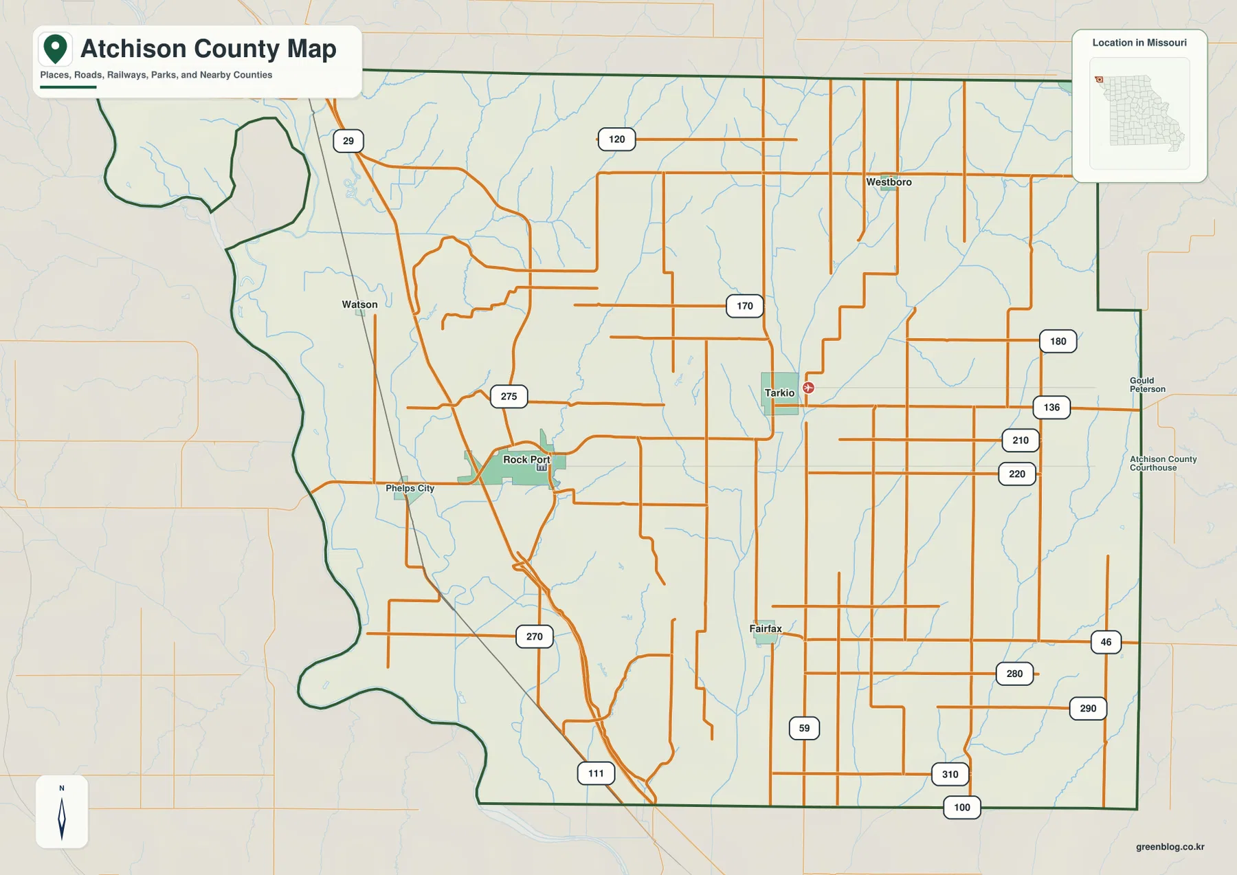
The western boundary bends with the Missouri River and older river channels, giving that side of the county an irregular outline. I-29 follows the low western side, while U.S. 59 crosses the higher interior farther east. The two north–south highways therefore occupy noticeably different landscapes. Because a static county map cannot show current construction, closures, flooding, or seasonal access limits, live travel conditions should be checked separately.
Atchison County Development Corporation describes Tarkio as being at the intersection of Highway 59 and Highway 136, about seven miles from I-29. Its local-government page identifies the Atchison County Courthouse in Rock Port. Together, those local sources match the two roles visible on the map: Tarkio as an interior crossroads and Rock Port as the county-government center with close interstate access.
Direct distances from Tarkio to Rock Port, Fairfax, Westboro, and Watson
The city-connections map uses Tarkio as the hub and lists four nearby communities. Its panel shows Tarkio at 1,471, Rock Port at 1,221, Fairfax at 702, Westboro at 106, and Watson at 51. These figures are the reference values printed on the supplied map and are best used for relative comparison; current official population figures should be checked in U.S. Census Bureau data when needed.
The distance labels are straight-line measurements rather than driving mileage. Rock Port is shown about 8 miles from Tarkio, Fairfax about 7 miles, Westboro about 7 miles, and Watson about 13 miles. Actual road distance can be longer because travelers may need to follow U.S. 59, U.S. 136, I-29 connections, county roads, or river-crossing approaches instead of a direct line.
Rock Port lies to the west-southwest of the Tarkio hub, Fairfax is to the south, Westboro is north, and Watson is much farther northwest near the river side of the county. The pattern reinforces Tarkio’s central position without implying that every route radiates directly from town. Returning to the general map after viewing the connection lines shows which highways actually serve the four destinations.
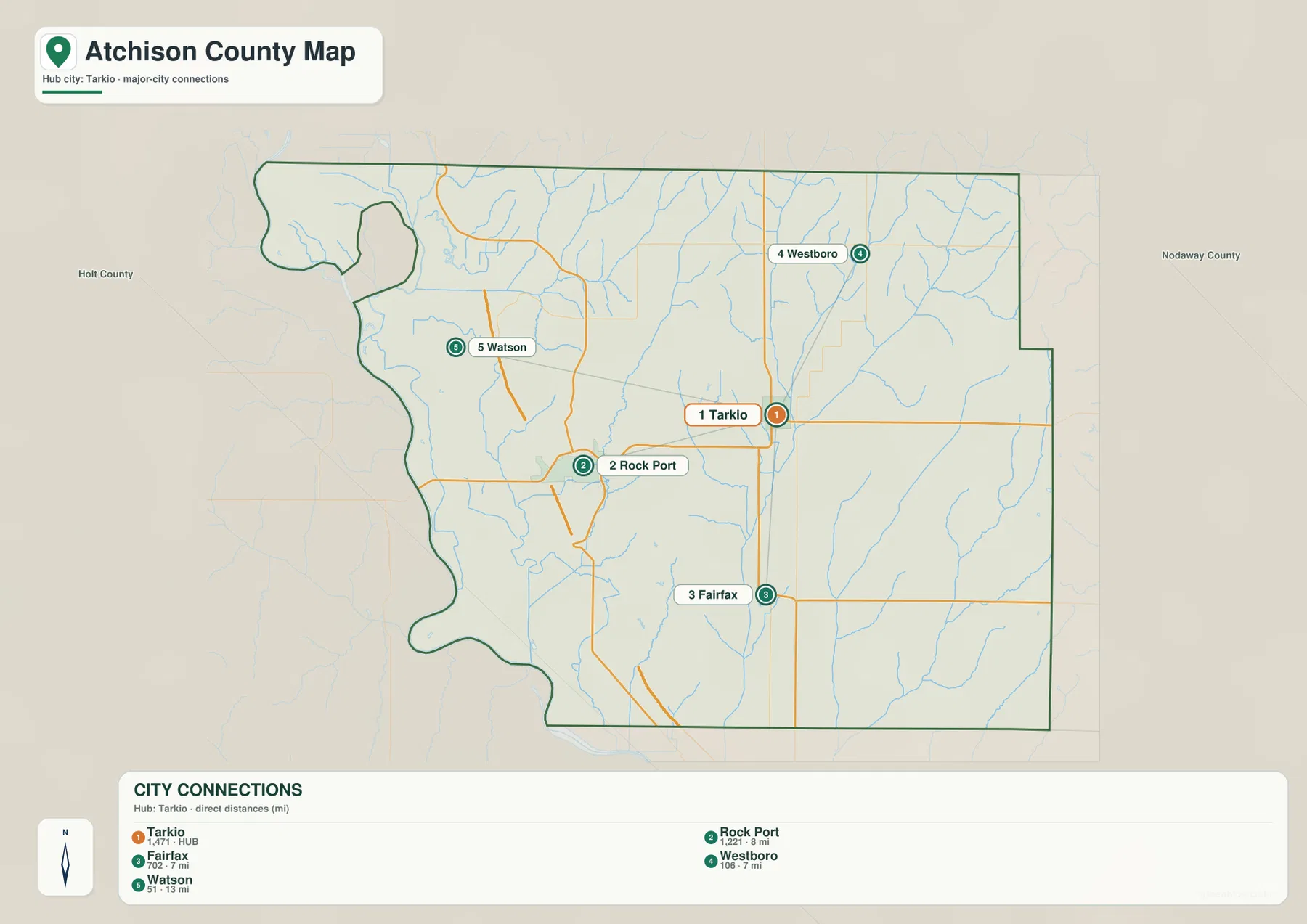
Tarkio and Rock Port are the two largest places in the connection panel, but their functions differ. Rock Port contains the county courthouse and has close I-29 access, while Tarkio sits at the U.S. 59 and U.S. 136 intersection. Fairfax provides the main southern point in the group. That combination of population scale, road access, and government function is more informative than a simple ranking by size.
Westboro and Watson also illustrate how much the physical setting changes within Atchison County. Westboro lies in the dissected interior near several creek valleys, while Watson is associated with the low Missouri–Nishnabotna river country. The simplified city map makes their spacing easy to see; the water and elevation views explain why the two places sit in such different landscapes.
Missouri and Nishnabotna river lowlands contrast with the Tarkio tributaries
The Missouri River is the dominant water feature on the western edge of Atchison County. In the northwest, the Nishnabotna River reaches the Missouri River area, and State Line Slough and an Old Channel Nishnabotna River are also labeled. The entire zone is broad and low compared with the interior, making Watson and the western county outline much easier to understand on the water map.
Missouri Department of Conservation describes the Nishnabotna Conservation Area as part of the Missouri River mitigation effort, with management for fish and wildlife habitat. The agency notes that the northern tract is accessed from the Missouri and Nishnabotna rivers and identifies Watson Access as the nearest river access. Those details fit the map’s concentration of river channels and low terrain around the northwestern corner.
Moving inland, Rock Creek runs through the west-central part of the county, while the Tarkio River forms a much longer north–south corridor farther east. Westboro Creek appears in the north-central area, and Middle Tarkio Creek descends from the northeast. These waterways occupy narrow valleys between higher ridges instead of the broad floodplain found beside the Missouri River.
The eastern side contains Little Tarkio Creek and East Fork Little Tarkio Creek, with Long Branch between parts of those systems. Taken together, the water map shows two very different patterns: one wide river-bottom zone in the west and a series of long, narrow stream valleys across the center and east. The elevation view repeats that contrast almost exactly.
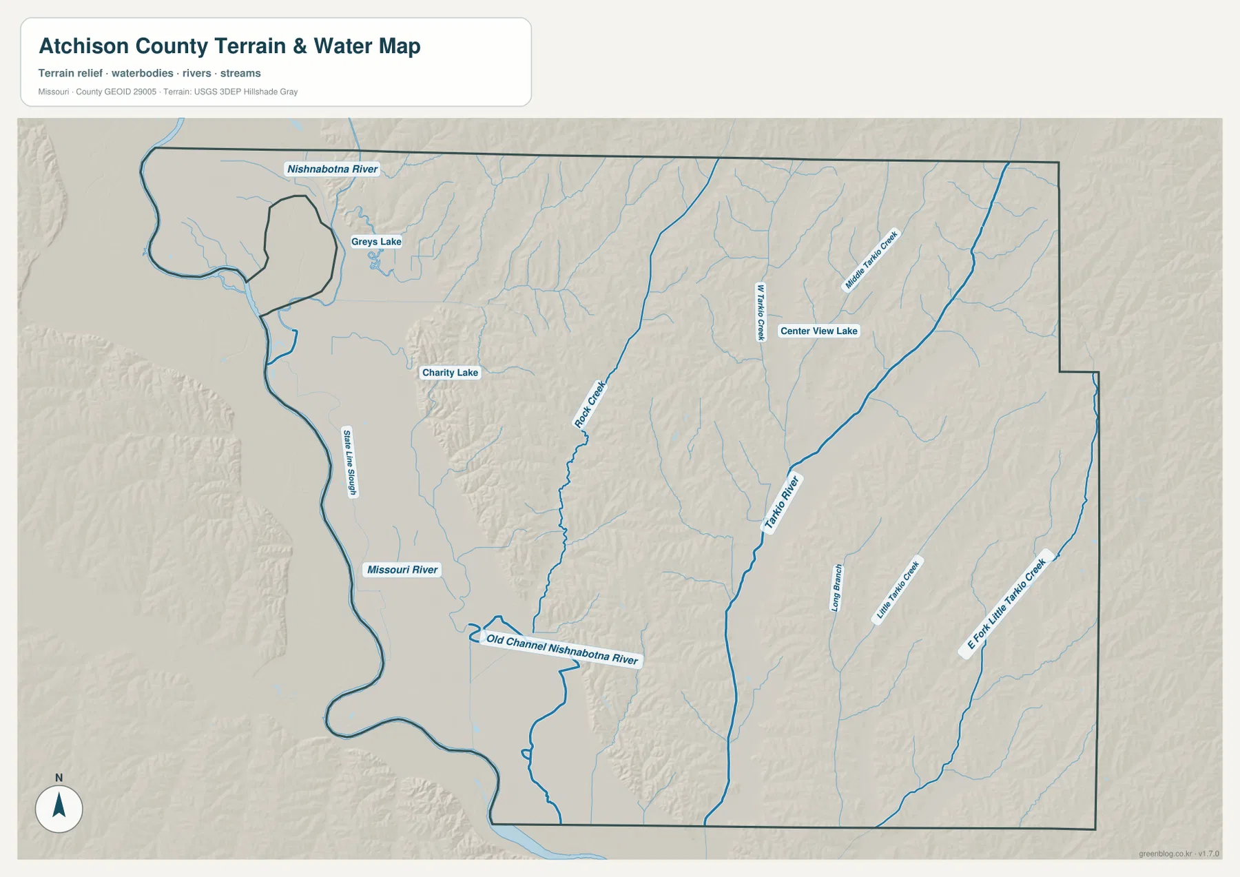
Several smaller water bodies help with local orientation. Greys Lake lies south of the Nishnabotna River in the northwest, Charity Lake is farther southeast, and Center View Lake appears between the Westboro Creek and Tarkio River areas. They are minor compared with the rivers but useful for matching the water view to the surrounding road and terrain maps.
Atchison County Development Corporation’s recreation page also lists Watson Access and the Nishnabotna Conservation Area as river-oriented recreation sites. This county-scale water image is intended to show where waterways lie, not to determine flood risk, water depth, water quality, legal channel boundaries, or boating conditions. Current official information should be used for safety and property decisions.
A 262–370 meter range separates the flat river plain from interior ridges
The elevation legend gives an actual range of about 262 to 370 meters with a mean near 304 meters. Dark green dominates the western Missouri River plain and the Nishnabotna confluence area. The floodplain is broad and almost featureless in the shaded relief, which makes the sudden rise into the interior especially easy to see.
East of Rock Port, the terrain climbs quickly into tan and brown ridges. Rock Creek and its smaller tributaries occupy lower green corridors between the uplands. This short-distance change from flat river bottom to dissected higher ground is one of the strongest geographic contrasts in the county and helps explain why roads near the western bluffs do not always follow simple straight lines.
The Tarkio River valley is another major low corridor. It runs north–south through the east-central part of the county, with elevated ridges on both sides. Westboro Creek and Middle Tarkio Creek divide those ridges further, creating a tightly textured landscape around Tarkio and Westboro. Comparing the road map with this surface makes the placement of towns and highway bends much easier to understand.
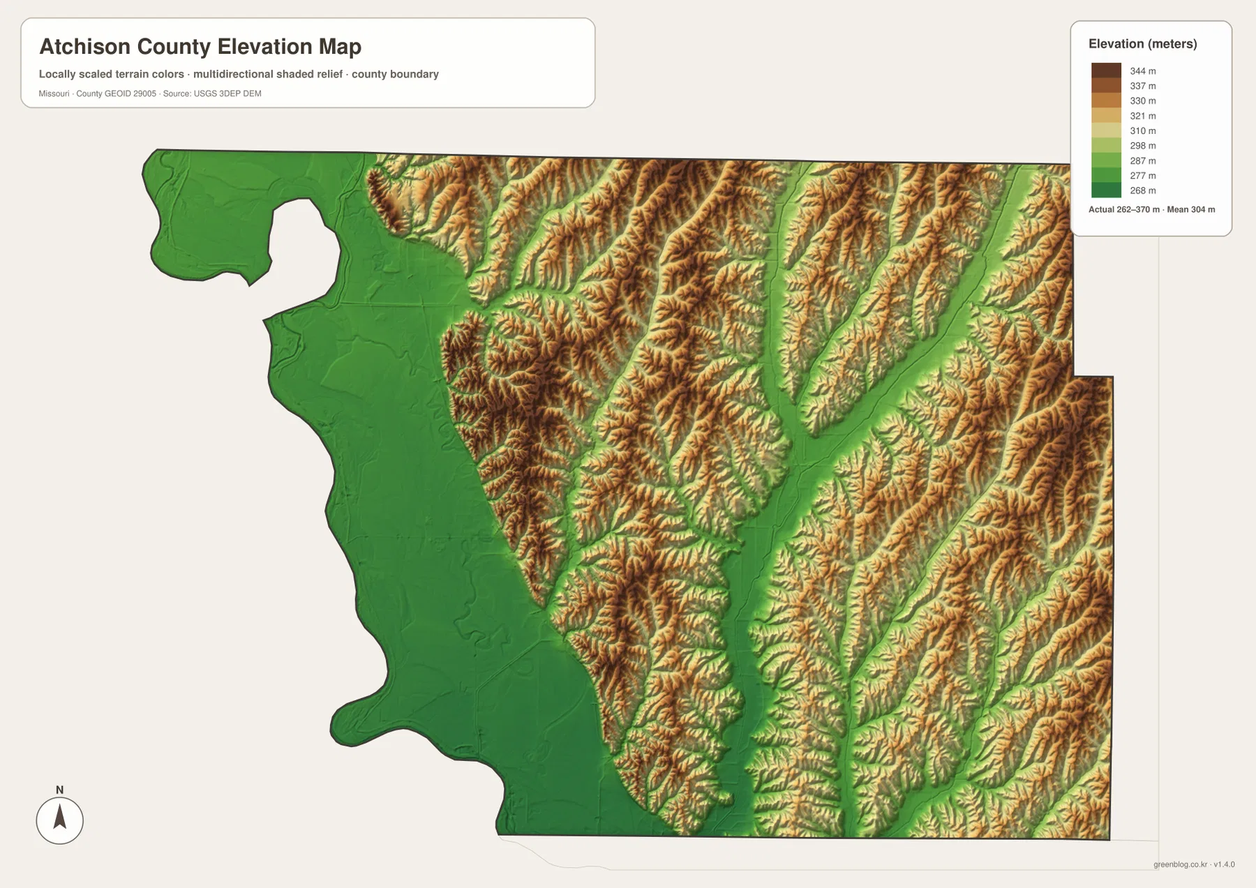
Farther east, Little Tarkio Creek and East Fork Little Tarkio Creek form additional green corridors through the uplands. The county therefore does not simply rise smoothly from west to east. A broad low plain occupies the far west, followed by a more complex interior where high ridges and lower stream valleys alternate repeatedly.
This elevation surface is generalized for county-scale comparison. It is not suitable for determining an exact parcel elevation, levee height, road grade, building site, drainage structure, or engineering design. Those tasks require source elevation data and field verification. For general readers, the map is most useful for comparing the Watson–Rock Port river plain with the Tarkio–Westboro ridge country.
A simple sequence for reading all four Atchison County views
Begin with Tarkio and locate the U.S. 59–U.S. 136 intersection. Then move west toward Rock Port and I-29, south on U.S. 59 toward Fairfax, and north toward Westboro. Watson should be placed much farther northwest beside the Missouri–Nishnabotna river country. With those five communities fixed, the county’s main road framework becomes straightforward.
Next, start the water view at the Missouri River and find the Nishnabotna confluence near the northwest. Move east through Rock Creek, the Tarkio River, and the Little Tarkio Creek systems. On the elevation image, the same sequence shifts from a broad green plain to brown ridges separated by green valleys, showing how closely water and terrain are connected.
Use the general map for highways, small towns, and the county boundary. The city-connections map is best for comparing direct distances from Tarkio. Choose the water map for Missouri, Nishnabotna, Tarkio, and the smaller creeks, and use the elevation map to see the contrast between the 262-meter river lowlands and the higher interior. Selecting the view that matches the task keeps the maps clear for printing, classwork, presentations, or personal reference.
Frequently Asked Questions
Is Tarkio the county seat of Atchison County?
No. The city-connections map uses Tarkio as its hub, but the Atchison County Courthouse is in Rock Port. Tarkio is the U.S. 59–U.S. 136 road crossroads, while Rock Port is the county-government center and is closer to I-29.
Are the distances from Tarkio road miles?
No. The map shows straight-line distances: about 8 miles to Rock Port, 7 miles to Fairfax, 7 miles to Westboro, and 13 miles to Watson. Actual driving mileage can be longer depending on U.S. 59, U.S. 136, I-29 connections, county roads, and river-side access.
Where is the lowest terrain in Atchison County?
The lowest land on the elevation map follows the Missouri River and Nishnabotna River in the west and northwest. The legend reports an actual range of about 262 to 370 meters with a mean near 304 meters. Farther inland, higher ridges are repeatedly cut by Tarkio River and creek valleys.
Map File Information
The ZIP contains the high-resolution JPG originals of the Atchison County general map, city-connections map, water map, and elevation map shown on this page.
- Included Files: 4 high-resolution JPG maps
Related Maps
Sources and references
- Atchison County Development Corporation — Local Government — courthouse location in Rock Port and local-government contacts
- Atchison County Development Corporation — Tarkio — local information on Tarkio and the U.S. 59/U.S. 136 crossroads
- Missouri Department of Conservation — Nishnabotna Conservation Area — Missouri–Nishnabotna river habitat and Watson Access information
- U.S. Census Bureau TIGER/Line Shapefiles — county boundaries and geographic reference data
- USGS National Hydrography — rivers, streams, and water features
- USGS 3D Elevation Program — elevation and terrain reference data
Green Map creates custom-edited map images using open geographic data sources such as geoBoundaries, Natural Earth, OpenStreetMap, and government open data. These maps are edited visual materials, not raw data files, and are provided for education, documents, presentations, and graphic reference.