Stokes County sits on North Carolina’s northern edge, where a small county seat, a stronger southern town pattern, and a rugged central landscape all compete for attention on the map. Danbury is the administrative center near the middle, but King is much more prominent in the southwest and Walnut Cove forms another distinct town area in the southeast. The northern half quickly becomes less urban, with winding roads, dense stream lines, and stronger relief.
This page uses three map views because each reveals a different part of the county. The general map is best for roads and place labels, the city-connections map uses King as a hub for comparing Danbury and Walnut Cove, and the terrain-and-water map shows the Dan River, the Little Yadkin system, lakes, creeks, and mountain relief. The matching high-resolution A3 JPG files are available together in the ZIP download box below; the WebP images are intended for quick viewing in the article.
Table of Contents
Stokes County quick facts
- County seat: Danbury
- Major visible place references: Danbury, King, Walnut Cove, Pinnacle, Germanton
- Road numbers visible on the general map include 8, 52, 65, 66, 89, 268, 704, 770, 772, and 311
- City-connections graphic: King as the hub, with Danbury about 13 miles and Walnut Cove about 13 miles away by straight-line distance
- Named water references include Dan River, Big Dan Lake, Little Yadkin River, East Prong Little Yadkin River, West Prong Little Yadkin River, and Peters Creek
- Existing page background: Hanging Rock and the Sauratown Mountains are important central-landscape references even though the county seat itself is small
The existing source material in the package states that Stokes County was formed from Surry County in 1789 and uses the Dan River and the Sauratown mountain area as major geographic references. This rewrite keeps that county-specific background while grounding the detailed discussion in the roads, settlements, rivers, lakes, and terrain visible in the supplied maps.
Danbury is the county seat, but King and Walnut Cove dominate the southern settlement pattern
Danbury appears near the middle of the general map, yet its developed area is very small. King occupies a much broader area along the southwest edge, and Walnut Cove forms another separate center in the southeast. That difference matters because county-seat status does not make Danbury the largest settlement. The map is easier to understand when administration and settlement size are treated as separate questions.
The road network reinforces those differences. Route 8 runs through the Danbury area and provides a strong north-south reference. Near King, routes 52 and 66 stand out. Route 65 passes through the Walnut Cove side toward Germanton, while 311 and 772 appear closer to the eastern edge. Routes 704 and 770 provide northeastern references, and 89 plus 268 help organize the west.
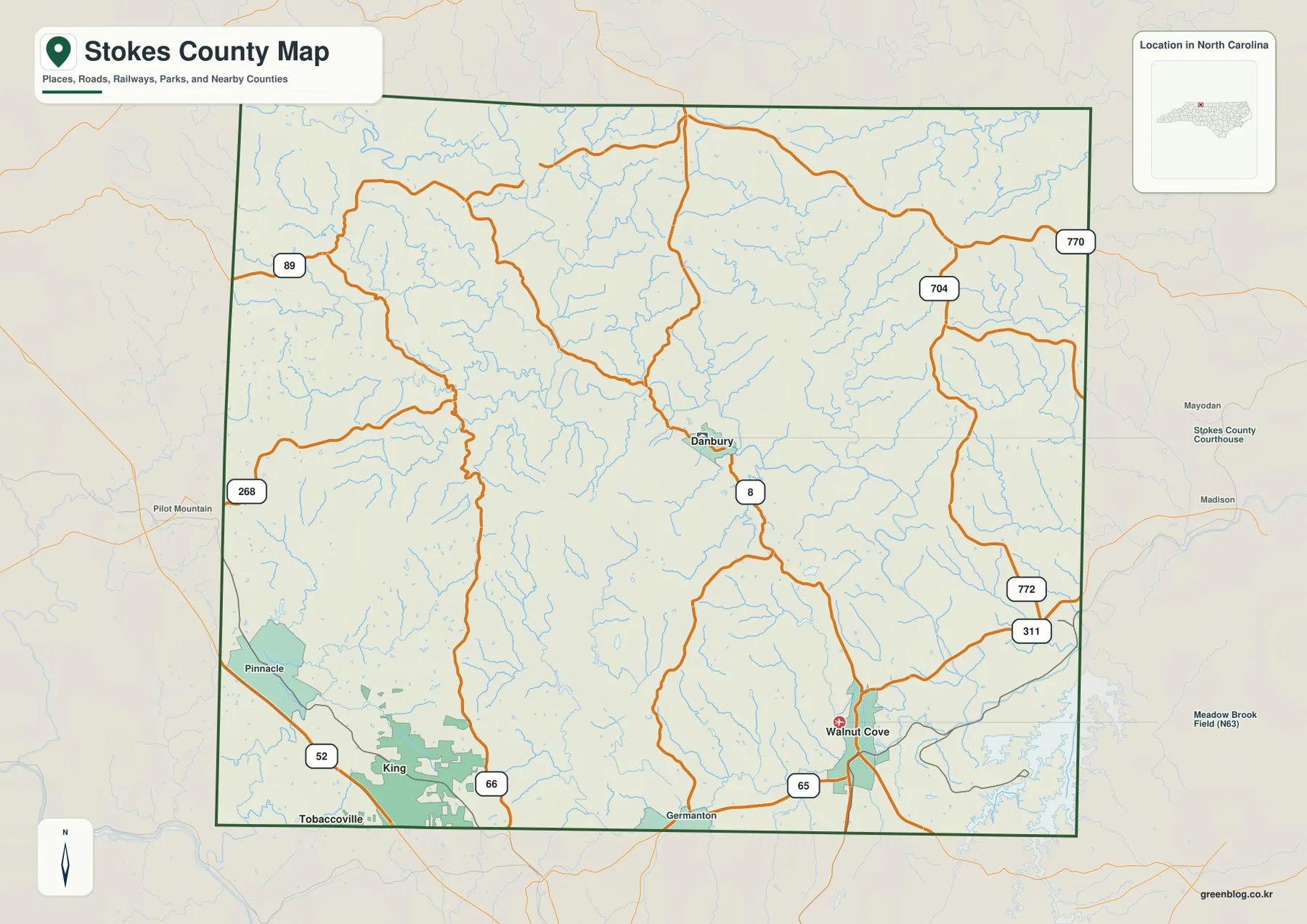
Pinnacle sits west of the central mountain area and north of King, with route 268 providing a useful nearby reference. Germanton appears along the southern edge between the King and Walnut Cove directions. Outside the county, labels such as Pilot Mountain, Mayodan, and Madison provide regional orientation, but they should not be confused with Stokes County communities.
The northern half looks much less urban than the south. Road lines bend through the interior, settlement labels become sparse, and the stream network becomes more prominent. Even before the terrain map is opened, this contrast suggests that the central and northern county should not be described using the same urban frame as King or Walnut Cove.
Dan River and the Little Yadkin system divide the mountain-and-foothill landscape
Dan River is the clearest named large river on the terrain-and-water map, crossing the central-eastern part of Stokes County. Big Dan Lake appears in the northwest, Peters Creek runs through the northern interior, and Crooked Creek is labeled in the northeast. These waterways occupy valleys that are much easier to recognize when the relief shading is visible.
The southwest belongs to a different water pattern. Little Yadkin River is labeled near the lower-left part of the county, with West Prong Little Yadkin River and East Prong Little Yadkin River feeding the same broader system. S Double Creek is also visible farther west. This makes it clear that not every Stokes County stream belongs to one simple Dan River corridor.
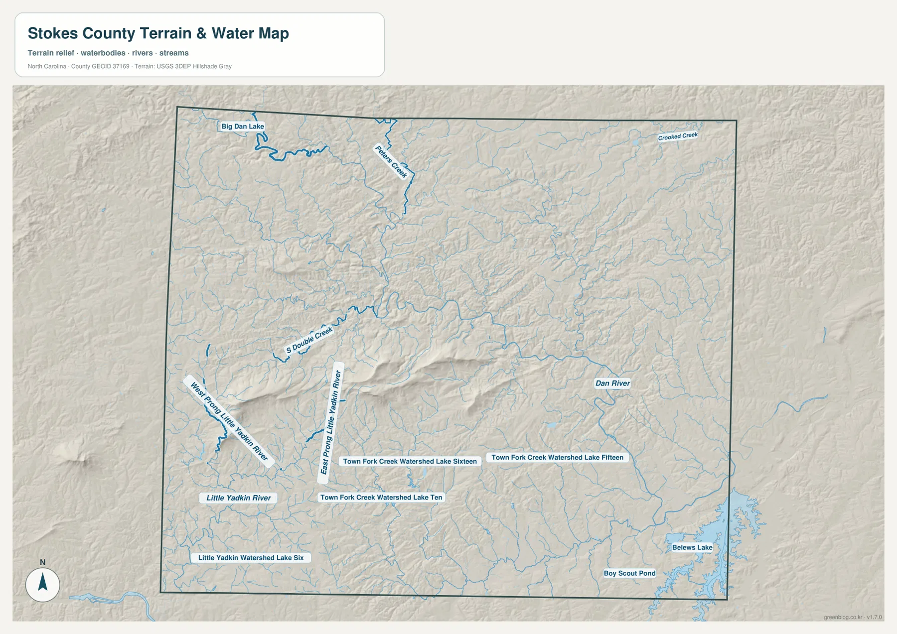
Several smaller water bodies help locate individual valleys. Town Fork Creek Watershed Lakes Ten, Fifteen, and Sixteen appear south of the central ridge area, while Little Yadkin Watershed Lake Six is farther southwest. Belews Lake reaches the southeastern edge and Boy Scout Pond is labeled just west of it. These names are useful local references rather than a list of major recreational lakes.
Relief shading is noticeably rougher through the middle of the county than around the southern towns. The existing Stokes County page connects this central high ground with Hanging Rock and the Sauratown Mountains, and the supplied terrain image supports the broader contrast between a rugged central zone and gentler southern edges. The map is still a general terrain reference, not a flood-hazard, parcel, depth, or engineering-elevation product.
King as a hub makes the small scale of Danbury immediately visible
The city-connections map simplifies the county to three marked places. Its lower panel lists King at 7,408, Walnut Cove at 2,115, and Danbury at 197. These are values printed on the supplied graphic; this article does not present them as independently updated population estimates.
The same graphic shows both Walnut Cove and Danbury about 13 miles from King. Those are straight-line distances, not road mileage or travel time. Actual driving routes can differ because of the road network and terrain, so the general map should be used whenever a route or journey is the question.
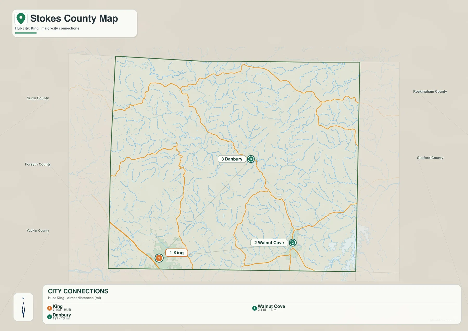
The two 13-mile connections point in different directions. Walnut Cove lies east of King near the southern edge, while Danbury is well to the north in the central mountain area. King therefore anchors the southwest, Walnut Cove the southeast, and Danbury the administrative middle. Treating them as one continuous town corridor would remove the most useful geographic difference shown by the map.
The outer labels identify Surry, Forsyth, Yadkin, Rockingham, and Guilford counties. They help position Stokes County within northern North Carolina but do not turn the city graphic into a legal boundary or adjacency survey. The marked Stokes County points and the county outline remain the primary references.
Switching between mountain, river, and southern-road references keeps the county readable
A Danbury-only description makes Stokes County look more centralized than the maps suggest. Danbury is the right reference for county administration, but King and Walnut Cove explain the stronger southern settlement pattern. When the question shifts to the physical landscape, Dan River and the central relief become more useful than any town name.
The southwest combines King and Pinnacle with the Little Yadkin drainage. The southeast combines Walnut Cove and Germanton with the Belews Lake side. The central and northern county are better described through Danbury, Dan River, Peters Creek, winding roads, and the rougher ridge-and-valley terrain. Changing the reference point by area produces a much more faithful map description.
Use the general map when numbered roads and settlements need to be seen together. Use the city-connections map for the simple King-Danbury-Walnut Cove comparison and the two 13-mile straight-line links. Use the terrain-and-water map when the question involves Dan River, the Little Yadkin branches, lakes, creek valleys, or the stronger central relief.
The download archive contains three high-resolution A3 JPG files matching the Stokes County general map, city-connections map, and terrain-and-water map. The WebP versions are convenient for on-page browsing, while the JPG originals are better for printing, enlargement, and document use. Legal boundary decisions, surveying, flood determinations, or engineering-grade elevation work should rely on the appropriate Census, USGS, or county source data rather than these general reference maps.
Frequently Asked Questions
Why does Danbury look so small even though it is the county seat?
County-seat status describes an administrative role rather than settlement size. The supplied city graphic lists King at 7,408, Walnut Cove at 2,115, and Danbury at 197, so the map clearly separates Danbury’s administrative importance from the larger southern settlement centers.
What does the Dan River show that the town map does not?
Dan River gives the central and eastern county a physical reference that is independent of settlement size. Combined with the Little Yadkin system in the southwest and the stronger central relief, it shows that Stokes County contains more than one drainage and terrain setting.
Map File Information
The ZIP contains three high-resolution A3 JPG files matching the Stokes County general map, city-connections map, and terrain-and-water map shown on this page.
- Included Files: Use only the versions confirmed in the article and supplied images
- File Type: Use the confirmed download contents
- Intended Use: Printing, education, presentations, and map-based projects
Related Maps
Sources
- NCpedia – Stokes County
- U.S. Census Bureau – TIGER/Line Shapefiles
- USGS – National Hydrography
- USGS – 3D Elevation Program
For this Stokes County page, the source set provides county background plus boundary, road, water, and elevation references. The settlement values, straight-line distances, road labels, and water names described above come from the supplied Stokes County package, while the county source is used only for background not printed directly on the preview maps.
Green Map creates custom-edited map images using open geographic data sources such as geoBoundaries, Natural Earth, OpenStreetMap, and government open data.
These maps are edited visual materials, not raw data files, and are provided for education, documents, presentations, and graphic reference.