Irion County in west-central Texas is a place where distance matters. Mertzon is the main community shown on the city map, while the broader county map spreads roads, ranch country, small named places, creeks, and draws across a large area. The four maps on this page let you compare county roads and settlements, Mertzon’s role within the county, the Middle Concho River drainage, and an elevation range of roughly 606 to 837 meters. After reviewing the web images, you can download a ZIP containing the same four maps as high-resolution A3 JPG files.
The maps are most useful when read together rather than as four isolated pictures. The county map places Mertzon in the eastern half of the county and Barnhart in the southwest, with Arden and Old Freitag Place farther north. The city map simplifies that pattern by highlighting Mertzon as the principal city in its index. The terrain-and-water map shows the Middle Concho River crossing the northern part of the county, while the elevation map reveals higher ground toward the west and southwest and lower terrain toward the east. Those differences explain why a county that looks open and lightly settled can still contain a varied landscape.
Table of Contents
Mertzon as the Road Reference Point Across a Wide County
The general county map gives the clearest overview of how places and roads fit together. Mertzon sits east of the county’s center and is surrounded by several numbered roads, while Barnhart lies well to the southwest. Arden appears in the northeastern part of the map and Old Freitag Place is shown farther northwest. The large spaces between these labels are important: Irion County is not a continuous chain of towns, so the road network has to connect small communities and rural land across long stretches. For orientation, it is usually more helpful to follow a road from Mertzon toward the next named place than to look only at the county boundary.
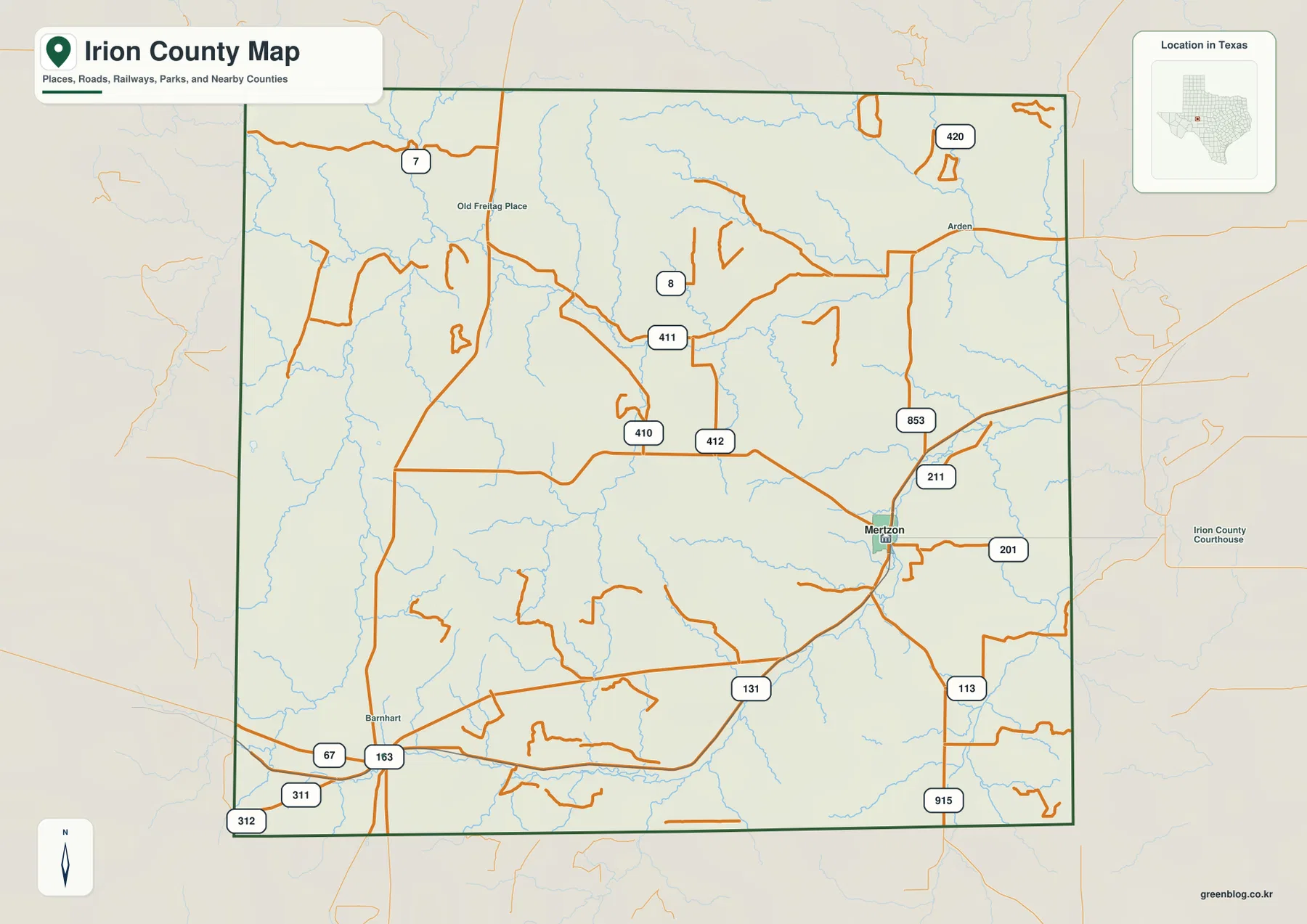
U.S. 67 is the most recognizable through route on the map, linking the Barnhart side of the county with Mertzon and continuing toward larger regional destinations. Around Mertzon, additional numbered routes fan out in several directions, including roads labeled 201, 211, and 853. Farther north and west, routes such as 410, 411, and 412 connect rural areas that have few settlement labels. The value of this map is not in memorizing every number. It is in seeing where roads converge, where they continue across open land, and how far apart Mertzon, Barnhart, Arden, and the other named locations are from one another.
Why the City Map Puts Mertzon Alone in the Major-City Index
The city map is deliberately simple. It identifies Mertzon as the county’s single major city in the displayed index, with a population label of 764 on this map. That number should be treated as the value used by the map dataset rather than a live population counter, but the map still makes an important point: Irion County does not have several similarly sized urban centers competing for attention. Mertzon is the obvious local reference point and is also identified in the existing county material as the county seat. That makes it the most practical place to start when locating services, roads, and nearby rural areas.
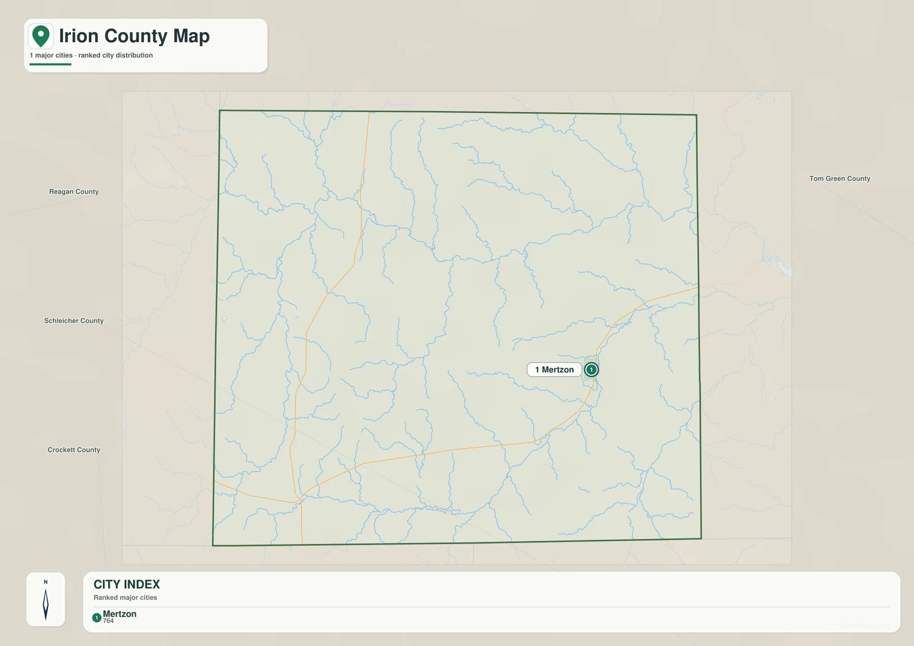
The same map also places neighboring counties around Irion County, including Reagan County to the west, Tom Green County to the east, and Schleicher and Crockett counties to the south and southwest. These labels are useful because they show that Mertzon is closer to the eastern side of the county than to the broad western ranch country. Travel toward Tom Green County leads into the San Angelo side of the region, while the western and southwestern directions remain much more lightly settled. For someone comparing county maps, this context helps explain why Mertzon can function as the local administrative center even though much of the county around it has a very different rural character.
Middle Concho River, Creeks, and Draws Across the Landscape
The terrain-and-water map changes the emphasis from roads to drainage. The Middle Concho River is the strongest named watercourse, running across the northern portion of the county from west toward east. Middle Concho Creek joins that system from the west, while West Rocky Creek and Dry Creek appear farther north and northeast. South of the river, the map labels a broad collection of smaller streams and draws, including Lopez Creek, Spring Creek, Dove Creek, Tee Pee Draw, and Dutchwoman Draw. The result is a network of narrow valleys rather than a landscape organized around one large lake.
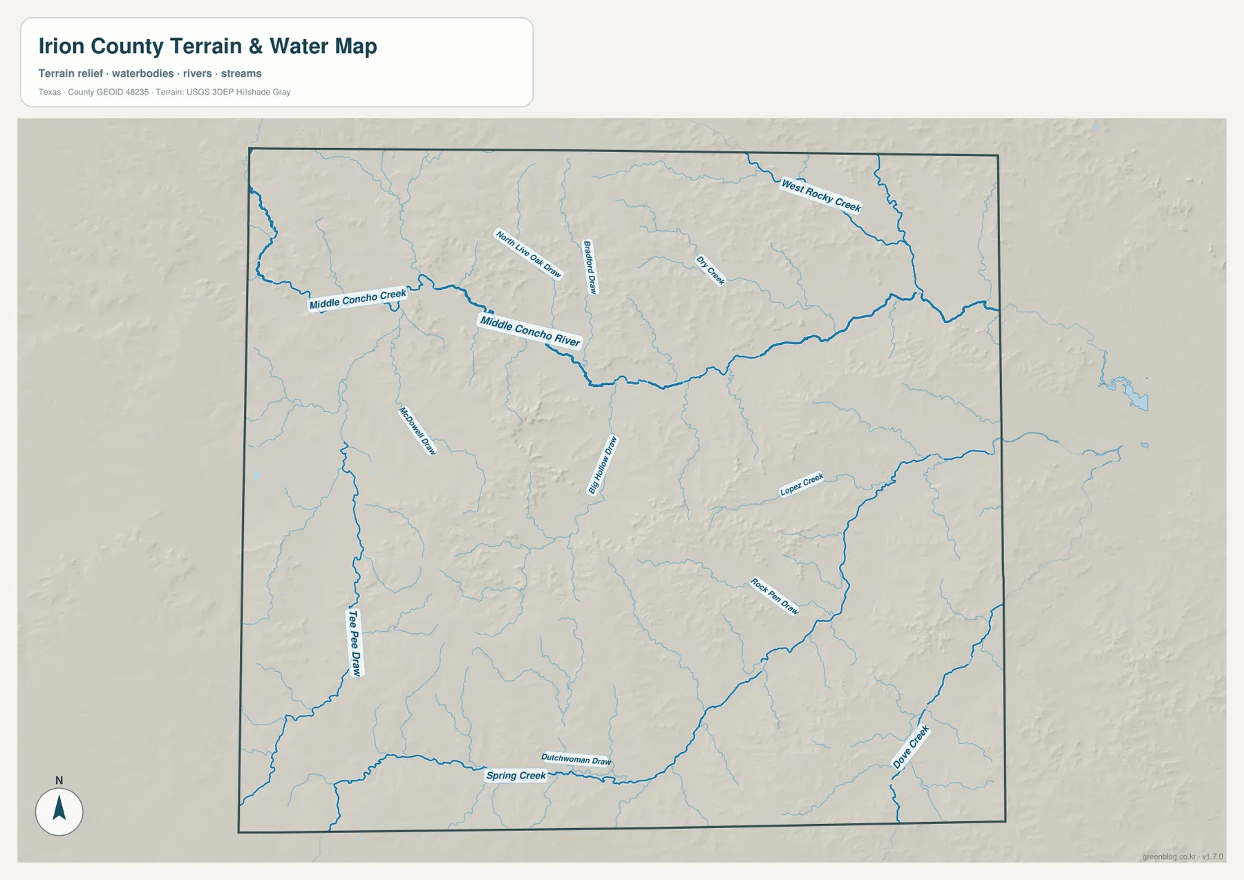
Several of these features are easy to miss on a road-focused map. Spring Creek runs for a long distance across the southern part of the county, while Dove Creek follows the southeast side and Lopez Creek lies farther north. Tee Pee Draw is prominent along the western side, and other named draws cut through the central uplands. These lines do not mean that every channel carries water continuously. In a dry part of Texas, a draw may be a drainage feature that is most noticeable after rainfall. The map is therefore best used to understand where valleys and drainage routes are located, not as a statement about current streamflow or flood conditions.
From 606 to 837 Meters: Higher Western Ridges and Lower Eastern Ground
The elevation map gives Irion County a very different appearance from the pale road map. Its legend reports an actual elevation range of about 606 to 837 meters, with a mean close to 735 meters. Brown and tan areas mark the higher ground, which is most extensive in the west and southwest and also appears in several central ridges. Greener terrain spreads across much of the east and northeast, showing lower elevations. The difference of more than 200 meters is enough to create a clear contrast between uplands, narrow valleys, and the lower corridors followed by some streams.
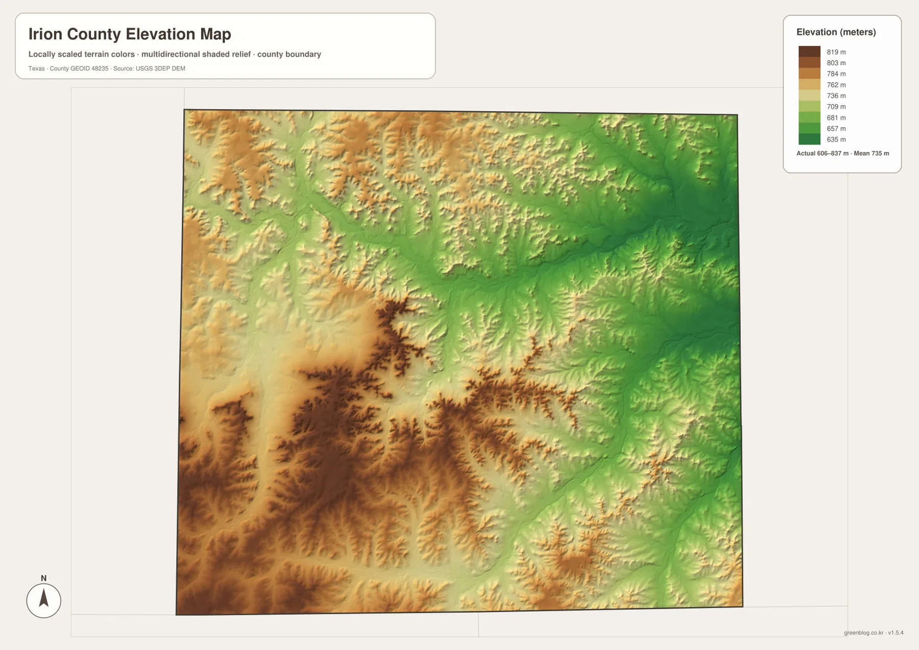
Comparing this image with the water map is especially useful. Lower green bands often line up with creek valleys and drainage routes, while the darker ridges separate one drainage area from another. The Middle Concho River corridor becomes easier to recognize when the two maps are viewed side by side, and the southern creek network can be traced through a series of lower cuts between higher ridges. The map is suitable for general terrain study, classroom use, trip planning, and county-to-county comparison, but it is not a substitute for survey-grade elevation data or engineering measurements.
A Practical Way to Compare Roads, Settlement, Water, and Relief
A good way to use the set is to choose one place and locate it on every map. Start with Mertzon on the county map and note the roads that approach it. Then use the city map to see how strongly Mertzon stands out from the rest of the county. On the water map, look north and west for the Middle Concho River system and the smaller creeks that cross the surrounding ranch country. Finally, use the elevation map to see whether those waterways occupy lower ground or cut between higher ridges. This simple sequence turns four separate maps into one connected picture of the county.
Barnhart produces a different comparison. It appears as a named place in the southwest on the county map but is not included in the major-city index. Nearby terrain is generally higher than the eastern side of the county, and the western water map shows Tee Pee Draw and smaller drainage lines crossing that broad area. That combination is useful when explaining the difference between a named rural community and the county’s main administrative center. It also shows why the city map should not be treated as a complete list of every settlement visible on the more detailed county map.
High-Resolution JPG Files for Printing and Reference
The WebP images in the article are designed for quick viewing in a browser. If you need larger files for printing, a classroom handout, a county comparison project, or offline reference, use the downloadable JPG archive. The ZIP contains the county map, city map, terrain-and-water map, and elevation map as separate high-resolution images. Each JPG is approximately 3638 by 2572 pixels, preserving much more detail in the road numbers, stream labels, and shaded relief than a small on-screen preview can show.
The general map is the best starting point for roads and named places, the city map is the quickest reference for Mertzon’s role, the water map is suited to river and creek locations, and the elevation map is the clearest choice for broad height differences. You do not have to use all four for every task. Choosing the version that matches the question keeps the map readable and avoids adding information that is not needed.
Frequently Asked Questions
What is the easiest reference point to find first in Irion County?
Mertzon is the best starting point. It is the only major city highlighted on the city map, it is identified in the existing county material as the county seat, and several roads meet around it on the general map. Once Mertzon is located, Barnhart to the southwest and the Middle Concho River to the north provide two useful secondary reference points.
Where does the Middle Concho River appear on the map?
The terrain-and-water map shows the Middle Concho River crossing the northern part of Irion County from west toward east. Middle Concho Creek joins the system from the west, and several smaller creeks and draws branch through the surrounding terrain. Comparing the river with the elevation map also shows that much of the drainage follows lower ground between higher ridges.
How much elevation variation is shown within Irion County?
The elevation map reports an actual range of approximately 606 to 837 meters and a mean elevation of about 735 meters. Higher terrain is concentrated mainly in the west and southwest, while lower green areas are more common toward the east. That range makes the county’s ridges and stream valleys much easier to see than on a road-only map.
Sources and Reference Data
For official boundary and road data, see the U.S. Census Bureau TIGER/Line Shapefiles. River, creek, and drainage information can be checked against USGS National Hydrography. Elevation data and program details are available from the USGS 3D Elevation Program, and the USGS The National Map Viewer provides a convenient way to compare several geographic layers in one place.
Map File Information
Download the Irion County road, city, water, and elevation maps together as high-resolution JPG files.
- File Type: ZIP containing JPG images
Related Maps
- Reagan County Texas map
- Schleicher County Texas map
- Sterling County Texas map
- Tom Green County Texas map
- Pecos County Texas map
Green Map creates custom-edited map images using open geographic data sources such as geoBoundaries, Natural Earth, OpenStreetMap, and government open data.
These maps are edited visual materials, not raw data files, and are provided for education, documents, presentations, and graphic reference.