Coconino County stretches across a large part of northern Arizona, and the supplied maps make its internal distances immediately apparent. Flagstaff and Williams sit relatively close together in the south-central part of the county along Interstate 40, while Grand Canyon Village and Tusayan lie farther north and west. Page and Fredonia are far up near the northern edge, so a single county boundary contains communities that are separated by very different landscapes and long distances.
This page explains the county boundary, major roads, selected communities, rivers and lakes, and elevation changes shown in the four provided maps. The maps are useful for different questions: the road map is best for orientation, the city-connection map makes the size of the county easier to grasp, the terrain and water map emphasizes the Colorado River system, and the elevation map shows how sharply high plateaus and deeply cut canyon country differ. High-resolution JPG versions of the same maps are available in the download box later on the page.
Table of Contents
A county that runs from the Flagstaff corridor to Page and Fredonia
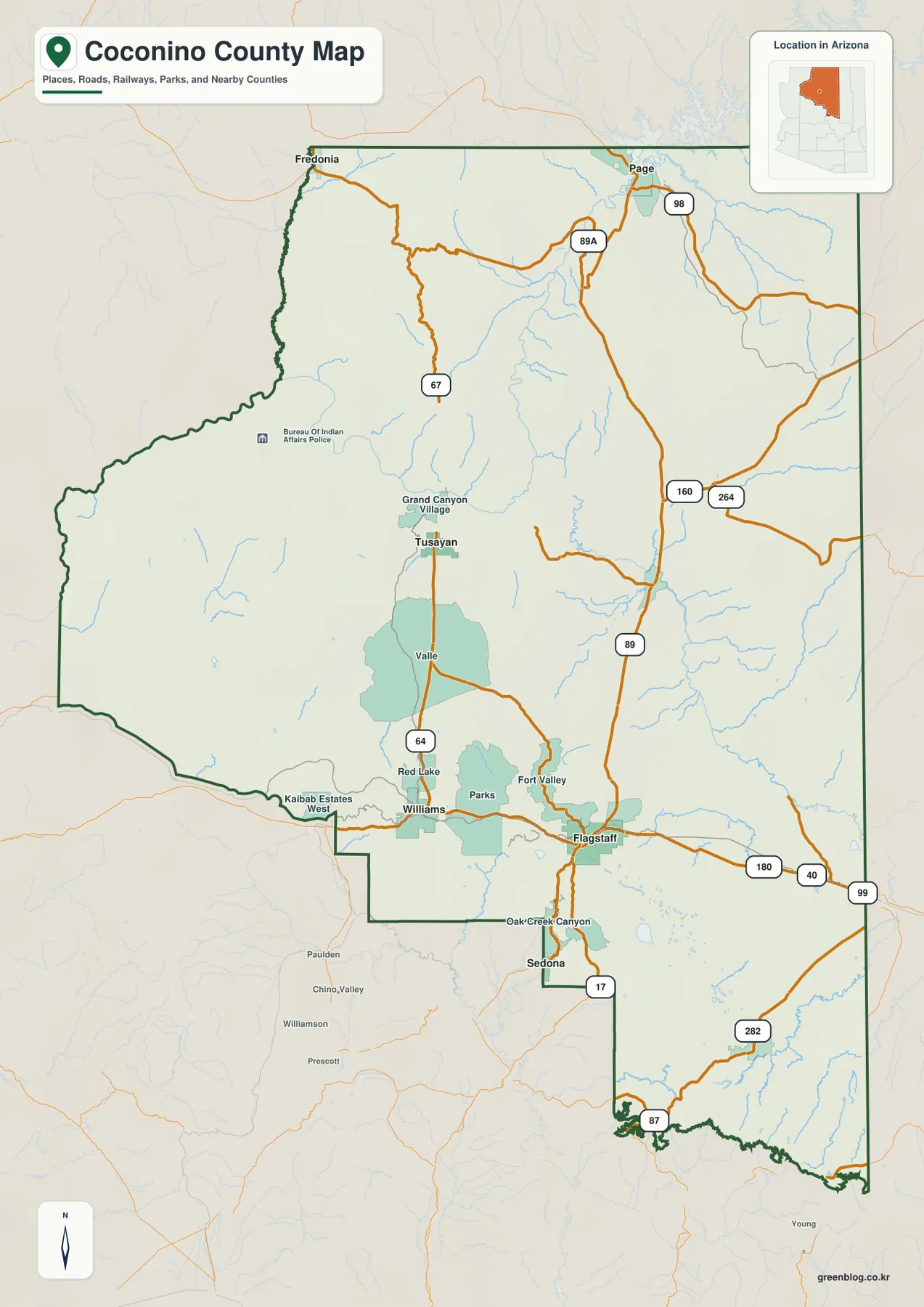
The general county map gives the clearest first look at how Coconino County is organized. Flagstaff and Williams are the most prominent places in the southern part of the map, linked by I-40. Parks, Fort Valley, Red Lake, and Kaibab Estates West appear nearby, while I-17 leaves Flagstaff toward the south. US 89 heads north from the Flagstaff area toward Page, and AZ 64 runs through Williams and Valle toward the Grand Canyon area. These routes make the southern half of the county easier to understand before looking at the much more widely separated communities to the north.
Grand Canyon Village and Tusayan occupy a separate cluster west of the county’s central line, well north of Williams and Flagstaff. Page is near the northeastern end of the county, while Fredonia is near the opposite side of the northern boundary. Roads such as US 89 and 89A cross large stretches of open country between these areas, and the map scale makes it obvious that the northern communities are not simply suburbs of Flagstaff. The long north-south span is one of the most important facts to keep in mind when using any Coconino County map.
The county outline is also distinctive. Instead of ending in a simple straight southern edge, it steps southward around the Oak Creek Canyon and Sedona area before narrowing toward the lower part of the map. In the north and west, the boundary follows a much broader sweep around canyon and plateau country. That irregular shape matters when comparing nearby places because a town that looks close on a regional Arizona map may sit outside the county or require a route that follows a limited number of major highways.
Flagstaff is close to Williams but far from the northern communities
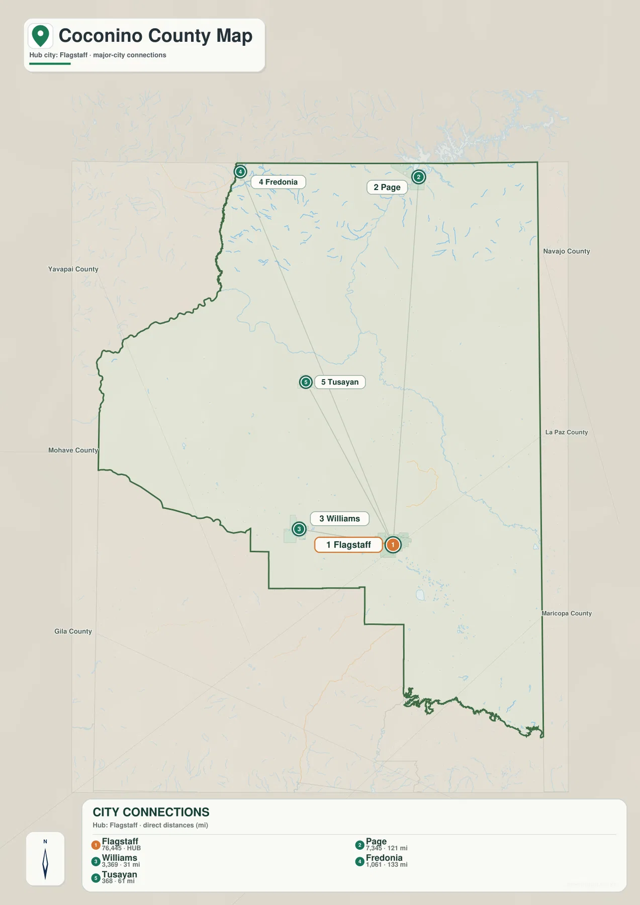
The city-connection map turns the county’s large scale into a set of easy comparisons. Flagstaff is the hub. Williams is shown about 31 miles away, and Tusayan about 61 miles away. Page is much farther at roughly 121 miles, while Fredonia is about 133 miles from Flagstaff. Those figures are straight-line distances between mapped points, not driving distances along the highway network, so they should not be used as estimates of trip length or travel time.
The directions are just as informative as the numbers. Williams is west of Flagstaff, and Tusayan sits farther north toward Grand Canyon country. Page lies near the northeastern side of the county, while Fredonia is at the far northwestern side. From Flagstaff, that creates several very different travel directions rather than a single string of towns along one road. The comparison helps explain why a visitor heading to Page would use a different northern corridor from someone going to Williams or approaching the Grand Canyon through Tusayan.
This map intentionally focuses on a small set of major communities rather than every settlement. Its purpose is to show how far apart key places are across the county and how they sit relative to the Flagstaff hub. When paired with the general road map, it becomes easier to distinguish the compact Flagstaff-Williams area from the more distant Page and Fredonia endpoints. That distinction is especially important on a county as large and irregularly shaped as Coconino, where a simple list of place names does not convey the actual spacing.
The Colorado River cuts through a very different northern landscape
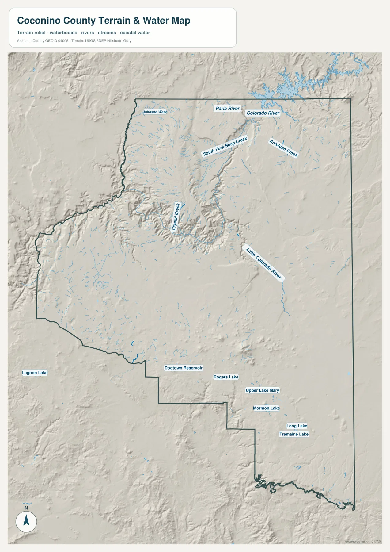
The terrain and water map changes the emphasis from highways to valleys, plateaus, rivers, and smaller drainage features. The Colorado River is the dominant waterway across the northern part of the map. The Paria River appears near the north, while the Little Colorado River approaches from the east. Smaller labeled features include Antelope Creek, South Fork Soap Creek, Crystal Creek, and Johnson Wash. Because the water lines are drawn over shaded relief, the map shows not only where the waterways are located but also how they relate to steeply cut terrain.
Around the Grand Canyon portion of the county, the river corridor sits far below the adjacent uplands. The shaded terrain makes this contrast much clearer than the road map does: a narrow, deeply incised route follows the Colorado River while higher surfaces rise on either side. The National Park Service describes Grand Canyon National Park as encompassing 278 miles of the Colorado River and adjacent uplands, which helps explain why the river and canyon topography are such central features when looking at this part of northern Arizona.
The southern half of the water map has a different character. Instead of one dominant river corridor, several lakes and reservoirs stand out. Upper Lake Mary and Mormon Lake are labeled southeast of the Flagstaff area, with Long Lake and Tremaine Lake farther east. Dogtown Reservoir appears near the Williams area, and Rogers Lake is shown southwest of Flagstaff. These features make the water map useful for basic geographic reference, but it is not a flood-risk map, a navigation chart, or a source of real-time water-level information.
Elevation changes from deep canyon country to high plateaus and mountains
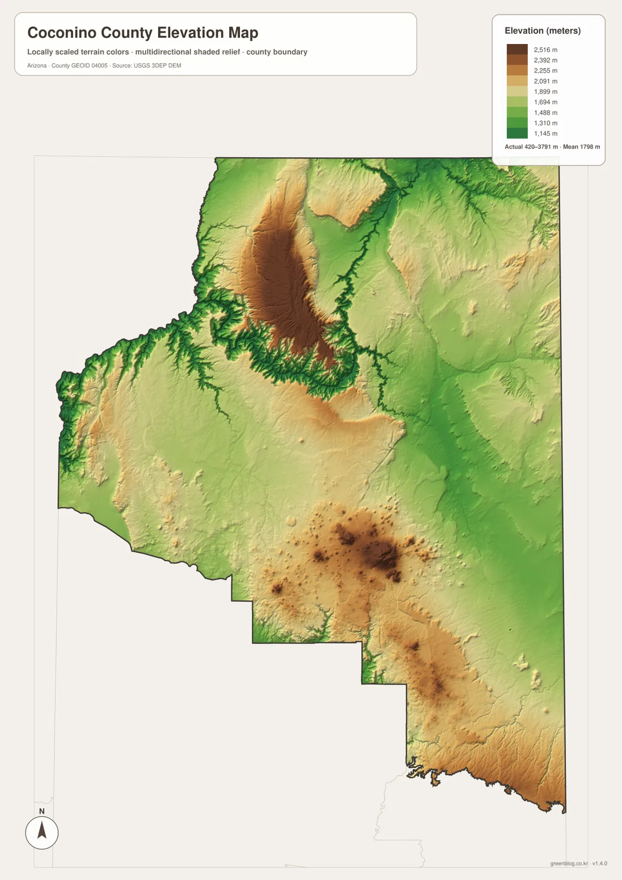
The elevation map makes the county’s vertical range explicit. Its legend notes an actual elevation range of about 420 to 3,791 meters, with a mean near 1,798 meters. The color scale is designed for regional comparison rather than surveying, so the most useful information is the contrast between large high areas and deeply cut low corridors. That contrast is especially dramatic in the northern half of the county, where high plateau surfaces sit next to the incised Colorado River canyon system.
In the north-central area, broad brown and tan highlands are bordered by lower green canyon terrain. Comparing this map with the water map shows that many of the lowest-looking linear areas follow major river and canyon corridors. Farther south, another concentration of high terrain stands around the Flagstaff region, while lower areas extend eastward and southeastward. The result is not a simple slope from north to south; instead, the county contains several high blocks separated by lower valleys, canyons, and broad lower surfaces.
This is why road distance alone does not describe travel or landscape in Coconino County. Two places may look reasonably close in plan view while steep canyon terrain or high plateau country lies between them. The elevation map is best for understanding that broad relief. It should not be treated as a parcel-level elevation source, a survey, or an engineering-grade surface, but it is well suited to comparing the Grand Canyon corridor, the Flagstaff high country, and the lower eastern parts of the county.
Choosing the map that matches the question
For roads, communities, and county orientation, start with the general county map. It shows the relationship among I-40, I-17, US 89, AZ 64, Flagstaff, Williams, Grand Canyon Village, Page, Fredonia, and other labeled places. If the main question is how far the larger communities are from Flagstaff, the city-connection map is faster because it removes most road detail and emphasizes direction and straight-line distance.
For physical geography, the terrain and water map is the better starting point. It connects the Colorado River and Little Colorado River with the shaded canyon landscape and also identifies several southern lakes and reservoirs. The elevation map then adds a second layer of understanding by showing how high the surrounding plateaus and mountain areas are relative to the deeply cut river corridors. Using the two together is more informative than trying to infer terrain from a highway map alone.
The downloadable files are useful when you need a larger version for printing, classroom work, presentations, or offline reference. The web images on this page are reduced for convenient viewing, while the ZIP contains the corresponding high-resolution JPG maps. These maps are general geographic references; changing road conditions, flood information, property boundaries, and precise survey elevations should always be checked with the appropriate current official source.
What to keep in mind when reading these maps
Coconino County covers enough territory that a small-scale map can make distant places seem deceptively close. It helps to begin with the full county outline, identify the Flagstaff-Williams cluster, then move north to Grand Canyon Village and Tusayan before locating Page and Fredonia at the top of the county. That sequence makes the long distances and different road corridors easier to understand. It also prevents the county’s many geographic features from becoming a simple list of unrelated names.
Each map also has a specific limitation. The city distances are straight-line measurements, not driving distances. The water map is a geographic reference, not a flood forecast or boating chart. The elevation map summarizes broad relief rather than providing survey-grade heights for a specific site. Used with those limits in mind, the set gives a clear introduction to how Coconino County’s communities, roads, waterways, and high-relief terrain fit together.
Frequently Asked Questions
How far are Page and Fredonia from Flagstaff on the city map?
The supplied city-connection map shows Page at about 121 miles and Fredonia at about 133 miles from Flagstaff. Those are straight-line distances between the mapped points, not highway driving distances, so an actual trip can be considerably different.
Which map best shows the Grand Canyon river corridor and elevation change?
Use the terrain and water map first to locate the Colorado River, Little Colorado River, and surrounding canyon relief. Then compare it with the elevation map, which makes the difference between the high plateaus and the deeply cut river corridor easier to see.
What files are included in the Coconino County download?
The ZIP contains high-resolution JPG versions of the county map, city-connection map, terrain and water map, and elevation map shown on this page. They are intended for general reference, printing, and document use.
Map File Information
The ZIP download contains high-resolution JPG maps for Coconino County covering the county boundary and roads, city connections, terrain and water, and elevation.
- Included Versions: County map, city-connection map, terrain and water map, elevation map
- File Type: JPG
Related Maps
Sources and References
- Coconino County Official Website – About Us
- U.S. National Park Service – Grand Canyon National Park
- U.S. Census Bureau – TIGER/Line Shapefiles
- USGS – National Hydrography
- USGS – 3D Elevation Program
Green Map creates custom-edited map images using open geographic data sources such as geoBoundaries, Natural Earth, OpenStreetMap, and government open data. These maps are edited visual materials, not raw data files, and are provided for education, documents, presentations, and graphic reference.