Davie County is easiest to recognize when Mocksville, Bermuda Run, Cooleemee, and the South Yadkin River are viewed together rather than as separate labels. Mocksville sits near the middle of the county and anchors several major roads, Bermuda Run occupies the northeast side close to the county edge, and Cooleemee lies much farther south near the river corridor. This Davie County Map page brings those places together with road, city, and water views, and the high-resolution A3 JPG files are available in one ZIP near the bottom of the article.
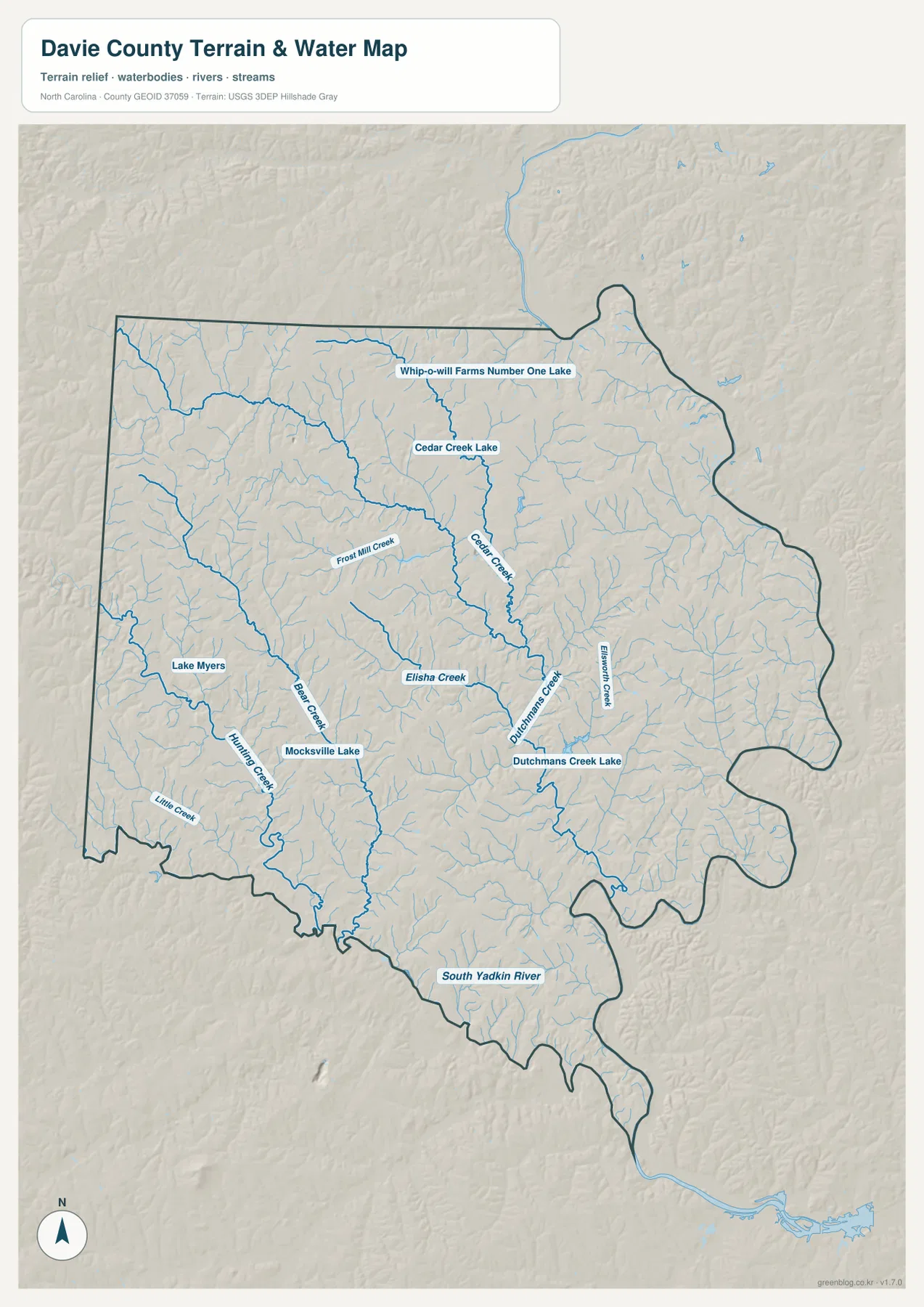
The three map views emphasize different details without changing the county itself. The county map is best for roads, places, and neighboring counties; the city map strips the picture down to the relative positions of Mocksville, Bermuda Run, and Cooleemee; and the terrain-and-water view makes the South Yadkin River, Cedar Creek, Bear Creek, Hunting Creek, and several small lakes much easier to locate. Reading them in combination is especially useful in Davie County because the northeast and south edges look quite different from the road-centered interior.
Table of Contents
Mocksville is the practical starting point for the county road network
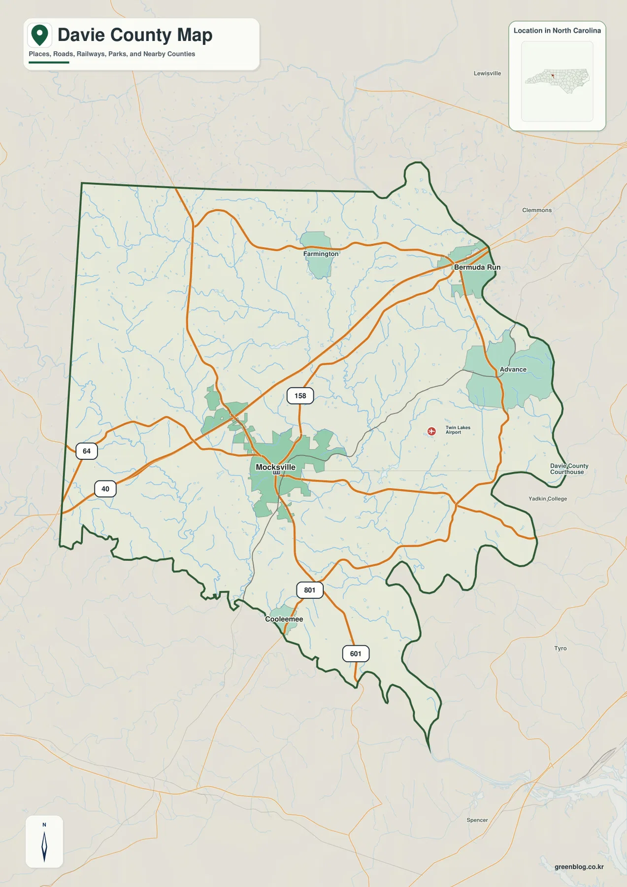
Mocksville appears near the center of Davie County and gives the clearest first reference for the road map. I-40 crosses the central part of the county near town, while US 64 enters from the west and links into the same general area. US 158 runs through the northern-central section, and routes marked 801 and 601 continue toward the southern part of the county. The result is a road pattern in which Mocksville is useful for orientation even when the final destination is Bermuda Run, Farmington, Advance, or Cooleemee.
The county map also places smaller communities in a useful order. Farmington is north of Mocksville, Bermuda Run is in the northeast, and Advance sits below Bermuda Run along the eastern side. Cooleemee is separated from that group near the south edge. Labels outside the county show Yadkin County to the north and Davidson, Forsyth, Iredell, and Rowan County directions around the perimeter, so the map can be used to understand where Davie County fits among nearby Piedmont counties without losing the local roads inside the boundary.
Bermuda Run gives the northeast corner a different reference point
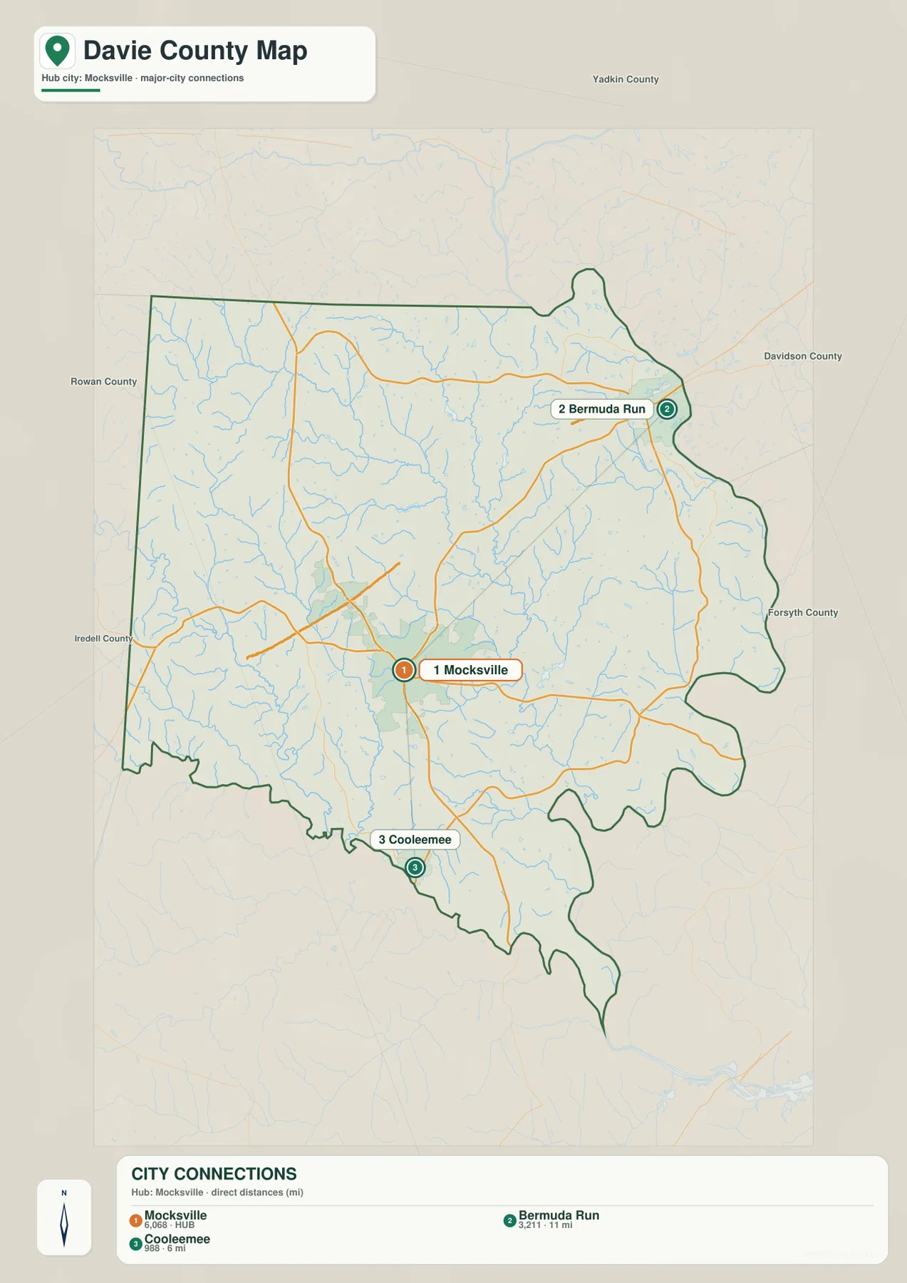
Bermuda Run is not simply another label close to Mocksville. On the city map it is clearly displaced toward the northeast edge of Davie County, while Mocksville remains in the central interior. The county map adds nearby roads and outside labels such as Clemmons and Lewisville, showing that Bermuda Run lies much closer to those northeast-side reference points than Mocksville does. That contrast is useful when a reader is trying to understand a local address, a travel route, or the direction of a neighboring county.
Advance reinforces the same northeast-side pattern but sits south of Bermuda Run. Farmington, by contrast, is farther west across the northern part of the county. These positions matter because a simple county-seat description can make Davie County sound more compact than it looks on the map. Once Bermuda Run, Advance, and Farmington are added, the northern half spreads across several directions, while the southern half narrows toward Cooleemee and the South Yadkin River.
Cooleemee and the South Yadkin River define the southern side
The southern part of Davie County is easier to understand from the water map than from city labels alone. Cooleemee is close to the south edge, and the South Yadkin River follows the lower portion of the county before continuing eastward. The river gives this part of the boundary a strong natural reference that is very different from the road-focused center around Mocksville. The broader Yadkin River on the eastern side provides another strong natural boundary reference, so river geography is central to the shape of Davie County rather than a minor decorative feature.
Several interior streams feed toward the larger river network. Their courses are not straight, and the county boundary itself becomes more irregular toward the south. That makes the terrain-and-water view particularly helpful around Cooleemee, where a reader can compare the town, the county edge, and the river in one frame. It is also a useful reminder that a road map and a hydrography map answer different questions: one shows how people move through the county, while the other shows the natural channels that cross and border it.
Creeks and small lakes reveal detail that the road map cannot show
The terrain-and-water map names a dense set of smaller features inside Davie County. Frost Mill Creek and Cedar Creek are prominent in the north and north-central area. Bear Creek and Hunting Creek run through the western and central-southwestern side, while Elisha Creek, Dutchmans Creek, and Elsworth Creek appear farther east. Little Creek is labeled near the southwest. These streams give the county interior much more structure than is visible on the simpler city map.
Several lakes provide additional landmarks. Lake Myers and Mocksville Lake are shown west and southwest of the central area, Cedar Creek Lake is farther north, and Dutchmans Creek Lake appears east of center. Whip-o-will Farms Number One Lake is marked near the northern part of the county. None of these water bodies dominates Davie County the way a large reservoir would, but together they help readers locate individual drainage areas and distinguish one part of the county from another.
The shaded background on this map is useful for seeing general terrain relief, but it should not be treated as a separate elevation map. No point-by-point elevation values are supplied in this package. The relief is best used to notice where stream valleys and rolling ground create changes in the surface, while exact heights should be checked from a dedicated elevation source when that level of precision is needed.
Roads and waterways work best as two separate layers of the same county
A reader looking for a town or driving corridor should begin with the county map. Mocksville, I-40, US 64, US 158, and the routes toward Bermuda Run and Cooleemee are easier to follow there because water detail stays in the background. The city map is even cleaner when the only question is whether Bermuda Run is northeast or Cooleemee is south of Mocksville. For streams, river edges, and small lakes, the water map is the better choice because it removes much of the visual competition from road labels.
Using the maps this way also prevents several common misunderstandings. Bermuda Run should not be treated as if it were adjacent to central Mocksville, and Cooleemee should not be located by road direction alone when the South Yadkin River is such a strong nearby reference. Likewise, the shaded terrain should not be converted into guessed elevations. Each map is most reliable when it is used for the information it actually displays.
The download ZIP contains the three high-resolution A3 JPG maps represented on this page: the county map, city map, and terrain-and-water map. They are useful for printing, classroom material, regional comparison, and offline reference when the web previews are too small. The package does not include a separate elevation map, so the download list below matches the actual available files rather than adding a map type that is not present.
Frequently Asked Questions
Why is Mocksville the easiest place to start reading a Davie County map?
Mocksville is near the county’s central interior and is surrounded by several of the major roads shown on the map, including I-40 and routes connecting north, west, and south. Once Mocksville is located, Bermuda Run, Farmington, Advance, and Cooleemee can be placed in relation to it without treating the county as one uniform cluster.
What does the South Yadkin River add to the map around Cooleemee?
The South Yadkin River gives the southern edge a clear natural reference. Cooleemee sits close to that part of the county, so the water map explains its position better than a city-only view. It also shows why the southern boundary looks more irregular than the road-centered interior.
Is a separate elevation map included in the Davie County download?
No. The package contains a county map, a city map, and a terrain-and-water map. Shaded relief is visible behind the water features, but it does not provide the numerical elevation information of a dedicated elevation map.
Sources and Reference Data
These references provide background on Davie County and official source material for boundaries, hydrography, and terrain data used in map work.
- NCpedia – Davie County
- U.S. Census Bureau TIGER/Line Shapefiles
- USGS National Hydrography
- USGS 3D Elevation Program
Map File Information
Download the high-resolution A3 JPG maps for Davie County in one ZIP file. The larger images are suitable for printing, classroom use, and local reference.
- Included Files: 3 high-resolution A3 JPG maps described on this page
- File Type: JPG files in a ZIP archive
- Intended Use: Printing, education, presentations, and map-based projects
Related Maps
Green Map creates custom-edited map images using open geographic data sources such as geoBoundaries, Natural Earth, OpenStreetMap, and government open data.
These maps are edited visual materials, not raw data files, and are provided for education, documents, presentations, and graphic reference.