Duplin County lies across a broad part of eastern North Carolina, with Kenansville near the middle, Warsaw and Rose Hill to the west, Wallace near the southern edge, and Beulaville farther east. This page provides a county map for roads and boundaries, a simplified city map for comparing major settlements, and a water and terrain map that highlights the Northeast Cape Fear River, Goshen Swamp, creeks, ponds, and smaller drainage features. If you need larger files for printing or reference work, the download box near the end of the page contains the matching high-resolution A3 JPG maps in one ZIP archive.
The county makes more sense when its separate settlement areas are viewed together rather than treating Kenansville as the center of everything. I-40 and US 117 connect a string of towns on the western side, while Beulaville and other eastern places sit closer to the Northeast Cape Fear River system. The three maps separate those layers so that roads, town locations, and waterways do not compete for attention at the same time.
Table of Contents
Start with Kenansville to orient the county
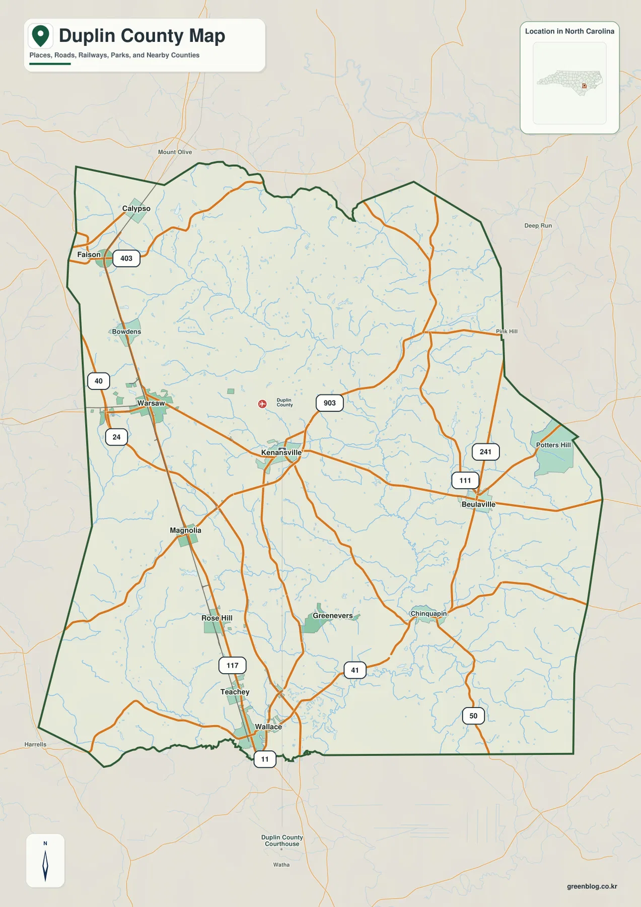
Kenansville is the county seat and appears close to the middle of Duplin County, making it a practical first reference on the general map. Route 24 crosses the central part of the county through the Kenansville area, while Route 11 and Route 903 provide north-south connections nearby. From this central position, Warsaw and Magnolia are to the west, Wallace is farther south, and Beulaville is to the east. That spread quickly shows why Duplin is not a compact county centered on one continuous urban area.
The neighboring county labels help place Duplin within eastern North Carolina without turning the map into a list of directions. Wayne County forms the upper reference, while Lenoir, Jones, and Onslow identify the counties reached across the eastern side. Pender and Sampson define much of the lower and western context. Duplin does not reach the Atlantic coast, but the map clearly places it within the Coastal Plain between inland communities and counties that lead toward the coast.
I-40 and US 117 connect the western towns
The western side of Duplin County has the clearest chain of towns and major transportation routes. Faison and Calypso appear near the northwest, Warsaw lies farther south, and Magnolia, Rose Hill, Teachey, and Wallace continue toward the county’s southern edge. I-40 runs through this side of the county and passes the Warsaw-to-Wallace corridor, while US 117 follows a similar north-south part of the map. Those two roads make the western settlements easier to trace than many of the smaller communities in the interior.
Wallace is especially useful as a southern reference because it is close to the county line and sits around the junction of Routes 11 and 41. Rose Hill and Teachey are just to its north, with Magnolia between the Rose Hill area and Warsaw. The map therefore shows a series of separate town centers rather than one continuous city. When comparing Duplin with more urban counties, this spacing is one of the most noticeable differences on the page.
How Wallace, Warsaw, Rose Hill, and Beulaville are spaced
The city map removes many smaller labels and emphasizes six major places: Wallace, Warsaw, Rose Hill, Beulaville, Kenansville, and Magnolia. Wallace is near the southern edge, Warsaw is in the northwest, Rose Hill is southwest of the center, and Beulaville is clearly separated on the eastern side. Kenansville sits between these outer places, while Magnolia fills part of the western gap between Warsaw and Rose Hill. This simpler layout is useful when the general road map feels crowded.
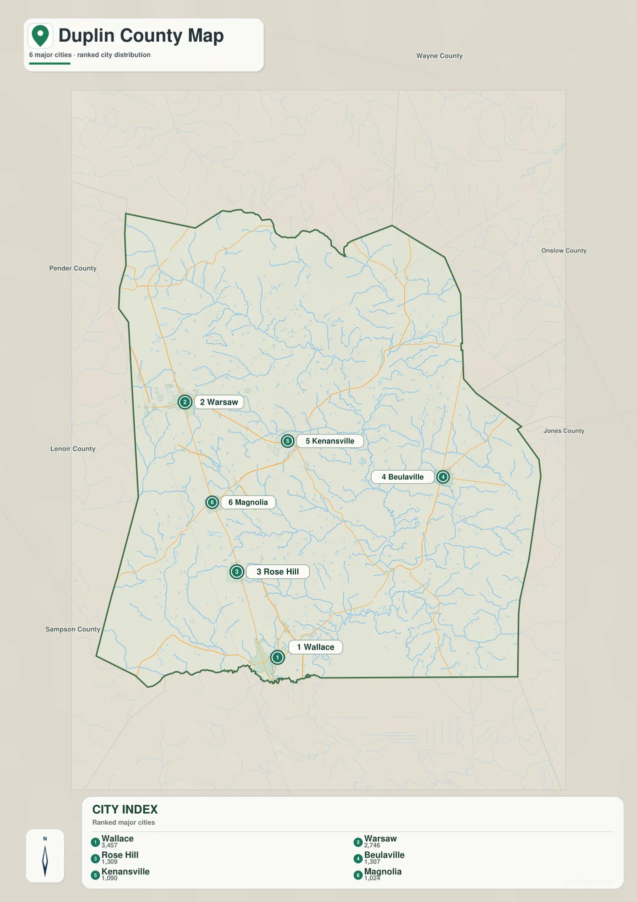
The ranked city index on the map also illustrates an important distinction between population and government function. Wallace and Warsaw are shown as the two largest places in the index, while Kenansville ranks lower even though it is the county seat. Rose Hill, Beulaville, and Magnolia are smaller but still useful location references because they occupy different parts of the county. For map reading, administrative role, settlement size, and geographic position should be treated as separate pieces of information.
Follow the Northeast Cape Fear River through the eastern half
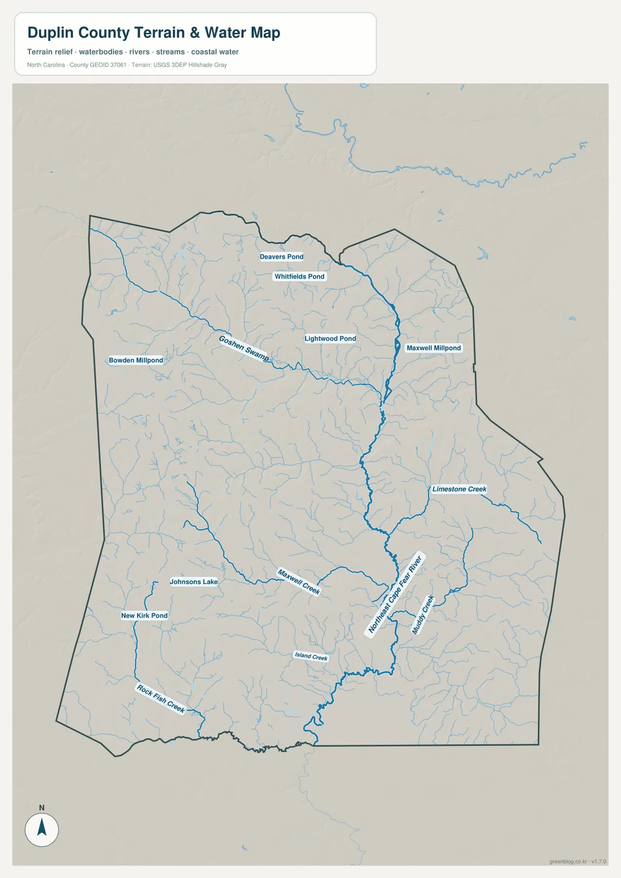
The Northeast Cape Fear River is the strongest water feature on the supplied terrain and water map. It runs through the central-eastern part of Duplin County and continues toward the southern boundary, receiving a network of smaller streams along the way. Muddy Creek joins the system from the southeast, and Limestone Creek is labeled farther east. The density of thin tributary lines around the main river makes the water map look very different from the road map, even though both cover the same county.
Goshen Swamp is another major reference, extending across the northwestern and central part of the county. Deavers Pond and Whitfields Pond appear near the northern side, Lightwood Pond is farther toward the middle, and Maxwell Millpond is near the northeastern drainage area. In the southwest, Johnsons Lake and New Kirk Pond provide smaller landmarks, while Rock Fish Creek runs toward the southern boundary. Maxwell Creek and Island Creek add more detail to the southern half. Together, these features show a county crossed by many modest waterways rather than dominated by one large lake.
Waterways stand out across the gentle Coastal Plain terrain
The water map includes shaded relief as a background aid, but the package does not contain a separate elevation map for reading exact heights. The visible terrain is comparatively gentle, with streams and swamp drainage standing out more than steep mountain slopes or deep valleys. For that reason, the useful terrain story here is not a list of elevation numbers. It is the way numerous small channels spread across the county and feed larger features such as Goshen Swamp and the Northeast Cape Fear River.
This becomes clear when the water map is compared with the road map. I-40, Route 24, Route 11, and other highways organize travel between towns, while the blue stream network follows a much more branching pattern. In rural areas between the named towns, the water map fills what looks like open space on the general map with creeks, ponds, and swamp channels. That comparison can be useful for classroom projects, county overviews, and regional reference work where both built and natural features matter.
Choose the Duplin County map that matches the task
Use the general county map when you need roads, towns, county boundaries, and nearby counties on one page. It is the best starting point for finding Kenansville and then tracing routes toward Warsaw, Wallace, Beulaville, or the county edges. The city map is cleaner when the goal is simply to compare where the main settlements sit relative to one another. Its six highlighted places make the western and eastern separation much easier to see.
The water and terrain map is the better choice for rivers, creeks, swamps, and ponds. Start with the Northeast Cape Fear River and Goshen Swamp, then work outward to Maxwell Creek, Muddy Creek, Limestone Creek, Rock Fish Creek, and the labeled ponds. Because this is not a live navigation or flood map, it should be used for general orientation and geographic reference rather than real-time road conditions, property boundaries, or flood determinations.
For printed material, presentations, or any project that needs more detail than the web previews provide, use the ZIP below. It contains the same county, city, and water/terrain maps as high-resolution A3 JPG files. Keeping the three files separate lets you choose a cleaner settlement view for a report, a detailed road map for location work, or a water-focused image for a natural-environment section without forcing every layer into one graphic.
Frequently Asked Questions
How are Kenansville and Wallace positioned differently on the map?
Kenansville is near the middle of Duplin County and serves as the county seat, while Wallace is close to the southern boundary in the western road corridor. Looking at both places together helps show the county’s north-south scale and the difference between the administrative center and a larger southern settlement.
Where is the Northeast Cape Fear River on the Duplin County water map?
It appears as the strongest blue river line through the central-eastern part of the county and continues toward the south. Smaller waterways such as Muddy Creek and Limestone Creek connect into the same broader drainage area, while Goshen Swamp provides another major water reference farther west.
Does this download include a separate Duplin County elevation map?
No. The current package contains a county map, a city map, and a water/terrain map. The water map uses shaded relief to make the land surface easier to see, but it is not a dedicated elevation map for reading exact height values.
Map File Information
The ZIP contains high-resolution A3 JPG versions of the Duplin County map, city map, and water/terrain map. Use these larger files when you need more detail than the web previews provide.
- Included Files: Three map versions: county, city, and water/terrain
- File Type: High-resolution A3 JPG files in a ZIP archive
- Intended Use: Printing, education, presentations, and map-based projects
Related Maps
Sources and References
These references support county background and the boundary, hydrography, and terrain data used for map context.
- NCpedia – Duplin County
- U.S. Census Bureau TIGER/Line Shapefiles
- USGS National Hydrography
- USGS 3D Elevation Program
Green Map creates custom-edited map images using open geographic data sources such as geoBoundaries, Natural Earth, OpenStreetMap, and government open data.
These maps are edited visual materials, not raw data files, and are provided for education, documents, presentations, and graphic reference.