Brooks County lies in inland South Texas, with Falfurrias near the county’s northeastern side rather than at its geographic center. This page brings the county, city, water, and elevation views together so the road pattern, named creeks, and broad west-to-east drop can be compared in one place. You can download the supplied high-resolution A3 JPG maps together in one ZIP file for printing, classroom use, or offline reference. On the maps, U.S. 281 runs south toward Encino, named creeks and small lakes cluster mainly in the north, and higher western ground gives way to lower terrain toward the east.
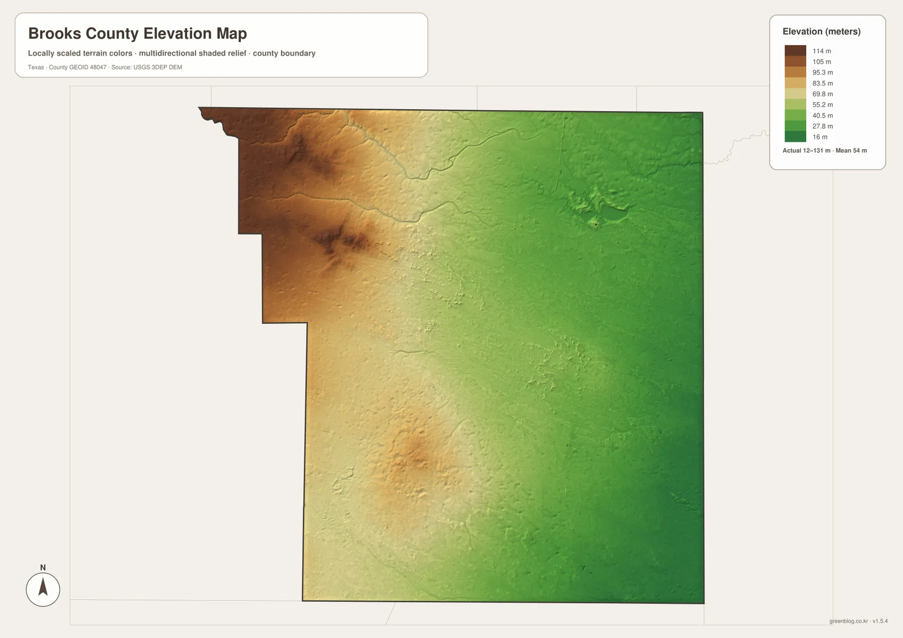
The county is large enough that a single road or place-name map does not tell the whole story. The boundary map is best for orientation and road access, while the city map strips the scene down to the ranked urban center. The terrain-and-water map highlights features such as Arroyo Baluarte, Los Olmos Creek, Mesquite Lake, and Charco Salado Lake. The elevation map adds another layer by showing a clear west-to-east contrast, with local highs in the western and northwestern part of the county and lower, greener terrain across the east.
Table of Contents
Falfurrias, the County Shape, and the First Map to Read
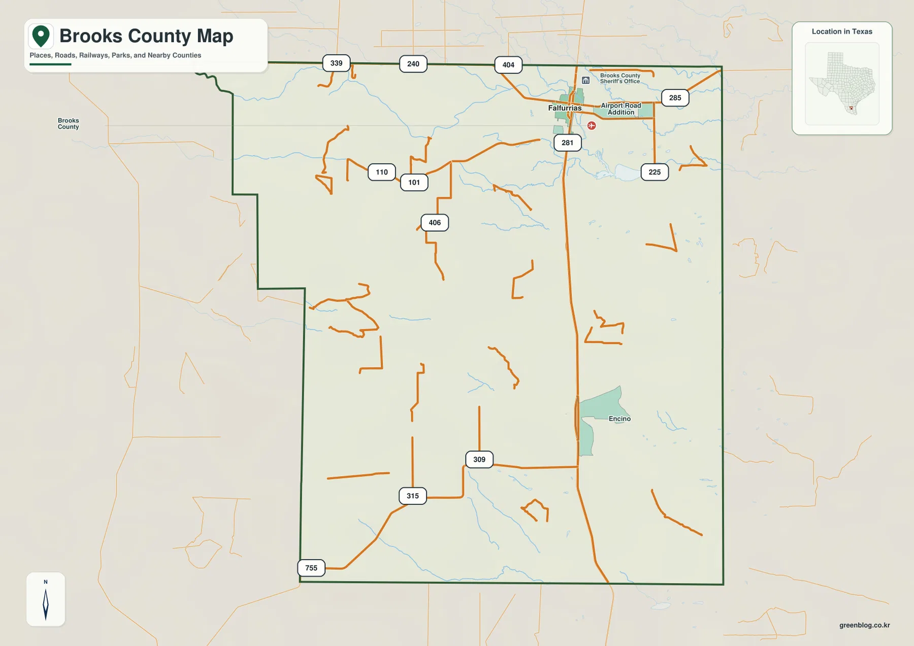
The general county map gives the most complete first look at Brooks County. Its outline is not a simple rectangle: the western side steps inward in several places, while the northern and eastern edges form longer straight sections. Around that boundary are Duval and Jim Wells counties to the north, Kleberg and Kenedy to the east, Hidalgo and Starr to the south, and Jim Hogg to the west. Seeing those neighbors matters because the numbered roads on the map do not stop being useful at the county line; they connect Brooks County with a broader South Texas road network.
Falfurrias stands out near the northeastern part of the county, where U.S. 281 and State Highway 285 meet and several smaller numbered routes spread into the surrounding area. The map also marks Encino farther south along the U.S. 281 corridor. Between and beyond those places, road spacing becomes much wider and the map contains large areas without dense settlement labels. That open appearance is an important part of the county’s geography, not simply an absence of information.
U.S. 281 Links Falfurrias with the Sparse Southern Interior
U.S. 281 is the easiest route to follow from north to south on the county map. It passes Falfurrias, continues down the eastern side of the county interior, reaches the Encino area, and then leaves Brooks County at the southern boundary. Around Falfurrias, the highway is joined by a denser group of numbered roads, including 285 and several farm-to-market or ranch-road routes. Farther south, those lines thin out and become more widely separated. The resulting contrast makes the northern service center and the more sparsely settled southern landscape visible without relying on population statistics.
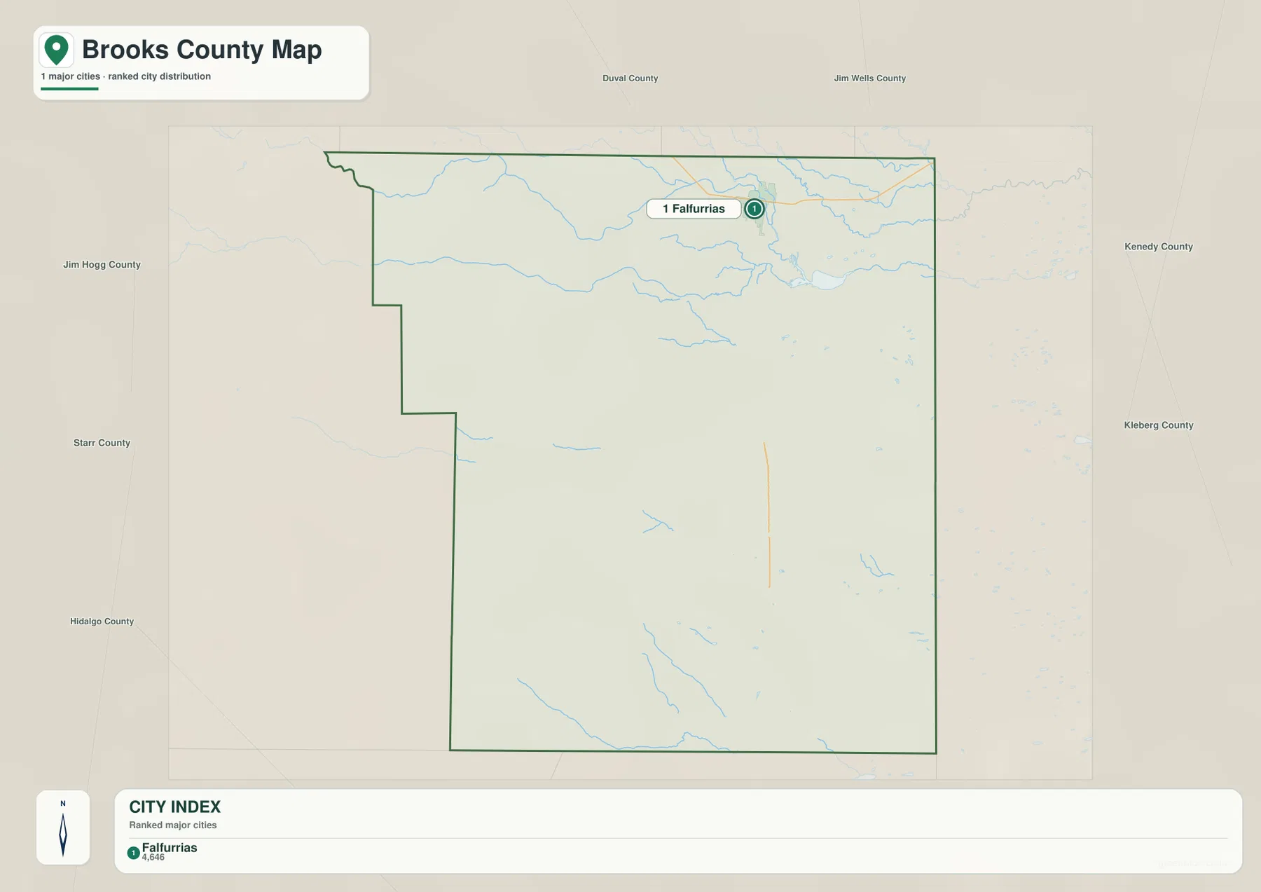
The city-distribution map simplifies that pattern even further. In the supplied version, only Falfurrias appears in the ranked major-city index. Because there is only one ranked city, the map does not draw intercity connector lines or distance labels. On county maps that do use such connectors, those distances are straight-line measurements rather than driving mileage; here, however, the main value of the city map is simply locating the county’s dominant urban center within a much larger rural area. Comparing it with the road map shows how closely that center aligns with the county’s strongest road concentration.
Named Creeks and Small Lakes Cluster Across the North
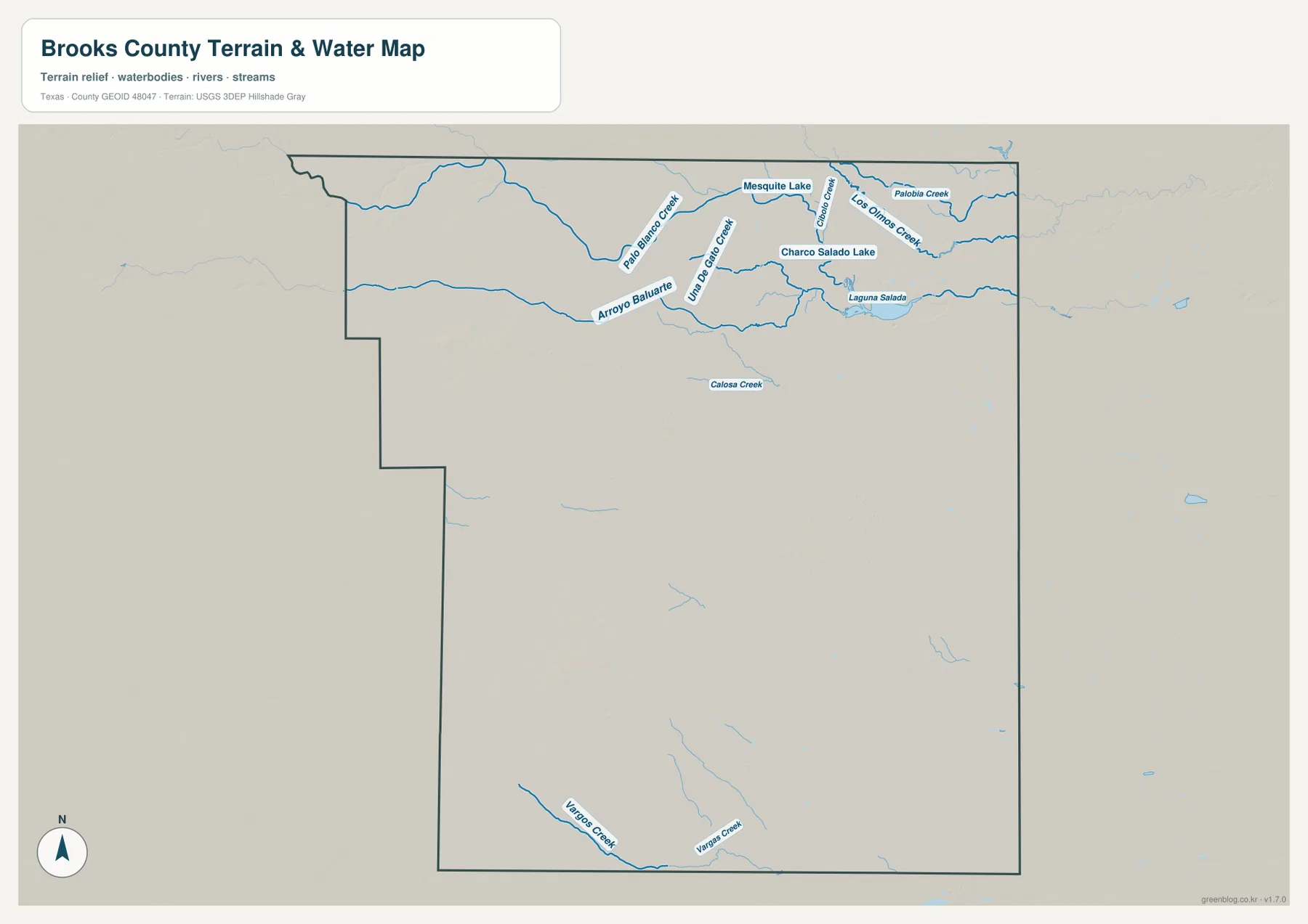
The terrain-and-water map shifts attention away from roads and toward drainage features. Arroyo Baluarte crosses the northern part of the county, while Palo Blanco Creek and Junta de Gallo Creek appear nearby. Farther east, Los Olmos Creek, Cibolo Creek, and Palobia Creek form another group of named channels. This northern concentration is one of the clearest differences between the water map and the general road map: a part of the county that may look relatively open on the road layer contains a much richer network of named natural features.
Several small water bodies are also labeled in the north, including Mesquite Lake, Charco Salado Lake, and Laguna Salada. Calosa Creek appears farther toward the center, while the southern edge contains the labeled Vargas Creek and Vargos Creek channels. The southern half still has thin drainage lines, but the named features are much less dense than they are near the northern boundary. This map should be used as a reference for terrain, streams, and water bodies; it is not a flood-risk map, parcel map, legal water-rights document, or navigation chart.
The Elevation Map Reveals a Broad West-to-East Drop
The elevation map adds a feature that is easy to miss on a conventional county map. Browns and tans dominate the western and northwestern sections, marking higher ground, while light green and darker green spread across the east where elevations are lower. The legend gives an actual range of about 12 to 131 meters and a mean of about 54 meters. Brooks County is not mountainous, but the color transition is strong enough to show that the landscape is not perfectly level across its full width.
Higher pockets and shallow relief are especially noticeable in the northwest and in a smaller western-central area. East of those zones, the terrain becomes more consistently low and subdued. When the elevation map is placed beside the water map, the northern drainage network can be viewed against this gradual change in height rather than as isolated blue lines. The surface is based on USGS 3DEP elevation data and is useful for regional comparison, but it should not be treated as survey-grade elevation for engineering, construction, property boundaries, or site-specific grading decisions.
Why the Northeastern Location of Falfurrias Matters
The Texas State Historical Association describes Falfurrias as Brooks County’s largest town and county seat, located in the northeastern part of the county at the junction of U.S. 281 and State Highway 285. That description matches what the road map shows: Falfurrias is not merely the largest label, but the point where the county’s strongest road concentration is visible. The City of Falfurrias also traces the town’s growth to ranching, the arrival of the railroad, agriculture, and later oil and gas activity. Those historical details help explain why the settlement pattern is concentrated in one part of a county that otherwise looks very open.
Brooks County was organized in 1911 with Falfurrias as its county seat. Its modern outline later changed when Jim Hogg County was formed to the west, which helps explain the stepped shape visible on the current boundary map. The page does not need a long history lesson to make that useful: the key point is that the present county boundary, the northeastern location of Falfurrias, and the road network are connected pieces of the same regional story. A reader looking only at the city symbol would miss that relationship.
Reading a Map of Sand Sheet and Brush Country
Regional descriptions of Brooks County emphasize sandy soils, brush, mesquite, and broad stretches of open land. That background matters when the road map is interpreted. Large blank spaces between labeled routes do not mean that the map failed to capture a chain of towns; in many parts of the county, settlement is genuinely sparse and roads cross long rural distances. The pattern is especially noticeable away from Falfurrias and the U.S. 281 corridor, where the map becomes quieter and the spacing between visible roads increases.
The phrase South Texas Sand Sheet describes a regional landscape and soil setting, not a legal land-use category or property designation. It should not be used to infer ownership, zoning, development rights, or access to a specific parcel. The same caution applies to the other maps on this page. The water layer is for locating named streams and lakes, and the elevation layer shows broad terrain differences. Keeping those purposes separate makes the collection more useful because each map can answer a clear geographic question without being asked to provide information it was not designed to show.
Which Brooks County Map Fits the Task?
Use the county map when the main question is where a place, road, or boundary lies. It is the best choice for finding Falfurrias, following U.S. 281 toward Encino, checking the county outline, and understanding how routes leave Brooks County toward adjacent counties. The city map is intentionally more limited: it isolates the ranked city distribution and makes the prominence of Falfurrias immediately obvious. That simplicity can be useful in a presentation or lesson where a detailed road network would distract from the settlement pattern.
Choose the water map when a named creek or small lake is the subject. Arroyo Baluarte, Los Olmos Creek, Mesquite Lake, and Charco Salado Lake are much easier to locate there than on the general map. For terrain questions, the elevation map is the clearest option because its color ramp shows the higher west and lower east at a glance. Readers comparing transportation with physical geography may get the most value from placing the county, water, and elevation maps side by side rather than trying to force every detail into one layer.
Frequently Asked Questions
Where is Falfurrias within Brooks County?
Falfurrias is near the northeastern part of the county, close to the junction of U.S. 281 and State Highway 285. On the full boundary map it is clearly offset toward the north and east rather than sitting near the center of the county.
What stands out most on the Brooks County water map?
The strongest feature is the concentration of named creeks and small lakes across the north. Arroyo Baluarte, Palo Blanco Creek, Los Olmos Creek, Mesquite Lake, Charco Salado Lake, and Laguna Salada create a much denser labeled water network there than in the southern half.
What elevation difference does the supplied map show?
The legend shows an actual county range of roughly 12 to 131 meters, with a mean near 54 meters. The western and northwestern areas are higher overall, while lower green terrain occupies much of the east. Those values are appropriate for regional comparison, not a substitute for a site survey.
Map File Information
The download ZIP contains the original A3 high-resolution JPG versions of the Brooks County boundary map, city map, terrain-and-water map, and elevation map. Use these files when you need larger images for printing, classroom materials, presentations, or offline reference.
- File Type: JPG files inside a ZIP archive
Related Maps
- Starr County
- Webb County Texas map
- Willacy County Texas map
- Zapata County Texas map
- San Patricio County Texas map
Sources and References
- Texas State Historical Association – Brooks County for county boundaries, settlement history, Falfurrias, and regional geography.
- City of Falfurrias – History for local history and the formation of Brooks County.
- USGS The National Map Viewer for national map layers and geographic reference data.
- USGS National Hydrography for streams and water-feature reference data.
- USGS 3D Elevation Program for the elevation data used in regional terrain mapping.
Green Map creates custom-edited map images using open geographic data sources such as geoBoundaries, Natural Earth, OpenStreetMap, and government open data.
These maps are edited visual materials, not raw data files, and are provided for education, documents, presentations, and graphic reference.