Davidson County sits in North Carolina’s central Piedmont, with Lexington near the middle of the county’s main road network, Thomasville to the northeast, and a much longer rural stretch reaching south toward Southmont and Denton. The maps on this page make those differences easy to see because they combine town locations, major highways, county boundaries, lakes, and a dense network of creeks. A downloadable ZIP is also provided below with high-resolution A3 JPG versions of the county, city, and water maps.
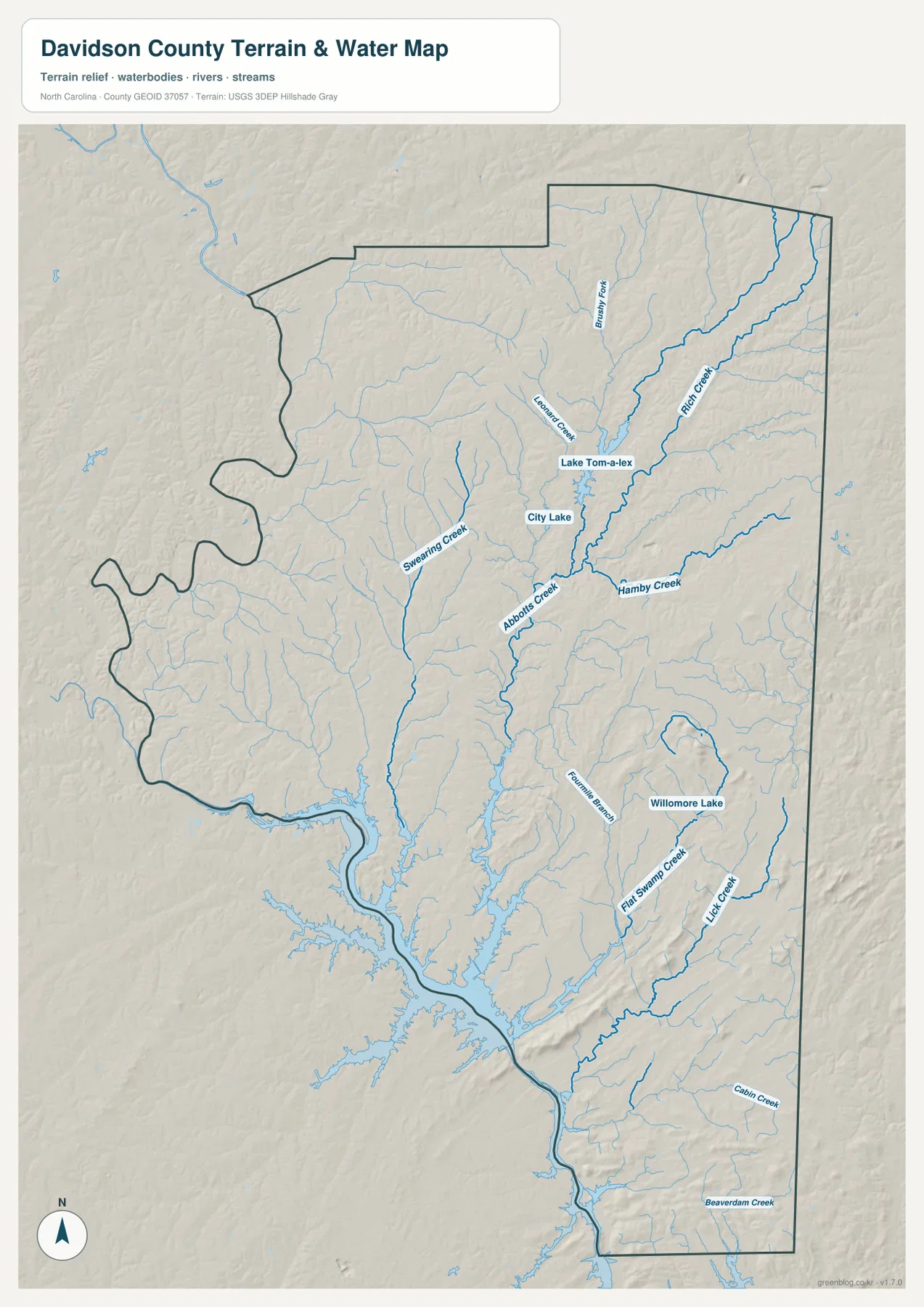
One map is not enough to show every useful detail. The general county view is best for roads and neighboring counties, while the city view strips the picture down to the main settlement pattern. The water and terrain map adds Lake Thom-A-Lex, City Lake, Abbotts Creek, Rich Fork Creek, Swearing Creek, and many smaller tributaries. Used together, the maps show why northern Davidson County feels more urban and connected while the southern half opens into a broader landscape of reservoirs, creeks, and smaller communities.
Table of Contents
Start with Lexington to orient the county
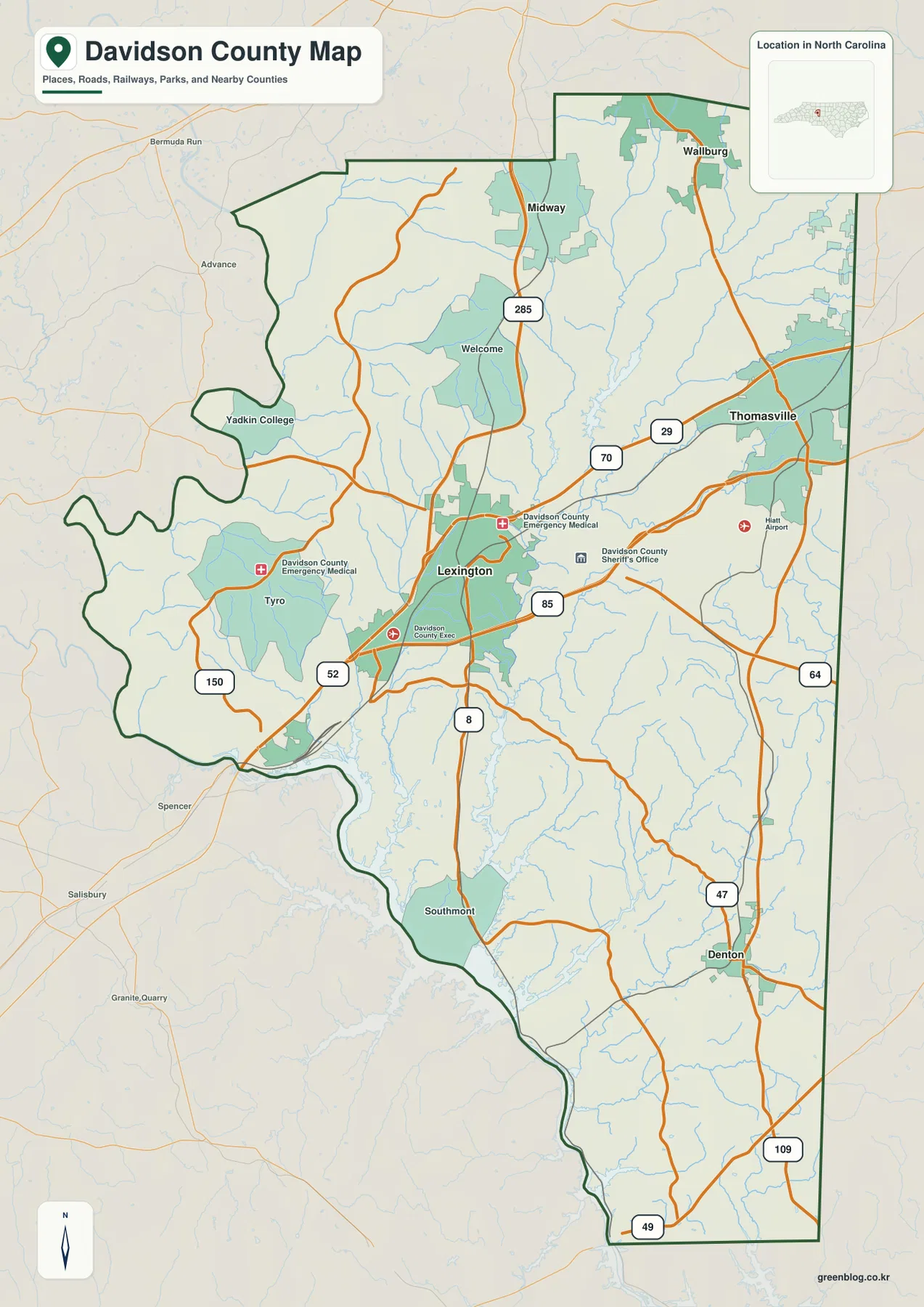
Lexington is the county seat and appears slightly north of the geographic middle of Davidson County. It is also where several of the map’s most useful road references come together. I-85 and the US 29/70 corridor pass across the northern-central part of the county, US 52 approaches from the northwest and continues toward Lexington, and NC 8 runs south from the city. That combination makes Lexington a practical starting point for reading the rest of the map rather than merely a label marking the county government center.
From Lexington, the county spreads in several distinct directions. Tyro and Yadkin College lie to the west, Welcome and Midway are farther north, and Thomasville forms a separate northeastern focus. Southmont sits near the large reservoir area in the southwest, while Denton is much farther southeast. The map also places Davidson County among Rowan and Davie counties to the west, Forsyth County to the north, Guilford and Randolph counties to the east, and Montgomery and Stanly counties along the southern side. Those boundary relationships help explain why different parts of Davidson connect toward different neighboring areas.
Thomasville and the northern settlement cluster
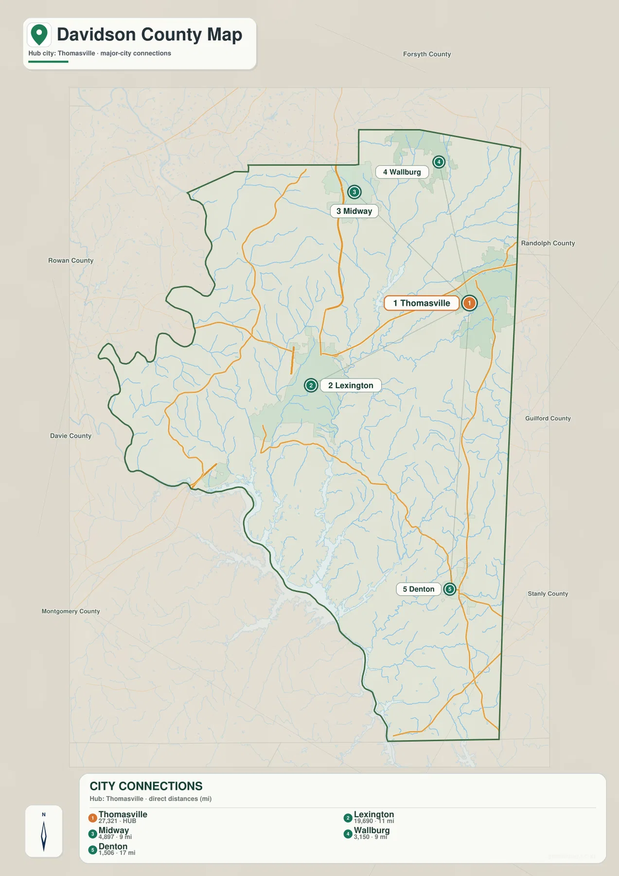
Thomasville deserves its own place in the county description because it is not simply an extension of Lexington. It lies to the northeast near the Guilford County side, while Lexington is farther southwest. Midway and Wallburg sit north of the two larger cities, creating a clear group of named communities in the upper part of the county. On the city map, these places are isolated from smaller labels and shown with simple numbered markers, making the northern concentration especially easy to compare.
This pattern also explains why northern Davidson looks busier on the road map. Major routes cross between Lexington and Thomasville and continue toward Forsyth and Guilford counties, while the southern half has longer gaps between named towns. The difference is useful when planning a county overview, choosing a reference point for a school project, or simply trying to understand why two addresses in Davidson County can feel as though they belong to very different local settings.
Following the road network south toward Denton
South of Lexington, NC 8 gives the clearest north-to-south reference through the middle of the county. Farther east, NC 109 and NC 47 meet around the Denton area, and US 64 crosses the central-eastern part of Davidson. These routes help connect the compact northern settlement pattern with the longer southern portion of the county. On the general map, the road spacing becomes wider as the view moves away from Lexington and Thomasville, while streams and irregular boundary lines become more visually prominent.
Denton is especially useful as a southern orientation point because it sits far from the two larger northern cities and close to the eastern side of the county. Southmont serves a different role near the large reservoir shoreline in the southwest. Reading both places keeps the county from being reduced to a Lexington–Thomasville description. It also shows that travel across Davidson often involves moving around water, following curving state routes, and crossing a landscape where smaller communities are separated by larger undeveloped areas.
High Rock Lake and the broad southwestern water edge
High Rock Lake is one of the strongest physical references for western and southwestern Davidson County in the supplied material. The current county information identifies the lake and the Yadkin River as major natural orientation features, and the water map shows a large branching reservoir entering the county’s southwestern side. The shoreline is deeply indented by coves and tributaries, which creates a very different boundary shape from the straighter northern and eastern edges of the county.
Southmont is positioned close to this reservoir environment, while Lexington lies well to the north. That separation matters because the lake is not simply a scenic feature placed at the edge of the page; it changes how the southwestern part of the county is organized. Roads bend around water, smaller streams feed the reservoir, and the county boundary follows a more irregular course. For a reader trying to understand Davidson at county scale, the reservoir provides a natural anchor that complements the city-and-road references farther north.
Creeks and small lakes fill in the interior geography
The water map adds detail that the road-focused view cannot show clearly. Lake Thom-A-Lex and City Lake appear in the northern-central part of the county, close to Leonard Creek and the larger Rich Fork Creek system. Brushy Fork enters from the north, while Hamby Creek is labeled farther south and east. Abbotts Creek runs through the middle of the county toward the reservoir, and Swearing Creek follows a separate course to its west. Together, these waterways give the interior of Davidson a much more connected appearance than the general map suggests at first glance.
The southeastern half contains another set of named streams. Flat Swamp Creek and Lick Creek are visible around the area north and east of Denton, while Cabin Creek and Beaverdam Creek appear farther south. Wilmore Lake is also marked within the eastern interior. These labels are useful because they show that the long southern section of Davidson is not an empty space between Lexington and the county line. It is divided by numerous small drainage valleys, local lakes, and tributaries that shape the terrain and influence where roads can take straighter or more winding routes.
The shaded background on this map should be treated as terrain relief, not as a separate elevation map with exact height values. It helps show where creek valleys and rolling ground occur, but it does not provide numeric elevations for individual points. That distinction matters when using the map for general geographic understanding: the relief can explain why the landscape looks uneven, while exact elevation questions require a dedicated elevation dataset or map.
Which Davidson County map is best for your task?
Use the county map when you need the fullest overview of places, roads, boundaries, and nearby counties. It is the easiest choice for locating Lexington, tracing I-85 or US 64, or checking how Thomasville and Denton sit within the county outline. The city map is better when the main question is settlement location because it removes many secondary labels and highlights Thomasville, Lexington, Midway, Wallburg, and Denton. The water map is the better choice for reservoir shorelines, creeks, small lakes, and the terrain relief behind them.
For printing, classroom material, presentations, or a larger reference image, the ZIP below contains the three map types as high-resolution A3 JPG files. These files are intended for general geographic reference rather than legal boundary determination, parcel work, or live navigation. The larger JPGs preserve more detail than the web previews and make small stream labels and road connections easier to inspect on a full-size screen or printed page.
Frequently Asked Questions
How should I compare Lexington and Thomasville on the map?
Start with Lexington as the county seat near the main central road network, then look northeast to Thomasville near the Guilford County side. Adding Midway and Wallburg to the north and Denton far to the south makes it clear that Davidson has more than one settlement cluster rather than a single city-centered pattern.
Why is the water map useful around High Rock Lake?
The general county map has to share space with roads and place labels, so smaller tributaries are less prominent. The water map emphasizes the large reservoir shoreline together with Abbotts Creek, Swearing Creek, Rich Fork Creek, Lake Thom-A-Lex, City Lake, and other named waterways, making their relationships easier to follow.
Does this download include a separate elevation map?
No. The current package includes a county map, a city map, and a water-and-terrain map. The shaded relief behind the water features helps show rolling ground and creek valleys, but it is not a dedicated elevation map and should not be used to read exact height values.
Sources and Reference Data
These references support the county background and the boundary, hydrography, and terrain datasets associated with the supplied map package.
- NCpedia – Davidson County
- U.S. Census Bureau TIGER/Line Shapefiles
- USGS National Hydrography
- USGS 3D Elevation Program
Map File Information
Download the Davidson County map package as a ZIP containing high-resolution A3 JPG files for larger viewing, printing, and reference use.
- Included Files: Use only the versions confirmed in the article and supplied images
- File Type: Use the confirmed download contents
- Intended Use: Printing, education, presentations, and map-based projects
Related Maps
Green Map creates custom-edited map images using open geographic data sources such as geoBoundaries, Natural Earth, OpenStreetMap, and government open data.
These maps are edited visual materials, not raw data files, and are provided for education, documents, presentations, and graphic reference.