Washington County sits in central Kentucky, with Springfield as the clearest town and road reference, Willisburg to the north, and Mackville to the east. This Washington County Kentucky Map set follows those communities through the local road network, Chaplin River and Beech Fork drainage, and rolling terrain that ranges from about 146 to 311 meters.
High-resolution JPG copies of the maps are available together in a downloadable ZIP after the web previews. The road map works well for Springfield and numbered routes, the city map simplifies the three main community references, and the water and elevation files show why local roads curve through so many valleys and ridges.
Table of Contents
Springfield provides the clearest starting point for the road network
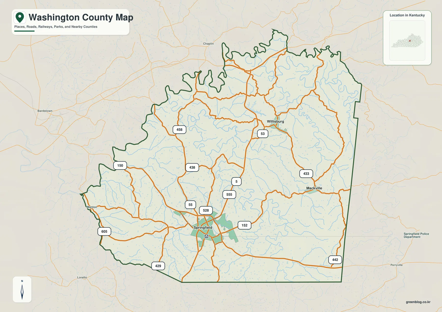
Springfield lies near the south-central part of the county and gathers the most obvious concentration of roads. KY 55 runs through the Springfield area, while KY 152 heads east. North of town, KY 555 and KY 5 provide additional references, and KY 53 continues toward Willisburg. Finding those routes first makes the smaller local roads much easier to place.
Mackville sits east of Springfield near KY 433, while Manton appears toward the western side close to KY 150 and KY 605. KY 438 and KY 458 cross the northwest, and KY 429 and KY 442 mark useful southern-edge routes. The map therefore shows more than a simple hub-and-spoke system: Springfield is the main road focus, but smaller communities and rural corridors create several secondary connections around the county.
The roads become more winding where creek valleys and closely spaced ridges are common. That effect is especially noticeable away from Springfield, where the county map contains many curved local routes. Comparing the same areas with the elevation file later on helps explain why the road network changes character over relatively short distances.
This map is intended for geographic orientation rather than live driving conditions. It does not show current traffic, construction, speed limits, or private access. For navigation, use a current road service alongside it; for understanding how Springfield, Willisburg, Mackville, and the major route numbers fit together, this general map is the most useful file.
Springfield, Willisburg, and Mackville define the simplest city view
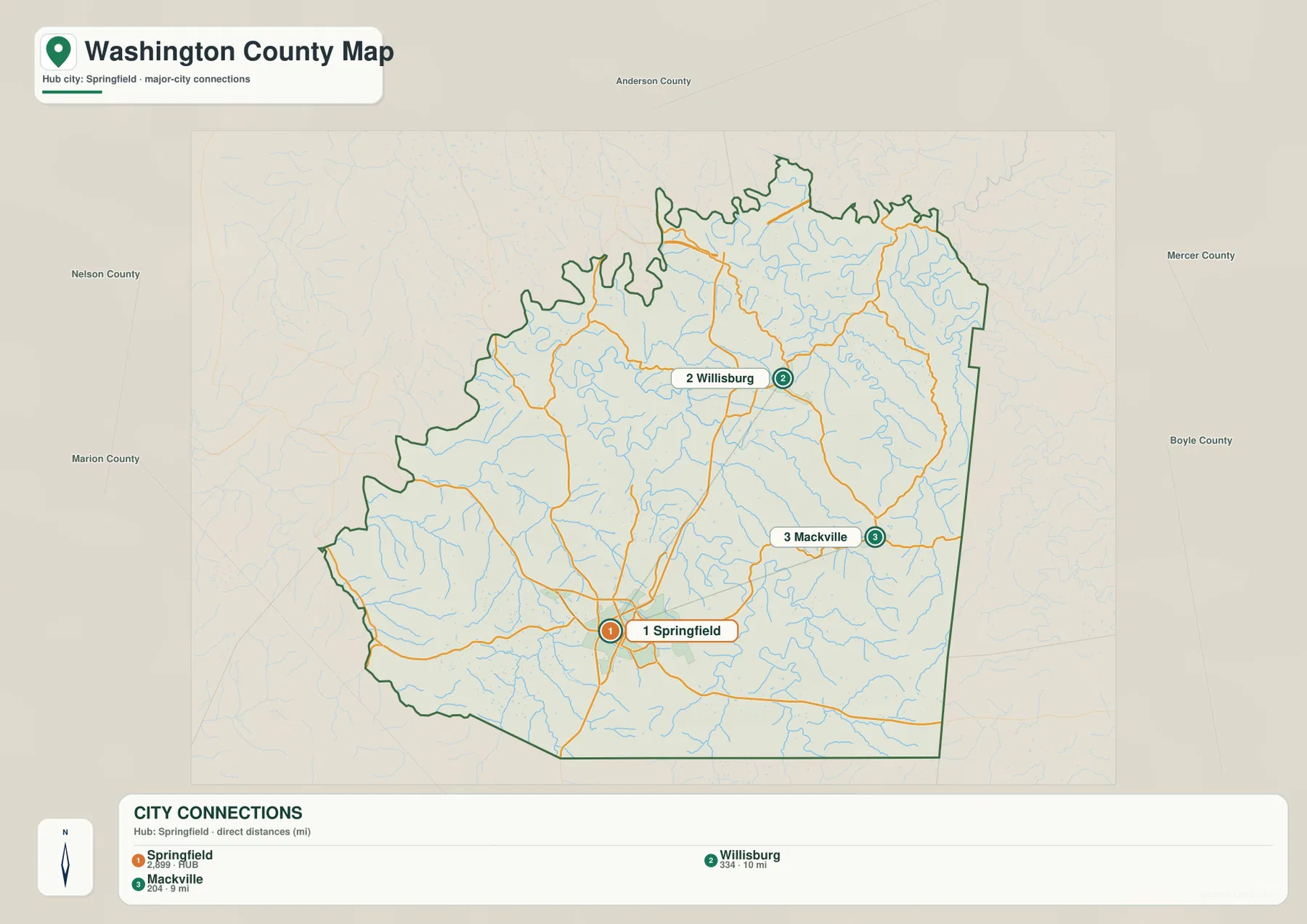
The city-connections map removes most road labels and keeps three places in focus. Springfield is the hub, Willisburg is shown about 10 miles to the north in straight-line distance, and Mackville is about 9 miles to the east. Those values are not driving distances; they are a quick way to understand the county’s scale and the direction of the two smaller city references.
Neighboring county labels provide another layer of orientation. Anderson County lies to the north, Mercer and Boyle Counties are on the eastern side, Marion County is to the southwest, and Nelson County lies west of the county. With those names around the boundary, Springfield’s position within central Kentucky becomes easier to understand even without a detailed statewide map.
The population figures shown in the city index belong to the source snapshot used to build the map and should not be treated as current official counts. Anyone needing recent demographic information should check the U.S. Census Bureau. Here, the useful information is the placement of Springfield, Willisburg, and Mackville and the straight-line relationship among them.
Chaplin River and Beech Fork divide the rolling interior into many small valleys
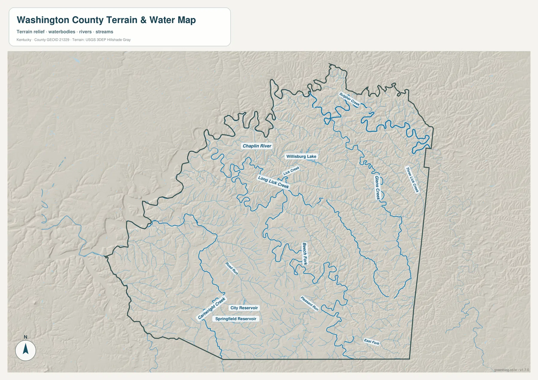
Chaplin River is one of the most visible waterways on the northern half of the map. It bends through the northwest and north-central area, with several short tributaries joining it. Willisburg Lake sits nearby, while Long Lick Creek and Lick Creek occupy separate valleys across the northern interior.
Beech Fork is a major reference farther south and through the middle of the county. Pleasant Run and East Fork appear around the same drainage area, while Cartwright Creek lies to the southwest near City Reservoir and Springfield Reservoir. The number of named and unnamed blue lines shows how strongly small valleys break up the county’s rolling ground.
Glenns Creek and Tatham Lick Creek run through the eastern half, and Sulphur Creek is labeled farther north. These streams are smaller than a large regional river, but they matter for the shape of the landscape because each follows lower ground between ridges. The water map makes those connections much easier to see than the road map alone.
This file is a geographic water reference, not a flood-insurance map, navigation chart, legal shoreline record, or parcel survey. It should not be used to determine flood risk, water depth, fishing rules, or property boundaries. Current agency data should be used for those purposes.
Elevation from 146 to 311 meters highlights the higher east and lower stream valleys
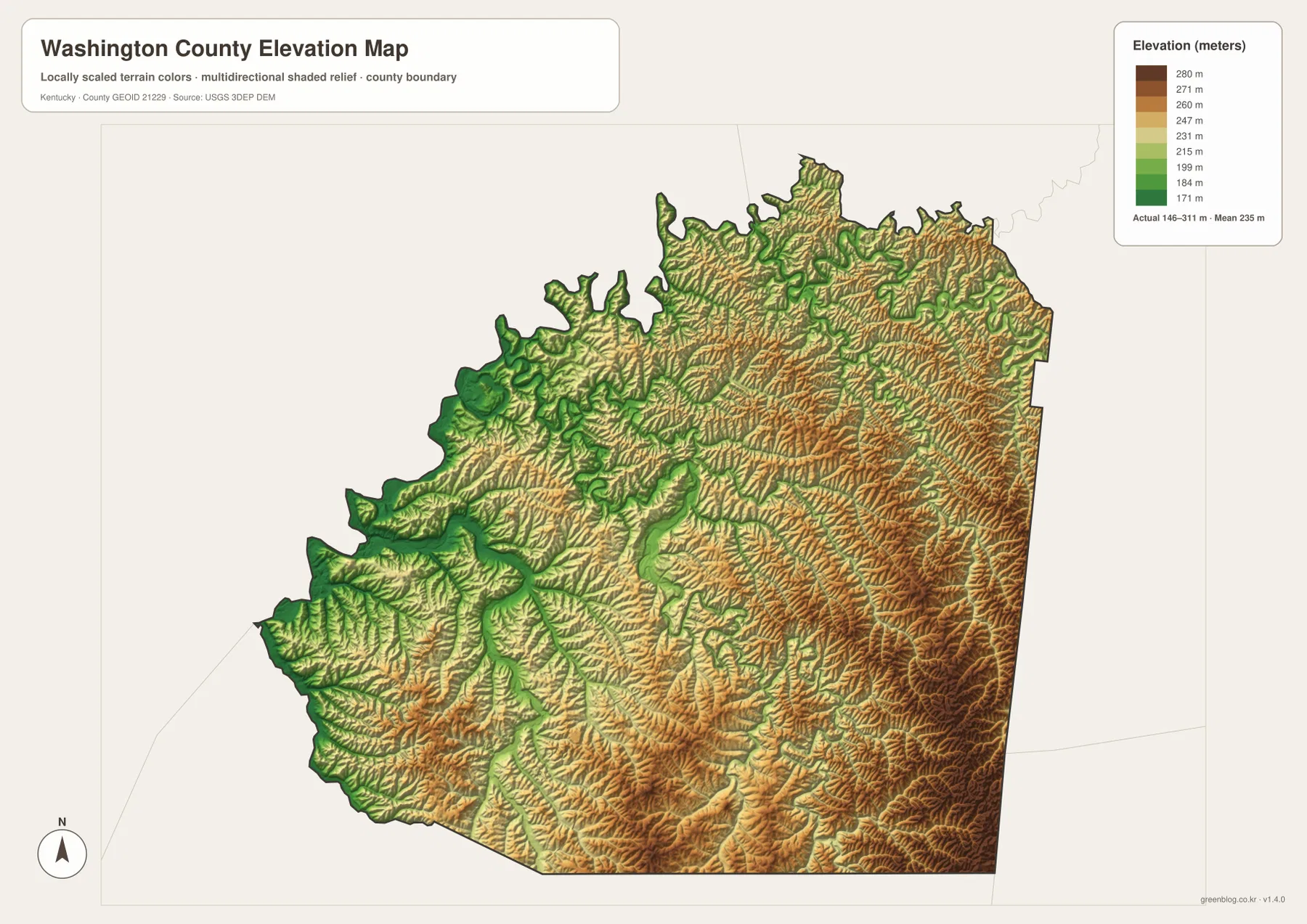
The elevation legend reports an actual county range of about 146 to 311 meters, with a mean near 235 meters. Green marks lower ground, while yellow, orange, and brown indicate progressively higher terrain. The strongest concentrations of higher ridges appear on the eastern and southeastern side, where warm colors cover broad areas cut by narrow green valleys.
Lower corridors follow the larger streams through the center and west. Beech Fork and its tributaries are easy to trace because the surrounding ground drops into elongated green valleys. Chaplin River and the waterways near Willisburg create a similar effect farther north, though the relief there is mixed with many short ridges rather than one broad low plain.
The county’s hills are not arranged as a single mountain mass. Instead, small watersheds divide the land into many narrow ridges, so elevation can change repeatedly over a short distance. That explains the frequent curves on rural roads and the difference between the more open Springfield area and the more rugged-looking east and southeast.
The 146–311 meter range is useful for county-scale comparison, not survey work. Building elevations, bridge grades, road design, and drainage calculations require higher-resolution source data from the USGS 3D Elevation Program and, when necessary, professional field measurements.
Three short comparisons connect the roads, streams, and hills
North from Springfield toward Willisburg, the road map uses KY 55, KY 555, and KY 53 as useful references. The water map adds Chaplin River, Long Lick Creek, and Willisburg Lake, while the elevation map shows low stream corridors alternating with nearby ridges. Seeing those layers together explains why the northern road network contains so many bends.
East toward Mackville, KY 152 and KY 433 help organize the road view. Glenns Creek and other tributaries become more prominent on the water map, and the elevation surface shifts toward higher terrain. The eastern side therefore feels more strongly dissected than the lower valleys farther west.
West toward Manton, KY 150 and KY 605 provide the easiest route references. This side contains broader low valleys and fewer large patches of the highest elevation colors. Comparing all three directions from Springfield gives a better picture of Washington County than treating the county as uniformly rolling farmland.
Choose the Washington County file by the detail you need
The general county map is the strongest starting point for roads, communities, and the boundary. The city map is cleaner for Springfield, Willisburg, and Mackville alone. The terrain-and-water file is the best choice for Chaplin River, Beech Fork, and the named creeks, while the elevation map makes the difference between low valleys and higher eastern ridges much easier to see.
- County map: Use it for Springfield, Willisburg, Mackville, Manton, KY 55, KY 53, KY 152, KY 150, KY 438, KY 433, and the county boundary.
- City map: Use it to compare Springfield with Willisburg at about 10 miles and Mackville at about 9 miles in straight-line distance.
- Terrain and water map: Use it for Chaplin River, Beech Fork, Long Lick Creek, Glenns Creek, Cartwright Creek, Willisburg Lake, and the reservoirs near Springfield.
- Elevation map: Use it to compare the approximately 146–311 meter range, especially higher eastern ridges and lower central and western valleys.
Each original JPG measures 3638 × 2572 pixels in landscape orientation, preserving more small road and creek labels than the web previews. Keeping the original aspect ratio is recommended for printing. If several files are used together, begin with Springfield and the roads, then compare waterways and elevation so the same places remain easy to follow.
Frequently Asked Questions
Which file is best for Springfield, Willisburg, and Mackville?
The city-connections map gives the cleanest quick view. Springfield is the hub, Willisburg is about 10 miles north in straight-line distance, and Mackville is about 9 miles east. For numbered roads and smaller places, use the general county map.
Where can I see Chaplin River and Beech Fork together?
The terrain-and-water map shows both waterways along with Long Lick Creek, Glenns Creek, Cartwright Creek, Willisburg Lake, City Reservoir, and Springfield Reservoir. It is a geographic reference rather than a flood, depth, navigation, or legal-boundary map.
What is the main pattern on the 146–311 meter elevation map?
The east and southeast contain many of the higher ridges, while lower corridors follow Beech Fork, Chaplin River, and other streams through the center and west. The map is useful for regional comparison but not precise enough for construction or survey measurements.
Map File Information
The ZIP contains high-resolution JPG versions of the Washington County general map, city map, terrain-and-water map, and elevation map. Use the previews to check Springfield, the main roads, Chaplin River, Beech Fork, and the 146–311 meter relief before opening the original files.
- Included Files: Use only the versions confirmed in the article and supplied images
- File Type: Use the confirmed download contents
- Intended Use: Printing, education, presentations, and map-based projects
Related Maps
Sources and references
The geographic discussion is based primarily on the supplied Washington County maps, with official county, city, boundary, hydrography, and elevation sources used for context.
- Washington County, Kentucky official website — county government and local history information.
- City of Springfield official website — official city information and community services.
- U.S. Census Bureau TIGER/Line Shapefiles — official geographic boundary and road data.
- USGS National Hydrography — federal hydrography background for rivers, creeks, lakes, and reservoirs.
- USGS 3D Elevation Program — federal elevation and terrain data program.
Green Map creates custom-edited map images using open geographic data sources such as geoBoundaries, Natural Earth, OpenStreetMap, and government open data. These maps are edited visual materials, not raw data files, and are provided for education, documents, presentations, and graphic reference.