Wayne County occupies a rugged part of south-central Kentucky, with Monticello as the main community and road reference, Lake Cumberland spreading across the northwest, and increasingly high ridges toward the south and east. This Wayne County Kentucky Map collection shows Monticello, KY 90, KY 92, KY 167, KY 200, KY 790, the Cumberland River system, and relief ranging from about 212 to 545 meters.
Wayne County’s official site places the county along the Tennessee border and emphasizes its connection to Lake Cumberland. The supplied maps make that setting easy to see: roads gather around Monticello, broad water occupies the northwest, and narrow valleys cut through higher ground across the southern and eastern half. High-resolution JPG copies of the four maps are available together in a downloadable ZIP after the previews.
Table of Contents
Monticello organizes KY 90, KY 92, KY 167, and the local road network
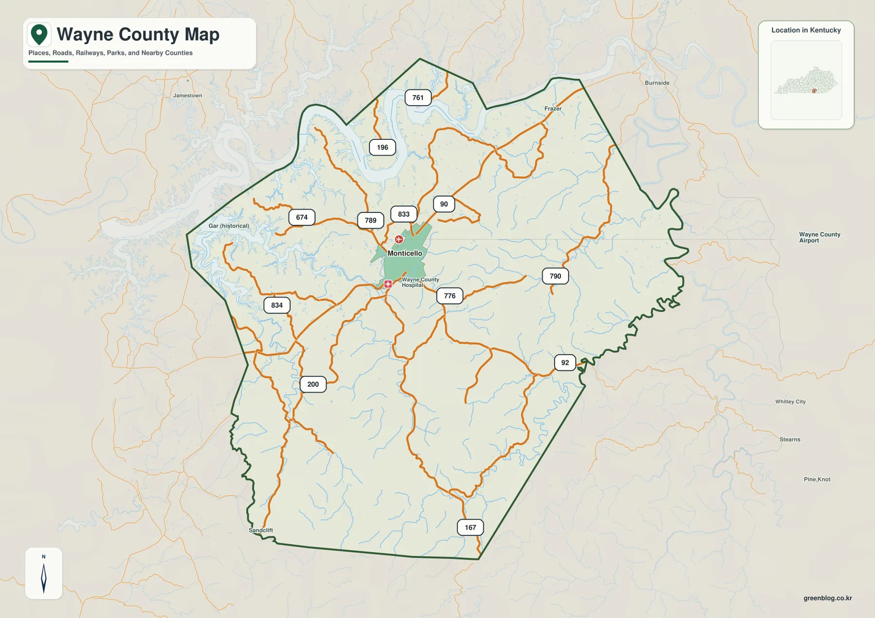
Monticello is the easiest point from which to read the road map. KY 90 crosses the city area and provides a strong east–west reference. KY 92 heads southeast, KY 167 continues south, and KY 200 reaches into the southwestern side. To the east and northeast, KY 790 is another useful route, while KY 833, KY 776, and KY 789 cluster much closer to Monticello.
North of the city, KY 761 and KY 196 lead toward the Lake Cumberland side. KY 674 and KY 834 appear farther west. The closer the roads get to the lake and major valleys, the more frequently they bend around water and steep ground. That pattern contrasts with the tighter web of connections around Monticello.
Jamestown appears to the west, Burnside to the northeast, and Whitley City and Stearns farther east and southeast. Wayne County Airport is marked outside the eastern edge. These labels are useful as external orientation points rather than as a list of communities inside the county. The map itself is a geographic reference, not a live navigation service.
A single major-city marker keeps Monticello easy to locate
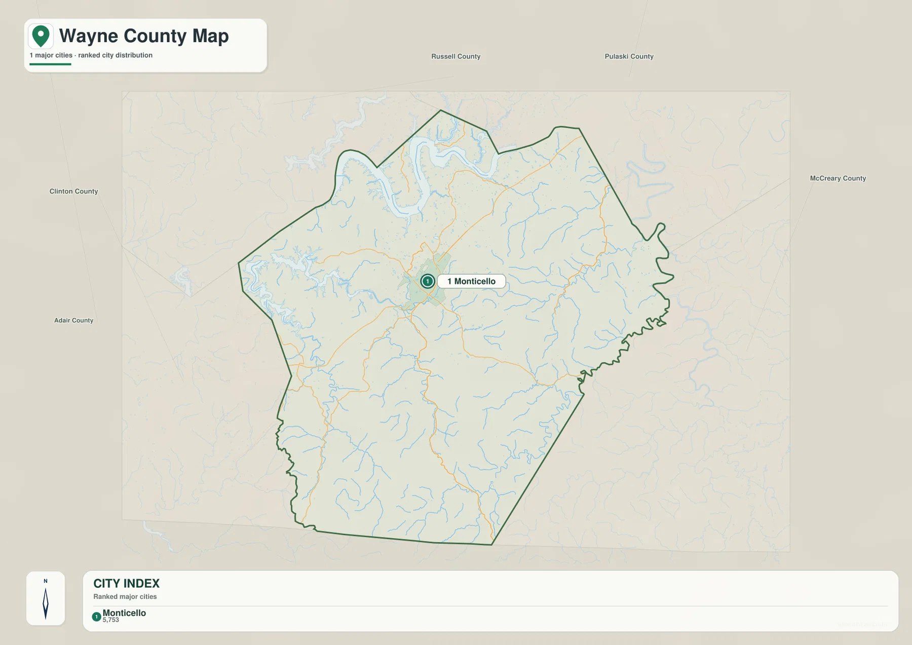
The city map removes most route labels and highlights Monticello as the single major-city reference. The marker sits a little northwest of the county’s visual center, between the Lake Cumberland side and the higher southern uplands. That makes Monticello a convenient anchor before moving to the more detailed road, water, or elevation files.
Russell and Pulaski Counties are shown to the north, McCreary County lies east, and Clinton and Adair Counties appear to the west. The southern side reaches the Tennessee state line rather than another Kentucky county. The number shown in the city index belongs to the source snapshot used for the map and should not be treated as a current official population count.
Lake Cumberland and the Cumberland River dominate the northwestern water landscape
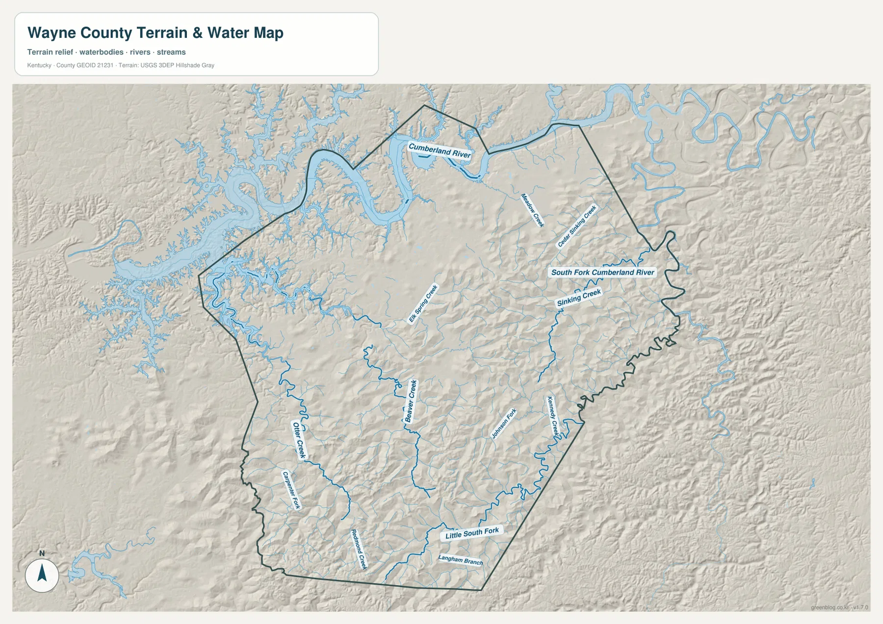
The most striking water feature is the Lake Cumberland and Cumberland River system along the north and northwest. Broad blue water and long branching inlets push into the surrounding ridges, giving this side of the county a much more irregular shoreline than the inland road map might suggest. The lake setting also explains why routes in the northwest have to bend around narrow valleys and water arms.
On the eastern side, South Fork Cumberland River follows a winding corridor near the county boundary. Sinking Creek and several short tributaries drain toward that side. Farther west and through the interior, Elk Spring Creek and Beaver Creek are clearly labeled, while Otter Creek appears toward the southwest.
The southern half contains another group of narrow drainage lines, including Little South Fork, Langham Branch, and Kennedy Creek. These streams occupy low gaps between ridges rather than broad flat plains. The file is designed to show relative water locations, not flood risk, depth, boating routes, fishing regulations, legal shorelines, or parcel ownership.
Relief from 212 to 545 meters separates the lake valleys from the southern uplands
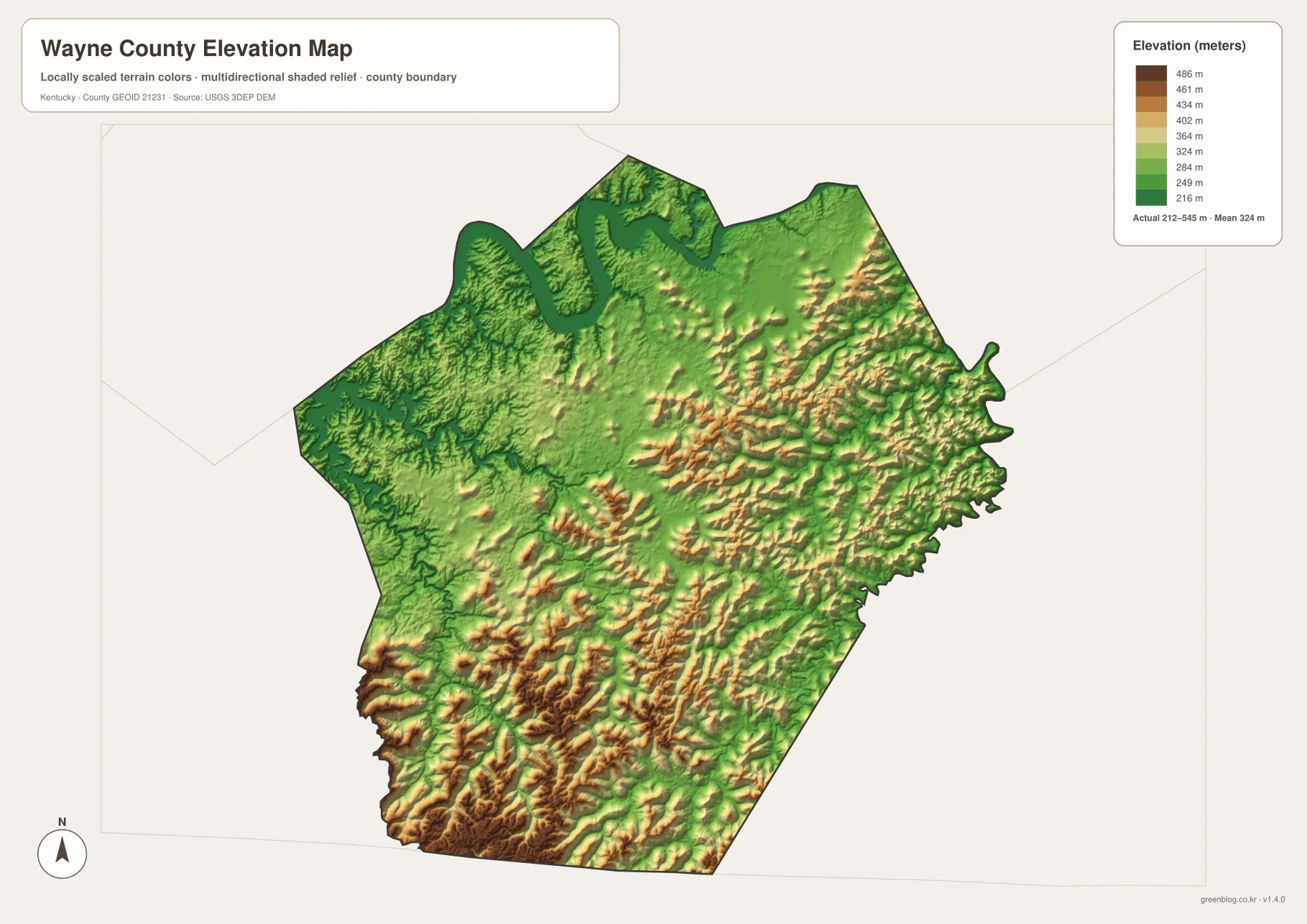
The elevation legend reports an actual county range of about 212 to 545 meters, with a mean near 324 meters. Green shades represent lower ground, while yellow, orange, and brown mark progressively higher terrain. The lowest areas are easiest to trace along Lake Cumberland and the Cumberland River in the north and northwest.
Elevation rises noticeably toward the southern half. Long brown ridges and narrow green valleys repeat across the southwest and south, producing some of the strongest relief on the map. The eastern side is also highly dissected, especially around tributaries leading toward South Fork Cumberland River.
Monticello lies in more moderate terrain than the highest southern ridges, although the area is not flat. Small stream valleys and rounded uplands remain visible around the city. The 212–545 meter range is useful for county-scale comparison, not survey or engineering work.
Three directions from Monticello reveal the county’s strongest contrasts
North from Monticello, KY 761 and KY 196 lead toward Lake Cumberland. The road map emphasizes the routes, the water map introduces broad lake arms and Cumberland River bends, and the elevation file turns those same corridors into low green terrain. This is the clearest transition from the inland road network to the county’s largest water landscape.
South from Monticello, KY 167 and the roads toward KY 200 cross a very different setting. Beaver Creek, Otter Creek, Little South Fork, and other tributaries divide the land into narrow valleys, while the elevation map shows many more brown ridges. East from Monticello, KY 92 and KY 790 point toward South Fork Cumberland River and Sinking Creek.
Choose the Wayne County map that matches the detail you need
The general county map is the strongest starting point for Monticello, numbered roads, and the county outline. The city map is cleaner when the location of Monticello and neighboring counties is all that matters. The terrain-and-water file is best for Lake Cumberland, the Cumberland River system, and named tributaries, while the elevation file shows the 212–545 meter relief most clearly.
- County map: Use it for Monticello, KY 90, KY 92, KY 167, KY 200, KY 761, KY 790, KY 833, KY 834, and the county boundary.
- City map: Use it to place Monticello relative to Russell, Pulaski, McCreary, Clinton, and Adair Counties.
- Terrain and water map: Use it for Lake Cumberland, Cumberland River, South Fork Cumberland River, Sinking Creek, Beaver Creek, Elk Spring Creek, and Little South Fork.
- Elevation map: Use it to compare the approximately 212–545 meter relief, especially low northern water corridors and higher southern and eastern ridges.
Each original JPG measures 3638 × 2572 pixels in landscape orientation, preserving more small road and creek labels than the web previews. Keeping the original aspect ratio is recommended for printing.
Frequently Asked Questions
Which map is best for Monticello, KY 90, KY 92, and KY 167?
The general county map is the best choice because it combines Monticello with KY 90, KY 92, KY 167, KY 200, KY 790, and several smaller routes. It also keeps Lake Cumberland and the county boundary visible for broader orientation.
Where can I see Lake Cumberland and South Fork Cumberland River together?
The terrain-and-water map shows Lake Cumberland, Cumberland River, South Fork Cumberland River, Sinking Creek, Beaver Creek, Elk Spring Creek, Little South Fork, and other tributaries. It is a geographic reference rather than a flood, depth, navigation, or legal-boundary map.
What stands out most on the 212–545 meter elevation map?
The north and northwest contain low valleys around Lake Cumberland and the Cumberland River, while the southern and eastern half has many higher ridges separated by narrow stream valleys. The map is useful for regional comparison but not precise enough for construction, engineering, or survey measurements.
Map File Information
The ZIP contains high-resolution JPG versions of the Wayne County general map, city map, terrain-and-water map, and elevation map. Use the previews to check Monticello, the main road network, Lake Cumberland and Cumberland River waterways, and the 212–545 meter relief before opening the original files.
- Included Files: Use only the versions confirmed in the article and supplied images
- File Type: Use the confirmed download contents
- Intended Use: Printing, education, presentations, and map-based projects
Related Maps
Sources and references
The geographic discussion is based primarily on the supplied Wayne County maps, with official county, city, boundary, hydrography, and elevation sources used for context.
- Wayne County, Kentucky official website — county location, Lake Cumberland, and local government information.
- City of Monticello official website — official city information and local Wayne County context.
- U.S. Census Bureau TIGER/Line Shapefiles — official geographic boundary and road data.
- USGS National Hydrography — federal hydrography background for rivers, creeks, and water features.
- USGS 3D Elevation Program — federal elevation and terrain data program.
Green Map creates custom-edited map images using open geographic data sources such as geoBoundaries, Natural Earth, OpenStreetMap, and government open data. These maps are edited visual materials, not raw data files, and are provided for education, documents, presentations, and graphic reference.