Sedgwick County in south-central Kansas is dominated by Wichita, but the county also includes Derby, Haysville, Bel Aire, Valley Center, Park City, and a wide western rural area. Interstate 135, Interstate 35, US 54/US 400, K-96, and K-254 concentrate around the Wichita metropolitan area. The Arkansas River and Little Arkansas River meet in the city, while the Ninnescah drainage shapes the southern and southwestern countryside. High-resolution map files are available for download in the section below.
This guide follows Wichita and the surrounding communities across the road, water, and elevation views, with terrain ranging from about 369 to 471 meters. WebP previews are available for quick viewing, and the matching high-resolution JPG files can be downloaded together in one ZIP for printing, classroom work, or offline reference.
Table of Contents
Wichita anchors a dense highway network at the center of the county
Wichita is the county’s dominant road and settlement reference. Interstate 135 crosses the urban area from north to south, Interstate 35 serves the southeastern side, and US 54/US 400 forms a major east–west route through the city. K-96 approaches from the northwest and K-254 extends east toward the Butler County side.
Sedgwick County’s official history notes that Wichita was selected as the county seat when county government was organized in 1870. That role is easy to recognize on the modern map because the urban footprint, highways, rail lines, hospitals, universities, and local roads are much more concentrated here than elsewhere in the county.
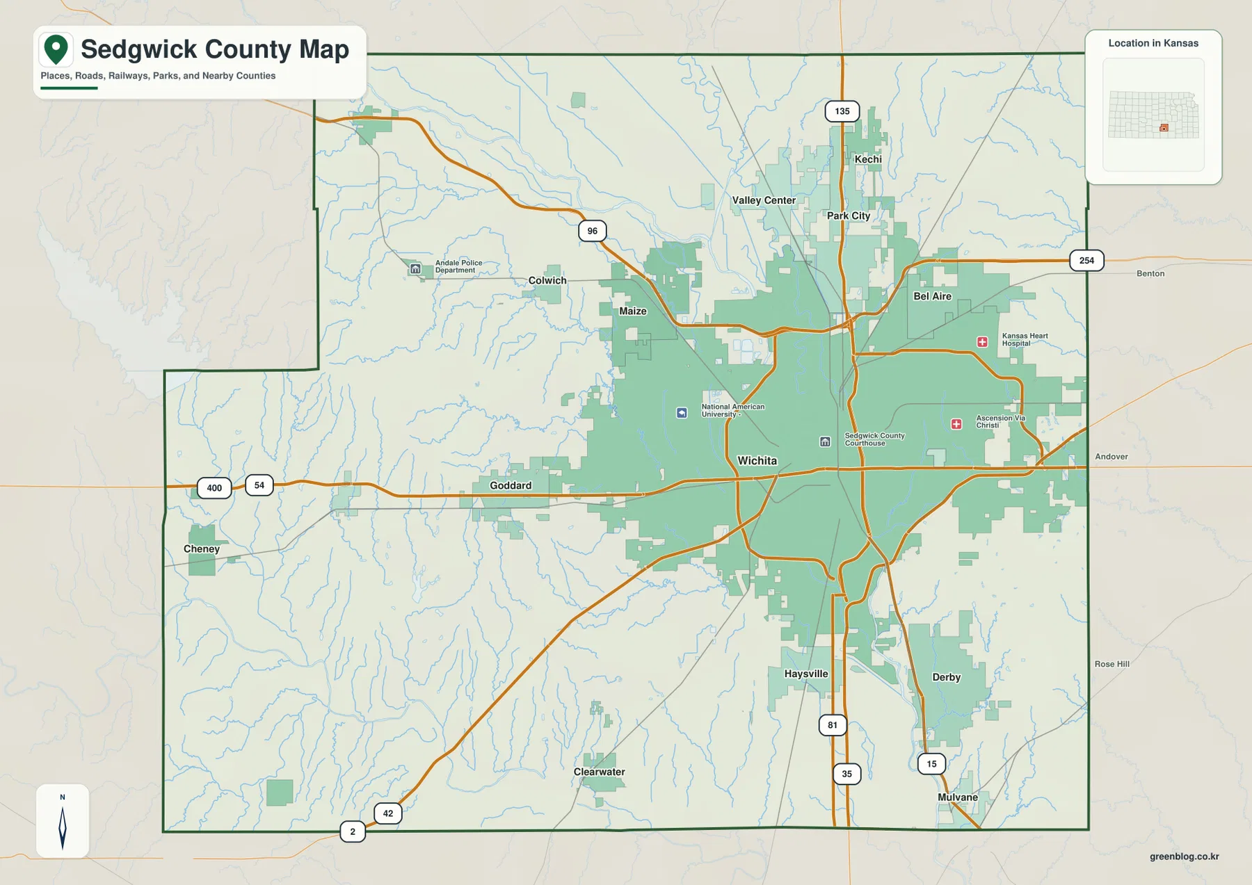
Valley Center, Park City, and Kechi extend the urban pattern north of Wichita, while Bel Aire lies to the east. Derby and Haysville form a strong southern suburban corridor. Goddard and Cheney provide useful references for the much less developed western half of the county.
Wichita overwhelms the six-city index
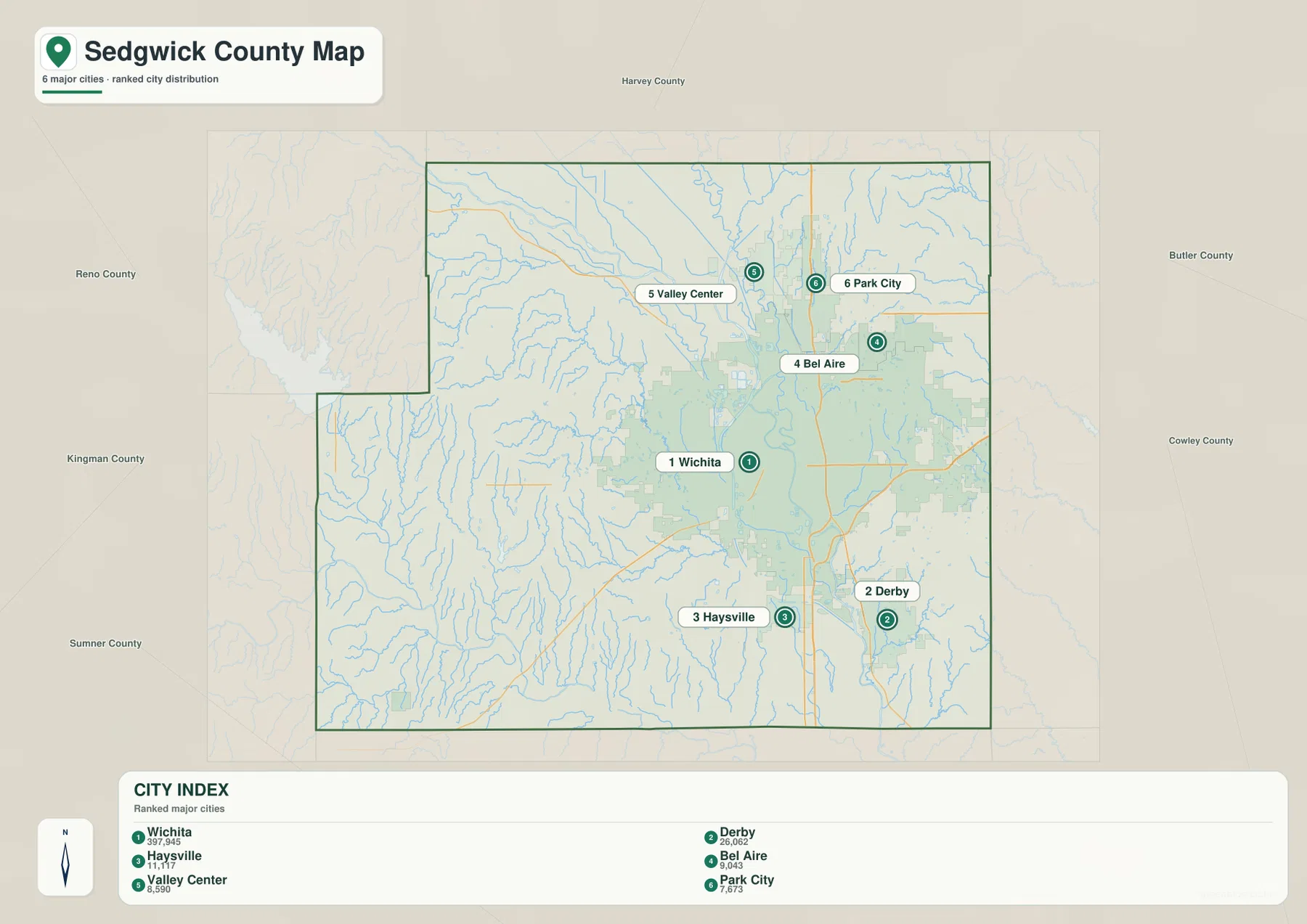
The city panel ranks Wichita at 397,945. Derby follows at 26,062, Haysville at 11,717, Bel Aire at 9,043, Valley Center at 8,590, and Park City at 7,673. These are map index values rather than current official population estimates, but they clearly explain the dramatic difference in marker size between Wichita and the other communities.
The five smaller cities all belong to the broader Wichita area but occupy different settings. Derby and Haysville are south of the city, Bel Aire is east, and Valley Center and Park City are north along the I-135 corridor. Their relationship becomes clearer when the road network and river system are viewed together.
The Kansas Historical Society describes Wichita as the county seat and the largest city in Kansas, with a history tied to cattle trade, milling, and aviation. The official population record and the supplied map index are different datasets, but both reflect Wichita’s outsized role within Sedgwick County.
The Arkansas and Little Arkansas rivers meet inside Wichita
The most important water relationship on the map occurs in Wichita, where the Little Arkansas River flows south from the northern county and joins the Arkansas River. This confluence creates one of the city’s defining geographic landmarks and separates several parts of the urban riverfront.
The City of Wichita places the Keeper of the Plains directly at the confluence of the Big Arkansas and Little Arkansas rivers. The 44-foot sculpture has become a city symbol, but its location is also useful for understanding how the two main rivers fit together on the county water map.
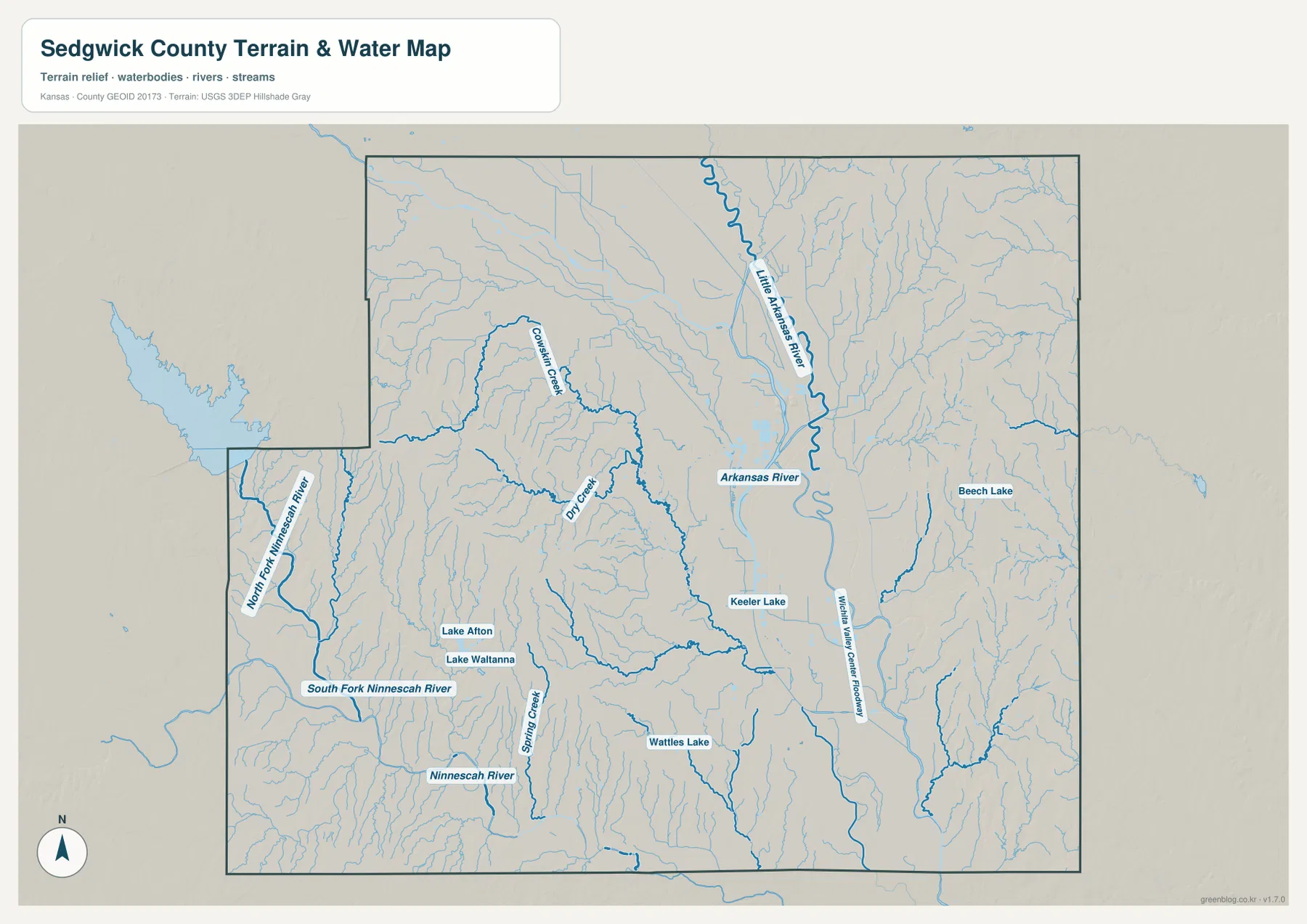
West of Wichita, Cowskin Creek and Dry Creek create long drainage corridors through the rural uplands. The Wichita Valley Center Floodway runs along the eastern side of the main river system, while Beech Lake and Keeler Lake provide smaller urban water references.
Farther southwest, the North Fork Ninnescah River and South Fork Ninnescah River form separate long valleys before contributing to the broader Ninnescah system south of the county. Lake Afton, Lake Waltanna, Wattles Lake, Spring Creek, and numerous short tributaries add detail to the rural water network.
This water image is intended for geographic reference rather than floodplain, navigation, water-quality, parcel, or legal-access decisions. River levels and flood conditions can change, so current agency information should be used whenever safety or property decisions are involved.
Elevation from 369 to 471 meters drops toward Wichita and the major river corridors
The elevation surface ranges from about 369 to 471 meters, with a mean near 415 meters. Higher brown and tan terrain appears across much of the west and northwest, while green lowlands spread through central Wichita and along the Arkansas and Little Arkansas river corridors.
The western edge contains more pronounced uplands cut by Cowskin Creek and numerous smaller channels. Moving toward Wichita, the terrain generally lowers and becomes broader around the main river valleys. That change helps explain why the city’s largest continuous developed area occupies the central lowland.
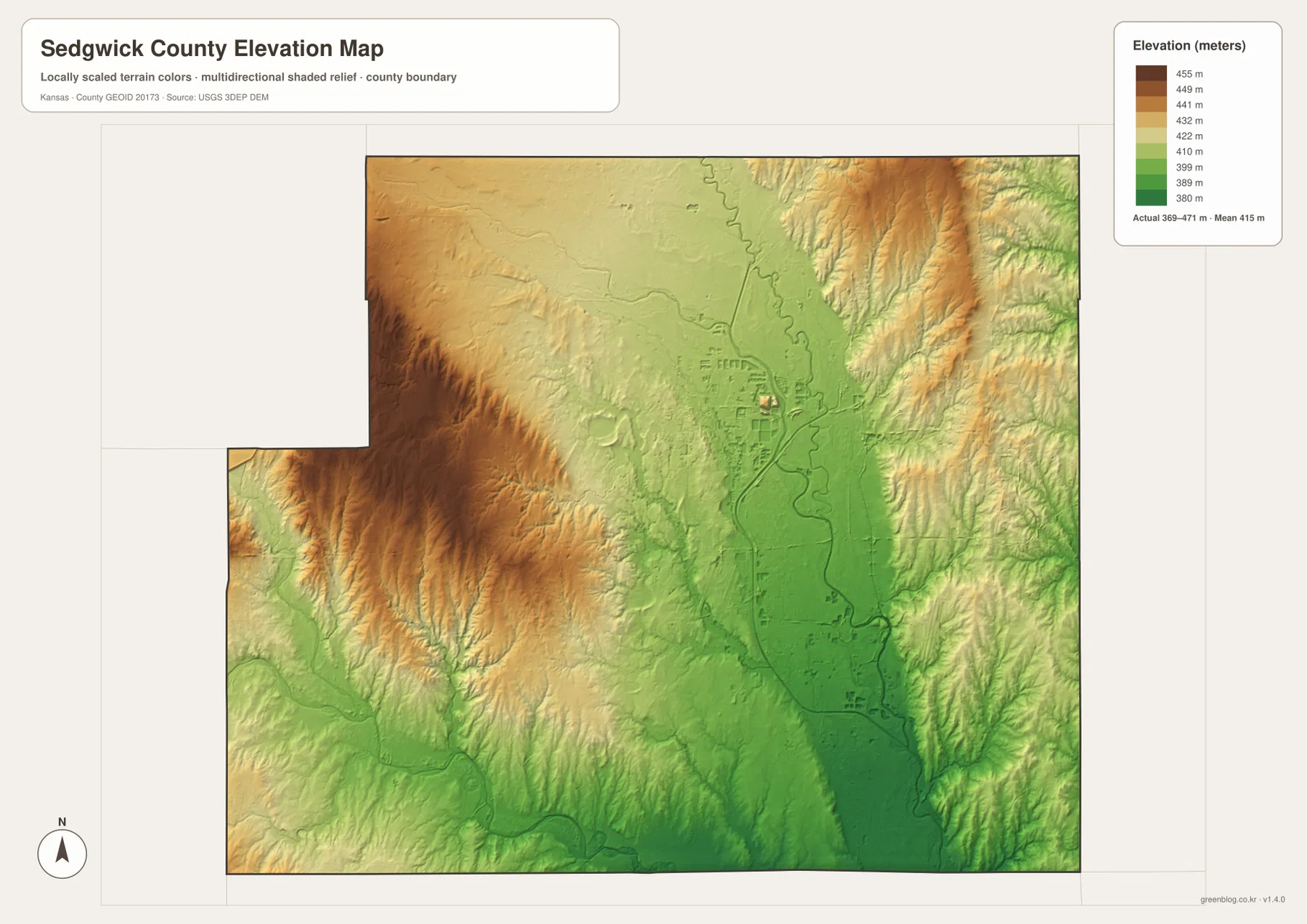
The eastern and northeastern sides rise again into more dissected terrain outside the broad urban lowland. To the southwest, the Ninnescah tributaries cut green valleys through ground that remains higher than the central Wichita river corridor.
The elevation surface is generalized for county-scale comparison. It is not survey-grade or engineering-grade measurement and should not be used for parcel elevations, construction grades, drainage design, or legal boundary work.
Keeper of the Plains connects Wichita’s river geography with local history
The Keeper of the Plains was created by Native American artist Blackbear Bosin and donated to Wichita in 1974. The City of Wichita describes the sculpture as standing at the junction of the Big and Little Arkansas rivers, where it serves as a city symbol and a tribute to Plains Indian culture.
For map readers, the location is especially useful because it turns an abstract confluence into a recognizable place. The Little Arkansas approaches from the north, the Arkansas River continues through the central city, and the riverfront sits in the same low terrain that stands out on the elevation map.
Wichita’s aviation history helps explain the scale of the urban center
The Kansas Historical Society notes that Wichita became known as the “Air Capital of the World” during the twentieth century and connects the city with major aviation names including Cessna, Stearman, and Beech. Aviation joined cattle trade, milling, manufacturing, and transportation in shaping the city’s growth.
The county maps are not industrial-history maps, but the scale of Wichita is impossible to miss. Highways, rail lines, institutions, and developed land occupy a far larger area than any other community, which matches Wichita’s long-standing role as a regional economic center.
Traveling west from Wichita quickly leaves the broad river lowland
US 54/US 400 provides a useful westward cross-section from Wichita through Goddard toward Cheney. The route leaves the broad urban river lowland and enters higher rural terrain cut by Cowskin Creek and many smaller tributaries. The elevation image shows the change much more clearly than the road view alone.
South toward Derby and Haysville, the road network remains dense and the Arkansas River corridor stays close. North toward Valley Center and Park City, the Little Arkansas River and I-135 become the strongest references. These different directions show how one metropolitan area occupies several distinct drainage and elevation settings.
For posters, classroom prints, or presentation slides, use the original JPG files in the download archive rather than enlarging the web previews. Small road labels, creek names, city text, and the elevation legend remain clearer at the higher resolution.
Frequently Asked Questions
Which city is largest on the supplied city index?
Wichita ranks first at 397,945. Derby is 26,062, Haysville 11,717, Bel Aire 9,043, Valley Center 8,590, and Park City 7,673. These are map index values rather than current official population estimates.
Where do the Arkansas and Little Arkansas rivers meet?
They meet in central Wichita. The Keeper of the Plains stands at this confluence, making it one of the easiest real-world landmarks for understanding the county’s main river system.
Can the 369–471 meter elevation image be used for surveying?
No. It is a generalized county-scale terrain image for comparing higher western ground with lower river and creek valleys. Parcel elevations, engineering grades, drainage design, and legal boundary work require more precise official data and, where needed, professional surveying.
Map File Information
The archive contains the Sedgwick County, Kansas general county map, city map, terrain-and-water map, and elevation map as original high-resolution JPG files.
- Included Files: Use only the versions confirmed in the article and supplied images
- File Type: Use the confirmed download contents
- Intended Use: Printing, education, presentations, and map-based projects
Related Maps
Sources and references
- Sedgwick County, Kansas: History — county organization and Wichita county-seat history
- Kansas Historical Society: Sedgwick County, Kansas — Wichita, aviation, regional geography, and local history
- City of Wichita: Keeper of the Plains — Arkansas and Little Arkansas river confluence and landmark information
- U.S. Census Bureau TIGER/Line Shapefiles — county boundary and geographic reference data
- USGS National Hydrography — river and stream reference data
- USGS 3D Elevation Program — elevation and terrain reference data
Green Map creates custom-edited map images using open geographic data sources such as geoBoundaries, Natural Earth, OpenStreetMap, and government open data. These maps are edited visual materials, not raw data files, and are provided for education, documents, presentations, and graphic reference.