Seward County sits in far southwestern Kansas, where Liberal forms the clear urban center and the Cimarron River cuts a deep diagonal valley through the High Plains. US 54 and US 83 meet in Liberal, while Kismet lies much farther northeast along the US 54 corridor. The contrast between broad uplands and the river-cut interior is the county’s strongest geographic feature. High-resolution map files are available for download in the section below.
This guide follows Liberal and Kismet across the road, water, and elevation views, with terrain ranging from about 741 to 913 meters. WebP previews are available for quick viewing, and the matching high-resolution JPG files can be downloaded together in one ZIP for printing, classroom work, or offline reference.
Table of Contents
Liberal anchors the county at the US 54 and US 83 crossroads
Liberal occupies the southwestern part of Seward County, where US 54 crosses the city diagonally and US 83 runs north–south. Rail lines and local streets concentrate around the same urban area, while the northern and western parts of the county quickly transition into sparsely settled agricultural land.
The Kansas Historical Society identifies Liberal as the Seward County seat. The city was established in 1888 and became the county seat in 1892 after earlier settlements had competed for that role. On the modern map, the courthouse area, highway junctions, and urban footprint all reinforce Liberal’s administrative and transportation importance.
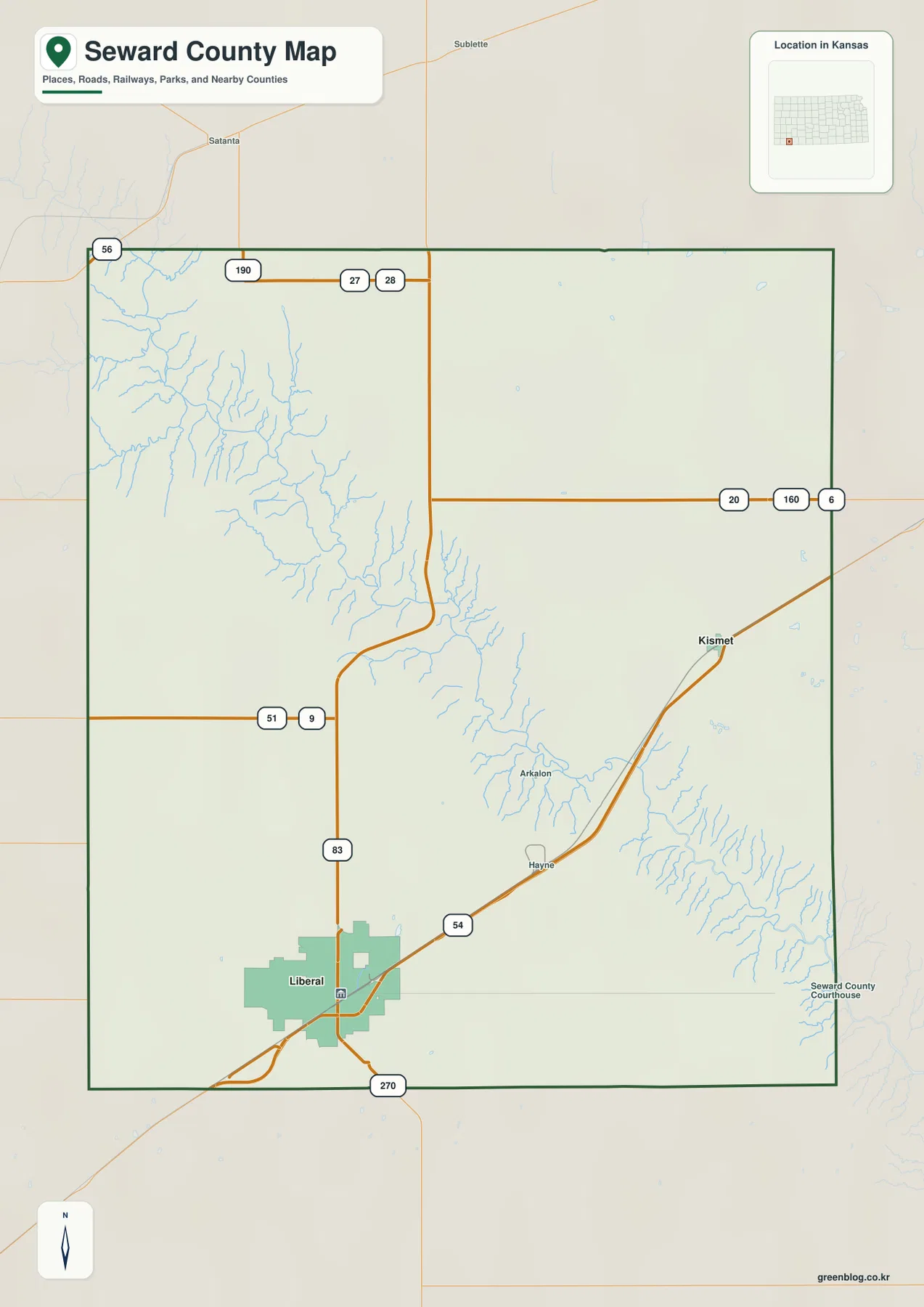
Following US 54 northeast from Liberal brings the route past Hayne and the Arkalon area before reaching Kismet. The landscape between the two cities is mostly rural, and the Cimarron River valley becomes a stronger geographic reference than settlement density.
Only Liberal and Kismet appear on the ranked city panel
The supplied city panel lists Liberal at 19,318 and Kismet at 414. These are map index values rather than current official population estimates, but they show the striking difference in scale between the county’s main city and its small northeastern community.
Liberal occupies a broad urban footprint in the southwest, while Kismet appears as a much smaller settlement near the northeastern side. US 54 provides the most direct road relationship between them, crossing the county’s major river-cut terrain along the way.
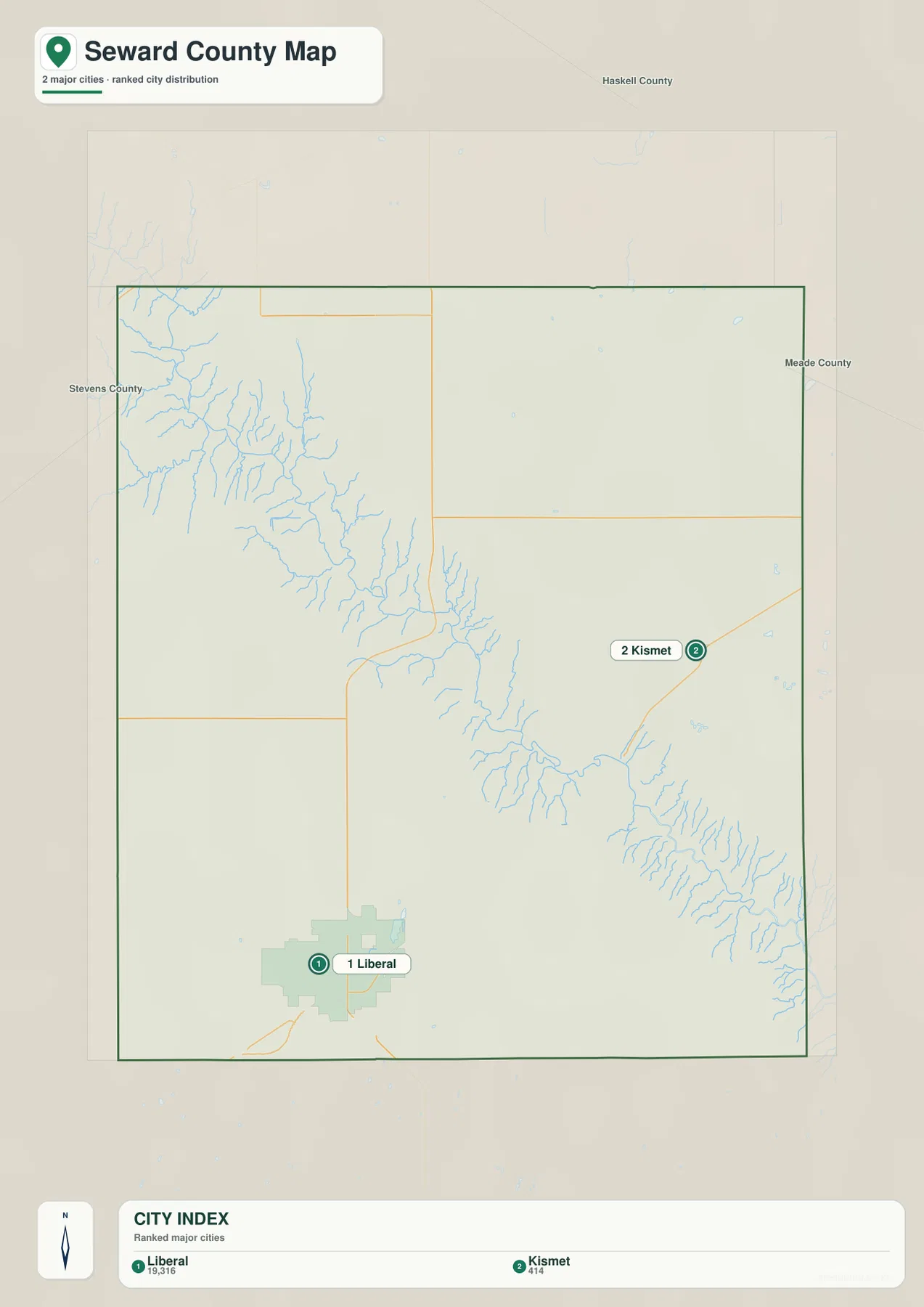
Kansas Historical Society census material also confirms Liberal as by far the county’s largest city. The census population and the supplied index are different datasets and should not be used interchangeably, but both reflect the same highly concentrated settlement pattern.
The Cimarron River carves the county’s defining northwest-to-southeast valley
The Cimarron River is the dominant water feature on the terrain map. It enters from the northwest, cuts diagonally through the county, and exits toward the southeast. Numerous short tributaries descend from both sides, creating a dense branching pattern along the valley walls.
The contrast is especially strong in the northwest, where high plain surfaces are deeply dissected near the main river. Farther southeast, the valley broadens and lower terrain occupies a larger area before the river leaves the county.
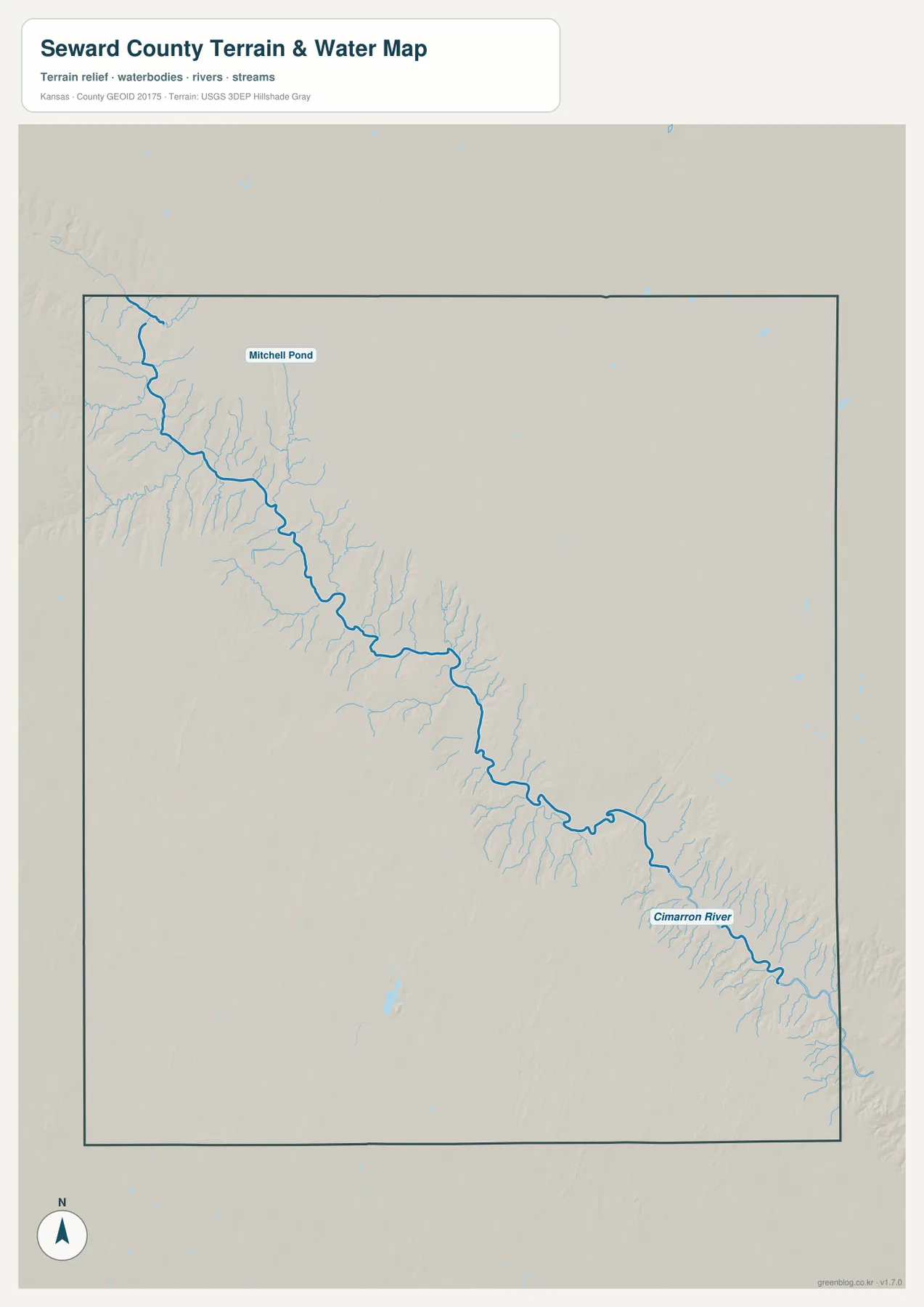
Mitchell Pond appears as a small named water body in the northern part of the county, but no lake or reservoir rivals the Cimarron River as a landscape feature. Seward County is therefore best understood as a broad high plain crossed by one deeply incised river corridor.
This image is intended for geographic reference rather than floodplain, navigation, water-quality, parcel, or legal-access decisions. Cimarron River flow can vary greatly with season and rainfall, so current conditions should be checked before any activity that depends on water level or access.
Elevation from 741 to 913 meters reveals how deeply the river cuts the High Plains
The elevation surface ranges from about 741 to 913 meters, with a mean near 856 meters. Brown high ground dominates the west and northwest, while the Cimarron River appears as a long green low corridor running diagonally toward the southeast. More than 170 meters of local relief separates the highest uplands from the lowest valley floor.
Near the northwestern boundary, tributaries cut sharply into elevated ground and leave narrow ridges between neighboring gullies. The main river valley becomes wider through the middle of the county and reaches its lowest, broadest terrain toward the southeast.
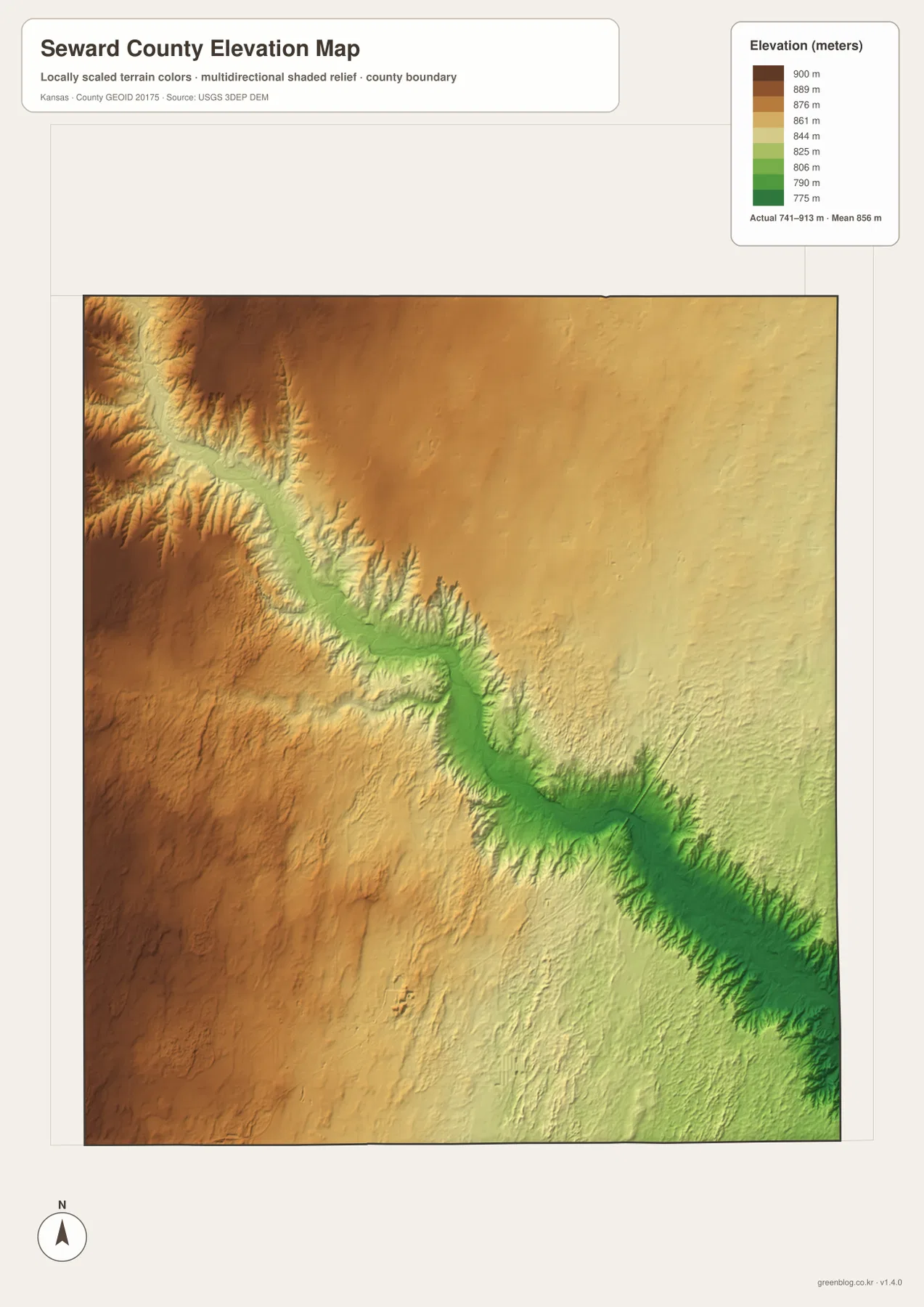
Liberal stands on relatively high plain terrain southwest of the river corridor rather than directly on the deepest valley floor. Kismet lies farther east where the overall land surface is lower, although tributary cuts still create repeated local changes in relief.
The elevation surface is generalized for county-scale comparison. It is not survey-grade or engineering-grade measurement and should not be used for parcel elevations, construction grades, drainage design, or legal boundary work.
Arkalon and the Samson of the Cimarron connect railroad history with the river valley
A Kansas Historical Society marker describes Arkalon as a town founded in 1888 at a railroad crossing of the Cimarron River. The community grew around rail traffic and stockyards, but deep sand, flooding, and later changes to the rail route prevented it from becoming a lasting regional center.
In 1939 the railroad built a 1,269-foot bridge across the Cimarron known as the Samson of the Cimarron. Its story makes the valley more than a physical feature: the same steep, flood-prone corridor visible on the terrain maps directly shaped transportation decisions and the rise and decline of Arkalon.
Dorothy’s House gives Liberal a distinctive cultural identity
Liberal’s Convention and Visitors Bureau promotes Dorothy’s House & Land of Oz as one of the city’s signature attractions. A 1907 farmhouse was restored to evoke Dorothy’s Kansas home, and the adjacent Land of Oz exhibit follows scenes associated with the classic story.
The attraction is not a terrain feature, but it provides an unmistakably local reference for readers locating Liberal on the county map. It also shows how the county’s identity extends beyond agriculture and transportation into tourism and popular culture.
The route from Liberal to Kismet crosses the county’s strongest terrain break
Traveling northeast from Liberal on US 54 begins on broad High Plains terrain. Near the Arkalon and Hayne area, the road approaches the Cimarron River corridor, where the elevation map shows a dramatic drop into deeply dissected low ground.
Beyond the river country toward Kismet, the surface becomes more open again, although the eastern side remains lower overall than the highest western uplands. Comparing the road, water, and relief views together makes this cross-county transition much easier to understand.
For posters, classroom prints, or presentation slides, use the original JPG files in the download archive rather than enlarging the web previews. Small road labels, place names, tributaries, and the elevation legend remain clearer at the higher resolution.
Frequently Asked Questions
Why does the city map show only Liberal and Kismet?
The supplied ranked-city dataset contains two entries for Seward County: Liberal at 19,318 and Kismet at 414. Smaller place names can still appear on the general county map, but only these two communities are included in the city ranking panel.
What is the county’s most distinctive terrain feature?
The Cimarron River valley is the strongest feature. It cuts diagonally from northwest to southeast through the High Plains, with many short tributaries carving steep side valleys into the surrounding uplands.
Can the 741–913 meter elevation image be used for surveying?
No. It is a generalized county-scale terrain image for comparing high plains with the lower Cimarron River valley. Parcel elevations, engineering grades, drainage design, and legal boundary work require more precise official data and, where needed, professional surveying.
Map File Information
The archive contains the Seward County, Kansas general county map, city map, terrain-and-water map, and elevation map as original high-resolution JPG files.
- Included Files: Use only the versions confirmed in the article and supplied images
- File Type: Use the confirmed download contents
- Intended Use: Printing, education, presentations, and map-based projects
Related Maps
Sources and references
- Kansas Historical Society: Seward County, Kansas — county seat, county history, and census information
- Kansas Historical Society: Kansas Historical Markers — Arkalon, Samson of the Cimarron, Fargo Springs, and Springfield history
- Visit Liberal: Dorothy’s House & Land of Oz — Liberal attraction and tourism information
- U.S. Census Bureau TIGER/Line Shapefiles — county boundary and geographic reference data
- USGS National Hydrography — river and stream reference data
- USGS 3D Elevation Program — elevation and terrain reference data
Green Map creates custom-edited map images using open geographic data sources such as geoBoundaries, Natural Earth, OpenStreetMap, and government open data. These maps are edited visual materials, not raw data files, and are provided for education, documents, presentations, and graphic reference.