Shawnee County in northeastern Kansas combines a large state-capital city with broad river lowlands and hillier rural terrain. Topeka dominates the eastern-central part of the county, while Silver Lake, Rossville, Auburn, and Willard provide smaller references around the Kansas River and southern uplands. Interstate 70, US 40, and US 75 concentrate around Topeka, making the county’s road pattern as distinctive as its river valleys. High-resolution map files are available for download in the section below.
This guide follows Topeka and the surrounding communities across the road, water, and elevation views, with terrain ranging from about 254 to 393 meters. WebP previews are available for quick viewing, and the matching high-resolution JPG files can be downloaded together in one ZIP for printing, classroom work, or offline reference.
Table of Contents
Topeka anchors the county just south of the Kansas River
Topeka sits in the eastern-central part of Shawnee County. Interstate 70 and US 40 cross the northern side of the city, while US 75 runs north–south through the urban area. K-4 approaches from the west and K-335 provides a useful route toward Auburn in the southwest. Rail lines and local roads are also most concentrated in the Topeka area.
The Kansas Historical Society identifies Topeka as both the Shawnee County seat and the capital of Kansas. Topeka became the county seat in 1858, and the city’s government and institutional role helps explain the large urban footprint visible on the map.
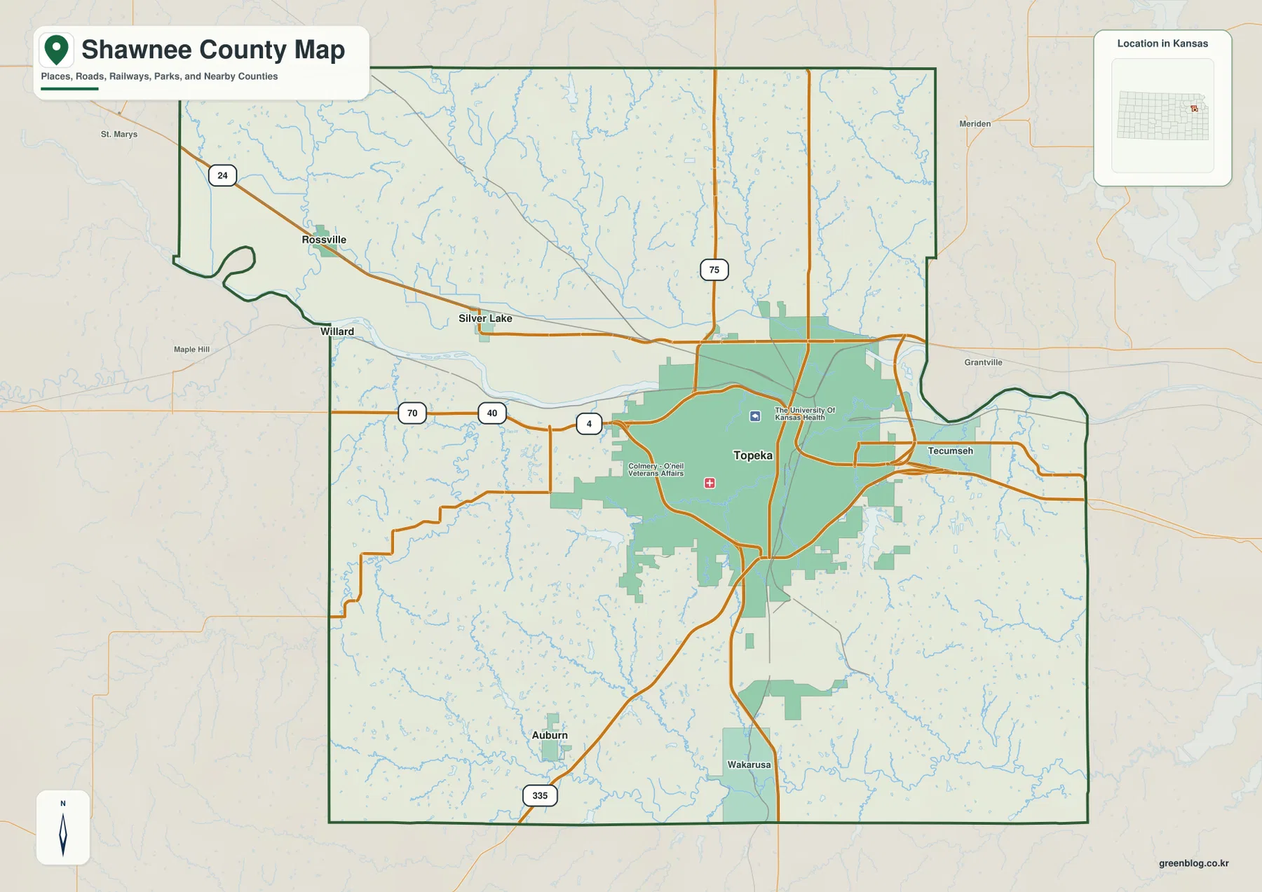
Silver Lake and Rossville lie west and northwest of Topeka near the Kansas River and US 24 corridor. Willard sits near a large bend in the river, while Auburn is farther south in much hillier rural terrain. Tecumseh provides an eastern reference where the Topeka urban area approaches the river corridor.
Topeka is the clear hub on the city-connections map
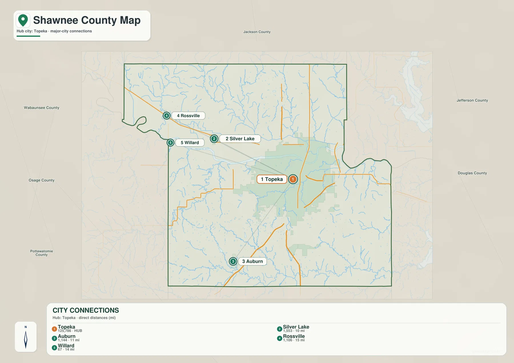
The city-connections panel lists Topeka at 125,786. Silver Lake is 1,553 and about 10 direct miles away, Auburn is 1,144 and about 11 miles, Willard is 67 and about 14 miles, and Rossville is 1,106 and about 15 miles from the hub.
These are map index values rather than current official population estimates, and the mileages are straight-line distances rather than driving distances. Silver Lake and Rossville belong to the western Kansas River corridor, while Auburn occupies a very different setting in the southern uplands.
Kansas Historical Society census information also shows Topeka as by far the county’s largest city. The census figures and the supplied map index are different datasets and should not be treated as interchangeable, but both reflect the same settlement pattern.
The Kansas River forms the county’s broad central lowland
The Kansas River is the strongest water feature on the map. It enters from the west in a broad looping channel, passes north of Topeka, and continues toward the eastern boundary. Its valley is wider and lower than most of the surrounding terrain, creating a clear geographic divide across the middle of the county.
Mission Creek drains a large part of the southwestern and western Topeka area toward the Kansas River. Shunganunga Creek crosses the eastern side of Topeka and approaches the river farther east. Along the southern boundary, the Wakarusa River creates a separate low corridor with several branches feeding it from the uplands.
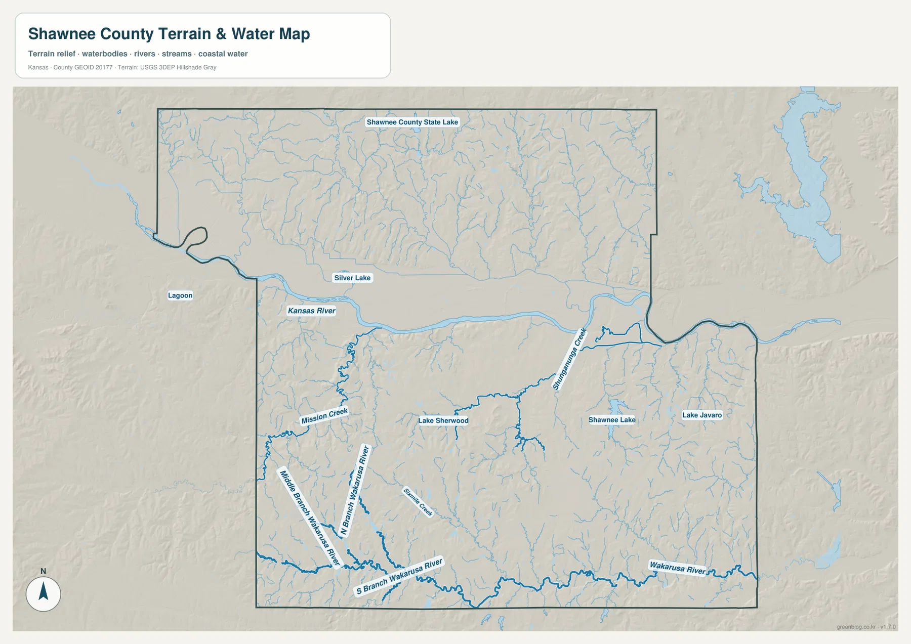
The North, Middle, and South Branches of the Wakarusa River divide the southwestern hills before reaching the larger southern river. Lake Sherwood lies southwest of Topeka, while Shawnee Lake and Lake Jivaro provide smaller water references east and southeast of the city.
This water image is intended for geographic reference rather than floodplain, navigation, water-quality, parcel, or legal-access decisions. River and lake conditions can change, so current agency information should be used whenever access, flooding, or safety matters.
Elevation from 254 to 393 meters rises sharply away from the main river valley
The elevation surface ranges from about 254 to 393 meters, with a mean near 308 meters. The Kansas River appears as a long dark-green lowland through the middle of the county, while higher tan and brown hills occupy much of the southwest and northern interior.
Around Auburn, the terrain is noticeably more rugged, with short tributaries cutting through higher ridges. The northern half also contains many closely spaced creek valleys. In contrast, the Kansas River corridor around Topeka and Silver Lake is broad, low, and relatively smooth.
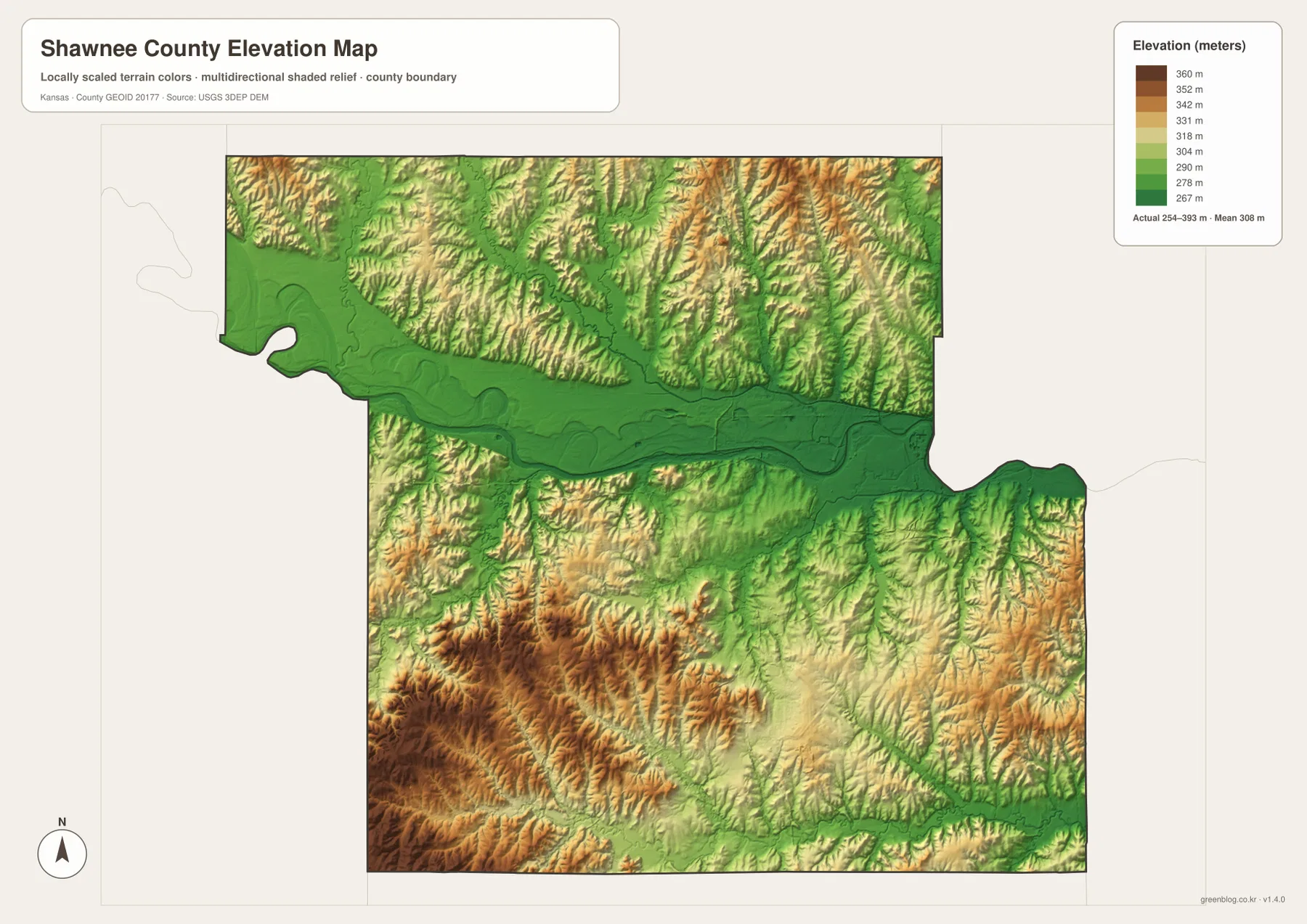
The Wakarusa River forms another green lowland near the southern boundary. Between the Kansas and Wakarusa valleys, rolling ground covers much of the central and southern county, so Shawnee County is not simply one flat river plain.
The elevation surface is generalized for county-scale comparison. It is not survey-grade or engineering-grade measurement and should not be used for parcel elevations, construction grades, drainage design, or legal boundary work.
Lake Shawnee provides an important recreation landmark east of Topeka
Shawnee County Parks + Recreation describes Lake Shawnee as a major local recreation destination. The lake was developed as a Works Progress Administration project beginning in 1935 and was completed in 1939. Today the site supports walking, camping, fishing, boating, gardens, sports, and community events.
On the county water map, Shawnee Lake sits southeast of central Topeka. It is much smaller than the Kansas or Wakarusa river systems, but its location makes it one of the easiest local water landmarks to connect with the metropolitan area.
Topeka’s capital-city role gives Shawnee County an unusual mix of urban and rural land
The Kansas Historical Society notes that Topeka is both the state capital and the Shawnee County seat. State government, major institutions, schools, and public facilities occupy the same county that also contains small towns, farms, and deeply cut rural creek valleys.
The Oregon Trail also crossed Shawnee County, adding another layer to the county’s transportation history. The modern map does not trace the historic trail, but the Kansas River corridor and long-established east–west travel routes help explain why this area has been important for movement across northeastern Kansas.
A trip from Rossville through Topeka toward Auburn crosses two very different landscapes
Rossville and Silver Lake sit close to the low Kansas River corridor west of Topeka. Moving south from the city toward Auburn leaves that broad valley and enters higher, more dissected terrain where Mission Creek and Wakarusa tributaries cut into the hills.
East toward Tecumseh, the Kansas River remains an important lowland reference, while the southeastern county becomes more strongly influenced by the Wakarusa drainage. Comparing roads, water, and elevation together makes these changes much easier to see.
For posters, classroom prints, or presentation slides, use the original JPG files in the download archive rather than enlarging the web previews. Small road labels, creek names, community text, and the elevation legend remain clearer at the higher resolution.
Frequently Asked Questions
Which listed community is closest to Topeka on the city-connections map?
Silver Lake is shown about 10 direct miles from Topeka. Auburn is about 11 miles away, Willard about 14, and Rossville about 15. These are straight-line distances rather than driving distances.
Are the Kansas River and Wakarusa River the same river?
No. The Kansas River crosses the middle of the county, while the Wakarusa River follows a separate corridor near the southern boundary. Mission Creek and several Wakarusa branches drain the higher terrain between them.
Can the 254–393 meter elevation image be used for surveying?
No. It is a generalized county-scale terrain image for comparing low river valleys with higher hills. Parcel elevations, engineering grades, drainage design, and legal boundary work require more precise official data and, where needed, professional surveying.
Map File Information
The archive contains the Shawnee County, Kansas general county map, city-connections map, terrain-and-water map, and elevation map as original high-resolution JPG files.
- Included Files: Use only the versions confirmed in the article and supplied images
- File Type: Use the confirmed download contents
- Intended Use: Printing, education, presentations, and map-based projects
Related Maps
Sources and references
- Kansas Historical Society: Shawnee County, Kansas — county seat, state capital, Oregon Trail, and county history
- Shawnee County Parks + Recreation: Lake Shawnee — lake history and recreation information
- U.S. Census Bureau TIGER/Line Shapefiles — county boundary and geographic reference data
- USGS National Hydrography — river and stream reference data
- USGS 3D Elevation Program — elevation and terrain reference data
Green Map creates custom-edited map images using open geographic data sources such as geoBoundaries, Natural Earth, OpenStreetMap, and government open data. These maps are edited visual materials, not raw data files, and are provided for education, documents, presentations, and graphic reference.