Harrison County sits in East Texas with Marshall near the middle of the county and a clear east-west chain of communities along the I-20 corridor. Hallsville lies to the west, Waskom near the eastern edge, Scottsville just east of Marshall, and Nesbitt to the northwest. The maps on this page are useful because they separate several kinds of information that become crowded on a single image: county roads and places, ranked communities, waterways, and elevation.
If you came here mainly for the files, you can download the original A3 high-resolution JPG maps as one ZIP from the map file box below. For reading the county first, start with Marshall and I-20, then compare the city map with the water and elevation maps. That sequence makes it easier to see why the western hills, southern Sabine River drainage, and lake-rich northern edges look different from one another.
The county is crossed by many small streams, and its terrain is more broken than a simple flat-road map suggests. The county map makes the transportation pattern easy to follow, while the water map reveals how creeks cut through the interior. The elevation map then adds another layer by showing a real range of about 51 to 182 meters, with an average near 92 meters.
Table of Contents
Marshall at the Center of the I-20 Corridor
Marshall is the easiest starting point on the county map because several major routes meet around it. Hallsville appears west of Marshall on the route toward Longview, while Scottsville and Waskom extend the settlement pattern eastward. Nesbitt sits northwest of Marshall, and the small community of Uncertain occupies the northeastern projection of the county. These positions make the county easier to understand when Marshall is used as the central reference rather than when the boundary is viewed by itself.
I-20 is the strongest east-west road shown on the map. It runs from the Hallsville side across the county south of central Marshall and continues toward Waskom. U.S. 59 crosses the county north to south through Marshall, while Texas 43 branches northward and southeastward. Texas 154 appears across the northwestern part of the county, and U.S. 281 is marked near the southwest side. Together these routes show why Marshall is the most useful orientation point for both local and through travel.
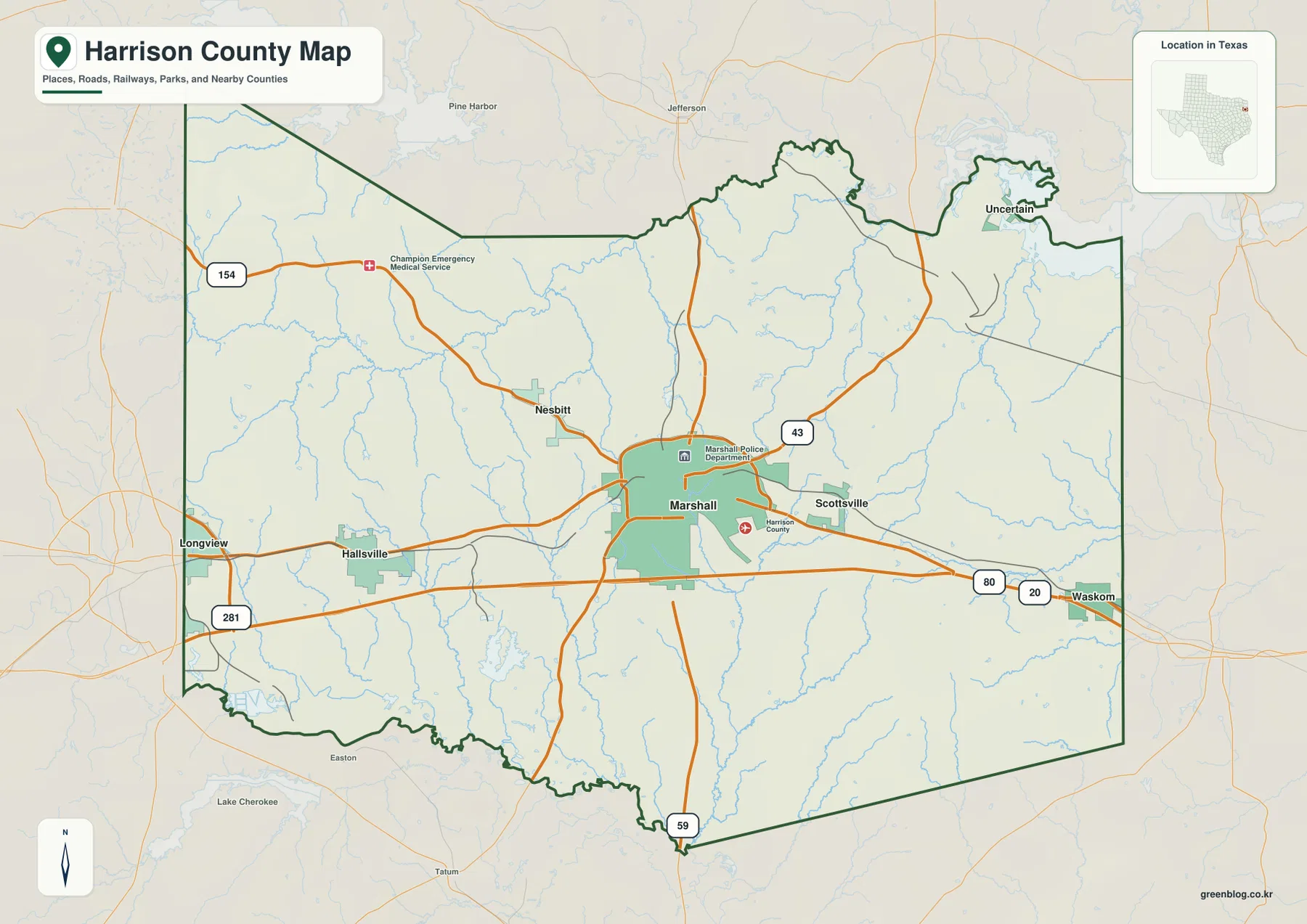
Neighboring counties provide additional orientation. Gregg County and Longview are shown to the west, Rusk County to the southwest, and Panola County to the south. Marion County lies to the north, while Upshur County is labeled beyond the northeastern side. Waskom is close to the eastern edge of Harrison County, so it works as a useful reference when comparing the county interior with travel toward the state line.
What the Six-Place City Index Shows
The city-distribution map ranks six places and strips away much of the road detail. Marshall is ranked first near the center. Hallsville is second on the western side, and Waskom is third near the eastern boundary. Scottsville is shown east of Marshall, Nesbitt to the northwest, and Uncertain in the northeastern extension of the county. This arrangement makes the relative spacing of the communities much easier to compare than on the busier county map.
The index also makes the difference in community size visible. Marshall is clearly the largest place in the list, with Hallsville and Waskom following at a much smaller scale. Scottsville, Nesbitt, and Uncertain appear as still smaller communities. Those rankings should not be treated as a map of service areas or municipal influence, but they are useful for seeing which named places dominate the county’s settlement pattern and which ones act mainly as small geographic reference points.
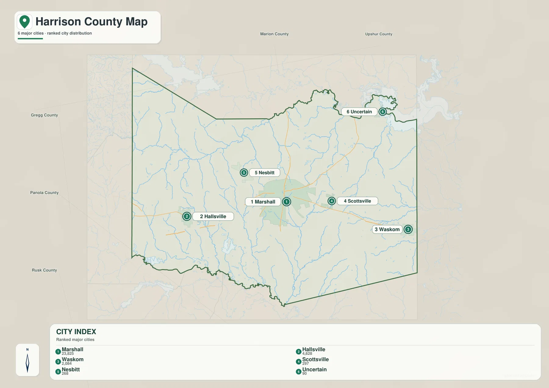
When connector lines appear on the city map, they are best read as straight-line comparisons between place locations, not as driving routes. Actual travel distance can be longer because roads bend around creeks, intersections, and other terrain. Use the city map for direction and spacing, then return to the county map when you need the road network itself.
From Longview to Waskom Across Harrison County
The western and eastern sides of Harrison County feel closely connected on the road map because I-20 carries a continuous route through Hallsville, the Marshall area, and Waskom. U.S. 59 provides the strongest north-south crossing through Marshall, while Texas 43 and Texas 154 serve different parts of the county. The pattern is dense around the central and southern settlement corridor and becomes more lightly marked in areas where small streams and rural roads dominate the map.
Hallsville is especially useful for understanding the western side because it lies between Longview and Marshall. Waskom plays a similar orientation role on the eastern edge. North of the I-20 belt, the map shows fewer large community labels and many more small drainage lines. South of the main corridor, roads continue toward the county boundary but pass through a landscape where creeks become increasingly important visual features.
Sabine River, Little Cypress, and a Dense Creek Network
The terrain-and-water map changes the emphasis completely. The Sabine River is labeled along the southwestern edge, while Little Cypress crosses the western interior. Potters Creek runs southward through the central-western part of the county, and Eighteenmile Creek is prominent farther east. Quapaw Creek and Caney Creek appear in the southeast. Numerous smaller blue lines fill the spaces between them, making the drainage network one of the most distinctive features of this map.
Water bodies are also important around the county’s edges and interior. Lake O’ the Pines is visible beyond the northwestern boundary, while Holmes Lake, Shadowood Lake, Fern Lake, and Highland Lake are labeled inside the county. Brandy Branch Cooling Pond and Darco Lake appear in the south. Harrison Bay is marked toward the east, where large waters reach close to the county boundary. The map therefore shows several different water settings rather than one single river corridor.
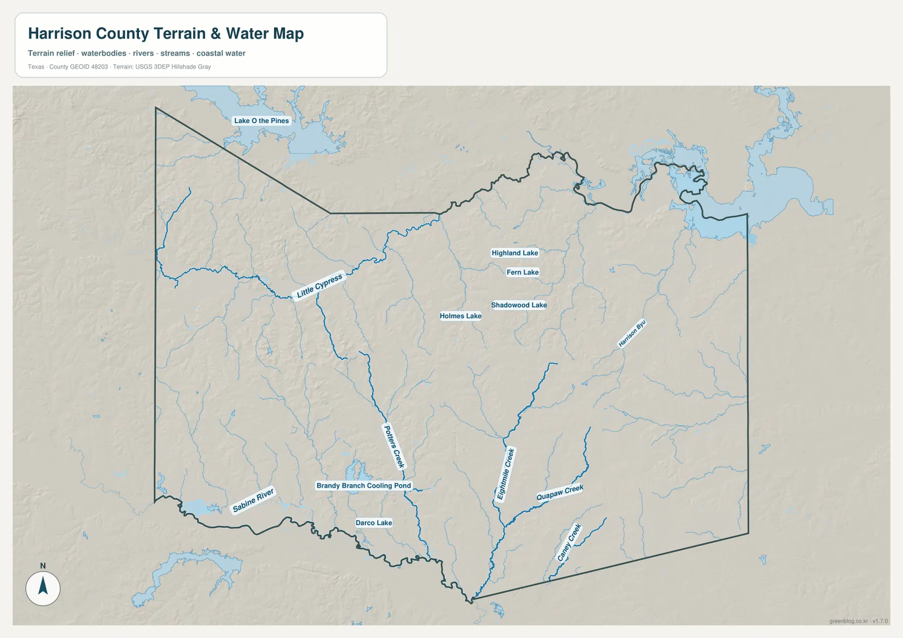
This is a location reference for rivers, creeks, ponds, and lakes. It is not a flood-hazard map, property-boundary product, or navigation chart, and it does not show channel depth or current access conditions. For this page, its main value is seeing how water is distributed across the county and how the major creeks lead toward lower terrain in the south and east.
Higher Western Hills and Lower Stream Valleys
The elevation map reports an actual county range of roughly 51 to 182 meters, with a mean near 92 meters. Browns and warm tan colors are strongest across the west and southwest, where the surface is cut by many short ridges. Greens follow lower areas around streams and become more common toward parts of the north, east, and southern drainage corridors. The county is not mountainous, but the shaded relief makes the repeated rise-and-fall of the terrain very clear.
The western side is especially textured, with narrow ridges separated by creek valleys. Similar relief continues through the center, although lower green corridors become easier to trace where water drains toward the southern boundary. In the northeast, lower terrain is visible near the large water bodies. Comparing this map with the water map helps explain why so many creeks occupy the low strips between the higher ridges.
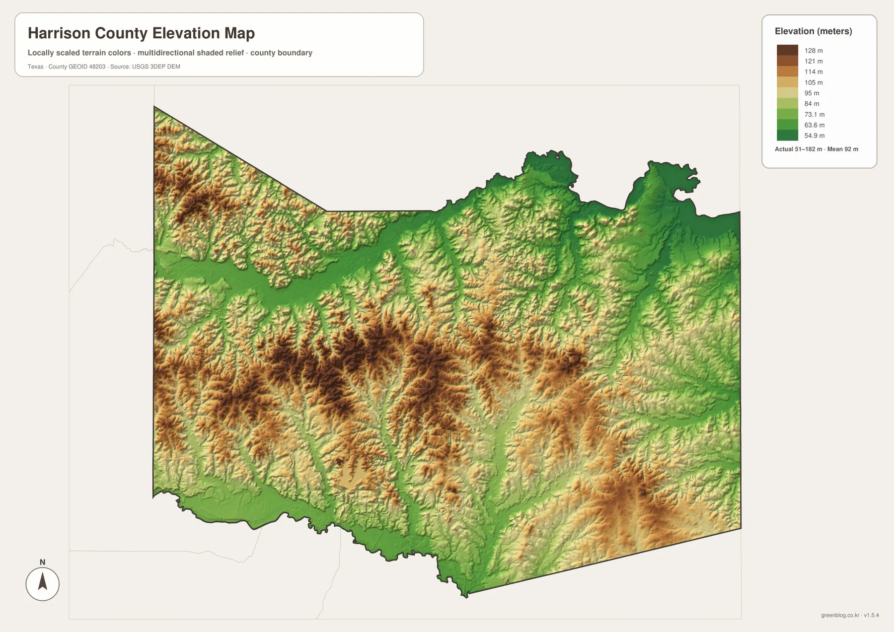
The elevation surface is generalized for county-scale viewing. It should not be used as a survey-grade height for a parcel, building site, road design, or engineering decision. It is most useful for comparing broad relative elevation: higher ridges in the west and interior, and lower ground associated with stream valleys and large water bodies.
Choosing the Right Map for a Harrison County Question
Use the county map when your main question is where a town sits in relation to I-20, U.S. 59, or another major route. It is the best choice for locating Marshall, Hallsville, Waskom, and nearby communities within the boundary. The city-distribution map is simpler when you only need to compare the ranked places and their relative direction from Marshall.
For the Sabine River, Potters Creek, Eighteenmile Creek, Lake O’ the Pines, or the smaller lakes, the water map is much easier to read. The elevation map is the better choice when you want to compare the western ridges with lower drainage corridors. Using the maps separately keeps each task clear instead of forcing roads, city labels, water, and relief into one crowded view.
The WebP images in the article are sized for convenient on-screen reading, while the ZIP contains the larger original JPG files. That makes it possible to use the county and city maps for printed location work, the water map for river and creek references, and the elevation map for a clear county-scale terrain comparison.
Frequently Asked Questions
Where should I start when reading a Harrison County map?
Start with Marshall near the center and follow I-20 west toward Hallsville and east toward Waskom. Then locate U.S. 59 through Marshall and compare Nesbitt to the northwest and Scottsville to the east. That sequence gives you a quick framework for the rest of the county.
Which map is best for the Sabine River and Harrison County creeks?
The terrain-and-water map is the clearest choice. It labels the Sabine River, Little Cypress, Potters Creek, Eighteenmile Creek, Quapaw Creek, Caney Creek, and several lakes. It is intended for location comparison, not for flood risk, water depth, navigation, or parcel decisions.
What elevation range is shown for Harrison County?
The elevation legend gives an actual range of about 51 to 182 meters and a mean near 92 meters. Higher terrain is especially visible in the west and southwest, while lower colors commonly follow creek valleys and water bodies. These values are for county-scale comparison rather than site surveying.
Sources and Reference Data
For official county boundaries, roads, and place layers, see the U.S. Census Bureau TIGER/Line Shapefiles.
Official river, creek, and lake reference data are available through USGS National Hydrography.
Elevation program information and 3DEP documentation are available from the USGS 3D Elevation Program.
For a broader interactive view of U.S. topographic and geographic layers, use USGS The National Map Viewer.
Map File Information
Download the original A3 high-resolution JPG files that match the Harrison County maps shown on this page in one ZIP archive.
- File Type: JPG
Related Maps
- Panola County Texas map
- Rusk County Texas map
- Upshur County Texas map
- Morris County Texas map
- Smith County Texas map
Green Map creates custom-edited map images using open geographic data sources such as geoBoundaries, Natural Earth, OpenStreetMap, and government open data.
These maps are edited visual materials, not raw data files, and are provided for education, documents, presentations, and graphic reference.