Brewster County is one of the easiest places in Texas to underestimate if you look only at a small road map. The county stretches from Alpine and the U.S. 90 corridor in the north to the Rio Grande and the Big Bend country along the international border. Between those ends are long desert roads, isolated communities, mountain ranges, canyons, and a dense network of usually small desert waterways. This page brings those features together with county, city, water, and elevation maps, and the high-resolution A3 JPG files can be downloaded from the map file box farther down the page.
Alpine is the county seat and the main northern reference point. Marathon lies east of Alpine on U.S. 90, while Terlingua is far to the south near the Big Bend area. U.S. 385 drops south from Marathon toward Big Bend National Park, and Texas 118 provides the principal route from Alpine toward Study Butte, Terlingua, and the western side of the park. Those roads are especially useful landmarks because Brewster County is Texas’s largest county by area, so the spaces between named communities are a major part of its geography rather than empty gaps on the page.
Table of Contents
A county that reaches from the Trans-Pecos high country to the Rio Grande
Brewster County occupies a large part of the Trans-Pecos region of West Texas. Presidio and Jeff Davis counties lie to the west and northwest, while Pecos and Terrell counties are on the northern and eastern side. The southern edge is different from an ordinary straight county line because it follows the Rio Grande, which is also the international boundary with Mexico. That curved southern border gives the county its most recognizable outline and places Big Bend National Park deep in the southern half of the county.
The settlement pattern is concentrated much farther north. Alpine is the administrative and service center, and Marathon forms another important reference point along U.S. 90. Terlingua is separated from both by a long drive through sparsely settled terrain. On a statewide map those places may appear relatively close, but a county-scale map makes the distances more obvious. It also shows why route choice matters: there are only a few major highways crossing such a large area, and mountain terrain limits the number of direct alternatives.
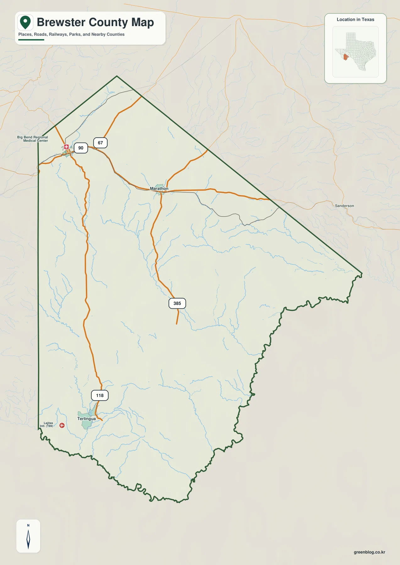
The county map is the best starting point because it places roads, communities, nearby counties, and water features in one frame. U.S. 90 crosses the northern portion through Alpine and Marathon. U.S. 385 turns south at Marathon, while Texas 118 runs south from Alpine toward Terlingua. The map also labels nearby county areas and selected facilities, making it useful for establishing orientation before moving to the more specialized water and elevation views.
Alpine, Marathon and Terlingua define the main travel references
Alpine and Marathon sit on the relatively direct east-west line of U.S. 90, but their connections to southern Brewster County are different. From Alpine, Texas 118 heads south toward Study Butte and Terlingua. From Marathon, U.S. 385 provides the main approach to the northern entrance of Big Bend National Park. The National Park Service lists both of these approaches in its official directions, which is why the two northern communities work so well as orientation points when planning a trip into the county.
These routes also reveal how terrain influences travel. A straight line between two locations may cross mountains, rough desert ground, or land without a public through-road. The highways instead follow usable passes and lower ground for long distances before turning toward their destinations. When you compare the road map with the elevation map later on the page, the reason for some of the bends and long north-south corridors becomes much easier to see.
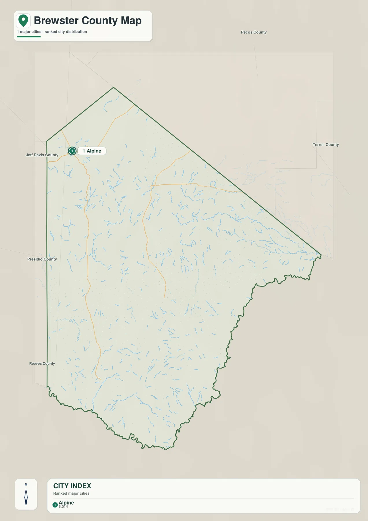
The city map is intentionally simpler than the general county map. In this package, the ranked city dataset highlights Alpine as the one major city. That does not mean Marathon or Terlingua are absent from Brewster County; they remain visible and useful on the broader county map. The simpler city view is valuable when you want to locate the county’s main urban center quickly without the other labels competing for attention.
Desert creeks show how water follows the relief
Brewster County is part of the Chihuahuan Desert, but the water map is far from blank. Alpine Creek and Musquiz Creek appear in the northwestern part of the county. Farther east, Maxon Creek and San Francisco Creek cross a broad section of rougher terrain. Terlingua Creek is one of the more prominent named channels in the southwest, and the map also marks Clanton Lake and Lake Ament nearby. Tornillo Creek, Alamo Creek, Blue Creek, Fresno Creek and other smaller channels form additional drainage lines across the southern half.
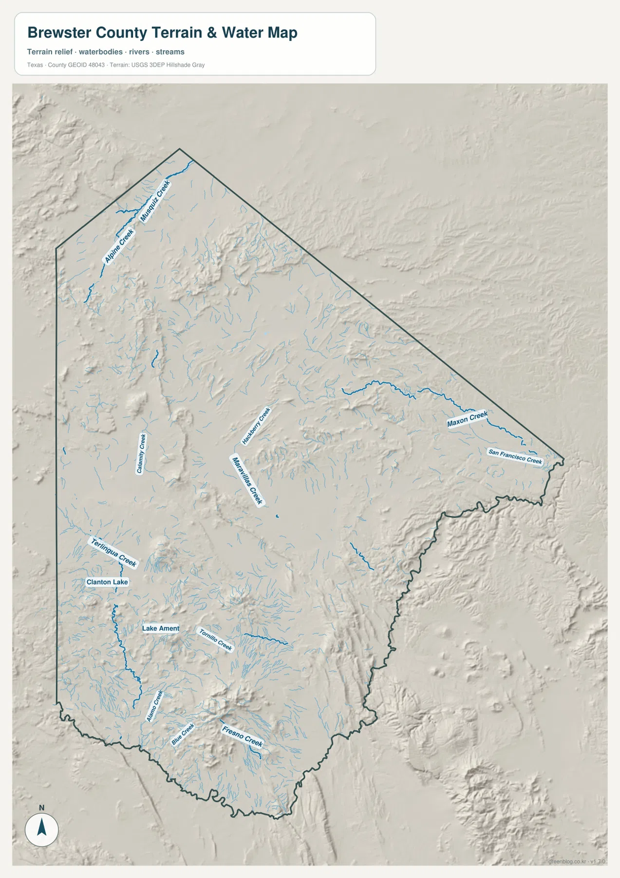
Many of these channels are not large, continuously flowing rivers. In a desert county, however, intermittent creeks and washes still explain the shape of valleys and the direction in which storm runoff travels. The shaded relief behind the blue water lines makes that relationship visible. Channels repeatedly occupy lower ground between ridges, and the southern drainage ultimately points toward the Rio Grande, which traces the county’s border with Mexico.
The Rio Grande is especially important in Big Bend National Park. The National Park Service describes the river as the park’s most prominent water source and notes that it runs through desert scenery and major canyons along the border. The county water map is not a substitute for a detailed park trail or river map, but it provides the larger context: small upland drainages feed toward a much lower border corridor, while mountains and canyon country interrupt simple straight-line movement across the landscape.
The elevation map separates high mountains from the lower border country
The elevation layer shows more clearly than any other map that Brewster County is not a uniform desert plain. In the supplied rendering, the elevation surface spans roughly 437 to 2,326 meters, with a mean of about 1,096 meters. Brown and darker ochre tones mark higher ground in the northwest, across several mountain belts, and around the prominent southern mountain mass. Green tones identify lower areas, especially toward the eastern and southeastern side and along the Rio Grande border.
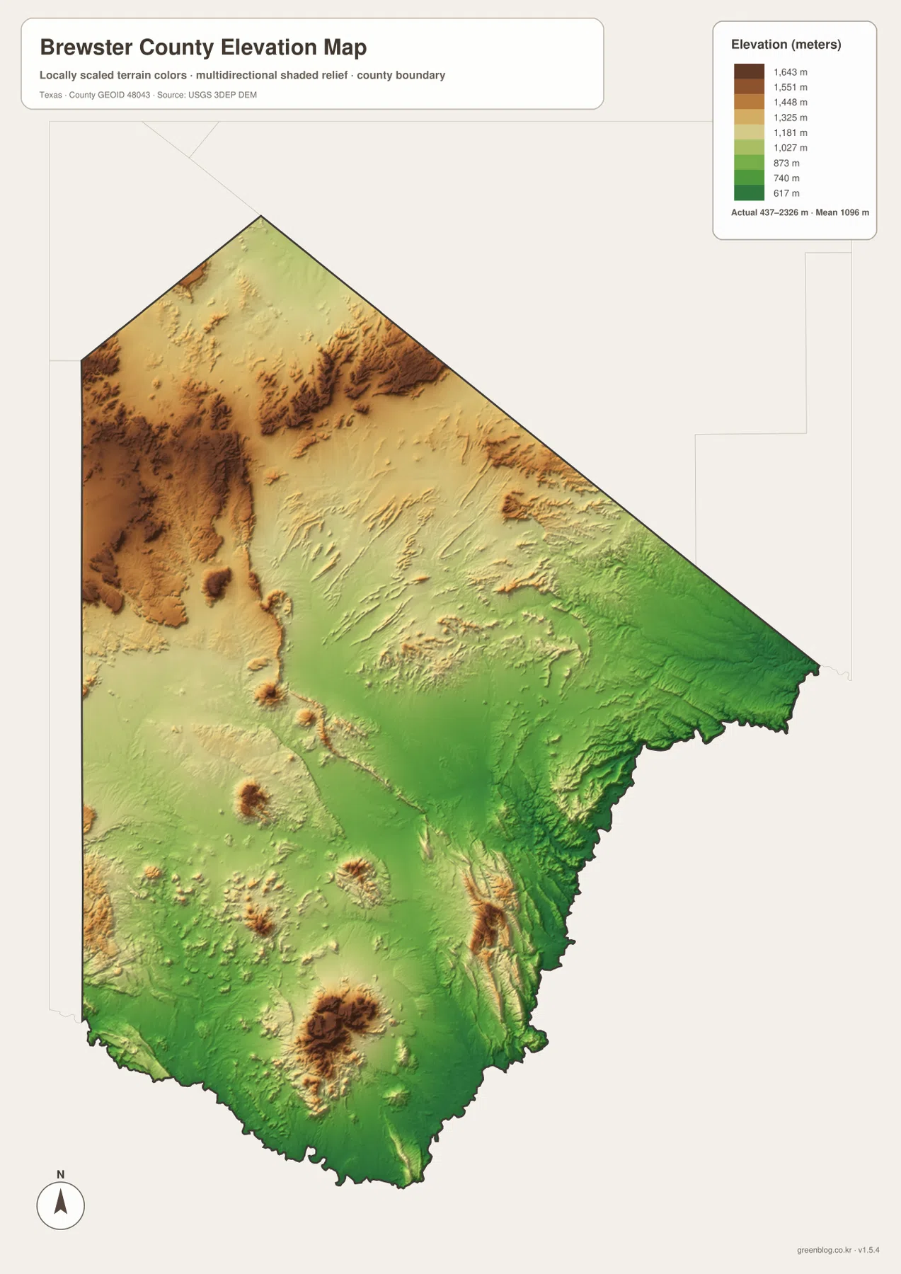
The Chisos Mountains inside Big Bend National Park provide the strongest real-world example of that relief. National Park Service information describes the park as rising from less than 1,800 feet near the Rio Grande to almost 8,000 feet in the Chisos Mountains. The county elevation map uses a generalized raster surface, so its displayed maximum is not a summit list, but the visual contrast is still very clear. A large high-elevation area stands out in the south, while lower green terrain wraps around it toward the international border.
Other high ground is visible farther north and west, including elongated ridges and mountain blocks that break up the county’s interior. This is useful when reading the road network. U.S. 385 and Texas 118 do not simply run down the center of the county on identical terrain; each route crosses a different combination of uplands, basins, and desert valleys. Seeing the highways on the general map and then switching to the elevation layer helps explain why the county has relatively few direct cross-county connections.
Which map is most useful for a particular question?
For basic orientation, start with the county map. It is the easiest view for locating Alpine, Marathon and Terlingua, following U.S. 90, U.S. 385 and Texas 118, and checking which neighboring county lies beyond a boundary. The city map is more focused and works well when you only need to identify Alpine as the principal ranked city in the dataset. It removes much of the extra visual detail and gives the main urban reference more emphasis.
The water map becomes more useful when the question involves valleys, drainage, or the Rio Grande side of the county. Because it combines shaded terrain with named creeks, it helps connect waterways to the shape of the land. The elevation map is the strongest choice for comparing high and low areas, especially the contrast between the mountainous parts of the county and the lower terrain toward the southern and eastern border. Used together, the maps explain Brewster County much better than a single road layer could.
For classroom use, the county and elevation maps make a useful pair because students can compare political boundaries with physical geography. For travel planning, the county map establishes the route while the water and elevation maps help show the terrain surrounding that route. If you need a printable copy rather than the smaller WebP images displayed on the page, use the downloadable JPG archive below.
Three Brewster County details that are easy to miss
First, Alpine and Marathon are not interchangeable gateways even though both sit on U.S. 90. Alpine connects more directly with Texas 118 and the western side of the Big Bend area, while Marathon connects with U.S. 385 and the park’s northern approach. That distinction is easy to overlook on a small statewide road map but obvious on the county map. It also explains why two travelers headed for Big Bend may choose very different southbound routes.
Second, the southern boundary is simultaneously a county edge, a river corridor, and an international border. The irregular line along the bottom of the map follows the Rio Grande rather than a survey-straight boundary. Small creeks descend toward that lower corridor from the interior, and the Big Bend landscape becomes increasingly rugged near major mountain and canyon areas. This is one reason the water and elevation layers add so much information to the basic road view.
Third, the limited number of large city labels is itself meaningful. Brewster County’s enormous area contains long stretches where mountains, desert basins, ranch country, park land, and drainage features are more visually important than a dense chain of towns. The city map highlights Alpine, but the county map and physical maps show why settlement is so widely spaced. Understanding that scale is essential when using the map for travel, teaching, or regional research.
Frequently Asked Questions
Why should I find Alpine and Marathon first on a Brewster County map?
They anchor the main northern road system. U.S. 90 connects Alpine and Marathon, Texas 118 runs south from the Alpine side toward Terlingua, and U.S. 385 runs south from Marathon toward Big Bend National Park. Once those two places are located, the county’s main north-to-south travel pattern becomes much easier to follow.
Why does a desert county need a detailed water map?
Desert waterways still show where valleys and lower ground occur, even when a creek is intermittent. The Brewster County water map labels channels such as Terlingua Creek, Maxon Creek and Tornillo Creek and places them over shaded relief. That combination helps explain drainage direction and the relationship between mountain terrain and the Rio Grande border.
What is included in the downloadable Brewster County map ZIP?
The archive contains four high-resolution A3 JPG files: a county map, city map, terrain-and-water map, and elevation map. The page images are convenient for quick viewing, while the JPG files are better suited to printing or using in larger classroom and reference layouts.
Map File Information
The ZIP archive contains high-resolution A3 JPG versions of the Brewster County county map, city map, water map, and elevation map. Use the files for printing, classroom materials, regional reference, trip planning, or comparing roads with terrain and drainage.
- File Type: JPG
Related Maps
- Pecos County Texas map
- Presidio County Texas map
- Terrell County Texas map
- Reeves County Texas map
- Upton County Texas map
Sources and References
- Handbook of Texas — Brewster County — Background on the county’s location, neighboring counties, transportation routes, and regional history.
- National Park Service — Big Bend National Park Basic Information — Official information on park access, mountain and river elevations, and the Big Bend setting.
- U.S. Census Bureau TIGER/Line Shapefiles — Official geographic boundary and transportation reference data.
- USGS National Hydrography — Federal hydrography information for rivers, streams, and related water features.
- USGS 3D Elevation Program — Federal elevation data used for terrain and relief products.
Green Map creates custom-edited map images using open geographic data sources such as geoBoundaries, Natural Earth, OpenStreetMap, and government open data.
These maps are edited visual materials, not raw data files, and are provided for education, documents, presentations, and graphic reference.