Woodruff County lies in the Arkansas Delta, where rivers, bayous, and broad lowlands matter more than mountains or steep relief. Augusta, the county seat, sits on the east bank of the White River near the western edge of the county. U.S. 64 continues east through Patterson toward McCrory, while Cotton Plant and Hunter occupy more distant southern locations. The Cache River and Bayou DeView cross the interior through a landscape filled with smaller creeks, bays, lakes, and wet bottomlands.
Download the original high-resolution A3 JPG files from this Woodruff County Map set in one ZIP near the end of the page. The package contains the county reference map, ranked city map, terrain-and-water map, and elevation map. The reference view is useful for Augusta, roads, and county boundaries; the water and elevation views show how the White River edge, Cache River corridor, and Bayou DeView fit into a county with only modest changes in height.
Table of Contents
Augusta, Patterson, and McCrory line up across the northern half
Augusta is Woodruff County’s county seat and the clearest place to begin reading the reference map. The county’s official website and the Association of Arkansas Counties both identify Augusta as the seat of government. On the map, the city sits beside the winding western boundary, and the Woodruff County Sheriff’s Office is labeled just east of town. That river-edge setting immediately separates Augusta from the inland communities farther east.
From Augusta, the main eastward route leads through Patterson to McCrory along the U.S. 64 corridor. McCrory is a useful eastern road hub because Routes 17, 269, and 442 branch through or near the area. Routes 37 and 145 appear farther north and northeast. Rather than memorizing every numbered road, following U.S. 64 first provides a simple framework for the northern half of the county.
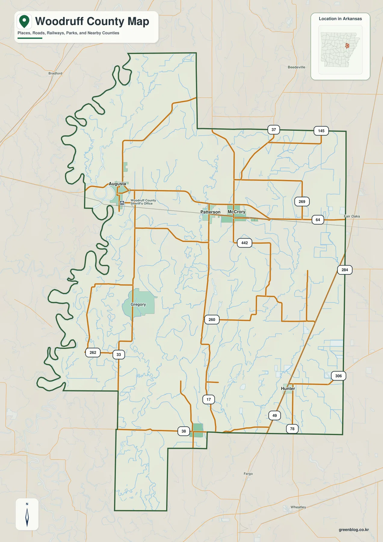
The southern half is more spread out. Gregory appears in the southwestern interior, while Hunter is in the southeast near Routes 49, 78, and 306. Cotton Plant is emphasized on the separate city map farther south. These places are separated by broad rural areas and numerous drainage channels, giving the county a different settlement pattern from the tighter U.S. 64 corridor in the north.
The western county line is especially distinctive. The Encyclopedia of Arkansas states that the White River forms most of Woodruff County’s western boundary. On the reference map, that edge bends repeatedly north and south of Augusta instead of following a straight survey line. Much of the eastern boundary, by contrast, consists of long straight sections.
The city map shows Augusta and McCrory as two closely matched centers
The ranked city graphic contains Woodruff County’s five incorporated cities. Augusta is listed first and McCrory second, with nearly identical values in the supplied image. Cotton Plant ranks third, Patterson fourth, and Hunter fifth. Removing most of the road detail makes it easy to see how the two larger northern communities compare with the much smaller places farther south.
Augusta and McCrory are both in the northern half, but their settings are different. Augusta is on the White River, while McCrory is well inland to the east. Patterson lies between them close to the U.S. 64 corridor. Cotton Plant is much farther south and slightly west of center, and Hunter is near the southeastern side. The large gaps between the southern towns are as noticeable as the ranking itself.
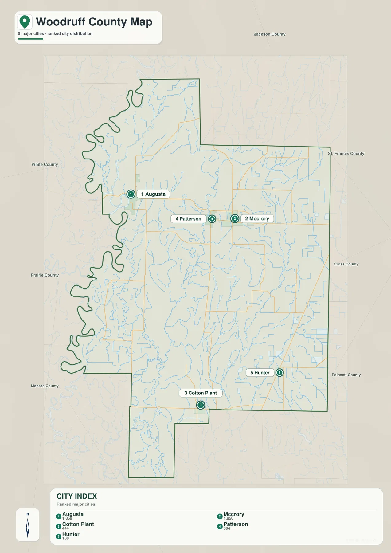
The population figures printed on the supplied graphic should be treated as comparison values in the image rather than current Census estimates. The official Woodruff County site also lists Augusta, Cotton Plant, Hunter, McCrory, and Patterson as the five incorporated cities. For this page, the graphic is most useful as a quick guide to where those principal communities sit within the county.
The White and Cache rivers define much of the western lowland
The terrain-and-water map makes Woodruff County’s river geography much clearer than the road map alone. The Encyclopedia of Arkansas describes the county as a level, fertile plain watered and drained by the White and Cache rivers. The White River follows most of the western boundary, while the Cache River cuts southward through the western interior. Around those rivers, the map contains numerous bends, bays, old channels, and small lakes.
North of Augusta, Teague Lake and Taylor Bay are labeled close to the western side. Farther south, Horseshoe Lake and Straight Lake sit near the river lowlands, followed by Seven Mile Lake and Cache Bay. These names help show that the western half is not simply one river channel running beside farmland. It is a complex low area with many separate water bodies and curving channels.
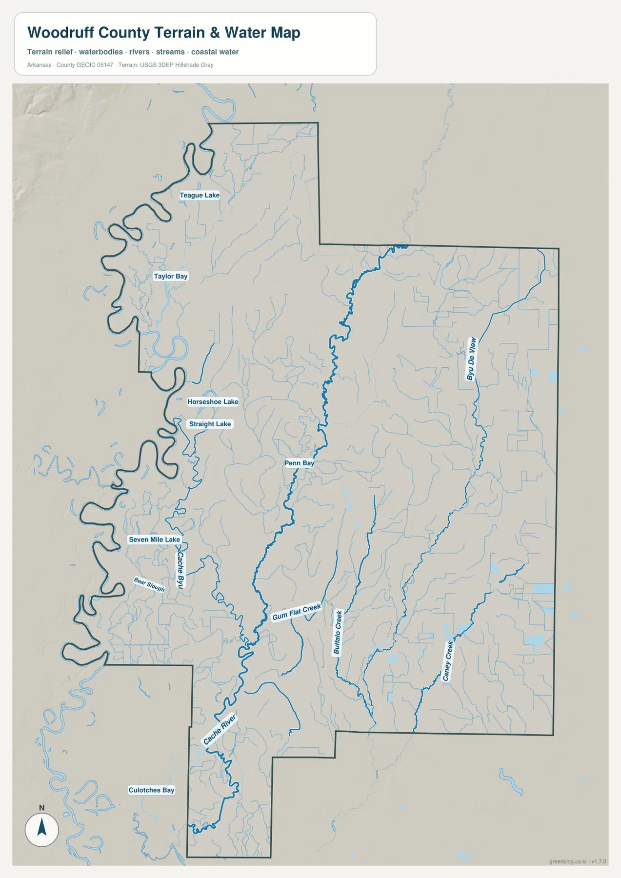
Penn Bay appears east of the Cache River, while Gum Flat Creek joins the network farther south. Buffalo Creek and Caney Creek run through the central and eastern interior. Bayou DeView is the strong eastern water reference, extending north to south through the right side of the map. Together, these channels divide the flat county into several long drainage corridors even though the overall terrain is not mountainous.
The U.S. Fish and Wildlife Service describes Cache River National Wildlife Refuge as a landscape along the Cache River, White River, and Bayou DeView that contains meandering channels, shallow sloughs, oxbow lakes, and bottomland hardwood forest. Woodruff County is part of that larger refuge landscape. That context helps explain why the water map contains so many irregular channels and wetland features, especially in the western and southern lowlands.
This is a county-scale geographic water reference, not a flood-hazard, parcel, navigation, or water-quality map. Use it to locate rivers, creeks, bays, and lakes and to understand their relationship with towns and roads. Current safety, legal, or property decisions require specialized data from the responsible agencies.
The county is very flat, with only small differences in elevation
The supplied elevation map has an actual range of only about 50 to 72 meters, with a mean near 61 meters. That narrow range is important. Woodruff County is not a place where brown colors indicate mountains. The map is locally scaled so relatively small differences become visible, which makes the slightly higher east and northeast look much stronger than they would on a statewide elevation map.
Lower green terrain is broad along parts of the White River and Cache River lowlands and through much of the southern section. The eastern side contains more tan and brown areas that are higher relative to the rest of the county, but the change remains modest in absolute terms. This pattern fits the Encyclopedia of Arkansas description of Woodruff County as a generally level plain.
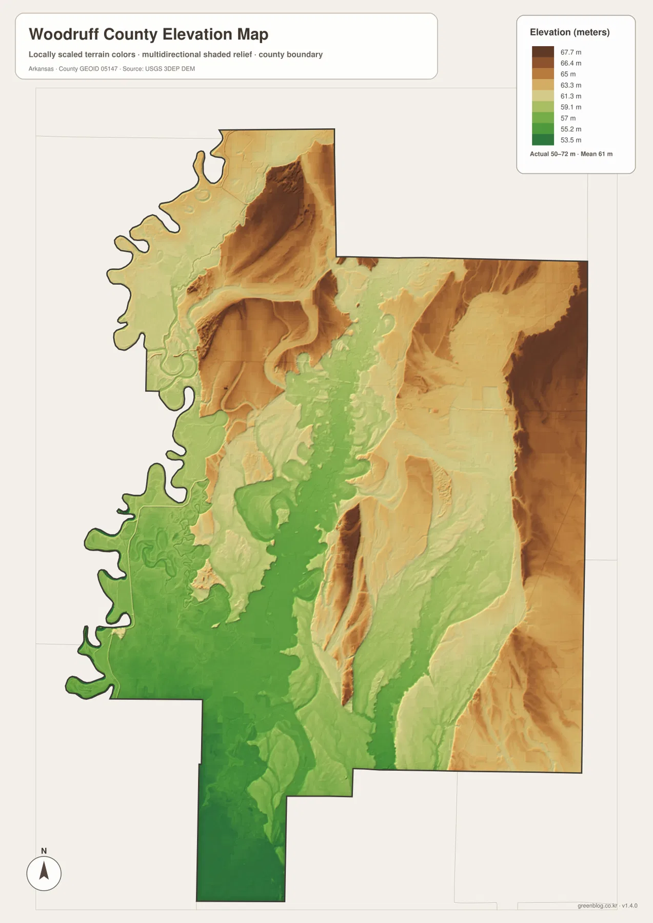
Comparing the water and elevation maps makes the low western and southern corridors especially easy to recognize. Curving channels and lakes cluster around parts of the White and Cache river system, while the central and eastern creeks cross slightly higher surfaces before reaching lower drainage areas. The map is useful precisely because it reveals these subtle differences in a county that can otherwise look uniformly flat.
The elevation colors are not survey-grade property measurements. They are appropriate for broad county comparison, but not for flood decisions, levee design, agricultural drainage engineering, parcel elevation, or construction. Detailed USGS 3D Elevation Program data or professional surveys are better choices when exact height is required.
Augusta and U.S. 64 provide a simple way to orient the county
A first-time reader can begin at Augusta on the White River and then follow U.S. 64 east through Patterson toward McCrory. Those three places establish the northern part of the map. From there, Cotton Plant provides a southern reference closer to the middle of the county, while Hunter marks the southeastern side. This sequence is easier than trying to follow every small rural road at once.
Next, switch to the water view and find the Cache River. It runs south through the western interior, leaving the White River on the county edge and Bayou DeView farther to the east. Buffalo Creek and smaller channels occupy the broad space between them. Once these waterways are located, the positions of McCrory, Cotton Plant, and Hunter become easier to connect with the county’s natural landscape.
Neighboring county labels provide additional orientation. Jackson County lies to the north, St. Francis and Cross counties are to the east, Poinsett County is toward the southeast, and Monroe and Prairie counties are on the southern and western side. White County lies to the northwest. Near any boundary, follow the dark Woodruff County outline rather than assuming that a nearby road or place label falls inside the county.
Use the file that best matches the question you are answering
The county reference map is the best starting point for Augusta, Patterson, McCrory, roads, surrounding counties, and the boundary. The ranked city map is cleaner when the five incorporated cities are the main subject. The terrain-and-water map is the strongest choice for the White and Cache rivers, Bayou DeView, lakes, bays, and creeks. The elevation map is useful when you need to show that the county is flat but not perfectly level.
Combining two maps can make a local explanation clearer. Pair the county and water views for Augusta to show how the city sits beside the White River boundary. Use the water and elevation maps for Cotton Plant and the southern county to show the broad lowland around the Cache River. Around McCrory and Hunter, the reference and elevation maps help connect roads and towns with the slightly higher eastern terrain.
Each downloadable JPG measures 2572 × 3638 pixels, a high-resolution portrait format suitable for A3 printing, label enlargement, reports, and classroom handouts. Keep the original aspect ratio when resizing so roads, rivers, and the county outline are not distorted. Printer margins and scaling settings vary, so checking one test page before a larger print run is recommended.
Frequently Asked Questions
What is the county seat of Woodruff County, Arkansas?
Augusta is the county seat. It sits on the east bank of the White River and serves as the western starting point for the U.S. 64 corridor toward Patterson and McCrory. Both the official county site and the Association of Arkansas Counties identify Augusta as the seat of government.
Where are the Cache River and Bayou DeView?
The Cache River runs through the western interior of Woodruff County, roughly parallel to the White River boundary in several areas. Bayou DeView is much farther east. Buffalo Creek and numerous smaller streams occupy the broad lowlands between these major water corridors.
Do the brown areas on the elevation map represent mountains?
No. The supplied elevation range is only about 50 to 72 meters. Brown indicates ground that is slightly higher relative to the rest of Woodruff County, not mountainous terrain. The county as a whole is part of the low, generally level Arkansas Delta.
Map File Information
The ZIP contains the original Woodruff County reference, city, terrain-and-water, and elevation maps as high-resolution JPG files.
- Included Files: County reference map, city map, terrain-and-water map, elevation map
- Printable Size: 2572 × 3638 pixels each
- File Type: Four high-resolution JPG files in one ZIP archive
Related Maps
Sources and References
- Woodruff County, Arkansas – Official About Page – County-seat, incorporated-city, Arkansas Delta, and local background information.
- Encyclopedia of Arkansas – Woodruff County – County-specific geography and history, including the White River, Cache River, and Bayou DeView.
- U.S. Fish & Wildlife Service – Cache River National Wildlife Refuge – Official information about the wetland, river, slough, oxbow-lake, and bottomland forest landscape.
- USGS National Hydrography – Official U.S. river, stream, lake, and hydrographic data information.
- USGS 3D Elevation Program – Official elevation and terrain data information.
Green Map creates custom-edited map images using open geographic data sources such as geoBoundaries, Natural Earth, OpenStreetMap, and government open data.
These maps are edited visual materials, not raw data files, and are provided for education, documents, presentations, and graphic reference.