Schley County is a small west-central Georgia county whose geography becomes easier to understand once Ellaville, the road network, the creek valleys, and the rolling uplands are viewed together. The county map places Ellaville near the center of the southern half, while the water and elevation maps show that the surrounding countryside is cut by many small streams rather than dominated by one large river. The downloadable ZIP on this page contains four high-resolution JPG maps covering the county boundary and roads, the ranked city pattern, waterways and terrain, and elevation.
Ellaville is the county seat and the only ranked major city on the supplied city map. That makes Schley County different from a county where several towns compete for attention. Here, the most useful questions are often how roads spread outward from Ellaville, how rural place labels such as Concord, Walls Crossing, and Bumphead sit around that center, and how Buck Creek and the Muckalee Creek system fit into the low valleys visible on the terrain map. Neighbor labels also place Schley County among Marion, Sumter, Taylor, and Macon counties.
Table of Contents
Ellaville anchors a road network that fans across the county
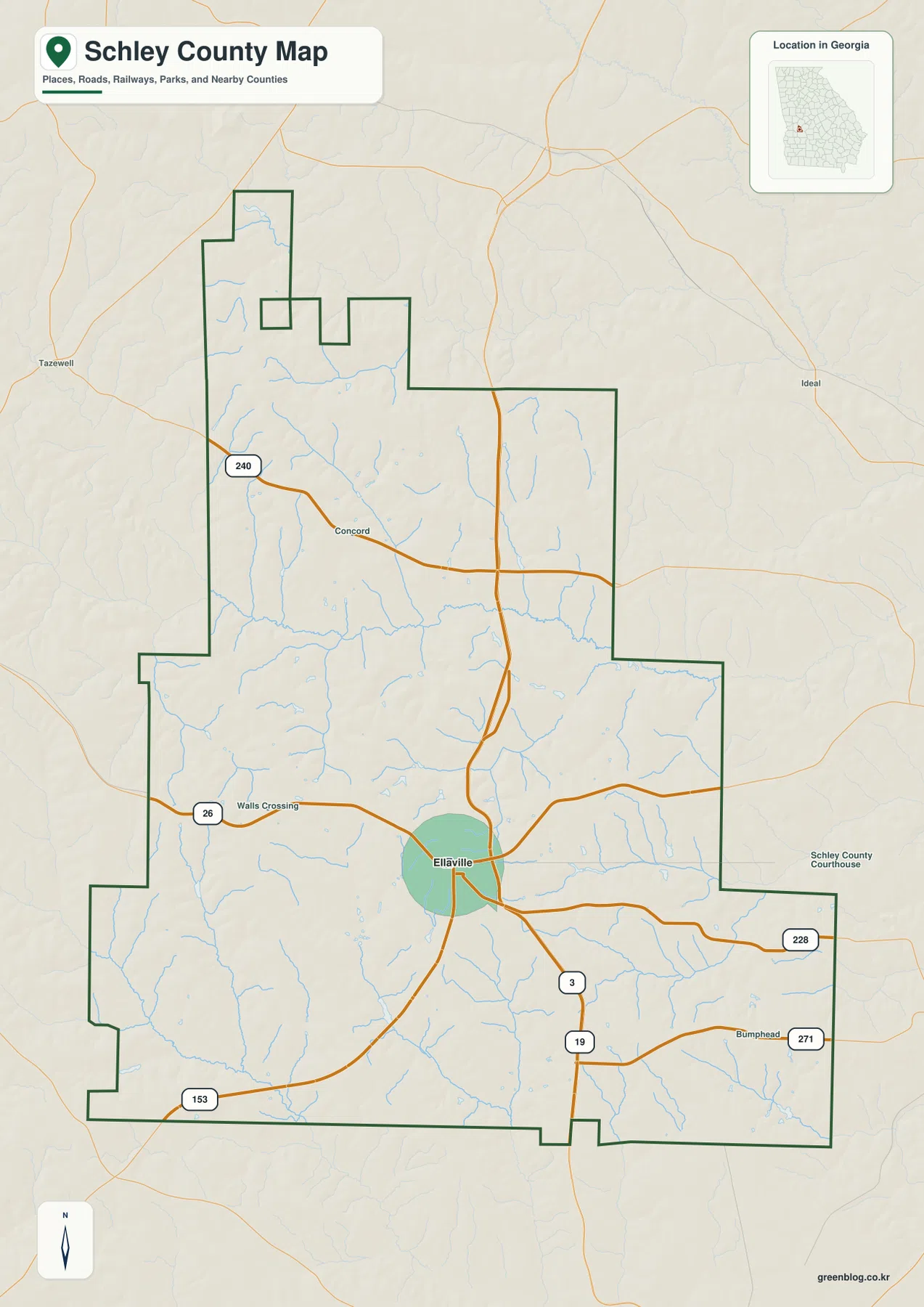
The general county map makes Ellaville the clearest orientation point. Route 26 crosses the county through the Ellaville area and continues west, while Routes 3 and 19 run south from the central road junction. Route 228 extends toward the eastern side, Route 240 appears in the northwest, Route 153 reaches the southwest, and Route 271 is labeled near the southeastern edge. The pattern is useful because it shows a compact county seat connected to several rural approaches rather than a dense street grid spread across the entire county.
The county boundary itself is irregular. A narrow, stepped northern section gives way to a broader middle and southern body, so the county cannot be understood as a simple rectangle around Ellaville. Concord is labeled northwest of the county seat, Walls Crossing lies to the west, and Bumphead appears toward the southeast. Those smaller labels help explain how the regional roads pass through the countryside before reaching neighboring counties. This map is intended for geographic reference; it is not a parcel map, a legal survey, or a substitute for detailed local street data.
The city map is unusually simple: Ellaville stands alone
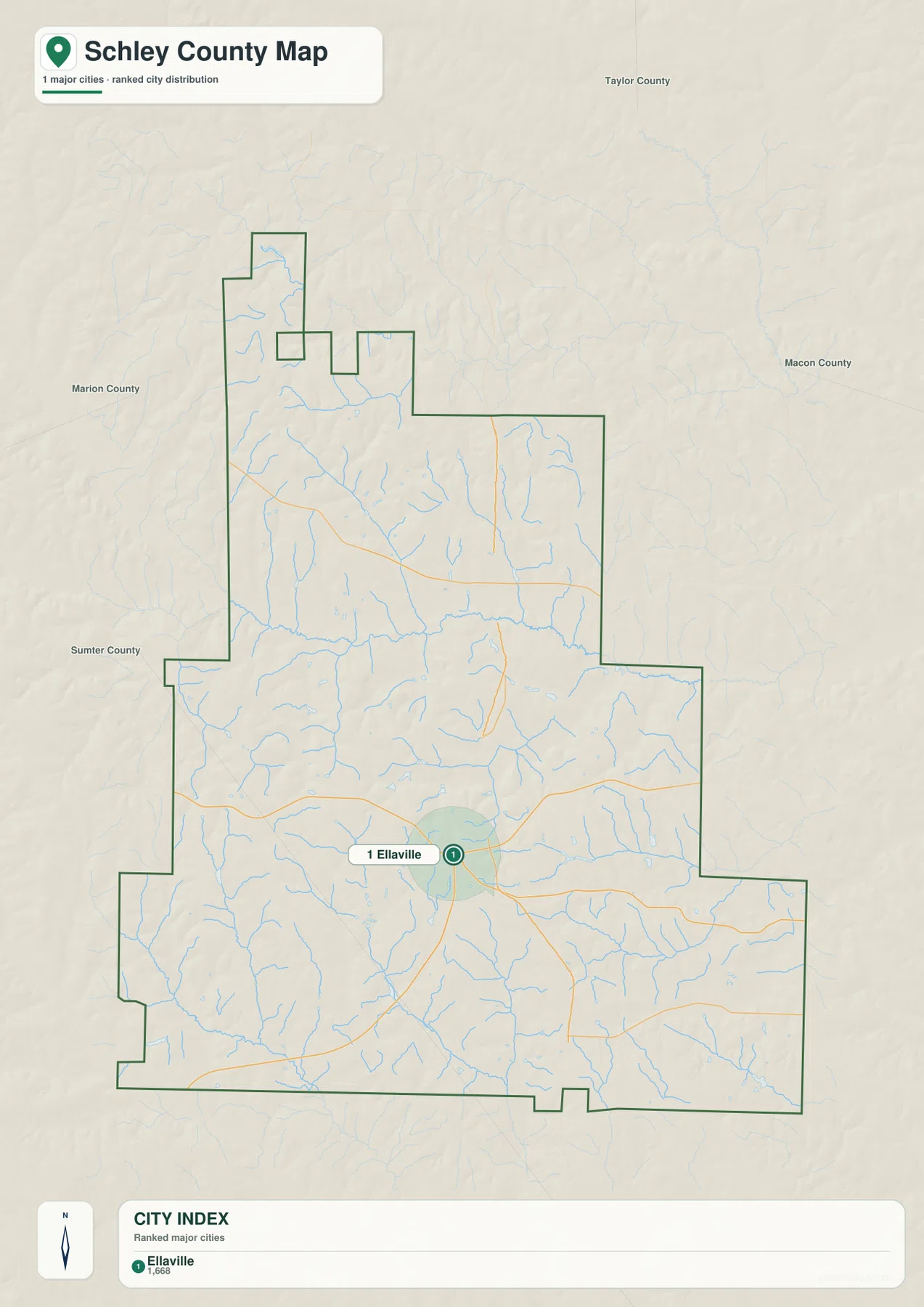
The city-distribution map identifies one ranked major city: Ellaville. Its city index shows a population figure of 1,668 on the supplied map. That number should be treated as the map’s displayed reference value rather than a promise of the latest population estimate, because official population figures can change with new Census releases. The important geographic point is that no second ranked city marker appears elsewhere inside the county boundary.
Ellaville sits close to the middle of the county’s southern half where several roads meet, while large areas to the north and along the outer eastern and western sections remain rural on this city view. For a presentation that only needs the primary urban center, this map is less cluttered than the full county map. If the task requires road numbers, small communities, or a clearer sense of how Ellaville relates to the county’s irregular outline, the general county map is the better companion.
Buck Creek and the Muckalee system divide the rural landscape into many small valleys
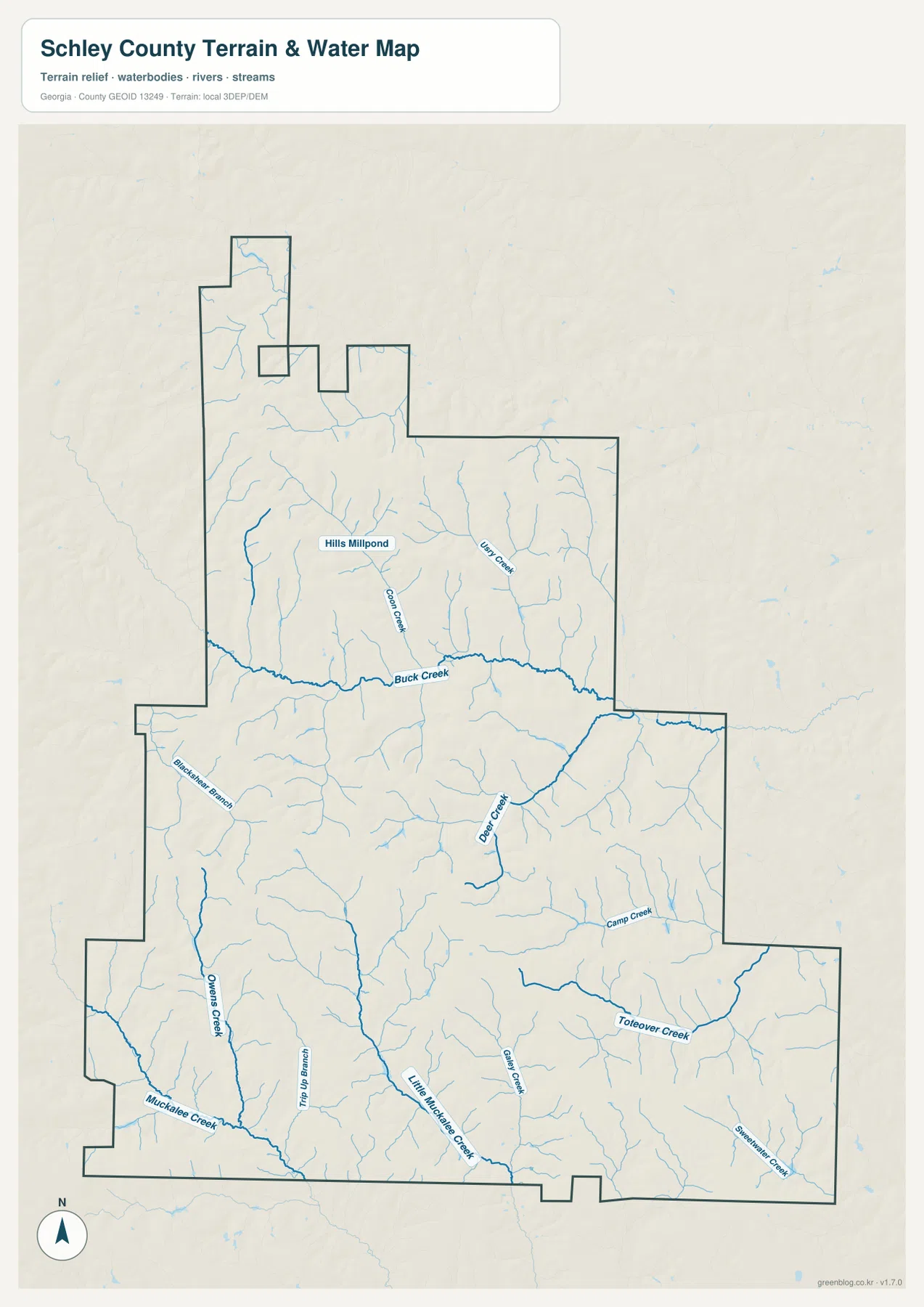
The water map adds a level of detail that the road map intentionally leaves out. Buck Creek forms one of the most prominent named channels across the northern-middle portion of the county. Farther south, Muckalee Creek and Little Muckalee Creek occupy the lower part of the map, while Blackstone Branch and Owens Creek appear on the western side. Camp Creek is labeled toward the east, and Hills Millpond is marked in the northern section. Numerous unnamed tributaries fill the spaces between those larger labels.
This network matters because Schley County does not have one broad river corridor that organizes the entire map. Instead, many narrow drainage lines descend from short ridges and join larger creeks. Around Ellaville and Route 26, small tributaries approach from several directions. The Buck Creek valley creates a particularly visible low corridor across the county, and the Muckalee waterways define lower ground toward the south and southwest. The map is useful for locating named streams and understanding terrain, but it should not be treated as a flood-zone map, navigation chart, or statement about water access rights.
Elevation stays moderate, but the creek valleys cut clearly into the uplands
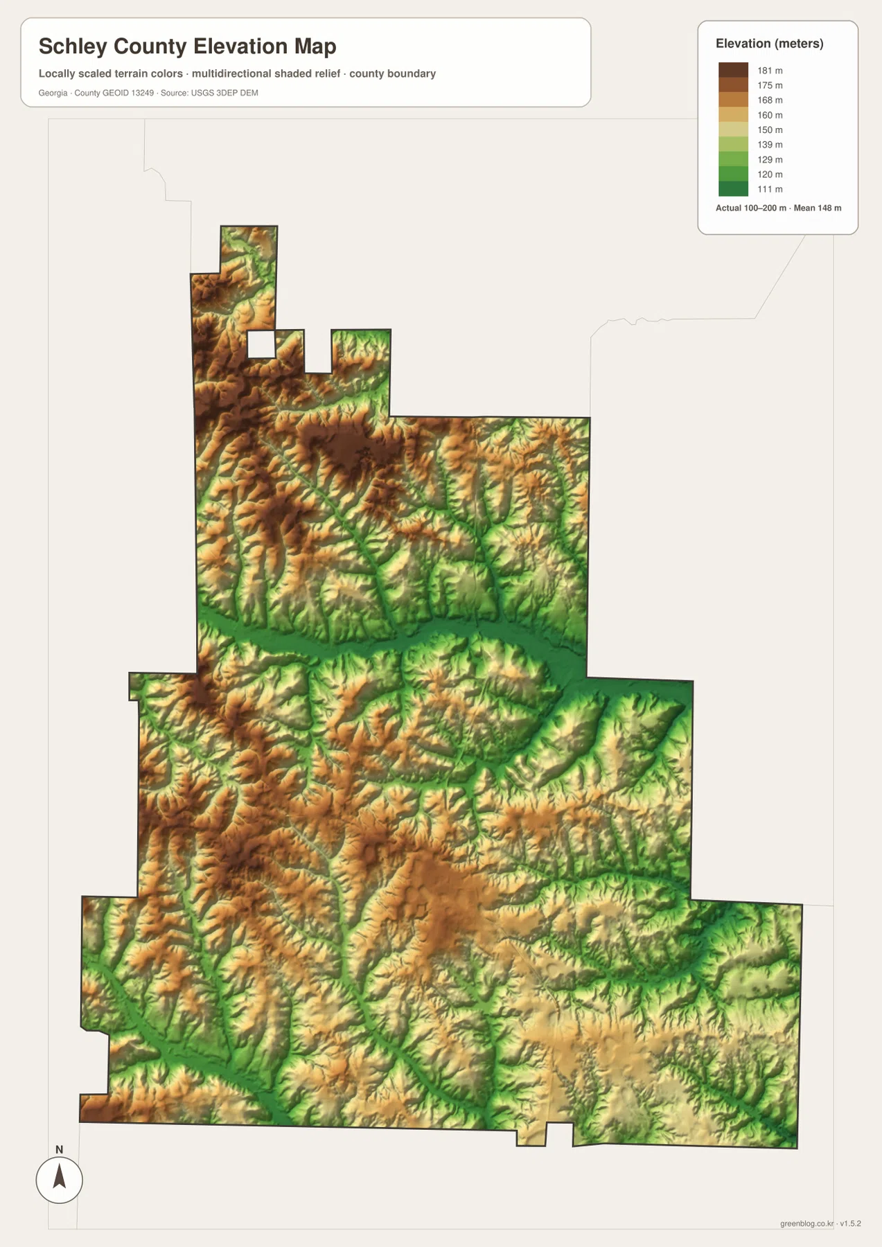
The supplied elevation map reports an actual range of about 100 to 200 meters and a mean elevation of 148 meters. Schley County is therefore not mountainous, yet the shaded surface is far from flat. Brown and tan uplands stand out across parts of the northwest, north, and west, while green bands trace lower stream valleys. One of the strongest contrasts follows the Buck Creek corridor across the middle of the county, where the lower valley separates higher ground to the north from rolling terrain to the south.
South of Ellaville, the relief remains gentle but broken. Short ridges are divided by narrow valleys that feed Muckalee Creek, Little Muckalee Creek, and smaller tributaries. The western side also contains several higher ridges separated by green drainage lines. When this elevation view is compared with the water map, many of those green corridors line up with named streams. The elevation surface is a regional visualization rather than survey-grade measurement, so engineering, construction, or property work should use appropriate authoritative elevation products.
Roads, creeks, and relief explain more when they are compared side by side
The map set becomes most useful when one question leads naturally to the next. Ellaville and the numbered roads provide the starting frame, then the creek layer explains why the countryside is crossed by so many narrow valleys. Elevation adds the final piece by showing which of those corridors sit below the surrounding ridges, while the simplified city view confirms that the settlement pattern is centered overwhelmingly on Ellaville rather than divided among several towns.
For example, Route 26 looks like a straightforward east-west road on the general map, but the water and terrain views reveal that it crosses a landscape broken by tributaries. North of Ellaville, the Buck Creek valley forms a long low band through the county. South and southwest of town, Muckalee Creek and Little Muckalee Creek occupy other low corridors between rolling ridges. Seeing these pieces together makes the county’s rural geography more specific than a description that simply calls it agricultural or lightly developed.
Choose the map that matches the question you need to answer
For basic orientation, the general county map keeps the outline, Ellaville, numbered routes, and smaller place labels on one page. A cleaner presentation focused on settlement can use the city version, where Ellaville is the single ranked marker. Questions about Buck Creek, the Muckalee waterways, or the many tributaries are better answered with the water view, while terrain-focused work benefits from the elevation surface because it separates upland ridges from lower creek valleys.
The downloadable JPG files are larger than the web previews and are better suited to printing, classroom handouts, reports, or presentations where labels need to remain legible. Each file measures 2572×3638 pixels. The four maps are not duplicates: they use the same county boundary as a common frame while emphasizing different information, so one file may be enough for a simple location task and two or more may work better for a detailed county explanation.
Frequently Asked Questions
Why does the city map show Ellaville as the only ranked major city?
The supplied ranked city map contains one major city marker, Ellaville. Smaller rural places can still be seen on the general county map, but they are not presented as additional ranked cities on the city-distribution version.
Which waterways are easiest to identify on the water map?
Buck Creek is one of the most prominent named channels across the northern-middle part of the county. Muckalee Creek and Little Muckalee Creek are clearly labeled farther south, while Blackstone Branch, Owens Creek, Camp Creek, Hills Millpond, and many smaller tributaries add local detail.
What is included in the Schley County map ZIP?
The archive contains four high-resolution JPG files: a county boundary and road map, a ranked city map, a water and terrain map, and an elevation map. Each image is 2572×3638 pixels, separate from the smaller WEBP previews used on the page.
Sources and reference links
The article is based on the supplied Schley County map set. The links below provide authoritative or county-specific references for population, local history, boundaries, hydrography, and elevation data where a reader needs to verify or update details.
- U.S. Census Bureau QuickFacts for Schley County
- New Georgia Encyclopedia: Schley County
- New Georgia Encyclopedia: Ellaville
- U.S. Census Bureau TIGER/Line boundary data
- USGS National Hydrography
- USGS 3D Elevation Program
Map File Information
The ZIP contains the Schley County reference map, ranked city map, water and terrain map, and elevation map as four original high-resolution JPG files.
- Included Files: 4 high-resolution JPG maps
- Printable Size: 2572×3638 px each
Related Maps
Green Map creates custom-edited map images using open geographic data sources such as geoBoundaries, Natural Earth, OpenStreetMap, and government open data. These maps are edited visual materials, not raw data files, and are provided for education, documents, presentations, and graphic reference.