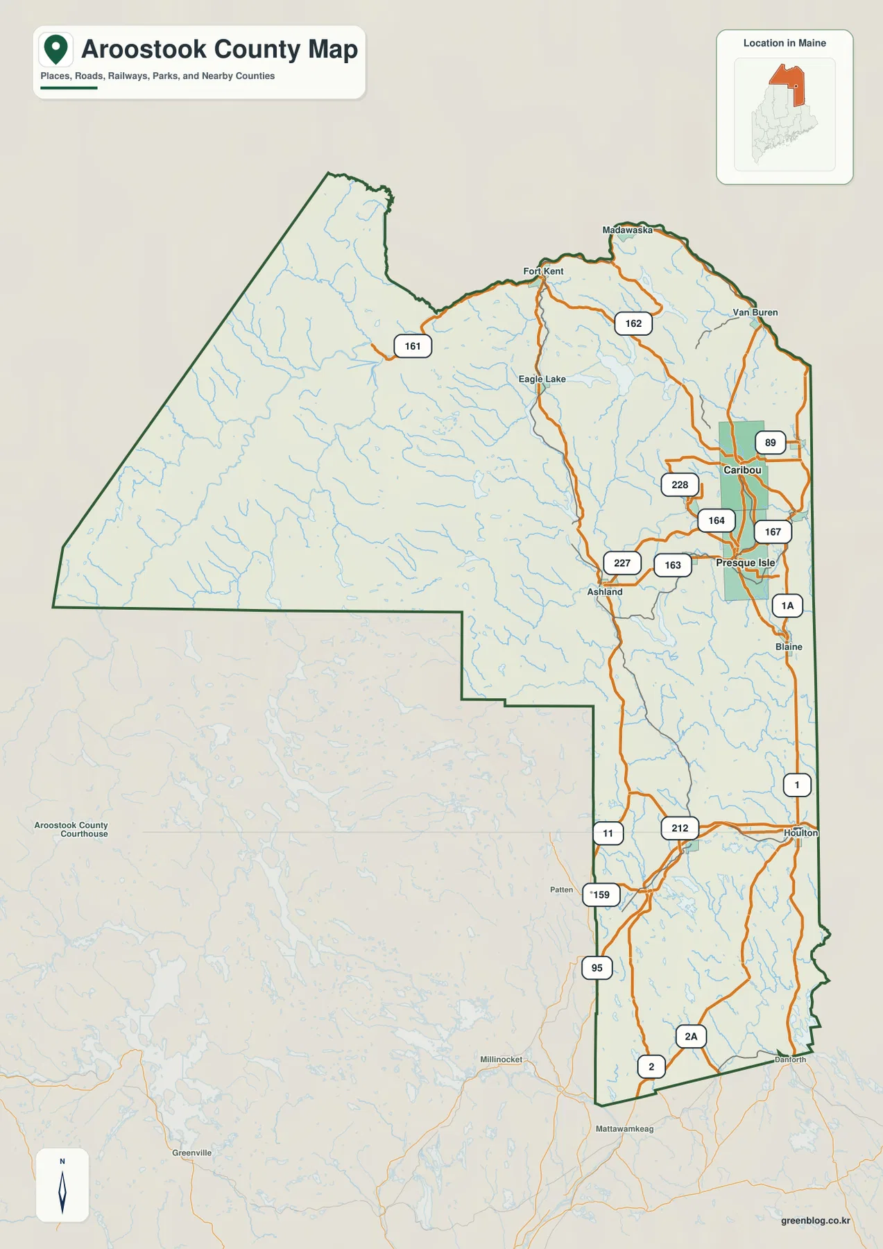
Aroostook County fills the northern end of Maine with a long, irregular outline that stretches from Houlton in the south to Fort Kent, Madawaska, and Van Buren along the northern border. Its eastern side contains many of the county’s best-known communities and road corridors, while the broad western interior is dominated by forests, lakes, and branching rivers. The maps on this page make those contrasts easier to follow, and the original high-resolution JPG files can be downloaded together in one ZIP archive. High-resolution map files are available for download in the section below.
A useful way to orient yourself is to find four reference areas first: Houlton near the southern end, Presque Isle and Caribou in the east-central part of the county, and the St. John Valley communities at the top. The Aroostook County Charter identifies Houlton as the county seat, while the city-index map emphasizes Presque Isle and Caribou as the two ranked cities in this map set. Those different reference points show why the county is better understood as a chain of distinct northern Maine regions than as a place organized around one single center.
Table of Contents
Following the road network from Houlton to the St. John Valley
Houlton is the easiest southern starting point on the county map. U.S. 1 heads north from the Houlton area toward Blaine, Presque Isle, and Caribou, while U.S. 2 crosses the southern part of the county and 2A follows another route near the southeastern edge. Several roads meet around Houlton, so the town stands out as a practical transportation reference even before its role as the county seat is considered. From here, the shape of Aroostook County becomes easier to understand because the map narrows and then extends far to the north.
The road pattern becomes much denser around Presque Isle and Caribou. In addition to U.S. 1 and 1A, the map shows Routes 163, 164, 167, 227, 228, and 89 serving different parts of the east-central area. Presque Isle and Caribou sit close enough together that their surrounding road networks visually overlap, creating one of the busiest-looking parts of the county map. Roads extending west toward Ashland help connect this populated eastern corridor with the much less developed interior.
Farther north, the network changes character as it approaches the St. John Valley. Fort Kent and Madawaska sit near the northern edge, and Van Buren is farther east along the border. Route 161 reaches toward Fort Kent through the interior, Route 162 appears around Madawaska, and U.S. 1 continues through the northeastern side of the county. Rather than spreading in every direction as the roads do around Houlton or Presque Isle, several northern routes follow the long border and river-valley geography.
The western half of Aroostook County looks very different. Large communities are sparse, streams are numerous, and the road network is comparatively thin. Eagle Lake and Ashland provide useful reference points between the settled east and the interior, while Routes 11, 159, 212, and the road marked 95 help define some of the southern and western connections near Patten. The contrast is important: the county is not simply a long strip of towns, but a large northern landscape where settlement is concentrated in selected corridors.
The boundary itself adds context. Aroostook County reaches the Canadian border on its northern and eastern sides and meets Washington, Penobscot, Piscataquis, and Somerset counties to the south and southwest. The inset places the county at the very top of Maine, which is useful when the detailed outline feels difficult to recognize at first glance. This is a general geographic reference map, not a live navigation product, so current road closures, border procedures, and construction should always be checked with the appropriate agencies before travel.
Why Presque Isle and Caribou stand out on the city map
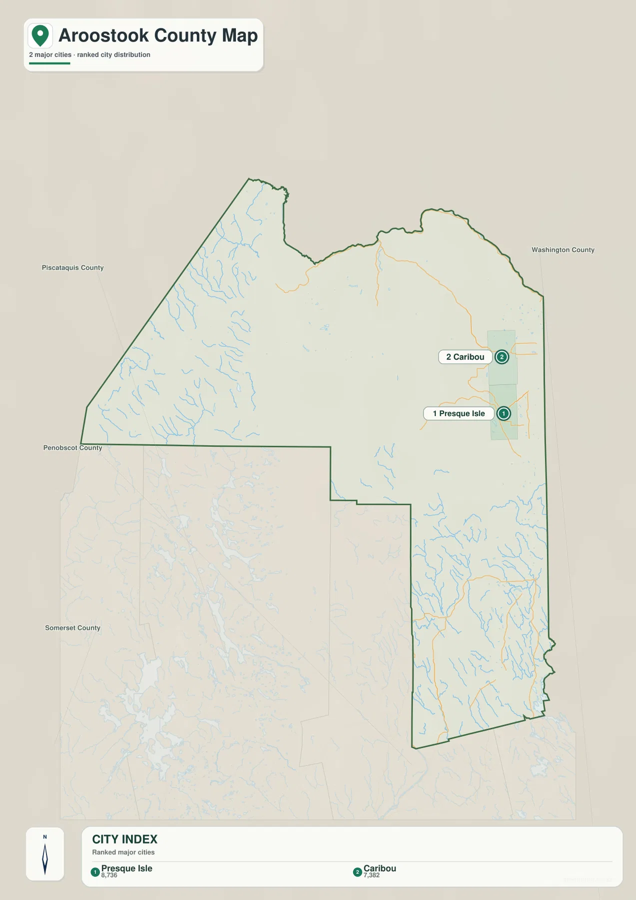
The city-distribution map removes most of the road detail and makes one pattern especially clear: the two ranked cities are clustered in the east-central part of Aroostook County. Presque Isle and Caribou appear close to one another even though the county extends a long distance north, south, and west of them. That visual concentration is useful because it explains why the main county map looks busiest around the same area.
The CITY INDEX printed on the map lists Presque Isle first with 8,736 and Caribou second with 7,382. Those numbers should be treated as values used in the map’s city index rather than as a claim about the latest population, because the map does not state a reference year for the figures. The more important information for this page is geographic: both cities occupy the same general east-central corridor and sit near several of the county’s major roads.
Houlton does not appear in this two-city ranking, but that does not make it less important to the county. Houlton is legally the county seat and is organized as a town rather than a city. The map is therefore doing something narrower than ranking every settlement in Aroostook County. It highlights the locations of the two major cities included in its index, while the full county map provides the broader picture of towns, roads, and border communities.
Neighboring county labels also help explain the geometry. Piscataquis and Somerset counties lie to the west and southwest, Penobscot County appears along the south, and Washington County touches the southeast. The Aroostook outline widens dramatically to the west and then narrows in the lower east, so Presque Isle and Caribou are not located near the geographic center of the entire shape. Seeing that broad western interior on the same map keeps the two-city cluster in perspective.
This simplified map is especially useful when a presentation or school project needs to answer a focused question such as, “Where are the county’s principal cities concentrated?” It is less useful for finding Fort Kent, Madawaska, Van Buren, Houlton, or the detailed routes between communities. For those questions, return to the first map. Used together, the two maps separate urban concentration from the much larger pattern of roads and settlements across northern Maine.
Rivers and lakes across the St. John, Aroostook, and Mattawamkeag watersheds
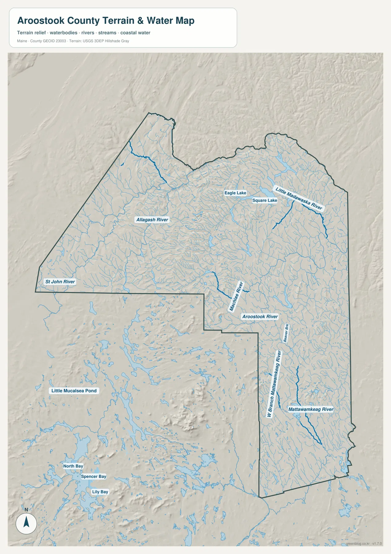
The terrain-and-water map shows just how much of Aroostook County is organized by rivers rather than roads. The St. John River system is a defining feature of the northern and northwestern landscape, collecting water from a wide forested area before continuing through the border region. The Allagash River is one of the most prominent tributary corridors in the northwest, and numerous smaller streams branch toward it. On this map, the western side that seemed almost empty of towns on the road map becomes dense with waterways.
Eagle Lake and Square Lake provide clear landmarks in the northern interior. Eagle Lake is also labeled on the general county map, so it can be used to compare road access with the surrounding water network. Square Lake lies farther east, with small streams and lake chains scattered through the same broad region. These features help explain why northern Aroostook is not just a border corridor: inland lakes and river valleys shape the geography between Fort Kent, Madawaska, Ashland, and the central part of the county.
In central and eastern Aroostook, the Aroostook River and Little Madawaska River become important reference lines. The Aroostook River crosses the part of the county associated with Presque Isle and Caribou, while the Machias River is shown farther inland. Comparing this map with the road map reveals how the more settled eastern corridor is still threaded by a very dense drainage network. Roads and towns may dominate the first map, but the hydrology map shows that rivers remain fundamental geographic features in the same area.
The southern part of the county belongs to a different large drainage pattern. The Mattawamkeag River and West Branch Mattawamkeag River run through the lower portion of the map, separate from the northern St. John system. This matters because Aroostook County is too large to be described as one simple watershed. The northwest, east-central, and southern sections connect to different major river systems, which is one reason the terrain-and-water map adds so much information beyond the road network.
Relief shading adds another layer without turning the map into an elevation survey. The western and southwestern interior shows more pronounced ridges and rolling terrain, while much of the settled eastern side appears gentler at this scale. The shading is best used to understand broad differences in landform, not to estimate an exact height or slope at a particular point. Surveying, engineering, trail safety, and construction decisions require current official elevation data rather than a generalized shaded-relief background.
The same caution applies to the water features. This map identifies rivers, streams, lakes, and terrain for general reference; it does not show flood probability, real-time water level, water quality, depth, or navigability. Anyone making a safety, property, or boating decision should consult current USGS, FEMA, state, or local information. Used within its intended purpose, however, the map is an effective way to compare the St. John, Allagash, Aroostook, Little Madawaska, and Mattawamkeag systems across one very large county.
Choosing the clearest map for a county this large
For general orientation, start with the county map because it combines boundaries, settlements, and major roads. Houlton gives you a southern anchor, Presque Isle and Caribou identify the busy east-central corridor, and Fort Kent, Madawaska, and Van Buren show how far the county reaches into the St. John Valley. Once those places are familiar, the thinner road network around Ashland, Eagle Lake, and the western interior becomes much easier to interpret.
Use the city map when the goal is to show concentration rather than detail. It makes the relationship between Presque Isle and Caribou immediately obvious and reduces the distraction of dozens of route numbers. That simplicity is valuable in a slide, handout, or classroom explanation, but it should not be mistaken for a complete settlement map. Houlton and the northern border communities still matter to the county even though they are outside this two-city index.
The terrain-and-water map is the best choice for explaining why the western half feels so different from the settled east. Allagash River tributaries fill the northwest, the St. John system dominates the far north, the Aroostook and Little Madawaska rivers cross the east-central region, and the Mattawamkeag system appears in the south. Looking at those features after the road map makes the county’s internal contrasts much more concrete than a written description alone.
The WebP images embedded in the article are optimized for on-screen viewing. The downloadable archive contains the three corresponding original JPG files at 2572 × 3638 pixels each, which is more suitable for printing or close inspection of labels. A classroom handout can begin with the full county map and then compare the city and water maps on separate pages, while a personal reference project may only need the single map that matches the question being asked.
All three maps are intended for general geographic reference. They should not replace legal boundary records, property surveys, live traffic data, flood studies, navigation charts, or border-entry information. That limitation is especially important in a county with an international boundary and large remote areas. Use the maps to establish the big picture, then confirm any time-sensitive or legally significant detail with the relevant government source.
Frequently Asked Questions
Is Presque Isle or Houlton the county seat of Aroostook County?
Houlton is the county seat. The Aroostook County Charter specifically states that the seat of county government continues to be the Town of Houlton. Presque Isle is highlighted as the first-ranked city in the supplied city index and forms a close urban cluster with Caribou, but city size and county-government location are separate questions.
Which map best shows the relationship between Presque Isle, Caribou, Fort Kent, and Madawaska?
The full county map is the clearest choice because it includes the major roads and the long north-south county outline. Start with Presque Isle and Caribou in the east-central corridor, then follow U.S. 1 and the northern route network toward Fort Kent, Madawaska, and Van Buren. The city map is better when you only need to emphasize the Presque Isle–Caribou concentration.
Can the terrain and water map be used to judge flood risk or river depth?
No. It is a general reference map showing the location of rivers, streams, lakes, and broad terrain relief. It does not provide flood probabilities, live gauge readings, channel depth, water quality, or navigation conditions. For those purposes, use current information from USGS, FEMA, Maine agencies, or the appropriate local authority.
Map File Information
Download the three high-resolution JPG maps described on this page together in one ZIP file.
- Included Files: county and major-road map, city-distribution map, terrain and water map
- Printable Size: 2572 × 3638 pixels each
- File Type: JPG
Related Maps
Sources and References
- Aroostook County Charter
- Maine GeoLibrary – Aroostook County Map
- Visit Aroostook – Aroostook’s Regions
- U.S. Census Bureau – TIGER/Line Shapefiles
- USGS – National Hydrography
Green Map creates custom-edited map images using open geographic data sources such as geoBoundaries, Natural Earth, OpenStreetMap, and government open data. These maps are edited visual materials, not raw data files, and are provided for education, documents, presentations, and graphic reference.