You can download one ZIP containing four high-resolution A3 JPG maps of Screven County, Georgia, directly from this page. The map set separates the county boundary and roads, town spacing, waterways, and elevation so each feature stays easy to follow. Sylvania serves as the main road and service center, smaller towns are spread widely across the county, and the eastern boundary bends with the Savannah River while higher ground is more noticeable to the west. The sections below use those visible local features to explain which map is most useful for orientation, water features, town relationships, or terrain.
Table of Contents
Sylvania anchors the road pattern through the county
The general county map places Sylvania slightly south of the county’s center and shows several routes converging there before spreading toward the edges. Route labels 301 and 73 run northward through the central part of the county and continue toward Hiltonia. In the southeast, the labels 21 and 24 appear around Newington and Oliver, while 17 crosses the southern part of the map. Rocky Ford sits near the southwestern side, well away from the Savannah River edge. The arrangement makes Sylvania useful as an orientation point: once its position is fixed, the other labeled towns and road directions become much easier to place.
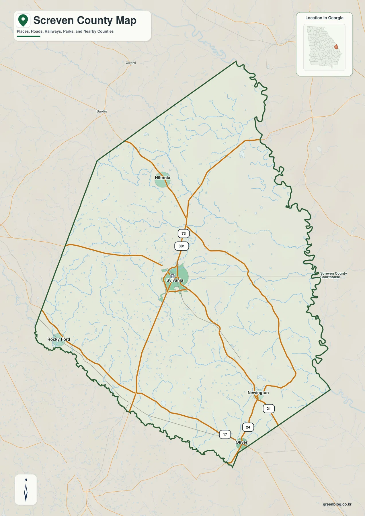
The shape of the county boundary is just as useful as the road labels. Much of the western and southern outline is comparatively straight, but the eastern edge bends repeatedly because it follows a river-defined boundary. That contrast matters when the map is used in a report or classroom setting: the county is not simply an abstract polygon. Its eastern outline reflects a major water corridor, while the interior roads cut across the county in much straighter lines. The county map is therefore the best starting point when the goal is to establish location, orientation, and the relationship between Sylvania and the county limits.
Five labeled towns reveal how dispersed settlement is
The city-connection map simplifies the county and treats Sylvania as the hub. Its lower panel lists Sylvania at 2,618 people, Hiltonia at 492, Newington at 418, Rocky Ford at 276, and Oliver at 214. These are the values printed on the supplied city map, so they are best understood as the comparison set used for this graphic rather than as a replacement for a current census table. What matters most visually is the large difference between Sylvania and the smaller incorporated places, along with the long gaps between them.
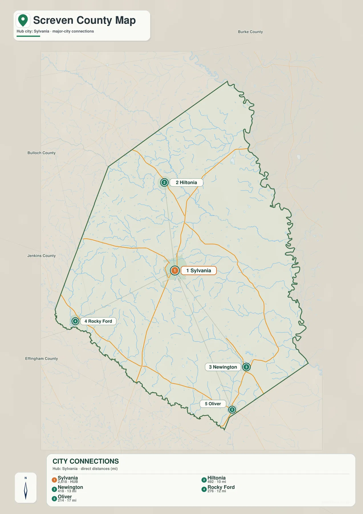
Hiltonia is shown about 10 miles from Sylvania, Rocky Ford about 12 miles, Newington about 13 miles, and Oliver about 17 miles. These are straight-line distances, not driving distances, so they should not be used to estimate travel time. They do, however, show the county’s settlement pattern clearly. Hiltonia lies north of Sylvania, Rocky Ford is to the southwest, Newington sits to the southeast, and Oliver is farther south. A reader looking only at a list of town names would miss this geometry; the connection map turns those names into a practical picture of how far apart the communities are.
The surrounding county labels add another layer of orientation. Burke County appears north of the map, Bulloch and Jenkins Counties lie to the west, and Effingham County is shown near the southwest. Those labels help explain why the road network branches in several directions instead of forming a single north-south corridor. Screven County sits between different neighboring areas while its eastern side is constrained by the river boundary.
Creeks and ponds fill the space between the Savannah and Ogeechee sides
The water map changes the county’s appearance dramatically. Instead of roads and town labels dominating the page, a dense network of small streams becomes visible. Brier Creek is one of the longest labeled interior waterways, extending through the northern and central part of the county. Buck Creek crosses the eastern half, Beaver Dam Creek appears in the northwest, and Horse Creek runs along the southwestern side. Farther south, Jackson Branch and the Ogeechee Creek–Ogeechee River system stand out. Together, these labels show that Screven County is crossed by many drainage lines rather than defined only by the Savannah River on its eastern side.
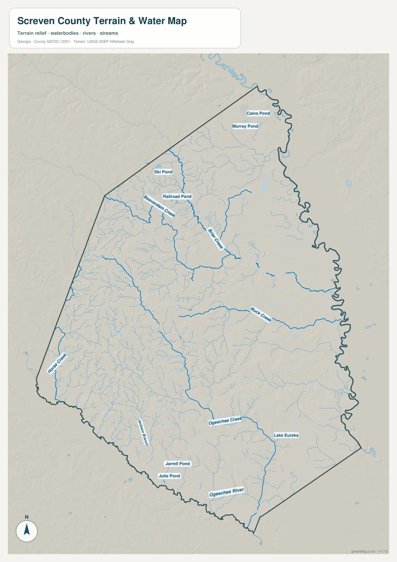
Several named ponds and small water bodies are also labeled. Cains Pond and Murray Pond sit in the northern part of the county, while Ski Pond and Railroad Pond are farther west. Jarrell Pond and Julie Pond appear near the southern edge, and Lake Eureka is labeled in the southeast. These names are not meant to be a complete inventory of every pond. Their value is that they provide recognizable reference points within a map that otherwise contains many unnamed blue lines.
Reading the streams by direction alone can be misleading because they bend with the terrain. Brier Creek curves through the north-central interior, Buck Creek follows a different eastward path, and the southern Ogeechee features occupy another low corridor. The water map is most informative when paired with the elevation view, where many of the stream lines correspond to lower green valleys. That relationship explains why the drainage network looks irregular even though the road network is comparatively direct.
Higher western ground gives way to a low eastern river margin
The elevation map uses locally scaled colors and shaded relief to separate the higher and lower parts of Screven County. Its legend gives an actual range of about 10 to 101 meters and a mean elevation of about 45 meters. That is not mountainous relief, yet the map shows meaningful local variation. The western and northwestern interior contains more brown and tan ridges, while the eastern side is dominated by green, indicating lower ground toward the Savannah River boundary.
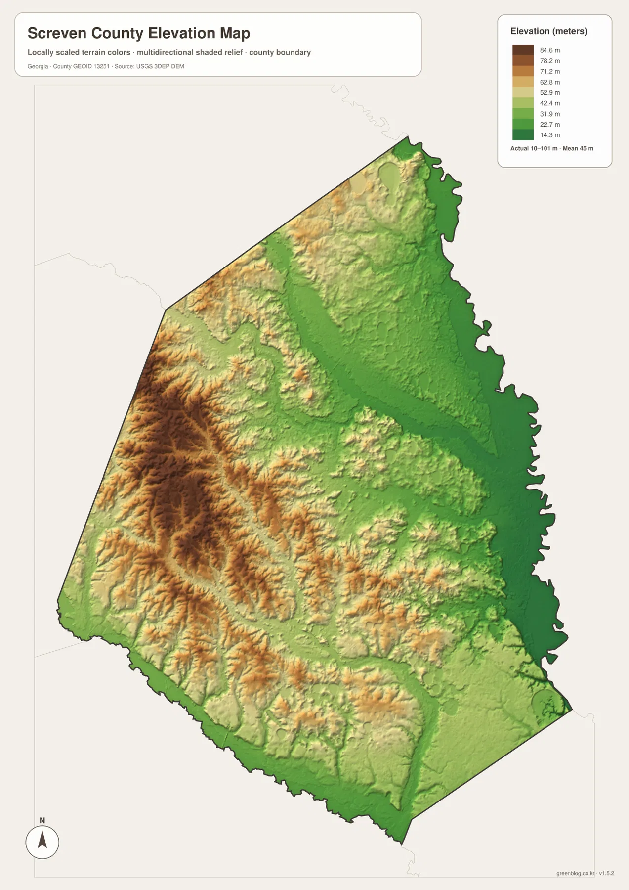
The shaded relief also shows that the higher area is not one isolated hill. It is broken into many small ridges and valleys, especially across the western half. A broad lower corridor becomes more apparent toward the east, and several stream valleys cut through the interior. The color transition therefore supports what the water map suggests: many creeks occupy the lower paths between gently rolling uplands. For a reader comparing landform and water, this map is more useful than a simple list of minimum and maximum elevations.
The difference is particularly clear when the eastern boundary is compared with the western interior. The river side stays consistently low, while the western side contains repeated pockets of higher relief. That west-to-east change is one of the most distinctive features in the four-map set and helps explain why the county outline, drainage network, and terrain should be read together rather than as unrelated layers.
What becomes clear when the four views are compared
The road map and city map emphasize human connections. Sylvania sits at the center of several route directions, while Hiltonia, Newington, Rocky Ford, and Oliver are separated from it by roughly 10 to 17 miles of straight-line distance. The water and elevation maps tell a different story. Creeks cross the same road corridors at angles, and the landscape gradually drops toward the eastern river side. When the maps are compared, the county starts to look less like a set of isolated town dots and more like a settlement network laid across rolling terrain and multiple drainage corridors.
One useful example is the central-to-northern corridor between Sylvania and Hiltonia. The general map gives 301 and 73 as simple orientation lines, but the water map shows Brier Creek and smaller tributaries crossing or paralleling parts of that area. The elevation map then adds the reason for some of that complexity: ridges and valleys are more broken in the west and northwest. The southern part offers another contrast, where the road labels around Newington and Oliver sit near lower drainage features associated with the Ogeechee side.
This is why the maps serve different jobs without being redundant. A presentation that only needs the county boundary and major places can use the general map. A discussion of settlement spacing benefits from the city map. Water-resource or local-environment context is clearer on the water map, and a terrain explanation needs the elevation map. Because all four use the same county footprint, a reader can switch between them without having to relearn the basic geography.
Choosing the map that fits the task
For classroom geography, the county map is a clear first page because it establishes Sylvania, the main labeled roads, and the unusual eastern boundary. The city map works well when the question is how the small towns relate to Sylvania or how far apart they are in a straight-line sense. The water map is the strongest choice when Brier Creek, Buck Creek, the Ogeechee features, or named ponds matter. The elevation map is best when the goal is to explain why the western interior looks hillier and why the eastern side and stream valleys sit lower.
The WEBP images in the article are optimized as on-page previews. The downloadable archive contains the four original high-resolution JPG map files, which are more appropriate for printing, saving with research notes, or placing in a larger document. Using the ZIP also keeps the four matching views together so the county boundary remains consistent across each topic.
Frequently Asked Questions
Why is the eastern county line much more winding than the other sides?
Much of that edge follows the Savannah River side, so the boundary bends with the river rather than following a long straight survey line. The contrast is easy to see by comparing the county map with the water map.
How far are the smaller towns from Sylvania on the city map?
The map gives approximate straight-line distances of 10 miles to Hiltonia, 12 miles to Rocky Ford, 13 miles to Newington, and 17 miles to Oliver. These values show relative spacing and should not be treated as road mileage or travel time.
What is the main elevation pattern to look for?
The western and northwestern interior is generally higher and more ridged, while the eastern Savannah River side and several creek valleys are lower. The elevation legend shows an actual county range of about 10 to 101 meters and a mean of about 45 meters.
Map File Information
The ZIP includes four high-resolution A3 JPG maps of Screven County covering the county layout, city connections, water features, and elevation.
- Included Files: County map, city map, water map, elevation map
- File Type: Four high-resolution A3 JPG files in one ZIP
Related Maps
Sources and data references
These links provide county background and official national sources for boundary, hydrography, and elevation data when a more detailed dataset is needed beyond the map previews.
- U.S. Census Bureau QuickFacts for Screven County
- New Georgia Encyclopedia: Screven County
- U.S. Census Bureau TIGER/Line Shapefiles
- USGS National Hydrography
- USGS 3D Elevation Program
Green Map creates custom-edited map images using open geographic data sources such as geoBoundaries, Natural Earth, OpenStreetMap, and government open data. These maps are edited visual materials, not raw data files, and are provided for education, documents, presentations, and graphic reference.