Brazos County is easiest to understand from the Bryan–College Station urban area and then outward toward the rivers and smaller communities around it. Bryan, the county seat, sits directly north of College Station, while Wixon Valley and Kurten provide smaller reference points farther north and northeast. The Brazos River bends along the western and southwestern side of the county, and the Navasota River follows the eastern edge, placing the main urban area between two large river systems. This page includes a county map, a city-connections map, a terrain-and-water map, and an elevation map. The same four maps are available here as high-resolution A3 JPG files in a downloadable ZIP.
For a quick orientation, start with State Highway 6 through Bryan and College Station. State Highway 21 approaches Bryan from the west, State Highway 30 extends east from the urban area, and US 190 is visible toward Kurten in the northeast. Once those roads are located, the county’s shape makes more sense: the densely mapped urban core occupies the middle portion, smaller settlements lie beyond it, and lower river corridors frame much of the east and southwest. Reading the four supplied maps together makes those differences easier to see without treating any one map as a complete description of the county.
Table of Contents
Bryan–College Station as the Main Map Reference
The county map gives Bryan and College Station the strongest visual presence. Bryan occupies the northern side of the connected urban area, with College Station immediately to the south. The two cities are close enough that their developed areas appear continuous at this scale, yet the labels and road network still make their separate centers clear. North of the urban core, Wixon Valley is marked as a smaller community, while Kurten lies to the northeast along the general US 190 corridor. Together, these four places provide a useful set of reference points for locating the rest of Brazos County.
Several major roads converge around the two cities. State Highway 6 is the clearest north-south route, passing through Bryan and College Station before continuing toward the southeast. State Highway 21 reaches Bryan from the west, and State Highway 30 leaves the College Station side toward the east. US 190 appears farther north and northeast near Kurten. The map is not intended to replace a navigation app, but it clearly shows which directions connect the urban area with the surrounding county and neighboring regions.
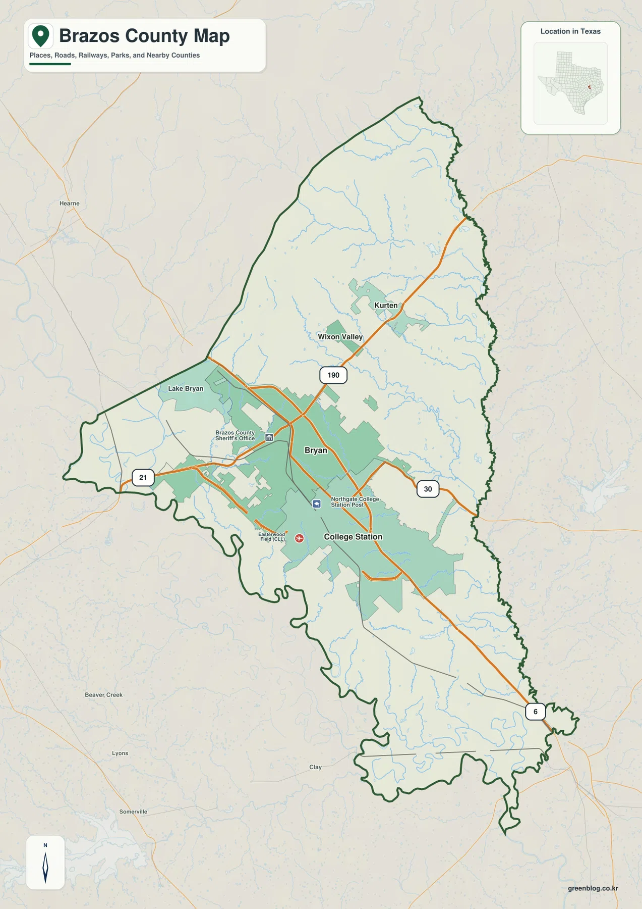
The surrounding counties help with orientation as well. Robertson County lies to the north, Madison County and Grimes County are on the eastern side, Washington County is to the southwest, and Burleson County is to the west. The Brazos and Navasota rivers are especially useful geographic markers because they run along opposite sides of much of the county. Instead of memorizing every boundary segment, a reader can use the urban core, the two rivers, and the major highways to keep the county’s position organized.
Straight-Line Distances from College Station
The city-connections map uses College Station as its hub and compares selected communities by direct distance. Bryan is shown at about 6 miles from College Station, Wixon Valley at about 12 miles, and Kurten at about 14 miles. These are straight-line distances, not driving distances. A road trip between the same places may be longer because streets and highways do not follow a perfectly direct path, so the map is best used to compare general spacing and direction rather than travel time.
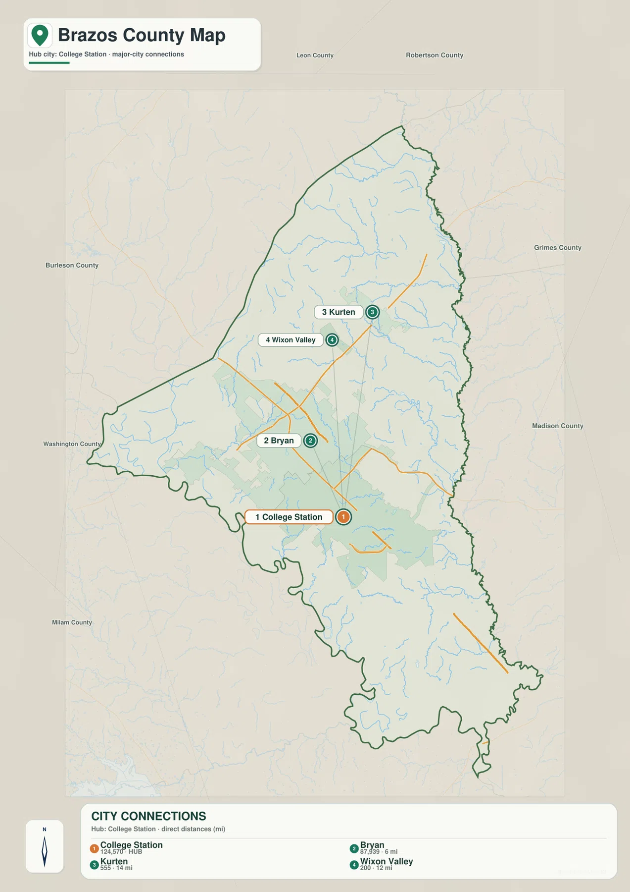
The map also shows how differently those communities relate to the central urban area. Bryan is directly adjacent to College Station, while Wixon Valley is farther north and Kurten is northeast. That directional difference matters more than the small difference between 12 and 14 miles. On the county map, the Bryan–College Station area contains a much denser set of roads and developed shading, whereas the land around Kurten and Wixon Valley is more open and crossed by numerous small streams.
This city view is intentionally selective. It does not attempt to label every neighborhood, facility, lake, or minor road. For that level of detail, the general county map is more useful. The city-connections version works best when a reader wants a simple answer to questions such as which community is closest to College Station or whether Kurten lies north, east, or west of the main urban area.
Two Large Rivers and a Dense Network of Creeks
The terrain-and-water map changes the emphasis from roads to drainage. The Brazos River follows the western and southwestern side of the county, while the Navasota River runs along the eastern edge. Between them, a fine network of tributaries covers much of the interior. Cedar Creek is labeled in the north, Wickson Creek crosses the central area, and Thompson Creek appears west of the urban core. Big Creek is labeled in the southeast. The result is a county whose interior is divided by many smaller channels even though the two largest rivers sit mainly along its outer sides.
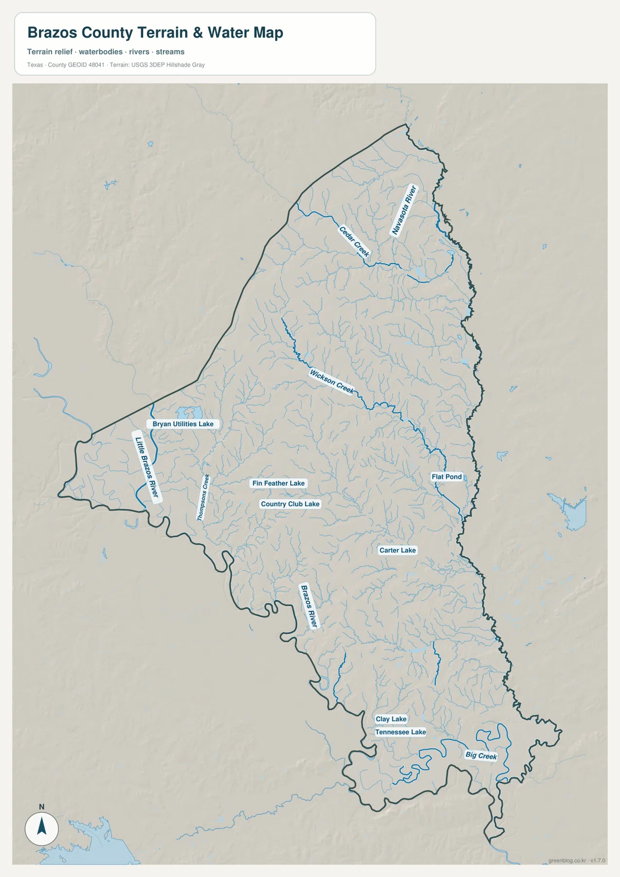
Several smaller water bodies provide additional landmarks. Bryan Utilities Lake is labeled west of the urban area, while Fin Feather Lake and Country Club Lake appear near the center. Carter Lake lies farther southeast, and Clay Lake and Tennessee Lake are marked in the southern part of the county. Flat Pond appears toward the east. These labels are useful when matching a local area to the water map, but the display should not be treated as a flood-hazard map or a statement about water depth, navigation, property boundaries, or legal access.
One useful comparison is the position of Bryan and College Station relative to the two major rivers. The cities are not drawn directly on either large river; instead, they occupy the interior between the Brazos on the west and the Navasota on the east. Smaller creeks cross that interior and lead toward lower ground. This helps explain why the water map looks much more intricate than a simple outline showing only the two major rivers.
A 43–132 Meter Range with Higher Interior Ridges
The supplied elevation map reports an actual range of about 43 to 132 meters and a mean elevation of about 85 meters. Higher brown and tan areas are concentrated through much of the central and northwestern interior. Lower green terrain follows the eastern side near the Navasota River and appears along the western and southwestern Brazos River corridor as well. The southern tip is also relatively low. Brazos County is not mountainous, but the shaded relief makes a repeating pattern of modest ridges and lower stream valleys visible across the county.
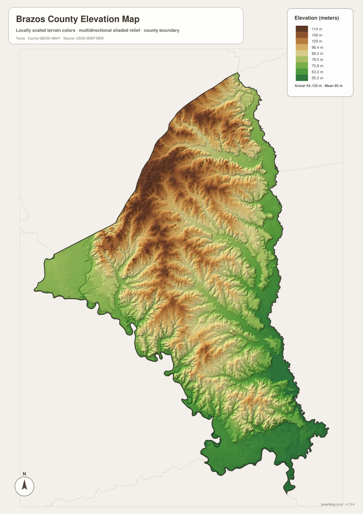
Comparing the elevation and water maps is particularly helpful. On the eastern side, the broad lower band corresponds with the Navasota River corridor. Lower terrain also follows much of the Brazos River side in the west and southwest. Between those edges, the shaded relief shows higher ridges separated by narrow valleys that often contain smaller streams. The color boundaries are visual classes rather than abrupt cliffs, so neighboring shades should be understood as gradual changes in elevation.
This elevation layer is designed for county-scale comparison, not engineering or surveying. It should not be used to determine the exact elevation of a house, parcel, road crossing, drainage structure, or construction site. More detailed official elevation data and field measurements are necessary for those tasks. For general orientation, however, the map clearly shows that the county’s rivers occupy lower terrain while much of the interior rises above them in a series of gentle ridges.
How Roads, Rivers, and Relief Fit Together
The four maps become more useful when the same place is followed from one layer to another. Start with Bryan and College Station on the county map, then locate the same central area on the water map. The Brazos River is well to the west and southwest, while the Navasota River is on the eastern edge. Move to the elevation map and the urban area falls between the broad low river corridors rather than directly inside the lowest bands. That sequence gives a clearer geographic picture than reading road, water, or elevation information in isolation.
Kurten provides another example. It is northeast of the main urban area on the county and city maps. On the water map, the northern and northeastern part of the county contains numerous tributaries leading toward the Navasota system, including Cedar Creek farther north. On the elevation map, nearby ridges and lower drainage lines alternate rather than forming one flat surface. The maps therefore show why a short straight-line distance does not mean that every part of the route has the same terrain or follows the same type of road.
Choosing the Best Map for the Question
Use the general county map when the question involves named places, highway directions, or the county outline. It is the most useful starting point for locating Bryan, College Station, Kurten, Wixon Valley, Lake Bryan, and the main road corridors. The city-connections map is better for a quick comparison of the selected communities around College Station, especially when the reader wants the direct distance and direction without the extra road detail.
For natural features, switch to the terrain-and-water map. It makes the Brazos and Navasota rivers, named creeks, lakes, ponds, and the dense stream network much easier to see. The elevation map answers a different question by showing where the county is higher or lower within its 43–132 meter range. None of these maps replaces a survey, flood study, navigation chart, or detailed road-routing service, but together they provide a practical county-level overview for learning, printing, and general reference.
Printing and Downloading the High-Resolution Maps
The downloadable archive contains the same four map types used on this page as high-resolution A3 JPG files. The larger files are useful when the web previews are too small for a printed handout, classroom display, presentation, or personal map project. Because the maps emphasize different information, a reader can print only the county map for a road-and-place overview, pair the water and elevation maps for a physical-geography lesson, or use the city version when relative community spacing is the main topic.
When printing, keep the legend and labels visible rather than cropping tightly around the county boundary. The city map’s mileage values are direct distances, and the elevation map’s colors represent a generalized county-scale surface, so those explanatory elements are part of the information. The water map should likewise be treated as a location reference rather than a flood or navigation product.
Frequently Asked Questions
How far is Bryan from College Station on the city map?
The city-connections map shows Bryan at about 6 miles from College Station. That number is a straight-line distance between the mapped points, not a driving distance along streets or highways. The county map also shows how closely the two developed areas sit next to one another.
Where are the Brazos and Navasota rivers in Brazos County?
The Brazos River follows the western and southwestern side of the county, while the Navasota River runs along the eastern edge. Bryan and College Station lie in the interior between the two major rivers, with many smaller creeks crossing the county toward lower ground.
What does the Brazos County elevation map show?
The supplied map shows elevations from about 43 to 132 meters, with a mean of about 85 meters. The central and northwestern interior is generally higher, while lower terrain appears along the Navasota River side, the Brazos River corridor, and parts of the south. It is a county-scale reference rather than survey-grade elevation data.
Map File Information
Download the four Brazos County maps used on this page in one ZIP. The archive contains high-resolution A3 JPG files for the county map, city map, water map, and elevation map.
- Included Files: County map, city map, water map, elevation map
- File Type: ZIP containing four high-resolution A3 JPG files
Related Maps
- Robertson County Texas map
- Washington County Texas map
- Walker County Texas map
- Waller County Texas map
- Anderson County Texas map
Sources and References
- U.S. Census Bureau TIGER/Line Shapefiles — official geographic files for county boundaries, roads, and related features.
- USGS National Hydrography — U.S. Geological Survey information for rivers, streams, and hydrographic data.
- USGS 3D Elevation Program — official information about U.S. elevation data and 3DEP.
- USGS The National Map Viewer — an interactive reference for boundaries, hydrography, roads, and terrain.
Green Map creates custom-edited map images using open geographic data sources such as geoBoundaries, Natural Earth, OpenStreetMap, and government open data.
These maps are edited visual materials, not raw data files, and are provided for education, documents, presentations, and graphic reference.