Download the Brazoria County map set directly from this page as a ZIP containing four high-resolution A3 JPG files: a general county map, city map, water map, and elevation map. Brazoria County stretches from the southern edge of the Houston metropolitan area to the Gulf Coast, so the county changes noticeably from north to south. Pearland and Alvin anchor the more urbanized northern section, Angleton sits near the middle as the county seat, and Lake Jackson, Clute, and Freeport form a separate concentration closer to the coast. The Brazos River, San Bernard River, bayous, bays, and broad lowlands add another layer that is easy to miss on a city-only map, while the four views together make the county’s roads, settlements, waterways, and low coastal terrain easier to compare.
A useful way to orient yourself is to start with Pearland and Alvin in the north, move south to Angleton, and then continue toward Lake Jackson and Freeport. That sequence makes it clear that Brazoria County is not organized around a single compact urban core. Its northern communities face toward Houston, its central area provides the administrative reference point, and its southern communities sit within a landscape shaped by the Brazos River and the Gulf. State Highway 288, State Highway 35, and State Highway 36 help connect these parts, while the water and elevation maps explain why the southern half looks much more intricate than a simple road map suggests.
Table of Contents
From Pearland to Freeport: the county’s clearest north–south line
The general county map makes the north–south relationship especially easy to follow. Pearland appears near the northeastern edge of Brazoria County, with Manvel and Iowa Colony close by and Alvin farther east. Angleton occupies a more central position. South of the county seat, Richwood, Lake Jackson, and Clute sit close together before the map reaches Jones Creek, Oyster Creek, and Freeport near the coast. These place names show two distinct concentrations of settlement rather than an even spread of cities across the county.
State Highway 288 provides the most obvious transportation link through this pattern. It runs from the Houston direction through Pearland and Manvel, continues toward Angleton, and then leads into the Lake Jackson–Clute–Freeport area. State Highway 35 crosses Angleton on an east–west course, connecting toward Alvin on one side and Brazoria on the other. State Highway 36 is prominent farther southwest and south, helping connect Brazoria with communities near the lower part of the county. Reading these routes together is more informative than treating each highway as an isolated line because the junctions show how the northern suburbs, county seat, inland communities, and coastal cities are tied together.
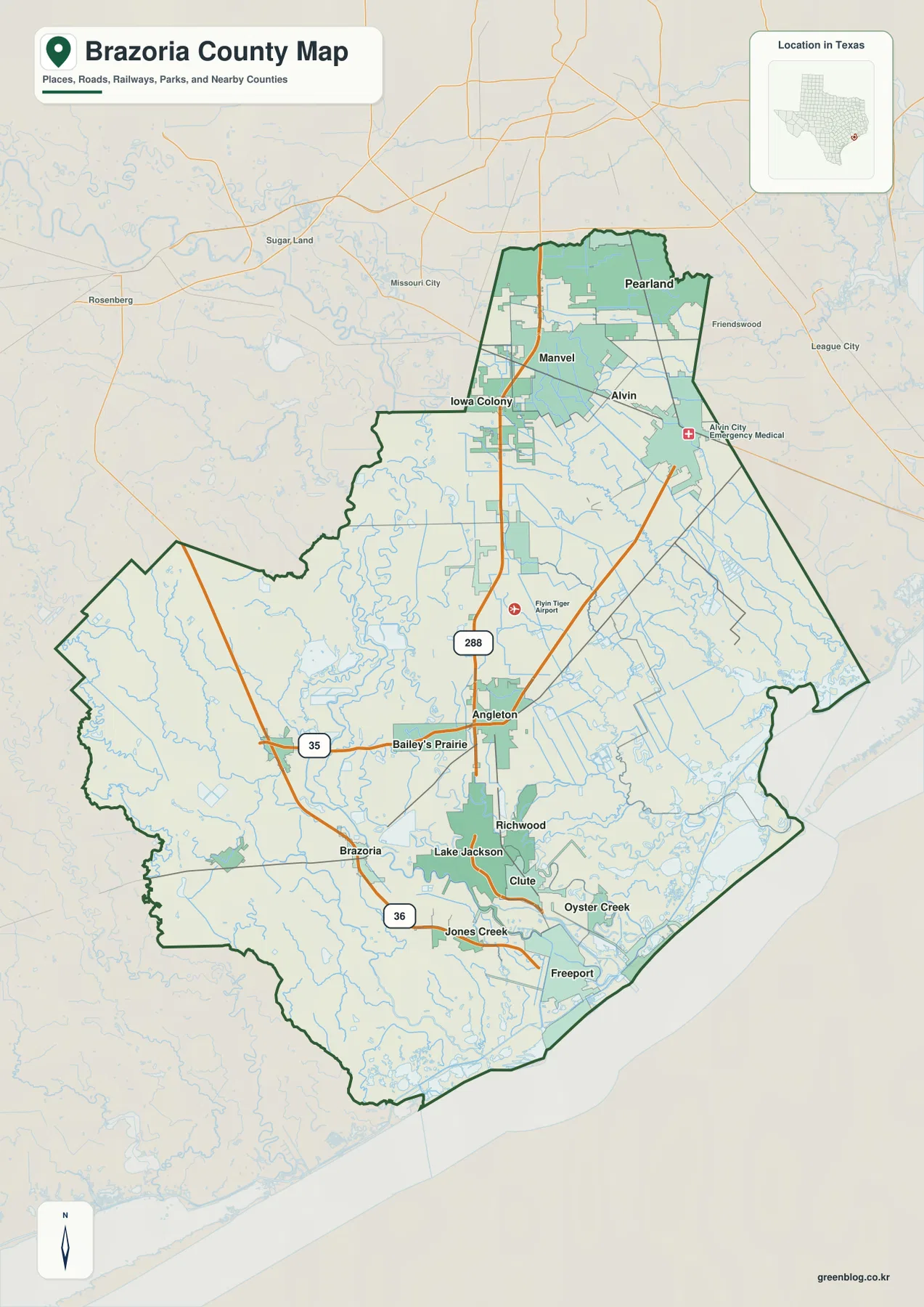
The outer edges of the map add useful regional context. Brazoria County connects toward Fort Bend and Harris counties on the Houston side, Galveston County to the east, and Wharton and Matagorda counties toward the west and southwest. Pearland is therefore a very different geographic reference point from Freeport. Pearland lies close to the metropolitan fringe and major northbound travel, while Freeport sits at the opposite end of the county near the Gulf and the lower Brazos area. Keeping those two ends in mind prevents a large county from being reduced to a single “south of Houston” label.
A northern suburban cluster and a separate southern city group
The city map ranks six major communities and also shows how far apart they are. Pearland is the largest city in the supplied ranking, followed by Alvin, Lake Jackson, Angleton, Manvel, and Iowa Colony. The ranking alone is useful, but the placement is even more revealing. Pearland, Manvel, Iowa Colony, and Alvin are all in the northern part of Brazoria County. Angleton is farther south and more central, while Lake Jackson stands apart in the southern section. That gap between the northern cluster and the southern cities is one of the defining features of the county’s settlement pattern.
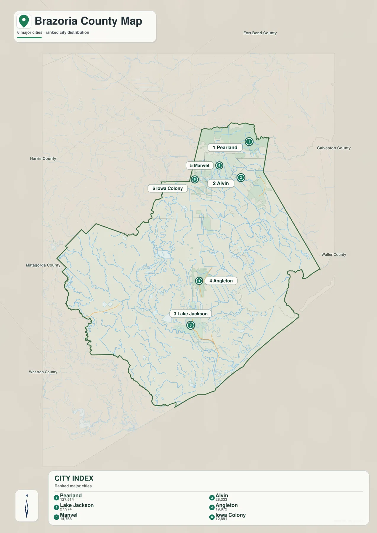
Angleton is especially important because it is the county seat even though it is not the largest city. The official Brazoria County government offices and courthouse are in Angleton, making the city the administrative reference point near the middle of the county. Pearland, by contrast, is much larger and is closely tied to the Houston side of the county. Lake Jackson helps define the southern urban group, while the general county map adds nearby Richwood, Clute, Freeport, Oyster Creek, and Jones Creek. Looking at both city views prevents population rank from being confused with government function or with geographic centrality.
The simplified city view is best for comparing major locations, not for finding every community or road. Smaller places such as Bailey’s Prairie or Brazoria become easier to locate on the general county map, and the detailed relationship among Lake Jackson, Clute, Richwood, and Freeport is clearer there as well. For a presentation or classroom exercise, the city ranking provides a clean overview. For travel planning or a closer geographic comparison, the road map should be used alongside it.
Brazos River, San Bernard River, bayous, and the Gulf edge
Water is one of the strongest visual features of Brazoria County. The Brazos River crosses the interior in large bends before reaching the Gulf area, while the San Bernard River follows a separate course through the western side. Between and around them, the water map labels Oyster Creek, Mustang Bayou, Chocolate Bayou, and Bastrop Bayou. Near the eastern coast, Bastrop Bay and West Bay add broad open-water shapes that contrast with the narrow inland streams. The result is a county whose southern half is defined by a dense network of rivers, bayous, channels, and coastal water.
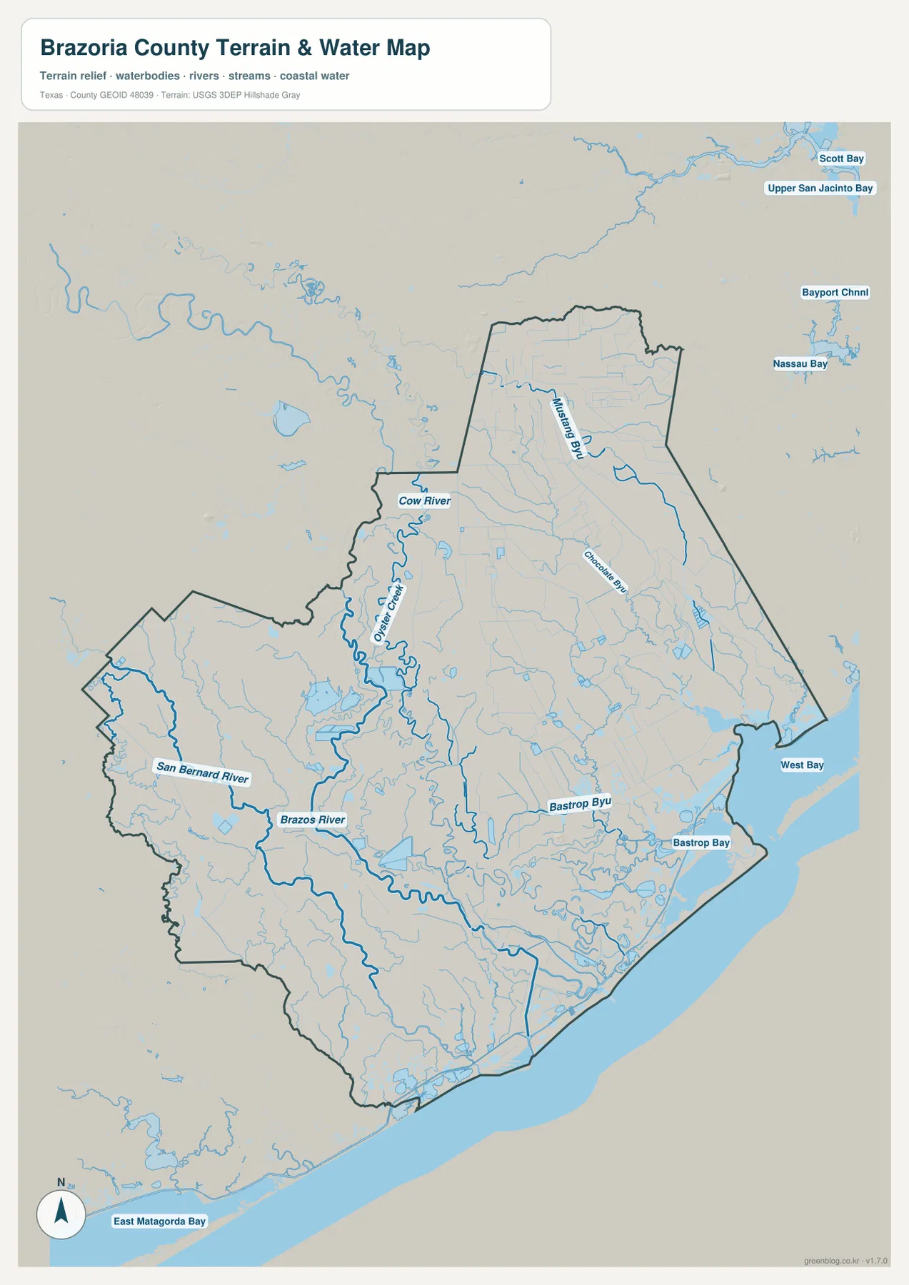
The Brazos River is especially useful as a geographic reference because it cuts through the county rather than simply tracing an outside border. Its bends help separate parts of the central and southern landscape, and many smaller channels appear around it. The San Bernard River does something similar farther west. On the eastern side, Chocolate Bayou and Bastrop Bayou lead toward coastal waters, while West Bay marks a much broader marine edge. This arrangement explains why southern Brazoria County looks more complex on a water map than on a simplified city map.
This layer should not be treated as a flood-zone or navigation chart. It does not tell a property owner whether a particular parcel will flood, nor does it provide channel depths or legal water boundaries. Its purpose is geographic orientation: identifying named rivers and bayous, seeing how they approach the Gulf, and understanding why roads and settlements in the lower county occupy a landscape with many water crossings. For those questions, it is the most informative of the four supplied views.
A very low coastal plain with slightly higher inland ground
The elevation map confirms that Brazoria County is a low-relief Gulf Coast landscape. The map notes an actual elevation range of about -10 to 43 meters and a mean near 8 meters. Most of the county therefore sits at modest elevations, with no mountain belt or steep upland dividing the communities. Even so, the color pattern shows a broad difference: warmer brown and tan tones are more common across the northwestern and inland side, while green lowlands dominate much of the south and east toward the coast.
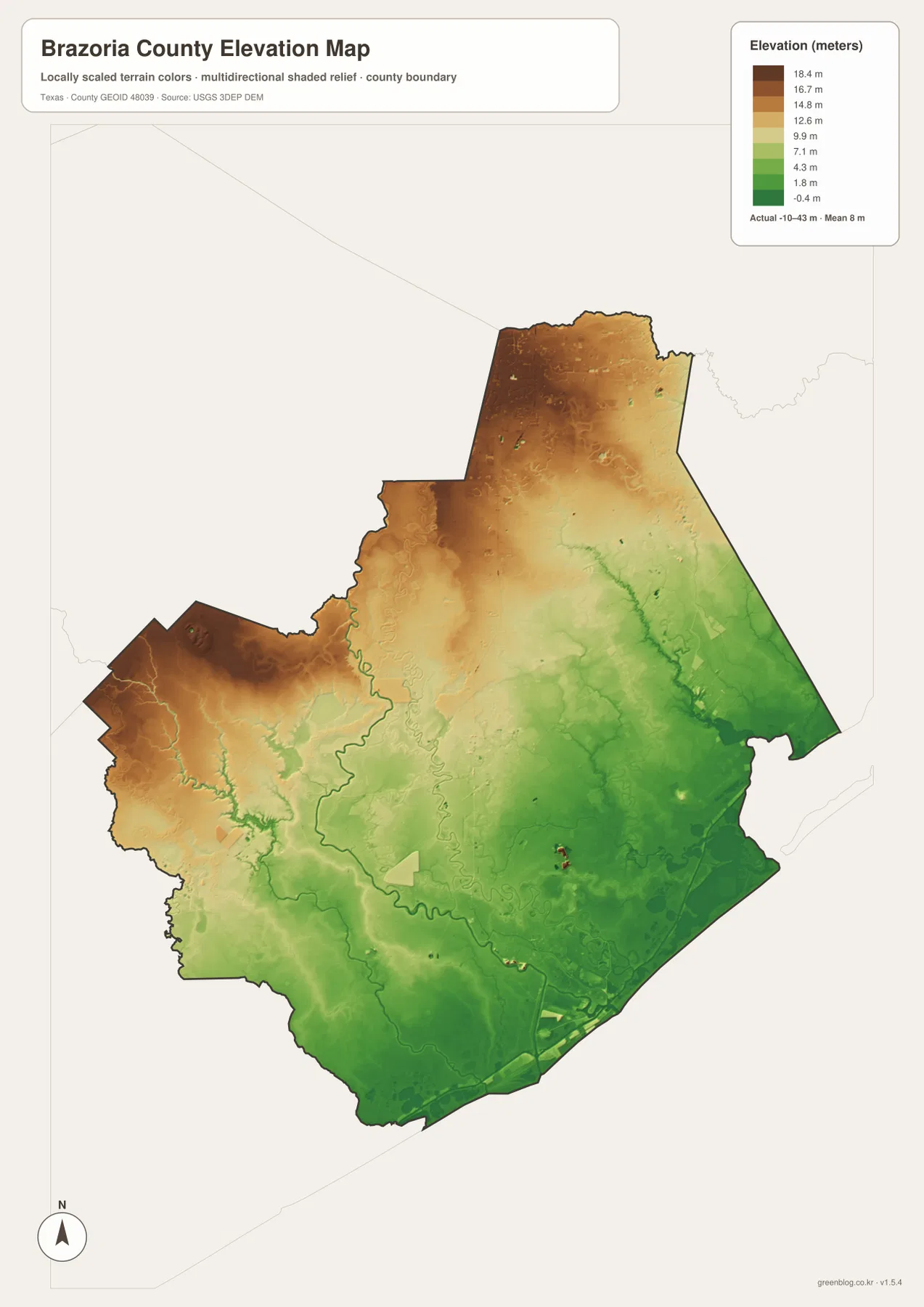
The transition is gradual. The northwest does not rise into a dramatic ridge; it simply sits higher than the broad green coastal plain. Lower bands also follow parts of the Brazos River and other drainage corridors, which become easier to recognize when the elevation and water maps are compared. Near the Gulf and West Bay, very low terrain covers large areas. That relationship between flat relief and abundant water is one reason the southern half of the county looks so different from the northern suburban area on the map.
The elevation layer is intended for county-scale comparison, not parcel-level decisions. A color or value on this map should not replace a survey, engineering data, or an official flood map. It is most useful when the question is broad: Which side of the county is generally higher? Where do the river corridors sit relative to surrounding land? Why does the coastline merge into such a wide lowland? For these purposes, the shaded surface adds information that a road map cannot provide.
Why Angleton works as the best central reference point
Angleton makes a practical starting point because it combines administrative importance with a central map position. From Angleton, Highway 288 leads north toward Manvel and Pearland and south toward Lake Jackson, Clute, and Freeport. Highway 35 crosses the county seat toward Alvin in the east and Brazoria in the west. A reader who locates Angleton first can therefore organize the county into four directions without memorizing every small community.
The surrounding natural features make that reference even more useful. The Brazos River bends through the central and southern part of the county, while Oyster Creek and several smaller channels appear nearby. Continuing south from Angleton brings the map into a denser network of water features and closely spaced communities around Lake Jackson and Freeport. Moving north does the opposite: the map becomes more strongly associated with the Houston-facing suburbs and the Highway 288 corridor. That changing context on either side of Angleton is more informative than simply saying that the city is “in the middle.”
Choose the map by the question you need to answer
Use the general county map when you need roads, community names, the county outline, and surrounding areas in one place. Use the city map when the main task is comparing Pearland, Alvin, Lake Jackson, Angleton, Manvel, and Iowa Colony without extra detail. The water map is the strongest choice for the Brazos River, San Bernard River, Oyster Creek, Chocolate Bayou, Bastrop Bayou, and coastal bays. The elevation map adds a different answer by showing the broad decline from somewhat higher inland ground toward the low Gulf plain.
Combining two views often works better than expecting one map to answer everything. For Freeport, begin with the general map to locate the southern road network, then switch to the water map to see the Brazos River mouth and nearby Gulf waters. For Pearland, the city view quickly establishes its size and northern position, while the road map shows how Highway 288 connects it toward Houston and the rest of Brazoria County. For Angleton, start with the highway junctions and then compare the water and elevation layers to understand the surrounding lowland setting.
A Gulf Coast county whose geography changes before you reach the shoreline
Brazoria County is often described simply as being south of Houston, but the maps show why the Gulf Coast is just as important to its identity. The Texas State Historical Association places the county on the Gulf Coast prairie at the mouth of the Brazos River and identifies the Brazos and San Bernard rivers, Oyster Creek, Bastrop Bayou, and Chocolate Bayou among its principal waterways. Those names are visible in the supplied water map, where the southern half becomes increasingly complex as streams, bayous, and bays approach the Gulf.
The settlement pattern mirrors that geographic change. Pearland is part of the Houston-facing northern edge, Angleton provides a central county-government reference, and the Lake Jackson–Clute–Freeport area belongs to a much more coastal setting. Between them are rural tracts, river corridors, smaller towns, and extensive low ground. This is why Brazoria County benefits from several map types rather than a single outline: the city distribution, road network, water system, and relief each reveal a different part of the same county.
Frequently Asked Questions
Is Pearland the county seat because it is the largest city on the map?
No. Angleton is the county seat of Brazoria County. Pearland is the largest city in the supplied city ranking and is an important northern suburban center, but county government is based in Angleton near the middle of the county.
Which map is best for the Brazos River and Gulf Coast waterways?
The water map is the best choice because it shows the Brazos River and San Bernard River along with Oyster Creek, Chocolate Bayou, Bastrop Bayou, West Bay, and other coastal water features. It provides more hydrographic detail than the general road-and-city view.
Is Brazoria County flat?
It is generally a very low, gently changing coastal plain. The supplied elevation map reports a mean near 8 meters and shows somewhat higher ground in the inland northwest, with lower terrain along river corridors and toward the southern and eastern coast. The map is suitable for broad terrain comparison, not for property-level elevation or flood decisions.
Sources and Reference Data
- Brazoria County official website: official county-government information and the Angleton courthouse location.
- Texas State Historical Association – Brazoria County: regional setting, communities, highways, rivers, and Gulf Coast geography.
- U.S. Census Bureau TIGER/Line Shapefiles: official U.S. geographic files for boundaries, roads, and related features.
- USGS National Hydrography: authoritative reference for U.S. rivers, streams, and other hydrographic features.
- USGS 3D Elevation Program: official information about national elevation and terrain data.
Map File Information
Download the map files associated with this page for reference, printing, and compatible visual projects.
- Included Files: Use only the versions confirmed in the article and supplied images
- File Type: Use the confirmed download contents
- Intended Use: Printing, education, presentations, and map-based projects
Related Maps
Green Map creates custom-edited map images using open geographic data sources such as geoBoundaries, Natural Earth, OpenStreetMap, and government open data.
These maps are edited visual materials, not raw data files, and are provided for education, documents, presentations, and graphic reference.