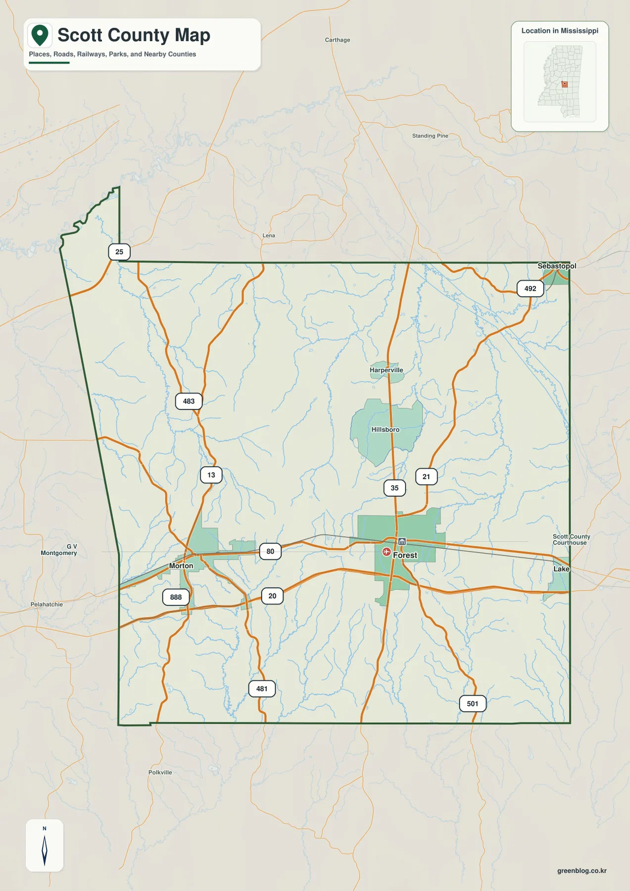
Scott County Mississippi map files are available to download directly from this page. The four supplied views cover the county boundary and roads, selected city connections, water features, and elevation, with Forest, Morton, Lake, Sebastopol, and Hillsboro providing clear place references. I-20 and US 80 form the strongest east-west route across the county, while Little River, Strong River, and numerous creeks occupy lower valleys between wooded hills. The download ZIP contains all four maps as high-resolution A3 JPG files for printing, editing, classroom use, or location-reference graphics.
Scott County lies in central Mississippi and is easiest to understand from Forest, the county seat. Morton is west of Forest along the I-20 corridor, Lake is farther east toward Newton County, and Sebastopol and Hillsboro provide northern reference points. The landscape is not dominated by one broad river valley or a single mountain ridge. Instead, rolling hills are repeatedly cut by small streams, and the relief becomes stronger toward the southern half. Comparing the road, water, and elevation views makes that transition much clearer than a boundary map by itself.
Table of Contents
Forest and Morton along I-20 and US 80
The general county map is easiest to read from I-20. The interstate enters from the Rankin County side, passes Morton, continues just south of Forest, and then runs toward Lake and Newton County. US 80 follows the same broad east-west direction and gives another useful reference between Morton and Forest. Once those two cities are located, the rest of the county’s road pattern becomes much easier to follow.
MS 35 runs north from the Forest area toward Hillsboro and Harperville and also continues south. MS 21 appears east of Forest, while MS 501 reaches into the southeastern part of the county. West and northwest of Forest, MS 13 and MS 483 help connect the Morton side with the northern interior. MS 492 is visible near Sebastopol in the northeast. Rather than memorizing every route number, it is simpler to treat I-20 and US 80 as the horizontal reference and MS 35 as one of the main north-south connections through the county.
The map also helps place Scott County among its neighbors. Rankin County is to the west, Newton County to the east, Leake County to the north, and Smith, Jasper, and Neshoba counties appear around the southern and eastern sides. Morton is the clearest western community before the Rankin County direction, while Lake provides a useful eastern reference toward Newton County. Those relationships matter when reading a county that has several small communities but no single city occupying most of the map.
Morton and Sebastopol measured from Forest
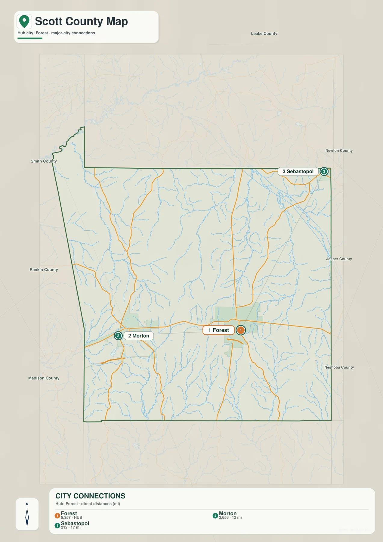
The city-connections map simplifies the county to three selected communities. Forest is the hub, Morton lies to the west, and Sebastopol is far to the northeast. The map labels the direct distance from Forest to Morton as about 12 miles and the distance from Forest to Sebastopol as about 17 miles. These are straight-line distances between the mapped points, not road mileage, so actual driving distances will be longer and depend on the route used.
The same map lists Forest at 5,357 residents, Morton at 3,656, and Sebastopol at 212. Those numbers are useful for comparing the scale of the selected communities but should not be confused with the total population of Scott County. Forest clearly receives the strongest emphasis, Morton forms a second substantial community on the west side, and Sebastopol works mainly as a geographic anchor for the northeastern corner.
Lake and Hillsboro appear on the general county map but are not part of this three-place city panel. That difference is useful rather than a gap. The general map is better when a reader needs more place names and roads, while the city-connections view answers a narrower question: where are Morton and Sebastopol in relation to Forest, and how far apart are those selected points?
Little River, Strong River, and a dense creek network
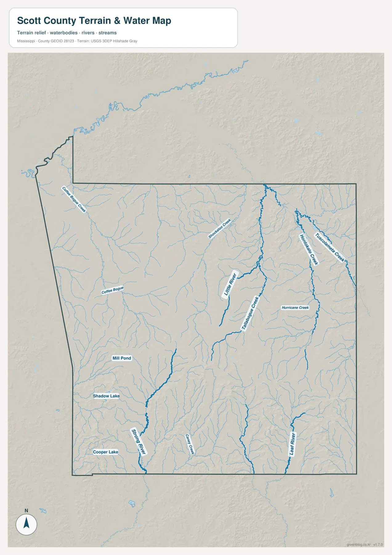
The water map shows a county divided by many small drainage valleys rather than one dominant river. Little River is one of the strongest named channels in the central-eastern area. Shockaloe Creek and Tallabogue Creek feed through nearby terrain, while Thornton Creek, Tuscumbia Creek, and Hurricane Creek form separate north-south drainage lines farther east. Their spacing matches the repeated ridge-and-valley pattern visible on the elevation map.
The western half has a different group of named waterways. Coffee Bogue and Coffee Bogue Creek appear in the west and northwest. Strong River becomes prominent in the southern section, and Leaf River is labeled near the southeastern edge. These larger channels occupy low corridors between higher hills and give the southern part of Scott County a more broken appearance than the flatter-looking northern interior.
Several small water bodies are also labeled. Mill Pond, Shadow Lake, and Cooper Lake appear in the western and southwestern half of the map. The supplied existing material also uses Roosevelt State Park near Morton as a local recreation and water reference, but this map is not a park-boundary map. It is designed to show rivers, creeks, lakes, and terrain, so current park facilities and exact management boundaries should be checked with the official park source.
This water view is intended for general geographic reference. It is not a flood-insurance map, parcel survey, water-quality assessment, or navigation chart. Its main value here is showing where Little River, Strong River, and the named creeks run through the county and how those waterways relate to the surrounding terrain.
Higher southern hills above lower stream valleys
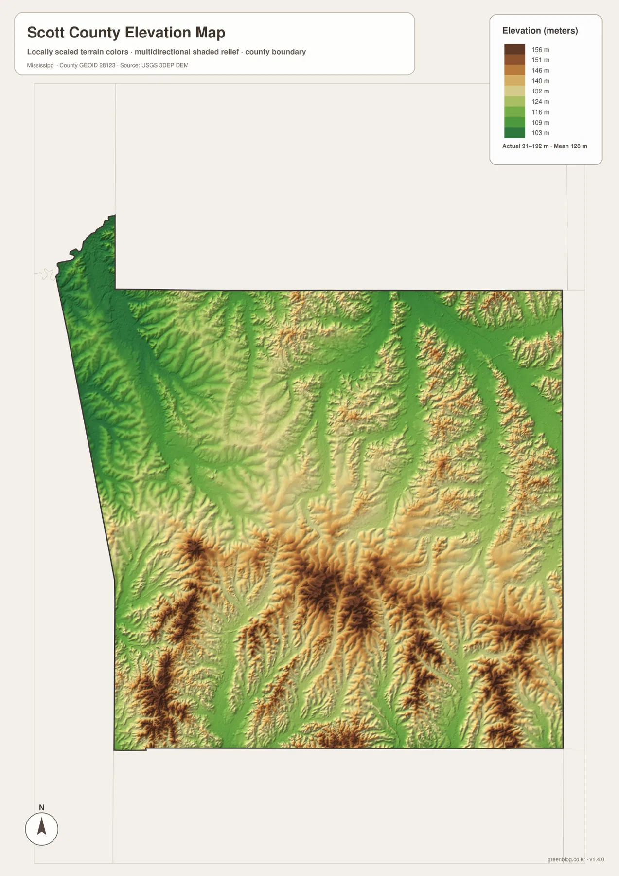
The elevation map prints an actual range of about 91 to 192 meters and a mean elevation of about 128 meters. The strongest brown relief is concentrated across the south and southeast, where closely spaced ridges create a rougher surface. Northern and northwestern parts of the county contain more green terrain, and lower corridors also extend through the center and east along the main drainage lines.
Comparing the elevation and water maps makes the pattern easy to recognize. Little River and Tallabogue Creek occupy lower channels between ridges, and Thornton Creek and Hurricane Creek follow additional low valleys farther east. Strong River in the southwest also cuts through terrain that is lower than many of the surrounding hills. The result is a landscape of wooded ridges separated by narrow stream valleys rather than a single broad flat basin.
The existing article refers to Bienville National Forest as an important landscape reference for the southern and southeastern forest country. That does not mean the entire county is national forest. The forest lands are not shown here as a legal ownership layer, so readers who need precise management boundaries should use a dedicated official forest map. On this page, the elevation view is best used to understand the broad hill-and-valley pattern.
The elevation surface is generalized for county-scale comparison and is not survey-grade data. It should not be used to determine the exact elevation of a building site, calculate road grade, design drainage, or make a construction decision. Its practical role is to show where the highest-looking southern ridges stand above the lower stream corridors.
Population and area put the map scale in context
The supplied Census references list 27,990 residents in the 2020 census and a July 2025 estimate of 28,073. These values use different dates and methods, so they are better read as separate benchmarks rather than measurements taken under identical conditions. Together with the city map, they show a county where Forest and Morton are the largest selected communities but a substantial share of the land remains rural and forested.
The supplied 2025 Gazetteer figures list 609.231 square miles of land and 1.159 square miles of water. Using the 2020 population and that land area gives roughly 45.9 residents per square mile, but that is only a countywide average. Residents are not evenly distributed across Forest, Morton, Lake, national-forest lands, farms, roads, and stream valleys. The maps make the uneven settlement pattern more useful than the average density alone.
Choosing the best Scott County map for the task
Use the general county map when the boundary, I-20, US 80, Forest, Morton, and Lake need to appear together. The city-connections map is better for comparing Forest with Morton and Sebastopol and for using the printed straight-line distances. Choose the water map when Little River, Strong River, the named creeks, or the small lakes are the main subject. The elevation map is the clearest option for explaining why the south and southeast contain stronger hill relief than the north. In a presentation, pairing the general map with the elevation map works especially well because it connects roads and settlements with the terrain beneath them.
Frequently Asked Questions
Is Roosevelt State Park in Forest?
The supplied existing material places Roosevelt State Park near Morton rather than in Forest. Forest lies farther east and serves as the county seat. Current park facilities, access, and operating information should be checked with the Mississippi Department of Wildlife, Fisheries, and Parks.
Does Bienville National Forest cover all of Scott County?
No. The supplied material treats Bienville National Forest as an important southern and southeastern landscape reference, not as a continuous ownership layer covering the entire county. This page does not map legal forest boundaries, so a dedicated official forest source is required for precise management areas.
Where is the higher terrain in Scott County?
The supplied elevation map shows the strongest high ground across the south and southeast. Its actual range is about 91 to 192 meters with a mean of about 128 meters. Little River, Strong River, and many of the named creeks occupy lower valleys between the hills.
Map File Information
The ZIP contains the Scott County county, city, water, and elevation maps as high-resolution A3 JPG files. These originals are larger than the WebP page previews and are suitable for printing, editing, classroom materials, or location-reference graphics.
- File Type: four high-resolution JPG files in one ZIP
Related Maps
Sources and References
- U.S. Census Bureau QuickFacts for Scott County — population reference
- U.S. Census Bureau Gazetteer Files — land and water area reference
- Mississippi Department of Transportation Official Highway Map — major route reference
- USGS National Hydrography — rivers, creeks, and waterbody reference
- USGS 3D Elevation Program — elevation and terrain reference
- Roosevelt State Park — park location and recreation reference
Green Map creates custom-edited map images using open geographic data sources such as geoBoundaries, Natural Earth, OpenStreetMap, and government open data. These maps are edited visual materials, not raw data files, and are provided for education, documents, presentations, and graphic reference.