Claiborne Parish lies in north Louisiana, with Homer near the middle, Haynesville to the northwest, Athens to the south, and Lisbon to the east. This Claiborne Parish Map collection shows LA 2, LA 9, LA 79, LA 146, LA 154, Lake Claiborne, Bayou D’Arbonne, Bear Creek, and the smaller lakes and streams that divide the rural interior. High-resolution map files are available for download in the section below.
The package includes three map themes only: a general parish map, a city-connections map, and a terrain-and-water map. High-resolution JPG versions of all three can be downloaded together in one ZIP. Homer is the best central anchor, while Haynesville and Lake Claiborne help organize the northern and southeastern parts of the parish.
Table of Contents
Homer anchors LA 2, LA 9, LA 146, and the central road network
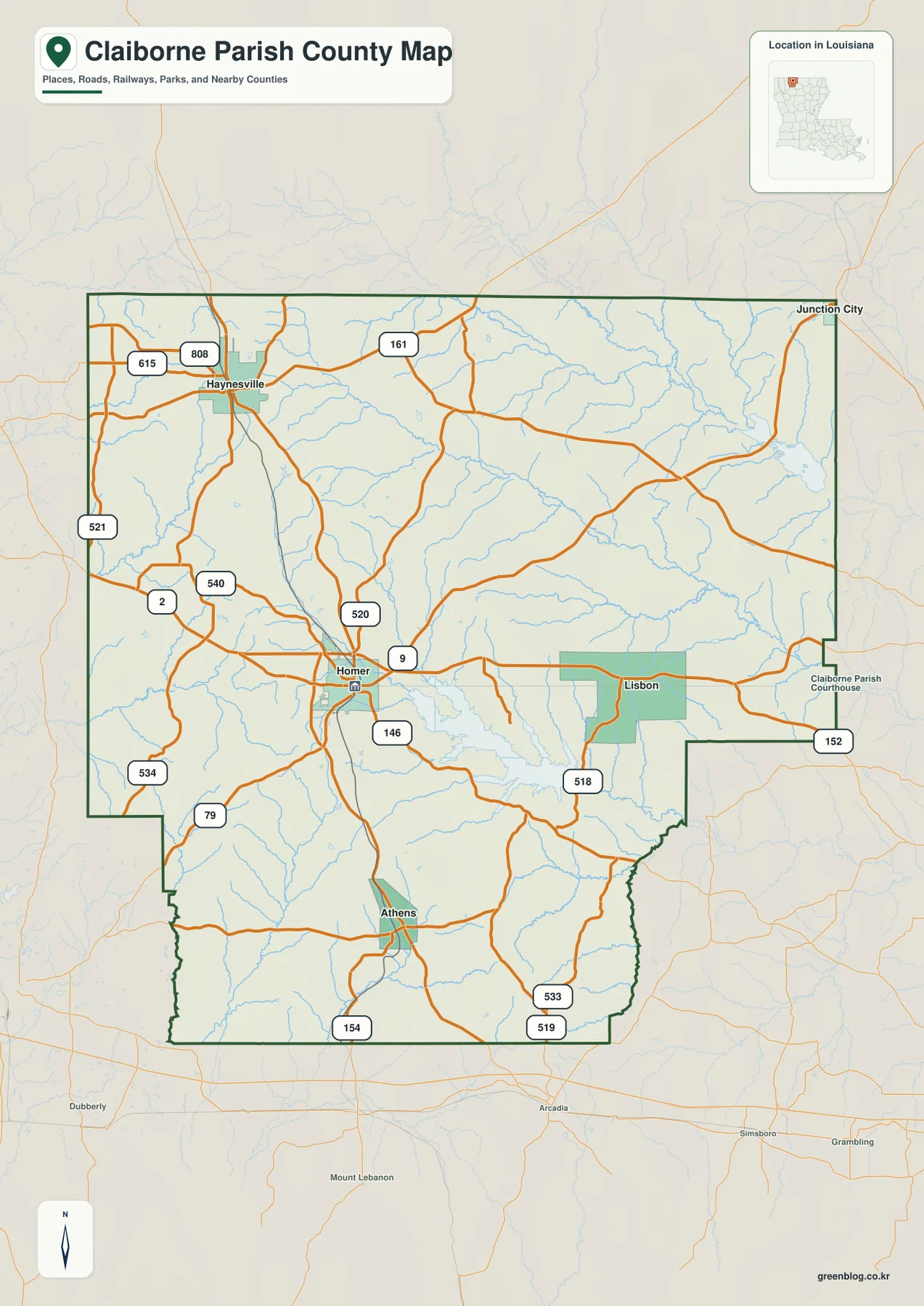
Homer is the clearest place to begin reading the general map. LA 2 crosses the central area, LA 9 runs north–south through town, and LA 520 and LA 146 branch into the surrounding rural road network. The Claiborne Parish Courthouse is labeled nearby, reinforcing Homer’s central administrative role.
Haynesville lies northwest of Homer near LA 2, LA 161, LA 808, and LA 615. The northern edge approaches the Louisiana state line, while Junction City appears in the northeastern corner. Roads are more widely spaced than around Homer, and small streams occupy much of the open land between settlements.
Athens provides the main southern settlement reference near LA 154, with LA 79, LA 533, and LA 519 helping organize the lower parish. Lisbon sits east of Homer near LA 518 and LA 152. Because the communities are separated by broad rural areas rather than one continuous urban zone, numbered roads and creek crossings are important orientation tools.
Louisiana’s official Claiborne Parish profile identifies Homer as the parish seat. It lists Homer and Haynesville as towns and Athens, Junction City, and Lisbon as villages. The Claiborne Parish Police Jury is also based in Homer. The general map is intended for geographic orientation rather than live traffic, road closures, speed limits, or private access conditions.
Homer connects to Haynesville, Athens, and Lisbon in three different directions
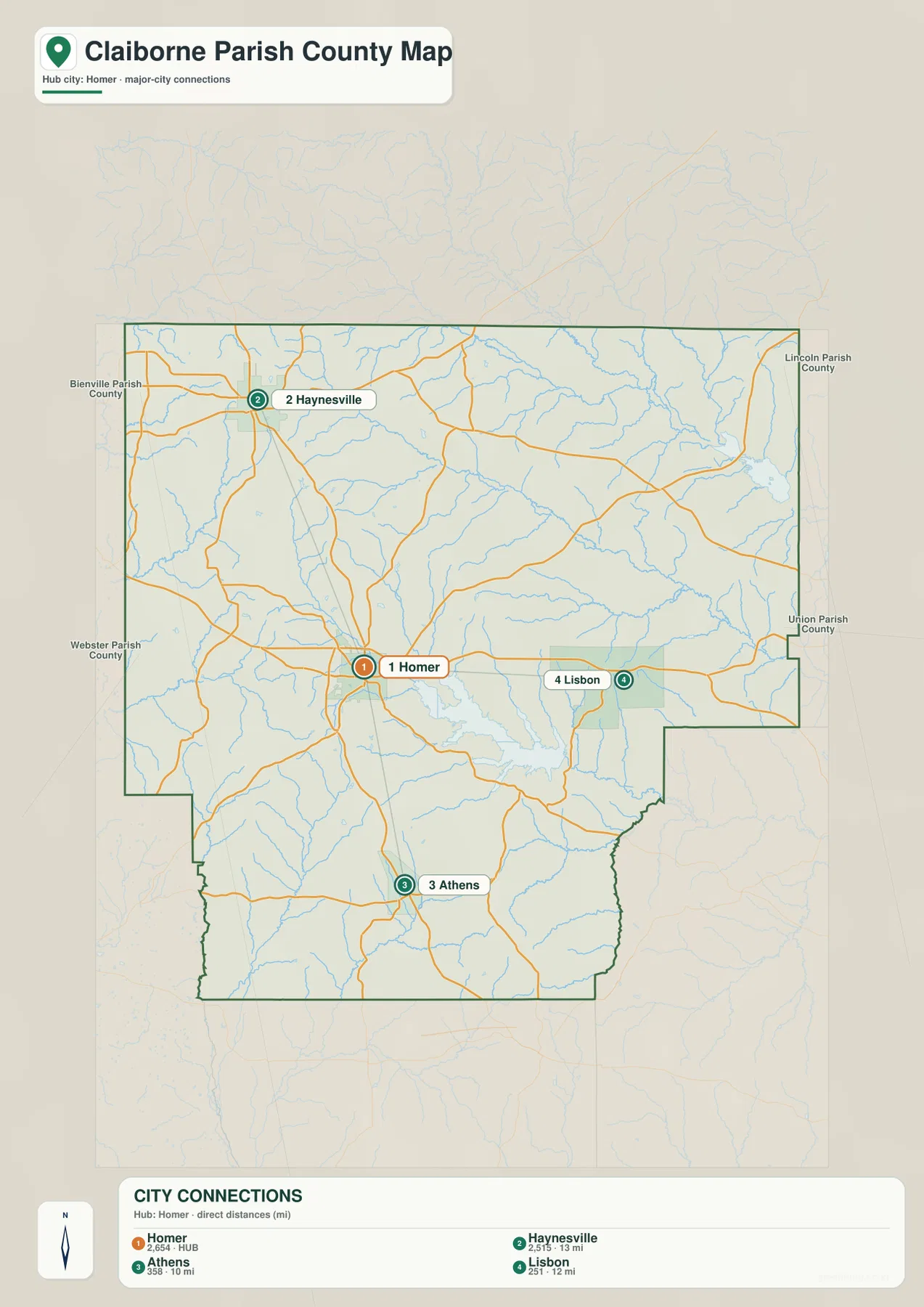
The city-connections map uses Homer as the hub. Haynesville is shown about 13 miles away, Athens about 10 miles away, and Lisbon about 12 miles away in straight-line distance. These values compare direct distances between mapped places; they are not driving distances or travel-time estimates.
Haynesville lies northwest of Homer, Athens is south, and Lisbon is east. The three spokes make Homer’s central position easy to understand. Actual road travel can be longer because routes must follow the available highways, local roads, and stream crossings, so a current navigation service should be used for trip planning.
Bienville and Webster Parishes lie to the west, while Lincoln and Union Parishes are on the eastern side. The northern edge approaches the Arkansas state line. These neighboring references place Claiborne Parish in the north-Louisiana interior between the Shreveport and Ruston regions.
The population figures printed in the city index belong to the source snapshot used to create the map and should not be treated as current official totals. Recent demographic comparisons should use the U.S. Census Bureau. The main value of this file is the direction and relative separation of Homer, Haynesville, Athens, and Lisbon.
Lake Claiborne and Bayou D’Arbonne organize the central and eastern water network
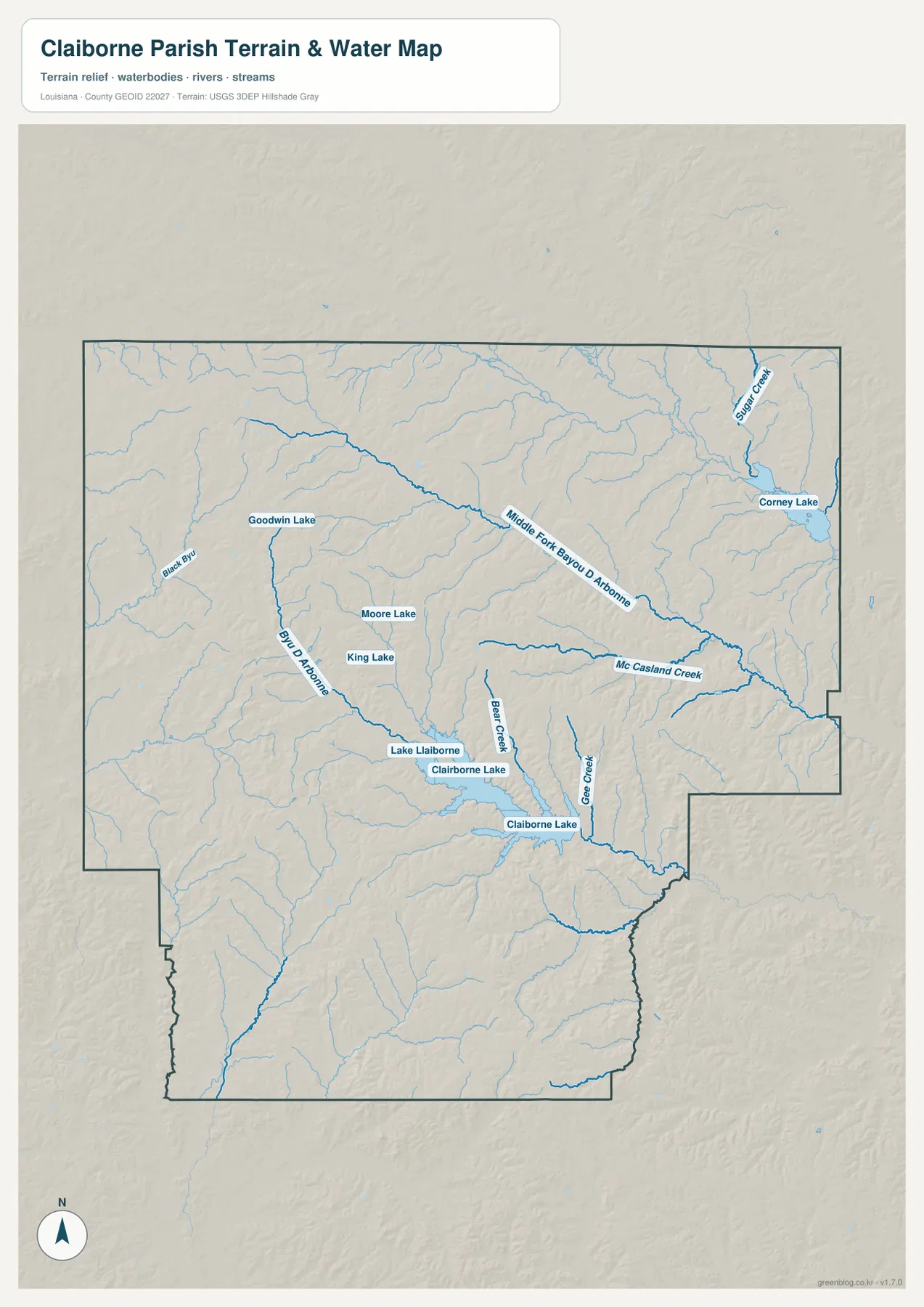
Lake Claiborne is the most prominent water body in the central-southeastern part of the parish. Bear Creek and several smaller tributaries feed the same area, while Bayou D’Arbonne extends through the western-central interior. Goodwyn Lake, Moore Lake, and King Lake add smaller reference points farther west.
Middle Fork Bayou D’Arbonne crosses the northern interior, and McCasland Creek approaches the system from the south. Sugar Creek and Corney Lake appear in the northeast near the Union Parish side. In these less populated areas, water names can be more useful than town names for locating specific parts of the parish.
The shaded relief around Lake Claiborne and the western streams suggests gently rolling terrain cut by creek valleys. This package does not include a separate elevation map, so the terrain layer should not be used for precise height measurements or engineering decisions. Its value is in showing how streams, lake arms, and ridges relate visually across the parish.
This terrain-and-water file is also not a flood-insurance map, depth chart, navigation product, legal shoreline record, levee-safety document, or parcel survey. Current flood, boating, access, and property-boundary questions should be checked with FEMA, USGS, or local parish sources.
Homer, Lake Claiborne, and Haynesville reveal three different parish settings
Homer is the easiest area to understand by roads and civic landmarks. LA 2, LA 9, LA 146, and LA 520 converge nearby, and both Louisiana’s parish profile and the Claiborne Parish Police Jury identify Homer as the administrative center. The official Town of Homer site also provides the municipal context for this central settlement.
The Lake Claiborne side works differently. LA 518 and LA 152 remain useful road references near Lisbon, but lake arms, Bear Creek, and nearby tributaries become more important for orientation. Comparing the road and water maps explains why routes east and southeast of Homer do not follow a simple grid.
Haynesville and the northern parish form a third setting. LA 2, LA 161, and LA 808 provide the strongest road references, while smaller streams occupy much of the rural land between communities. Looking at the central, southeastern, and northern sections separately makes the geography of Claiborne Parish much easier to follow.
Choose the Claiborne Parish file by the detail you need
The general map is the best starting point for Homer, Haynesville, Athens, Lisbon, numbered roads, and the parish outline. The city-connections map is cleaner when the direct distances from Homer are the main concern. The terrain-and-water map is the strongest choice for Lake Claiborne, Bayou D’Arbonne, Bear Creek, McCasland Creek, and the smaller lakes.
- General map: Use it for Homer, Haynesville, Athens, Lisbon, Junction City, LA 2, LA 9, LA 79, LA 146, LA 152, LA 154, LA 161, LA 518, LA 520, LA 521, LA 533, LA 534, LA 540, LA 615, and LA 808.
- City-connections map: Use it to compare Homer with Haynesville at about 13 miles, Athens at about 10 miles, and Lisbon at about 12 miles in straight-line distance.
- Terrain and water map: Use it for Lake Claiborne, Bayou D’Arbonne, Middle Fork Bayou D’Arbonne, Bear Creek, McCasland Creek, Sugar Creek, Corney Lake, Goodwyn Lake, Moore Lake, and King Lake.
Each original JPG measures 2572 × 3638 pixels in portrait orientation, preserving more small road, creek, and lake labels than the web previews. Keeping the original aspect ratio is recommended for printing. When using all three files, start with Homer, then compare Haynesville to the northwest with Lake Claiborne to the southeast.
Frequently Asked Questions
Which map is best for Homer, Haynesville, Athens, and Lisbon?
The general parish map is the best choice because it combines Homer, Haynesville, Athens, Lisbon, LA 2, LA 9, LA 79, LA 146, LA 154, LA 161, LA 518, and LA 520 in one view.
Is the 13-mile Homer-to-Haynesville connection a driving distance?
No. The city-connections map shows about 13 miles from Homer to Haynesville, about 10 miles to Athens, and about 12 miles to Lisbon as straight-line distances. Actual driving distance and travel time depend on the available roads, stream crossings, and route choices.
Where can I see Lake Claiborne and Bayou D’Arbonne most clearly?
The terrain-and-water map shows Lake Claiborne, Bayou D’Arbonne, Middle Fork Bayou D’Arbonne, Bear Creek, McCasland Creek, Sugar Creek, Corney Lake, and several smaller lakes. It is a geographic reference rather than a flood, depth, navigation, or legal-boundary map.
Map File Information
The ZIP contains high-resolution JPG versions of the Claiborne Parish general map, city-connections map, and terrain-and-water map. Use the previews to check Homer, Haynesville, Athens, Lisbon, the main roads, Lake Claiborne, and Bayou D’Arbonne before opening the original files.
- Included Files: Use only the versions confirmed in the article and supplied images
- File Type: Use the confirmed download contents
- Intended Use: Printing, education, presentations, and map-based projects
Related Maps
Sources and references
The geographic discussion is based primarily on the supplied Claiborne Parish maps, with official parish, Homer, Louisiana, and federal geographic sources used for context.
- Claiborne Parish Police Jury — official parish government and local information.
- Louisiana.gov – Claiborne Parish — official parish profile, parish seat, and municipality list.
- Town of Homer official website — official municipal information and services.
- U.S. Census Bureau TIGER/Line Shapefiles — official geographic boundary and road data.
- USGS National Hydrography — federal hydrography background for streams, lakes, and water features.
Green Map creates custom-edited map images using open geographic data sources such as geoBoundaries, Natural Earth, OpenStreetMap, and government open data. These maps are edited visual materials, not raw data files, and are provided for education, documents, presentations, and graphic reference.